Search the Community
Showing results for tags 'landscape area'.
Found 19 results
-
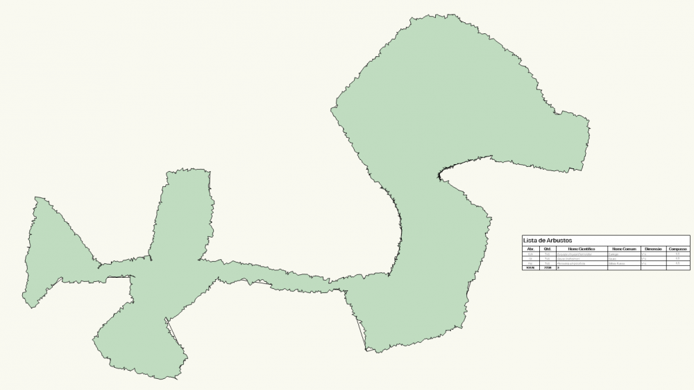
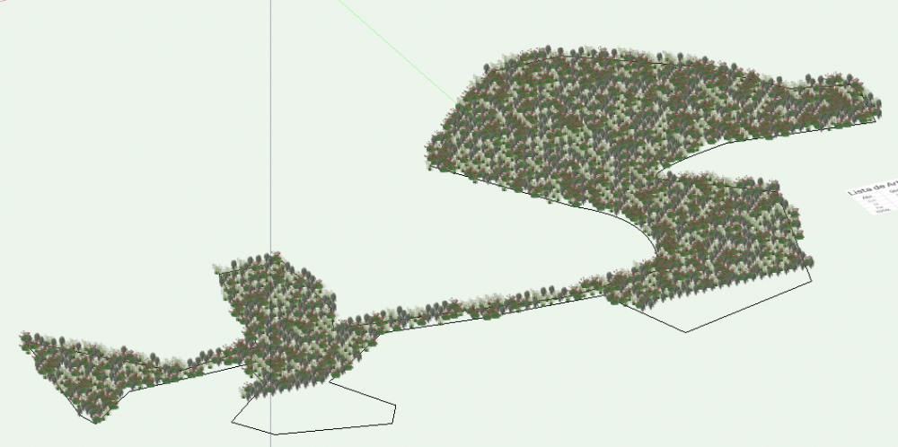
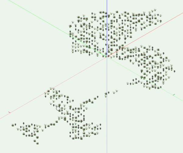
Hello, I have some landscape area tools with plants attached/containing: problem #1: the plants (3D objects) are only visible when the active layer ist the one containing the landscape area problem #2: only the landscape area exports to my ifc file, the plants are missing. (note: got the plant tool (any everything else i use) mapped to my preferences - so a missing ifc assignment is not the problem) an unacceptable workaround would to "explode/convert to group" because I export my files on a regular basis and don't want to redo it before every export. any solution, anyone? Cheers
-
 An important feature in Autodesk Revit for effectively changing objects in large BIM models is the ability to right-click on an object and select all equally objected Styles in the entire model and change properties or replace objects with another Style. See the attached lines that describe this possibility in Revit, "Select All Instances". https://www.youtube.com/watch?v=NIyh8h_3DtM https://help.autodesk.com/view/RVT/2022/ENU/?guid=GUID-AB47C2E6-80C4-4C13-ADF1-B77775DD41D5 I have not been able to find this feature in Vectorworks. Am I not looking in the right place or is this something that doesn't exist? If this function does not exist, I would like help to create a script that will help. Suggestions on how I understand this can be done. When I have marked an object in the model, I want the script to find the Style Name of the object and then select all similar objects in the entire model. Then I can directly change properties in OPI or I can replace the objects with another Style. If we can also run a script that only searches for objects on the same Design layer and/or only among objects that are visible in the view, just like in Revit, it will be even better. We need this function since we don't necessarily have other parameters to search for that can do this job. Our models are used directly to build after so that we do not use drawings for construction. Then the model is not structured based on Attributes that the Select Similar Preferences function is based on. I am unable to use this function to make selections in the model as described above. Maybe I didn't understand this function. If I'm wrong, I'd really appreciate it if you could show me how to set this up in Select Similar Preferences.
- 25 replies
-
- 2
-

-
- selectsamestyle
- landscape area
- (and 1 more)
-
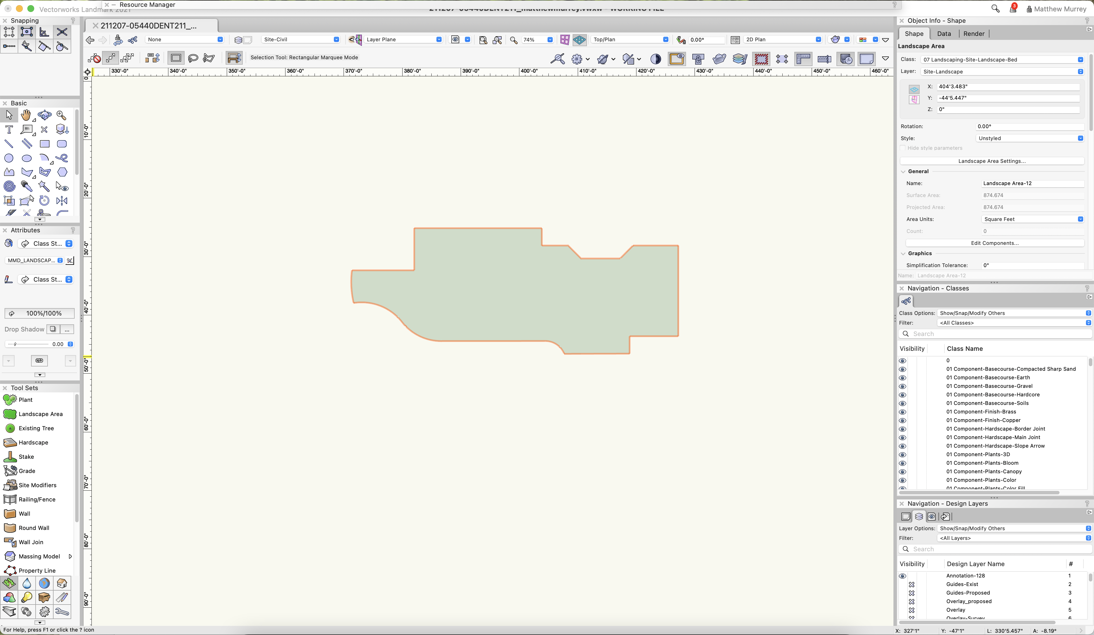
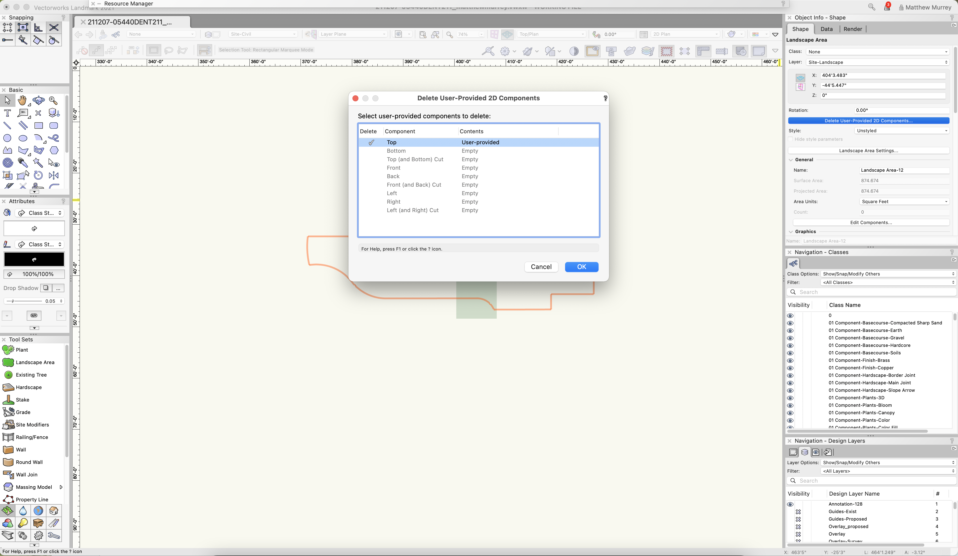
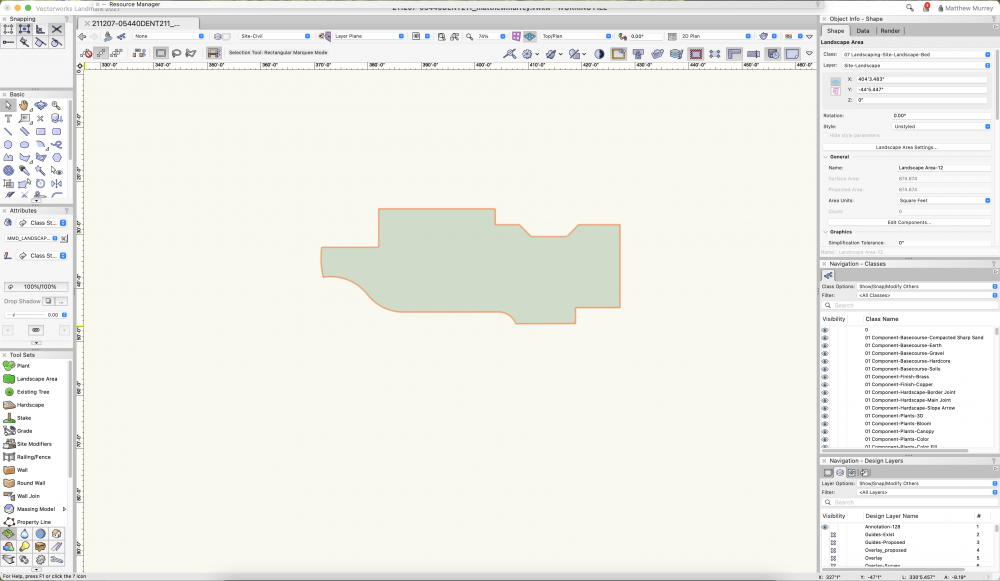
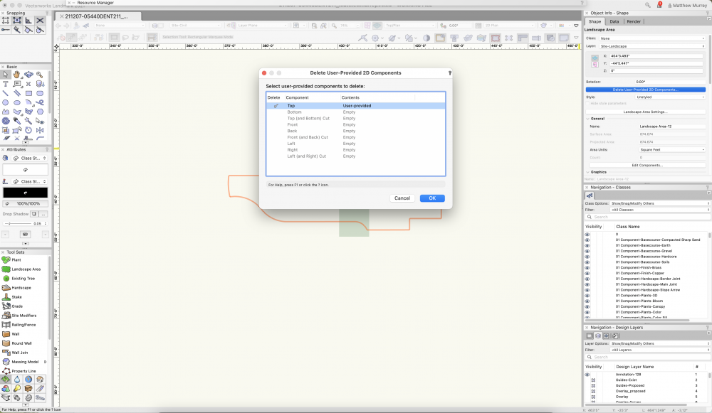
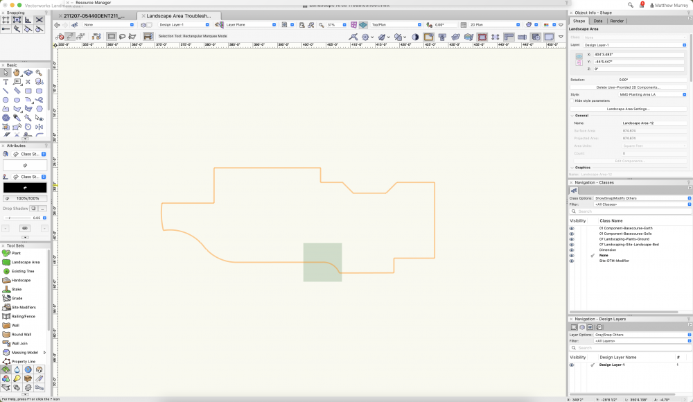
Since the release of landscape areas using styles, I have experienced an issues with the 2D/plan view that can only be resolved by disassociating the style. It seems that when using the landscape area by style, it auto-generates a 2d component that does not follow the path, but instead represents a square. See screenshots and vwx for reference. Landscape Area Troubleshoot.vwx
-
I am trying to streamline the documentation process for designed plant communities for both installation and visualizing with clients (along with my own forgetfulness). I have a resource drawing that I keep for plant objects with records attached that describes the varying interest season-to-season. I am experimenting with pulling these object styles for use with landscape areas, then using data visualization to show floral, foliage interest for a given season. This works with individual plants but not plants nested inside a landscape area style. Do landscape area styles retain records for plant styles attached to them? If so, should they show up in a data visualization with the records attached? I will try to clean up a test drawing and post on Monday. Cheers PWF
-
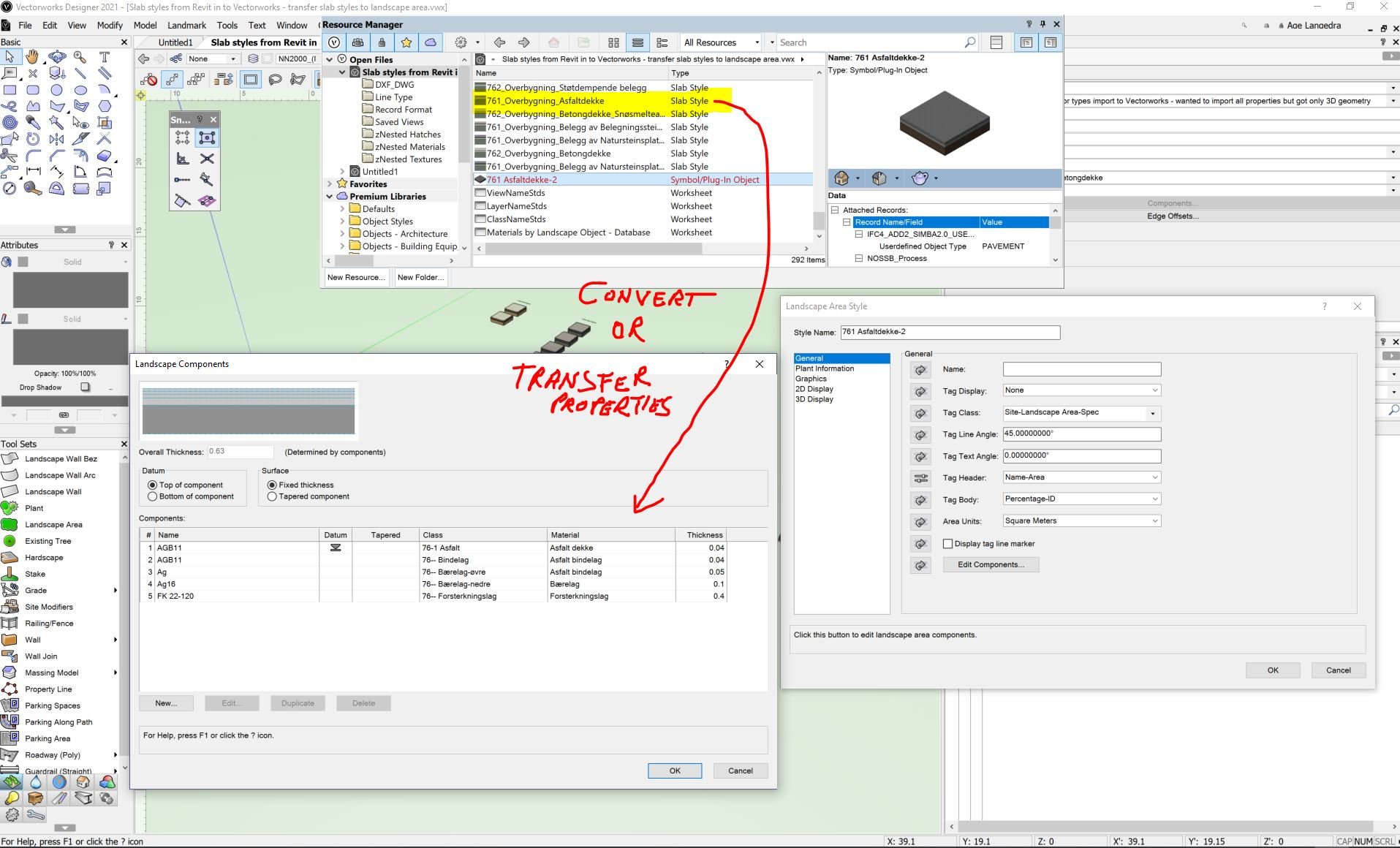
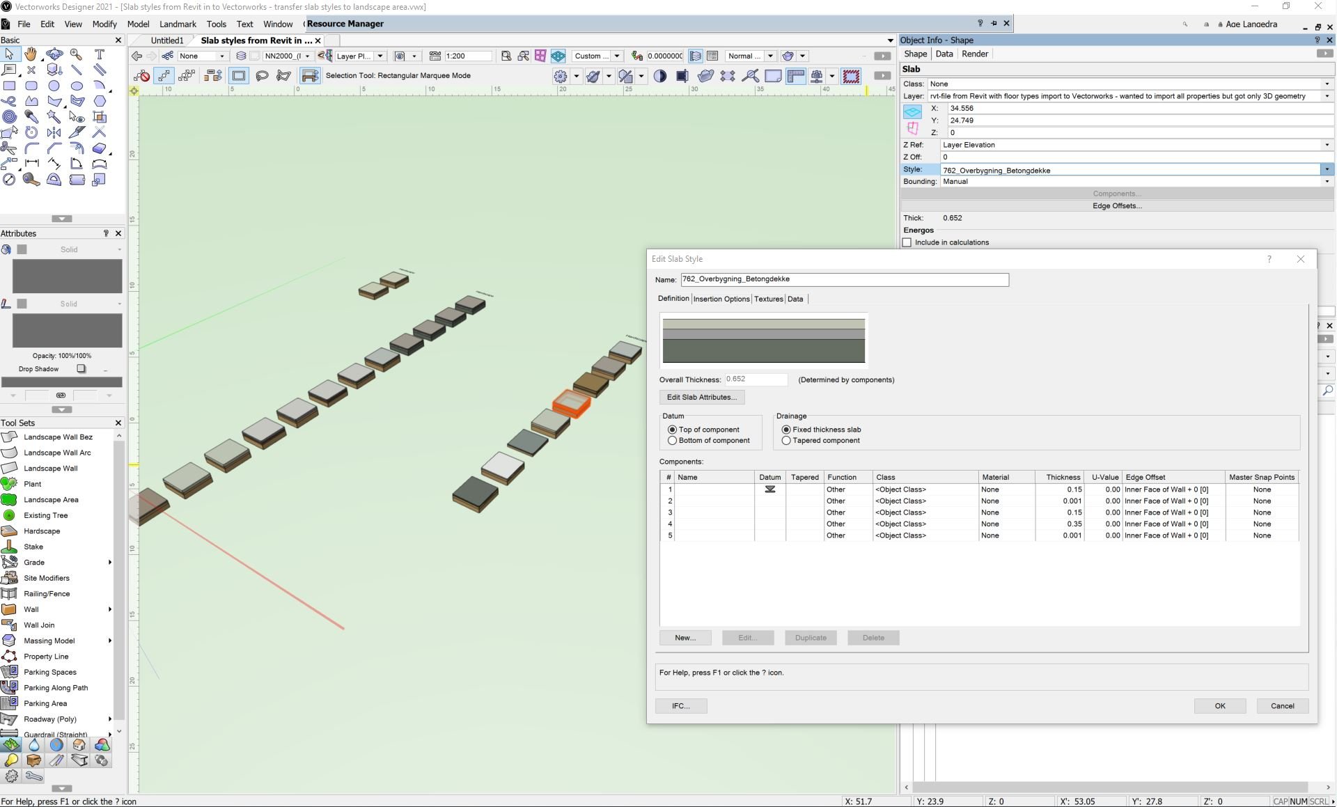
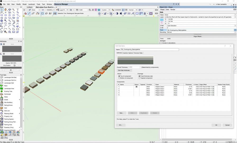
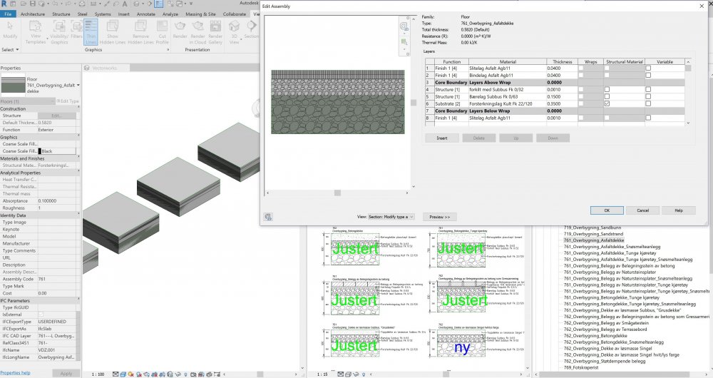
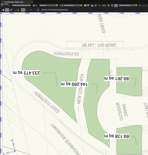
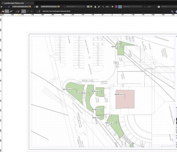
In Revit I have dozens of "floor typs" / slab styles that I have imported to Vectorworks. In Vectorworks I have the opportunity to use both Hardscape and Landscape area. How can I transfer Vectorworks slab styles' components / layers with materials, thickness and preferably IFC properties to Landscape area's components? Is this possible? Is there a time-saving work around? Hope I can avoid going into building up all landscape area styles with countless components, names, class, materials, tickness, etc manually. Currently I only work with landscape area and not hardscape to save time in the project. We must also supply site model surfaces for machine control and for other disciplines. Therefore, we link all landscape area and landscape area used as hardscape to the same site model surface. Hoping for answers that can save me countless hours of work. Sorry the text in the model and drawing is in Norwegian, but I hope the issue is clear anyway.. Revit Floor types import to Vectorworks as Slab Styles_R2019.rvt Slab styles from Revit in to Vectorworks - transfer slab styles to landscape area.vwx

-
Hello, I just wondering if anyone had experience that having the tag upside down in the design layer, and showing okey in the sheet later? A bit hard to read when I trying to work on my design layer.... In my design later, I have my text upside down... And in my sheet layer, it looks okey.
-
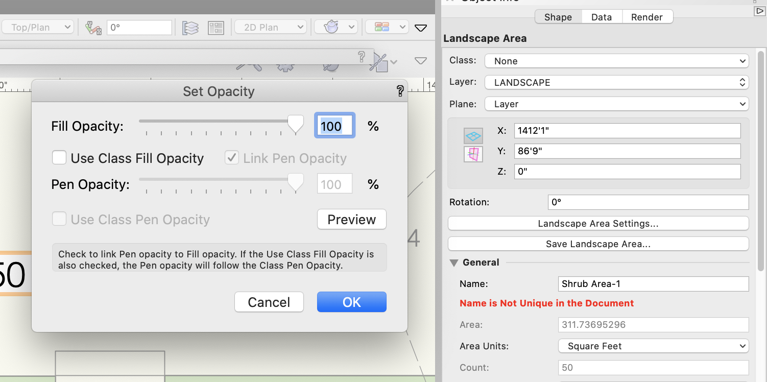
 For years, I've been wishing that you could assign different opacities to fill and pen style in a Landscape Area. You can do this with most other objects, but not a landscape area. It would make life a lot simpler as I like drafting with a more transparent fill, while having the pen set to 100%. Basically, I just want to be able to uncheck the "Link Pen Opacity" box in the "Set Opacity" palette.
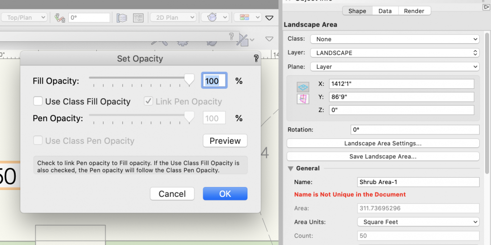
- 3 replies
-
- 7
-
-
- site design
- landmark
- (and 3 more)
-
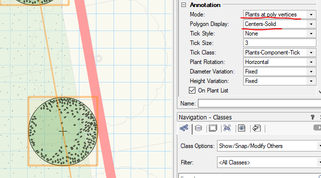
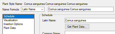
Hi All, I downloaded and installed v2021 yesterday and worked in it today for the first time. There are a number of new functionalities which seem to be a way forward, but... There is always this but. 1. I like what has been done to Landscape Areas. Some of the implemented changes were very desired and flagged up before. However, I seem to struggle with picking up the LA settings in one instance to apply elsewhere with the Eye Dropper tool. I can't pick up the planting settings. I used to be able to do that in v2020 with no problem at all. What ED settings should be ticked to get that work? When setting up the component layers for the LA, the levels seems to be not as expected. I set my LA datum to top but rather than the top of the LA being at level 0, it protrudes some 185 over this level. Any ideas? 2. I created some specimen planting along a polyline with Plant tool and set the plants to be on vertices with the solid line. Unfortunately the line is not visible at all. Only when I hover over the group or select it. Is it controlled by any class? Perhaps I have this invisible/ turned off. 3. When I try to align the hatch of a Hardscape object with the Mapping tool, I struggle to snap to the perpendicular point. Is there any setting that controls it? Perhaps I need to set it up again in v2021. 4. In Plant Style, I noticed that when I have the Style Name Formula set to Latin name, the Style name will have the latin name duplicated. The images below won't illustrate it properly, because they show the result. When I create a style it has nothing in the Name Formula. I changed it to Latin Name and obviously gave the Latin name to the plant.When save the style, the duplication happens. That's it so far. Any thoughts?


-
I cannot do a viewport override on landscape areas, to have them show up with color in one viewport and grayscale in all others?
-
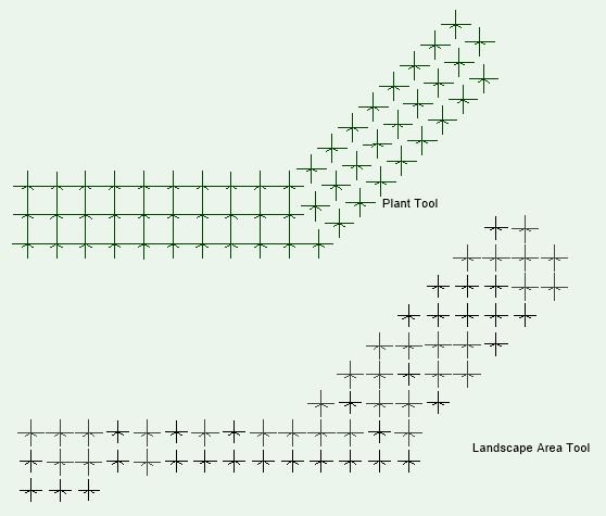
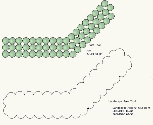
Hi guys, I've been working with some tools to improve my planting schemes. The Plant tools already a very complete tool but there's a lack on it: random planting schemes. The normal reply would be the Landscape Area Tool. Take the following example: a certain area, choose 3 species and there you go. There is one problem: it doesn't give us the individual planting scheme in 2D, but it appears in 3D mode: I explored a very interesting Marionnette Object that would help: The result: But there is a problem: it doesn't give you the control that the Landscape Area Tool allows (qty/m2, %, etc.) So, am I missing someting or maybe this would fit on the Wishlist Forum? It's obvious that the information is on the Landscape Area object (otherwise it wouldn't give us a 3D representation and quantities). Why don't make it available on 2D representation? This would be important for Executive Plans, sometimes it is a little to vague to let that information missing. Thanks!!!
-

Landscape Area Settings - Show plant count after adding plants?
KarynT posted a topic in Site Design
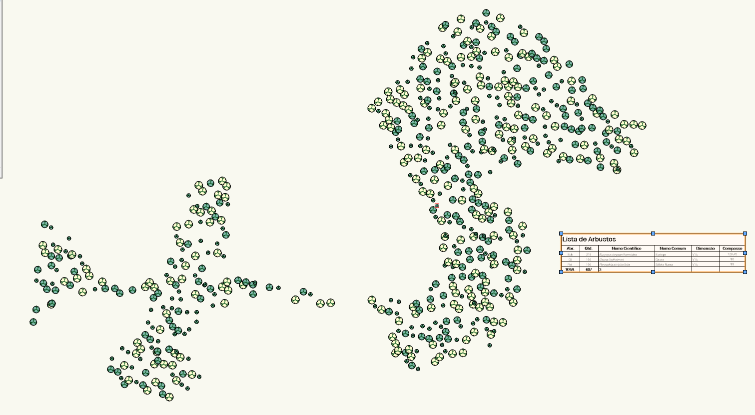
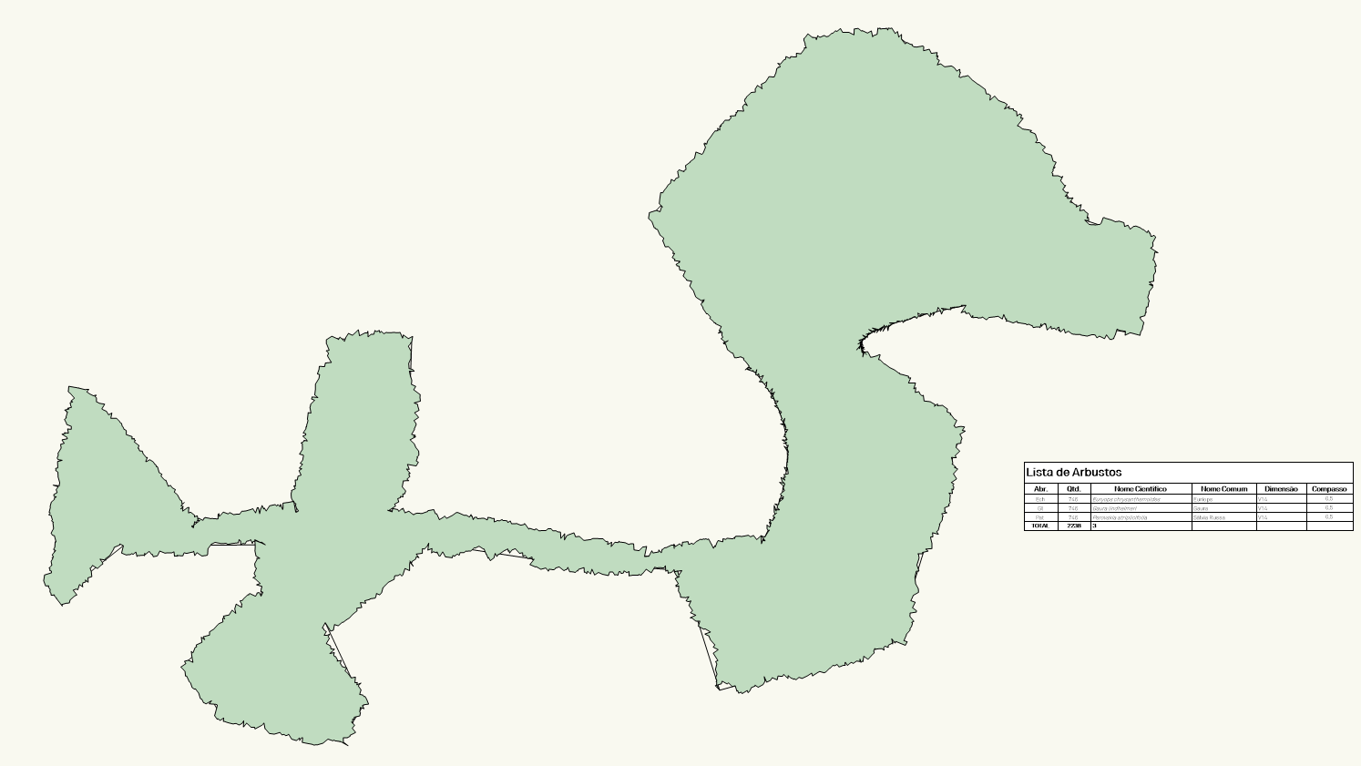
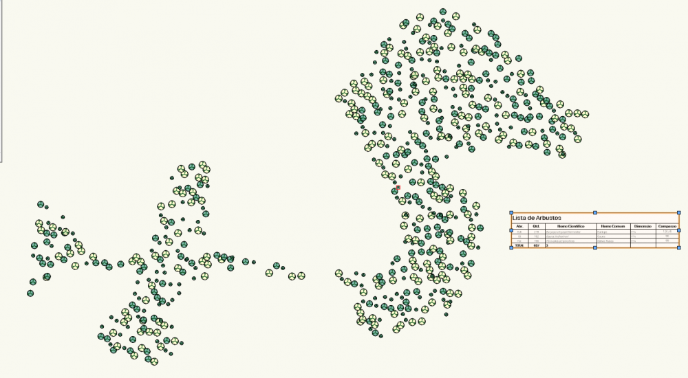
I'm trying to reverse engineer a landscape area after receiving a list of plants the designer wants to place in a bed. Rather than place a group off the drawing area, I'd love to create a landscape area & populate it with the desired count of each species. As I mess about with the settings, click ok and see that it's not right. (I am probably missing understanding of how this should be done without the computer. I've watched many a video, read tutorials & it's just not sinking in on how to use the settings.) Is there a way to preview a count before committing to the settings for rate & percentage? I might want to alter a setting if trying to ensure that I'll order a full tray of plugs shows I'm off. Might this be considered for a wish list item if not? Here is my practice file. You'll note that I duplicated the landscape area for the mass of the Carex while experimenting with the other plants. Thank you! VW2020 sp2.2 (MacBook Pro-2.3 GHz Intel Core i9/Mojave 10.14.6) LANDSCAPE WORK.vwx -
 I use landmark and use additional plant records to include information about landscape areas such as seed mixes which then input into my schedules (worksheets). As these detailed soft and hard landscape drawings can get very heavy on larger sites (very painful for my work flow), I would like to split up the drawings into seperate files (eg. soft, hard, specific designed spaces) which I then reference as viewports into a drawing with the sheet layers and worksheets. This helps for a number of people to work on the project at once by splitting up the drawings in this way. This works well until I come to schedule the drawings and the records are not imported although landscape areas and plants are. Currently I have to combine my colleagues drawings before scheduling which is very time consuming and usually crashes. It seems sensible that all data is available from referenced viewports.
 -
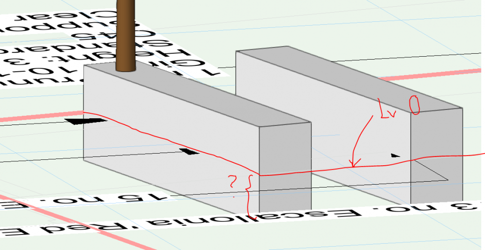
Hello all, We are trying to create a hedge with multiple species in it, that is not simply linear (i.e. it needs to turn corners) and use 3 staggered rows. Ideally we would like to use the hedge tool to do this for accurate numbers (landscape area tool appears to miscalculate because it is based on m² rather than linear m). Hoping somebody might have a useful, reliable, workaround for this you can recommend please? We referred the problem to Service Select, but their (very slow!) response was as follows: There isn't a Hedge tool and the Plant tool can only plant an single species in one group, but you could create your hedge by putting lots of different plants together. Alternatively, the Landscape Area does have a Meters on Center option My answer / further observations: There is a ‘hedge’ setting in the ‘Plant’ Tool, which is what we were referring to. It would be very useful if this could be developed to allow multiple species, and staggering of the hedge rows. Neither of the current workarounds provides a satisfactory and reliably calculated route to what Landscape Architects often need, which is a staggered double or triple row hedge of several species (e.g. a mixed native hedge) that is able to ‘turn corners’. Problems with the current workarounds (see attached screenshots): The ‘plant tool’ will not allow multiple species. Attempting to create a single species hedge in a ‘triangular array’ (staggered) with the plant tool does not work to display a hedge, it has to be done ‘along poly edges’ and then multiple rows displays as a grid, rather than allowing staggered rows. The ‘Landscape Area’ Tool, although it will allow plants to be organised by ‘Metres on Centre’, doesn’t show them as staggered rows, and you have to draw planting by working out the depth to draw a shape depending on spacing and row numbers, then check against 3D view to see how many rows you have. This is not easily edited as ‘3 rows based on a line’ would be. It is arranged as a grid rather than following a path, so that anything but a straight hedge is particularly challenging. Even on a small, simple scale, you can see in the attached screenshots that the calculated numbers are coming out at about 10% different for each of these workarounds. Thanks, Amanda

-
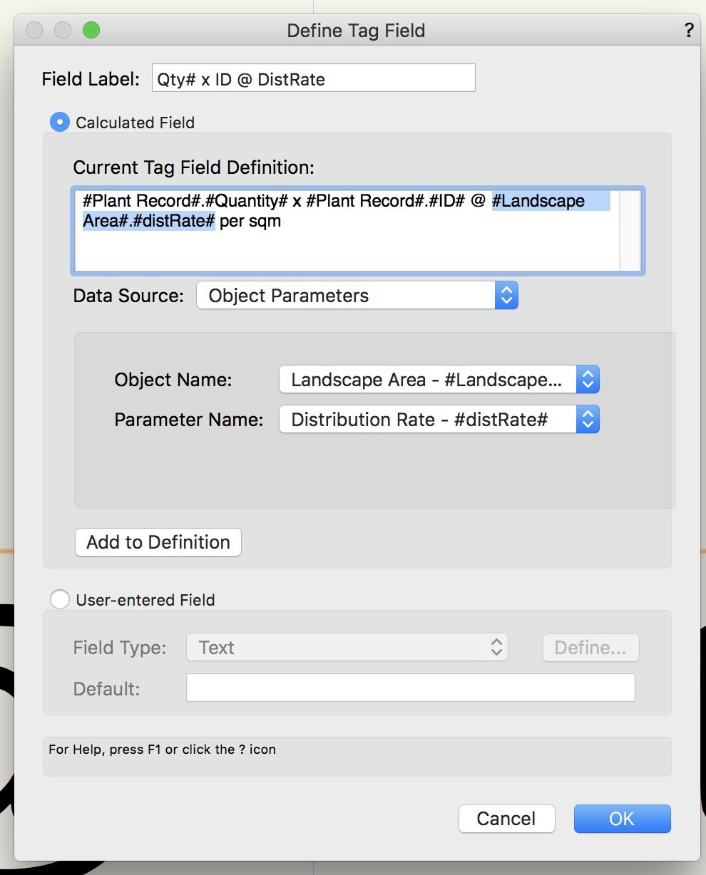
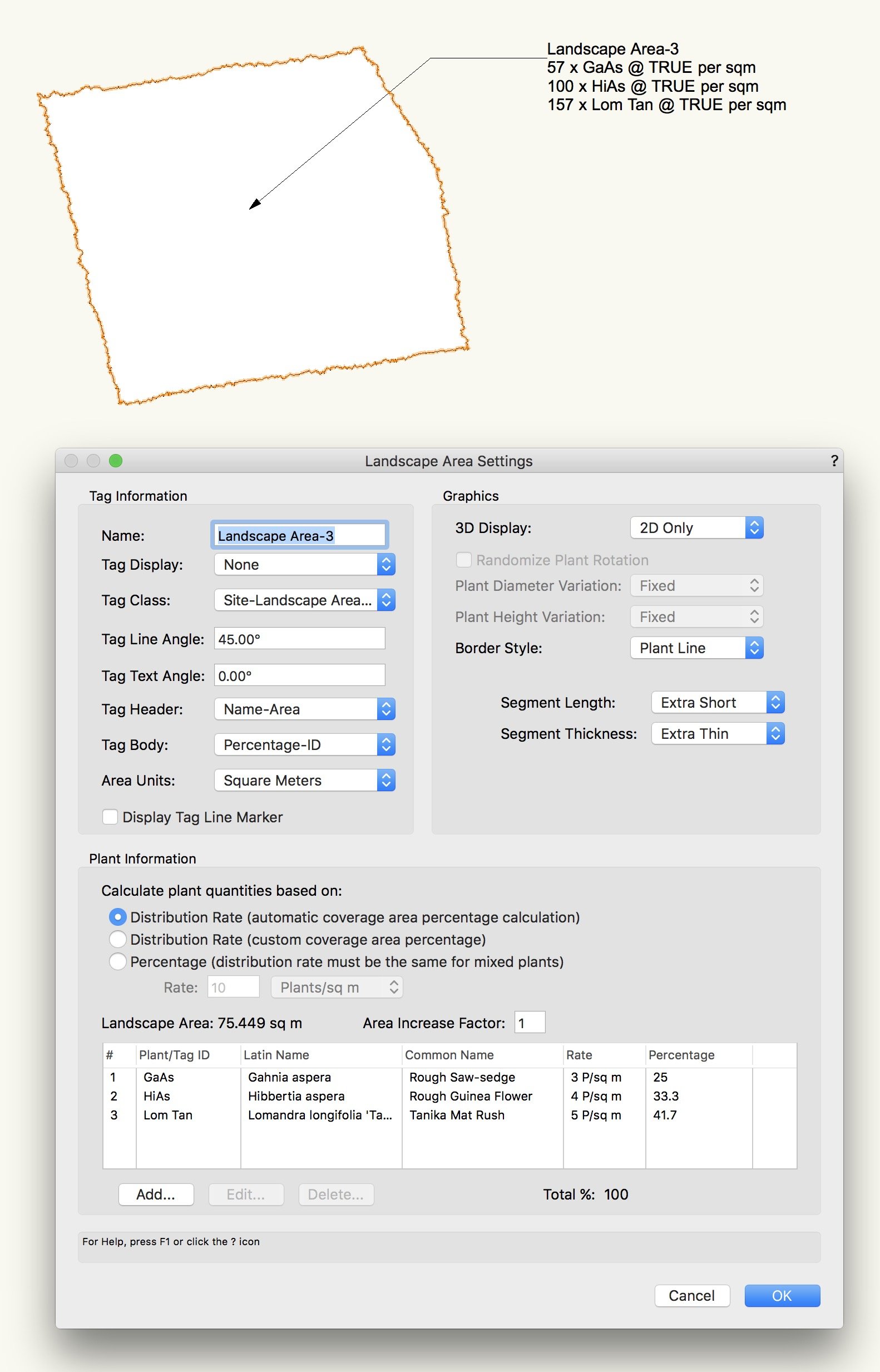
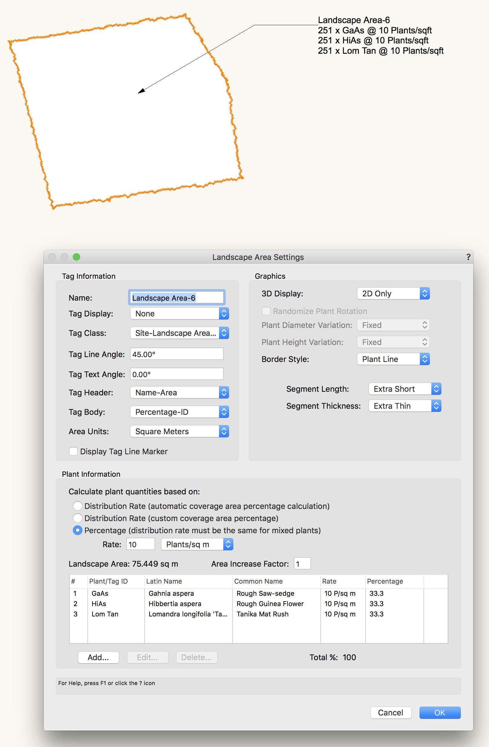
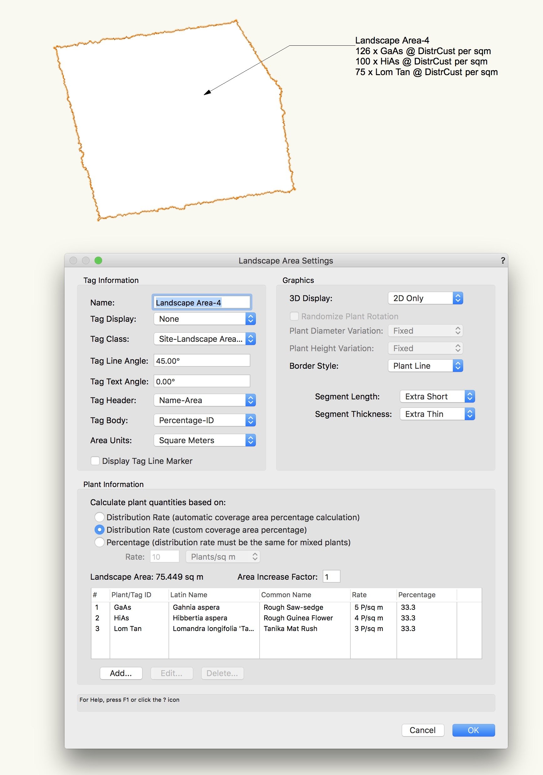
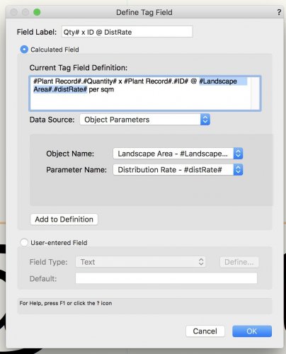
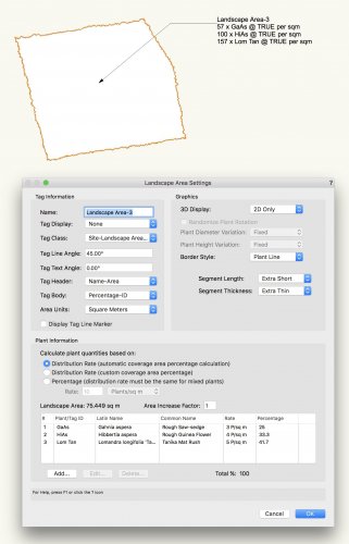
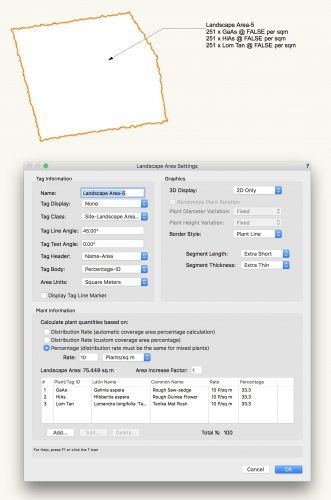
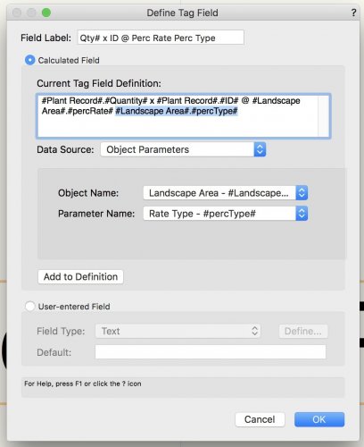
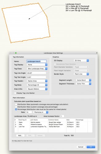
Hi, I found two landscape area-related data tag bugs. Is this the place to report it? Dynamic Text Bug 1: #Landscape Area#.#distRate# is returning TRUE, DistrCust or FALSE instead of the actual distribution rate of each species. See below Tag field window and Landscape Area 3 to 5. Dynamic Text Bug 2: #Landscape Area#.#percType# is giving me Plants/sqft instead of Plants/sqm, while area unit (and all other settings) is set to Square Meters. See below: #Landscape Area#.#percRate# is working fine (see Landscape Area-6 above) but it is not so useful for us because our planting rates vary within and across landscape areas.

-

Hardscapes and Landscape Areas - Styles
ericjhberg posted a question in Wishlist - Feature and Content Requests
It would be incredible if Hardscapes and Landscape Areas could be managed by Styles, similar to walls, roofs, slabs, titleblocks, etc. With this functionality, these would be saved as resources similar to Wall Styles, Roof Styles, Slab Styles, etc. and then could be edited in one location to make changes throughout the document. Currently the functionality of Save Hardscape... or Save Landscape Area... does create a resource manager resource, but that has no effect/connection to the instances located in the drawing. Furthermore, it really can't even be edited in the resource manager. Right now, the only way to enact large changes to multiple similar hardscapes is to make the changes to one and then use the match properties to apply it to all others. There are several reasons why this isn't ideal, Very Slow - Matching properties to hundreds of hardscapes or landscape areas can take forever to complete Inaccurate - The match properties workflow is a manual selection workflow and is only as precise as the users selection abilities/criteria It's time to rethink the way the Landmark tools fit within the greater movements of VW tools, I feel like they are out in their own little world and really should be brought into the fold. -
Is there any ability to control the opacity of the landscape area fill without impacting the it's tag?
-
 To allow better use of landscape areas it would be great if the tags could resemble those of plants. See image. It's great that we have the ability to make a custom landscape area tag however it would be helpful to give it similar appearances to plant tags.
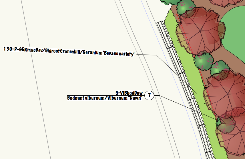
-
 The way Landmark is set up means that once I draw a polygon I have to convert it to a landscape area, an irrigation design area, a hydrozone area, and an irrigation drip area. Having all of these different objects works up until the point at which the design starts changing. Then I have to edit the size/shape of each object individually every time the architect changes their design or the planning department asks for a change. This is a huge time waster in my office and incredibly mind numbing work. Can you either link all of the areas so editing the size/shape of one of them edits them all -or- allow one area to contain all of the same information?
 -
 When using the Landscape Area tool I want to add plants to the Plant Information list (i.e. the plant mix) from my own plant .vwx file via the 'Edit Plant Information' pop up. At the moment I'm having to drag them in through the resource browser which is a bit of a slow process. Is there a way to add my plant .vwx file to the 'Edit Plant Information' pop up? Apologies if there is an existing answer to this - I have had a search but couldn't find anything.