twaikin
-
Posts
16 -
Joined
-
Last visited
-
References links broken by Google Drive on Monterey,
twaikin replied to twaikin's question in Troubleshooting
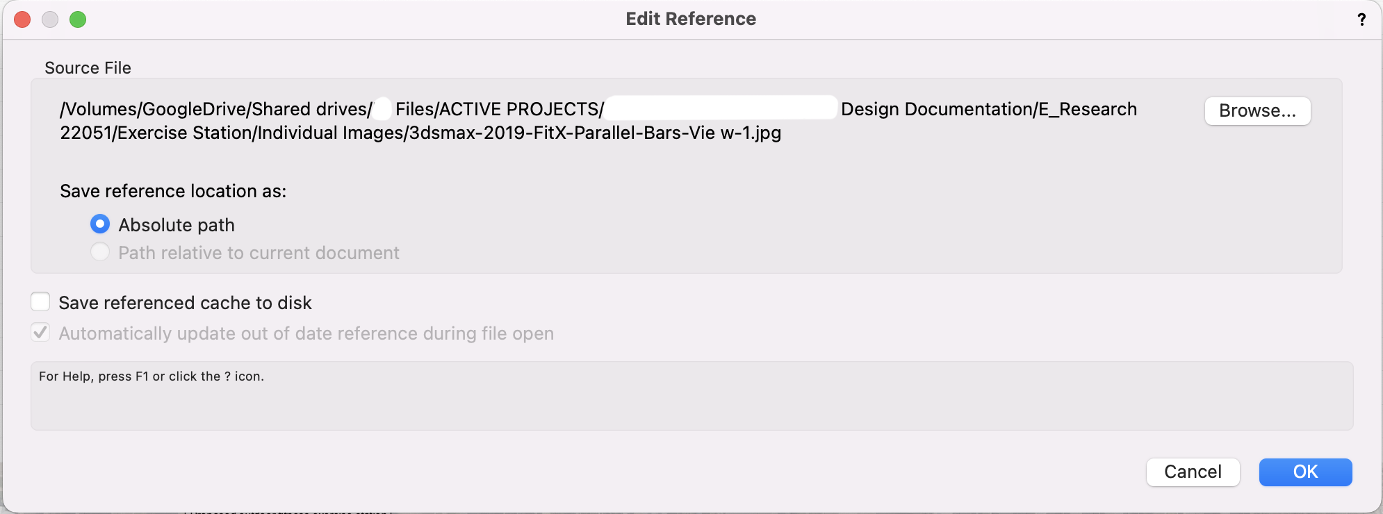
Hi Peter, Thanks, once I got around to change all the absolute paths to relative paths (took a while), they worked. Glad it does! I blame WFH of not trying this from our office sooner. Absolute Path doesn't work on Google Drive anymore but at least it can be fixed. -
References links broken by Google Drive on Monterey,
twaikin replied to twaikin's question in Troubleshooting
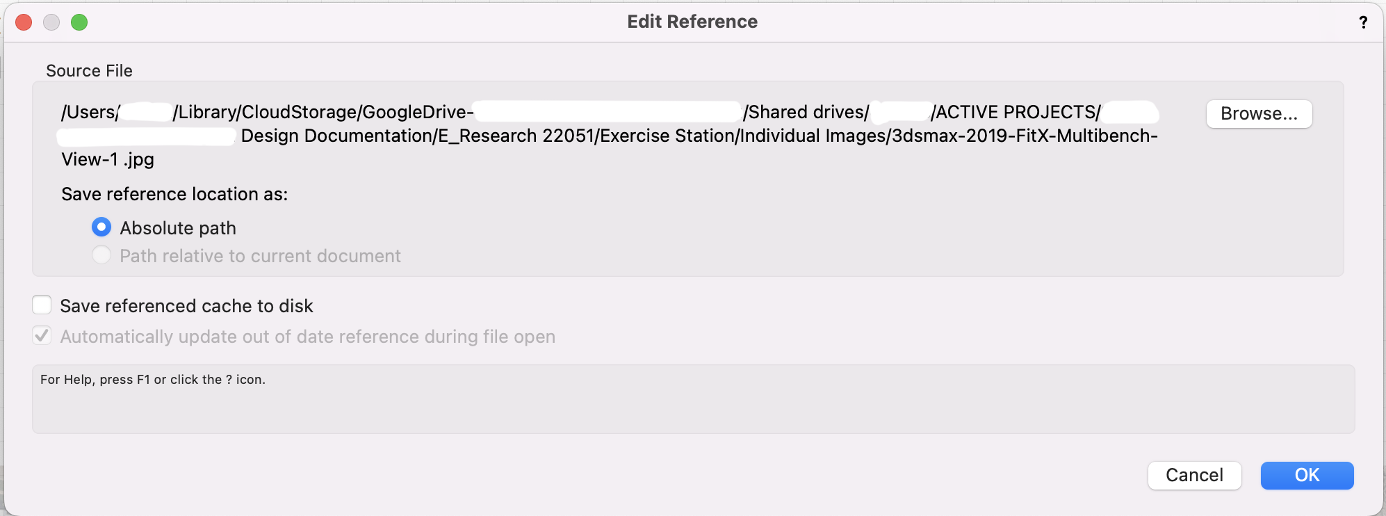
I can't put anything under Macintach HD either. So I put the Google Drive alias in the Applications folder. I tested it in VW, and VW (and Finder) still see the file path as per the original under /users/, not Applications/Google Drive alias/. I guess in the mean time we could still work by importing all files into the VW directly and not use referencing at all. -
References links broken by Google Drive on Monterey,
twaikin replied to twaikin's question in Troubleshooting
Thanks Pat for going through my post! I like the the idea of this temporary work-around but the computer is not allowing me to do so. Edit: I created a Google Drive Alias, tried to drag and drop it at the same level as the HD.
-
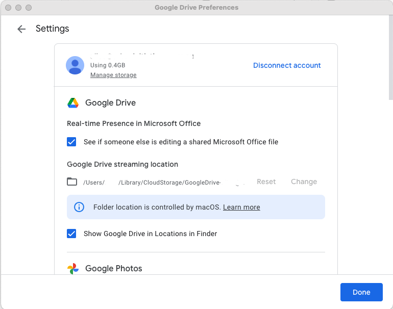
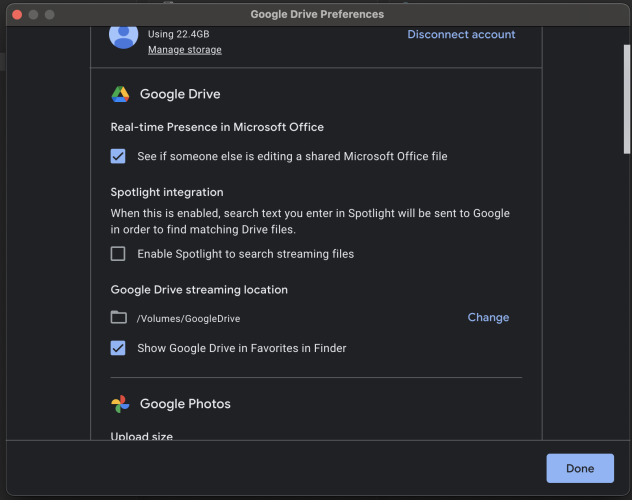
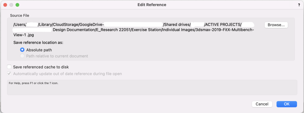
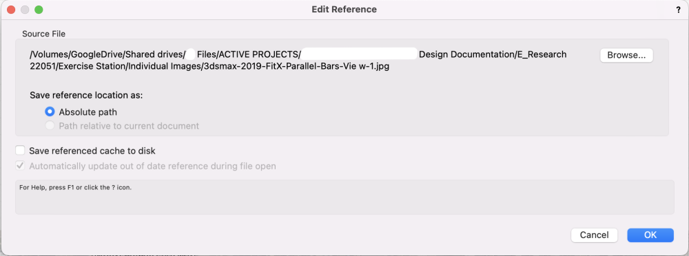
Setup: Multiple iMacs, mostly Monterey & Big Sur, using Vectorworks 2022 (&2023) and having references files such as pdfs and images shared on Google Drive Problem: Since Monterey, Apple introduced File Transfer and Google Drive has moved the file streaming location from /Volume/Google Drive to /Users/[username]/Library/CloudStorage/Google Drive-[user email address]/. Notice the computer-specific identifiers on the file path. While working by myself is fine, I just need to update the reference link once. However, when working across multiple computers, the discrepancy in the Google Drive streaming locations means that ever time I change a reference link in a VW file, it will break the link for my colleague whose Google Drive is streaming from a different location. See the variations in Google Drive Streaming locations below. For most of our computers, we weren't able to change the streaming locations. For many of our projects which we reference a lot, this has a huge impact on our workflow. The References panel is a sea of red if more than one person works on a job now, with Google Drive now introducing computer-specific identifiers in the file path. We always push back updating MacOS but Monterey is no longer the newest OS anymore. What Vectorworks could do: This is not just a Vectorworks issue obviously, but Adobe Suite has resolved this. On Adobe Indesign 2023, this discrepancy in Google Drive streaming location doesn't break the link across multiple computers. I am hoping Vectorworks could magically resolve this too. Until then, we are practically unable to have multiple computers working on the same job using Vectorworks. Way to test this: Open a VW file using a Mac with Big Sur. Reference a file on Google Drive. Open the same VW file using a Mac with Monterey which has the Streaming Locations changed (not all of them have!). Link to a Google article on this change: https://support.google.com/drive/answer/12178485?visit_id=638036314598550785-384021587&p=file_provider&rd=1#fileprovider
-
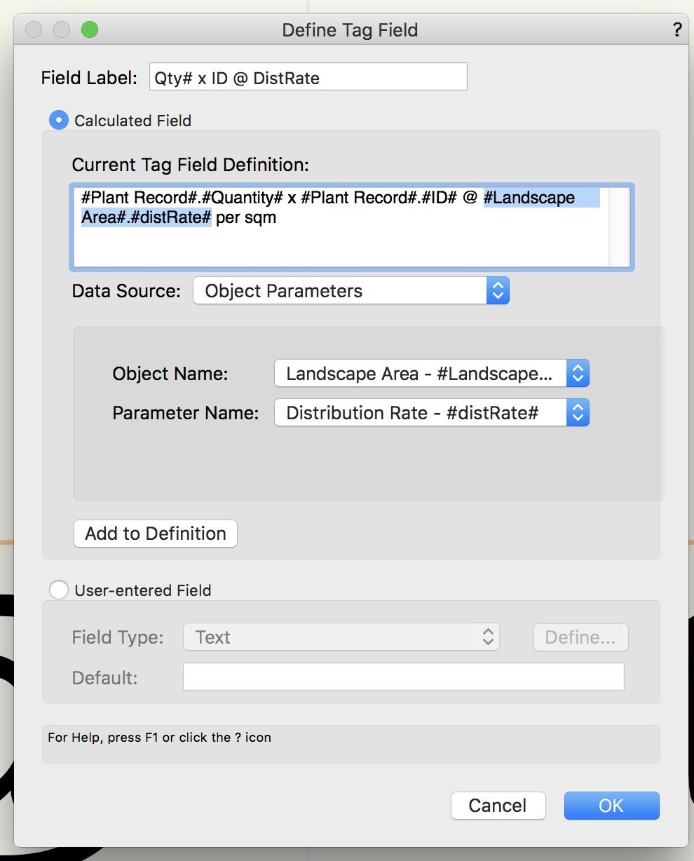
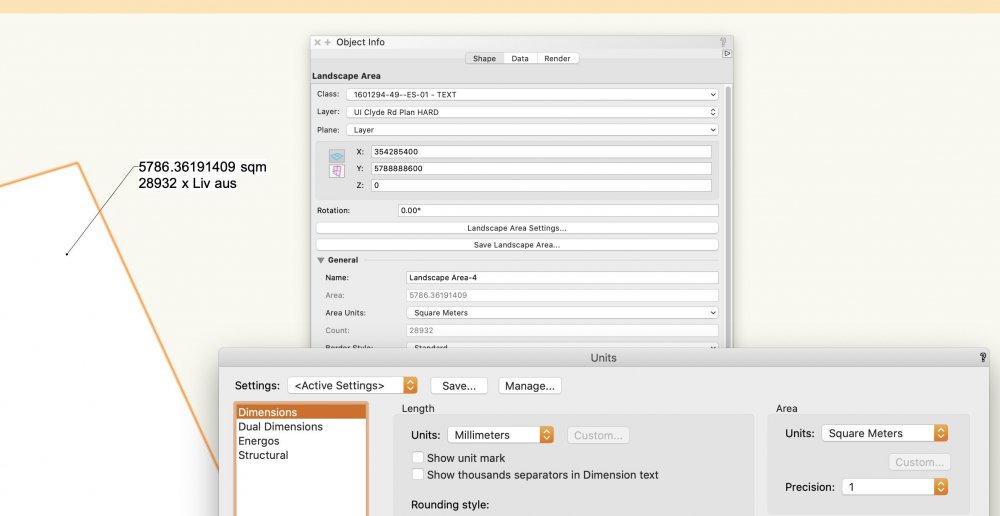
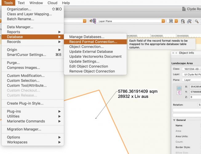
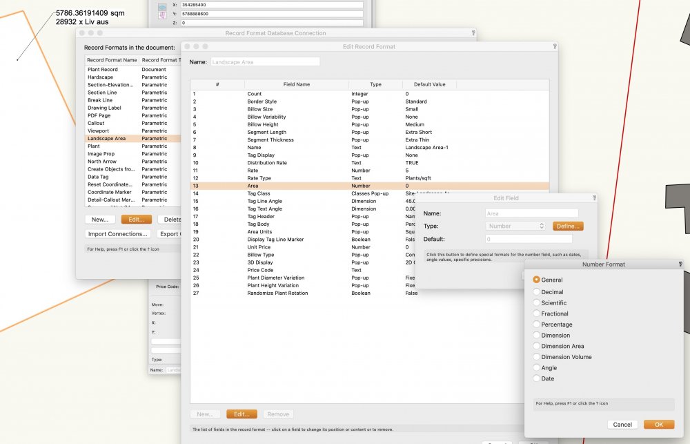
Hi all. I am still having trouble with decimal places on the data tag, especially with #Landscape Area#.#area# and plant quantity. The problem: Too many decimal places on a data tag. I want to get rid of all decimal places. Pretty obvious this is not governed by the overall units setting. I followed the solution in another thread (See below) to remove decimal places for plant quantity. But similar approach didn't work for #Landscape Area#.#area#. No matter which Number Format I choose, the decimal places remain on the data tag. Any idea?

-
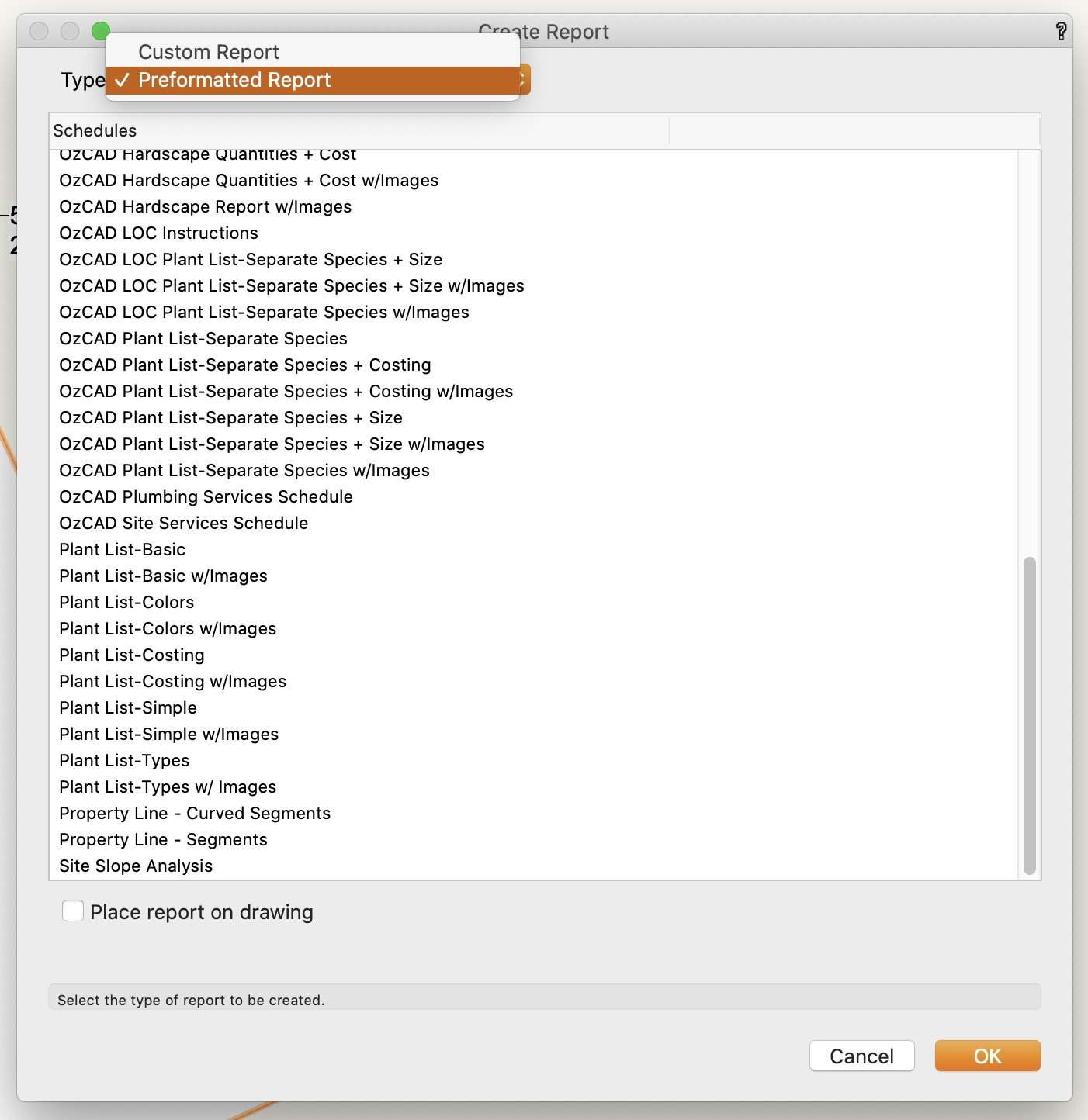
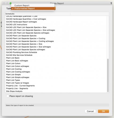
It got moved recently. Go to Tools>Reports>Create Reports..., at the dropdown menu select Preformatted Report. The plant lists should be there.
- 1 reply
-
- 1
-

-
Follow up: The bug comes back every time I open the same file again and make changes.
-
Want to report that the VW2020 OZ(Australian) SP3.1 version still has the same issue with plant quantity data tag showing two decimal places. Edgar's method solved it.
-
Sorry didn't mean to be pushy, I am simply at Australian time. Thanks Tamsin, hope all at Vectorworks UK are safe and sound. Looking forward to the training now we have all the time in the world!
-
Hi Tamsin, any chance that your GIS: Combining Geographic Coordinate and CAD Data webinar will be uploaded to the VWU any time soon? Thanks.
-
As a landscape architect I am glad that VW is reworking the geo-referencing functionality. Like Lisagravy described above, we have been using the XY coordinates as Northings and Eastings for more than 10 years. It has been working for us to a certain extent, except for the mysterious need to reset the user origin once in a while in order to import CAD files correctly again. We have never used the "old" Geo-referencing Tool. On VW2020, while I change the geographic location around with the Geolocate Tool, the value on the Coordinate Marker doesn't seem to change. Is this "new" GIS workflow a separate entity to the XY coordinates? If so, you can imagine it is quite a big change for us and there is a lot of uncertainty around the impact it might have on how we issue dwg for construction. I am a competent GIS user myself but I am as confused as my colleagues. A workflow video, or a simple diagrammatic explanation on how all these systems fit together, would be great.
-
Problem with VW Cloud My Presentations and panorama
twaikin replied to twaikin's question in Troubleshooting
Thanks! It is working now. -
Problem with VW Cloud My Presentations and panorama
twaikin replied to twaikin's question in Troubleshooting
Glad to hear others are also trying to use this. I found out subsequently that there are many other free virtual tour apps out there. This video might help with your presentations. Of course, I do hope VW further develops in-house VR capability in the future. It is still a bit buggy on a VR headset, but that's for another thread. -
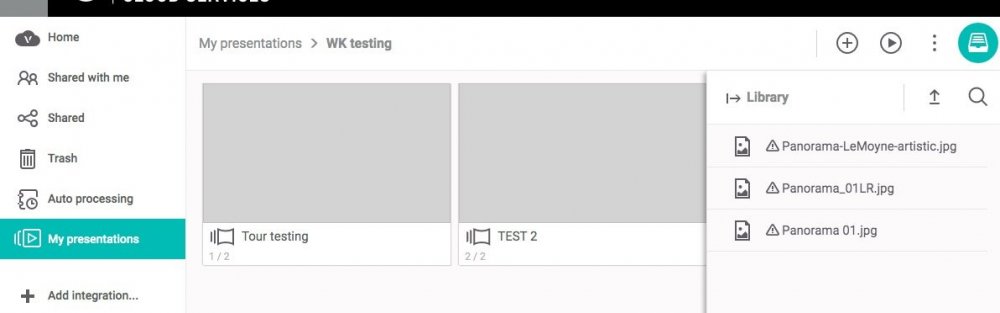
I am trying to create a tour in Vectorworks Cloud Services, using panoramas I generated locally. The panorama files failed to upload under multiple tests. If I drag and drop them, the file stays loading forever (see screenshot below). If I load them into the library, this triangle hazard symbol appears. I uploaded locally generated panoramas and even re-uploaded panoramas from the sample package. Same result. Other non-panorama jpg uploads fine. All these panoramas upload and sync fine onto the home folder too. Just having trouble uploading them to a presentation. Any idea?

-
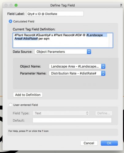
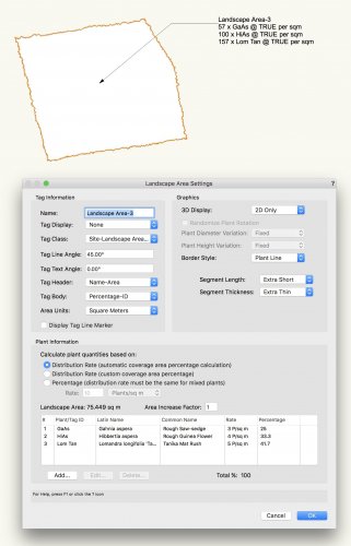
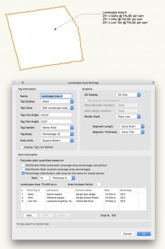
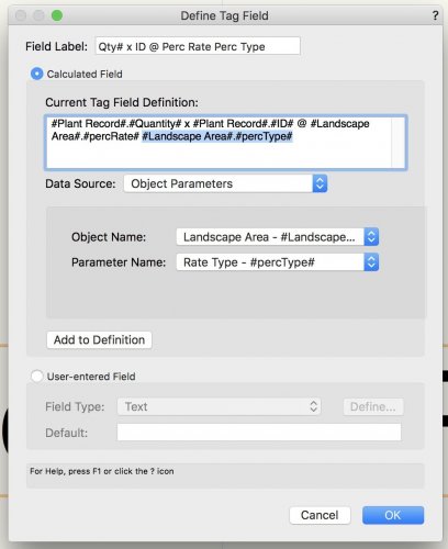
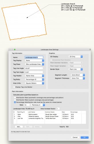
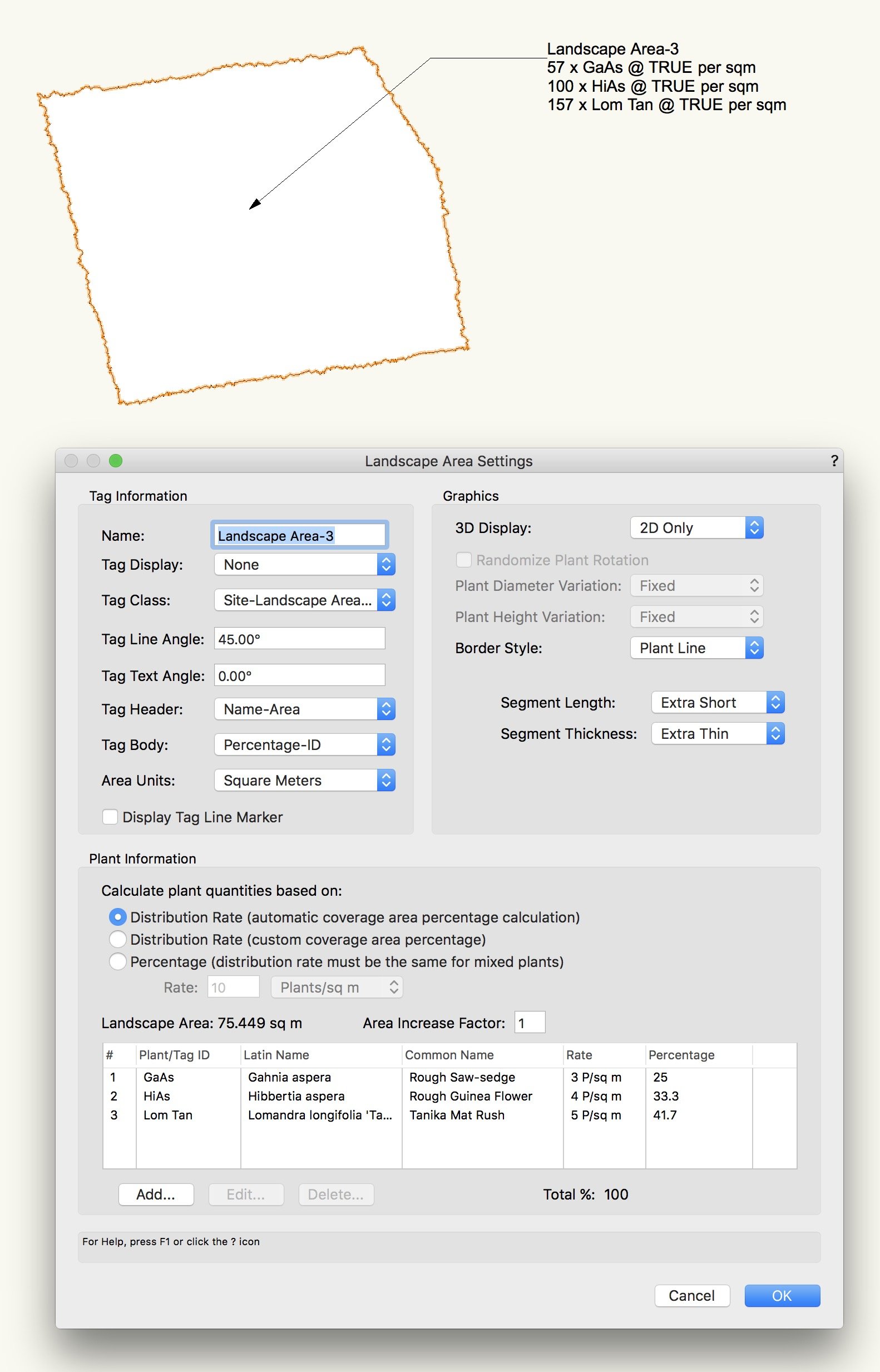
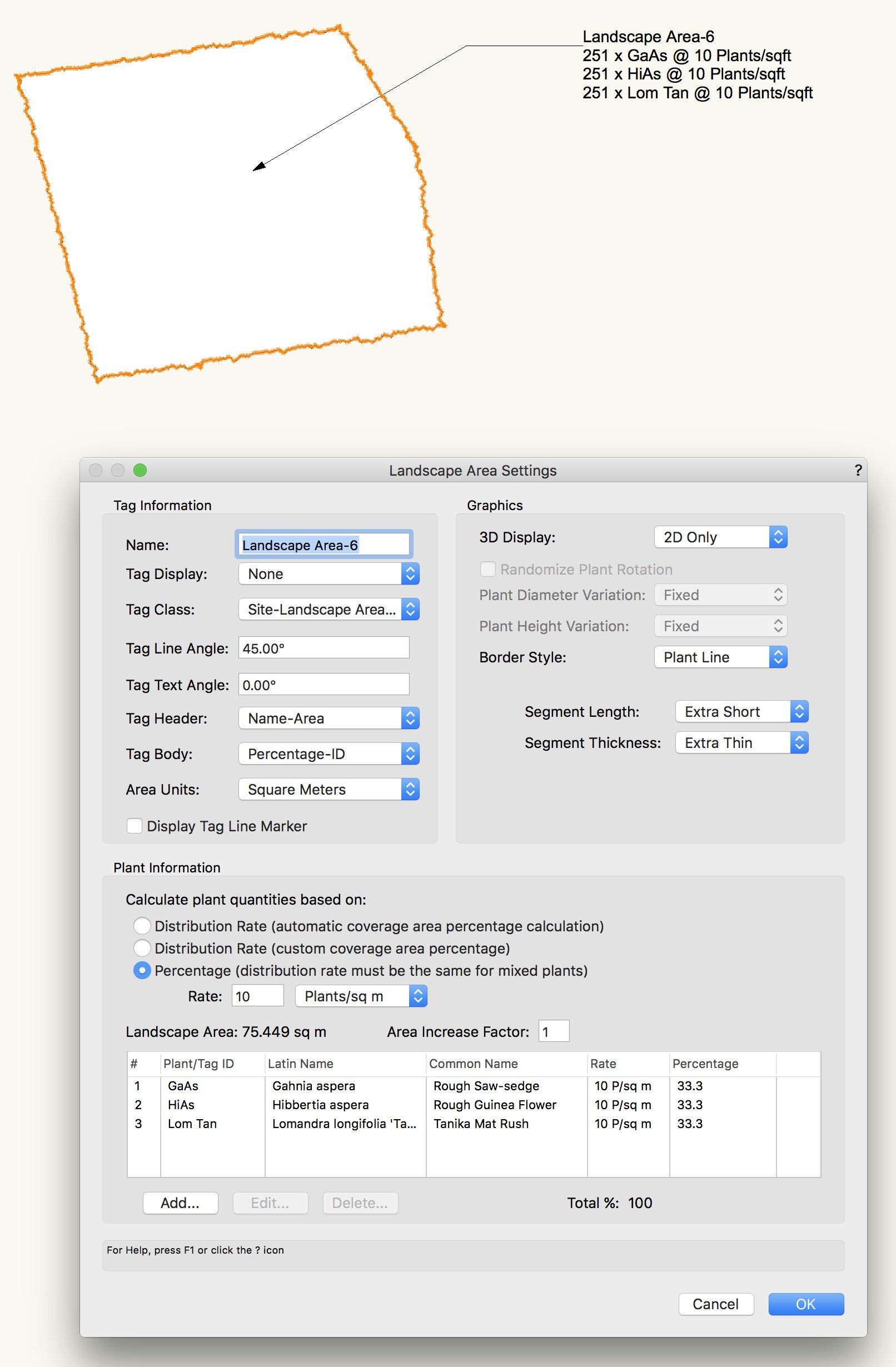
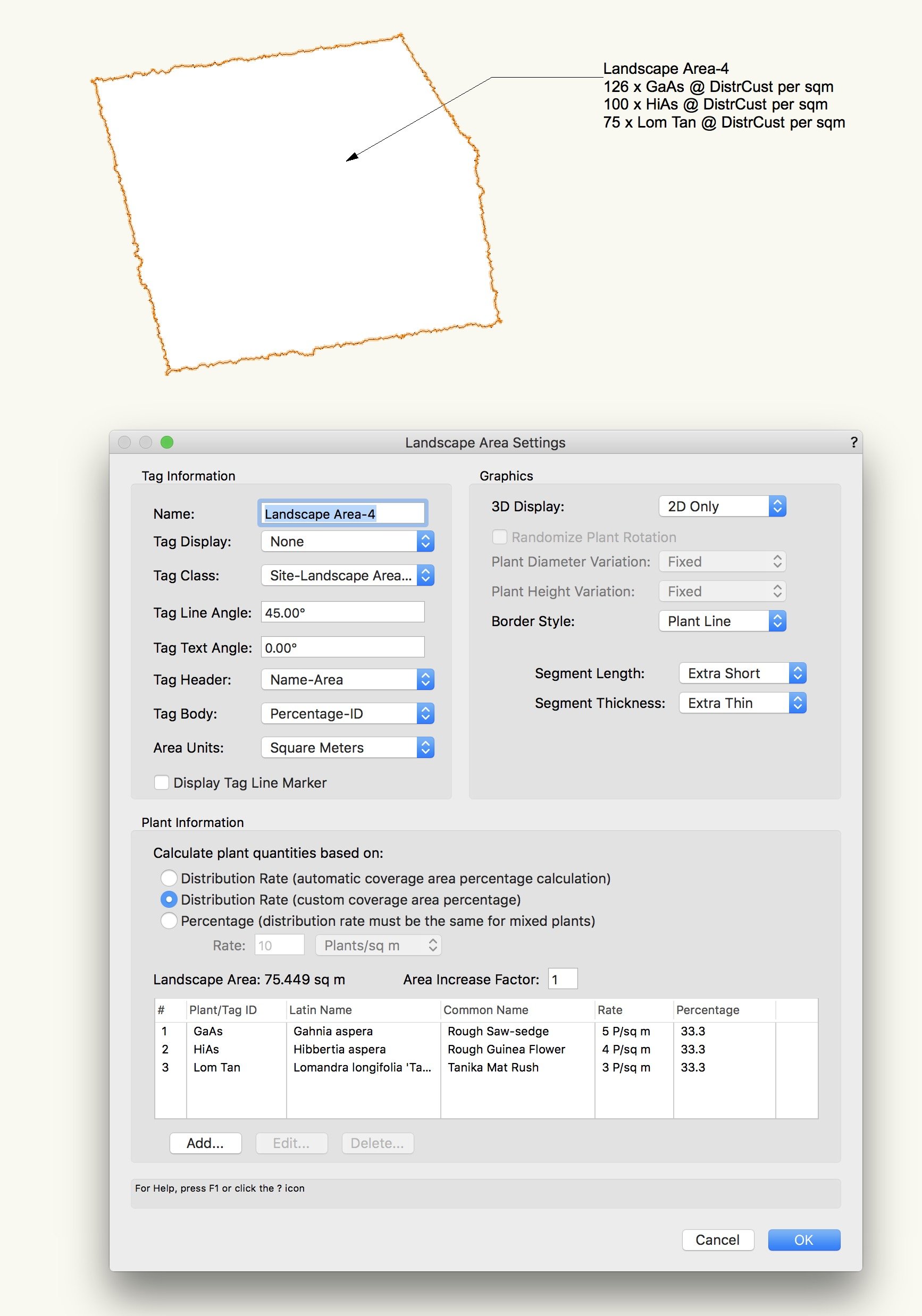
Hi, I found two landscape area-related data tag bugs. Is this the place to report it? Dynamic Text Bug 1: #Landscape Area#.#distRate# is returning TRUE, DistrCust or FALSE instead of the actual distribution rate of each species. See below Tag field window and Landscape Area 3 to 5. Dynamic Text Bug 2: #Landscape Area#.#percType# is giving me Plants/sqft instead of Plants/sqm, while area unit (and all other settings) is set to Square Meters. See below: #Landscape Area#.#percRate# is working fine (see Landscape Area-6 above) but it is not so useful for us because our planting rates vary within and across landscape areas.