Search the Community
Showing results for tags 'landscape'.
-
'Proposed Contours' not working as expected in Site Model
nicovlogg posted a question in Troubleshooting
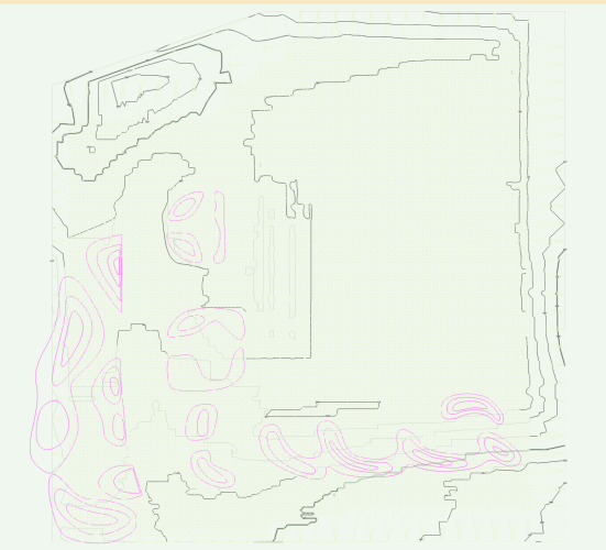
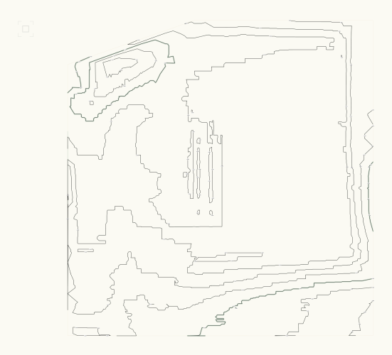
Hi all, I'm working with the 3D site model tools for the first time. I've gone through tutorials pretty extensively but haven't been able to find a solution to this issue. I have an existing site model, provided by the client. I'm attempting to model some new berms and swales on this model. When I add these in 'Proposed Contours', the model does not change. My view is set to show 'proposed' so it's not a phasing issue. Would appreciate any help. I can use the 'validate 3D data' tool and get an error, but there is nothing useful about a message that says 'something is wrong' - I need to know what it is. There are no overlapping lines that I can find. Existing contours Proposed contours - new in pink- 12 replies
-
- site model
- proposed
-
(and 3 more)
Tagged with:
-
Right now the stake tool required you to click in the elevation box, enter your elevation then place the stake. I know it does not seems like much but going back and forth to the elevation box then the drawing can be strenuous when entering hundreds of points manually. Having the possibility of a pop up box allowing to enter the next elevation after each stake being placed would be a nice and simple addition. Or Just being able to hit the Tab key to enter the elevation box maybe. Just something that give the possibility to skip going to click in that tiny elevation box would be nice. Thank you kind developing team
-
- stake tool
- landscape
-
(and 1 more)
Tagged with:
-
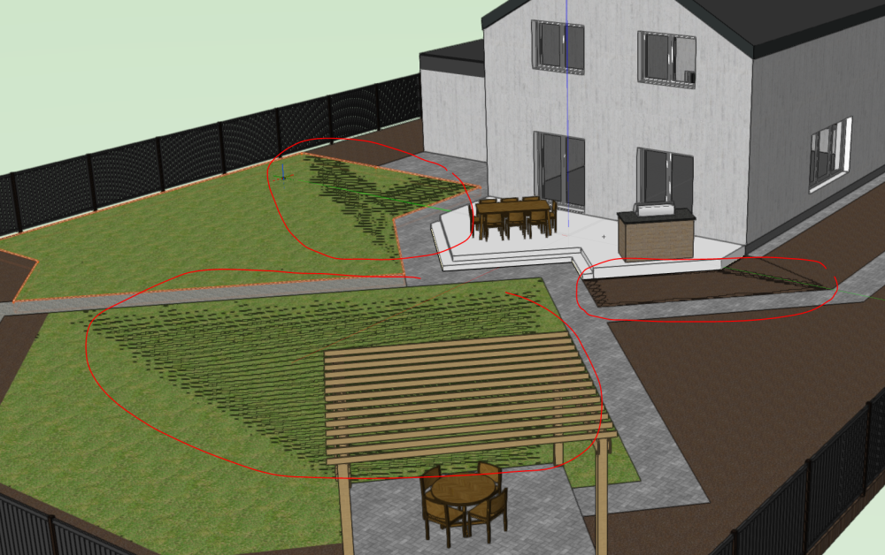
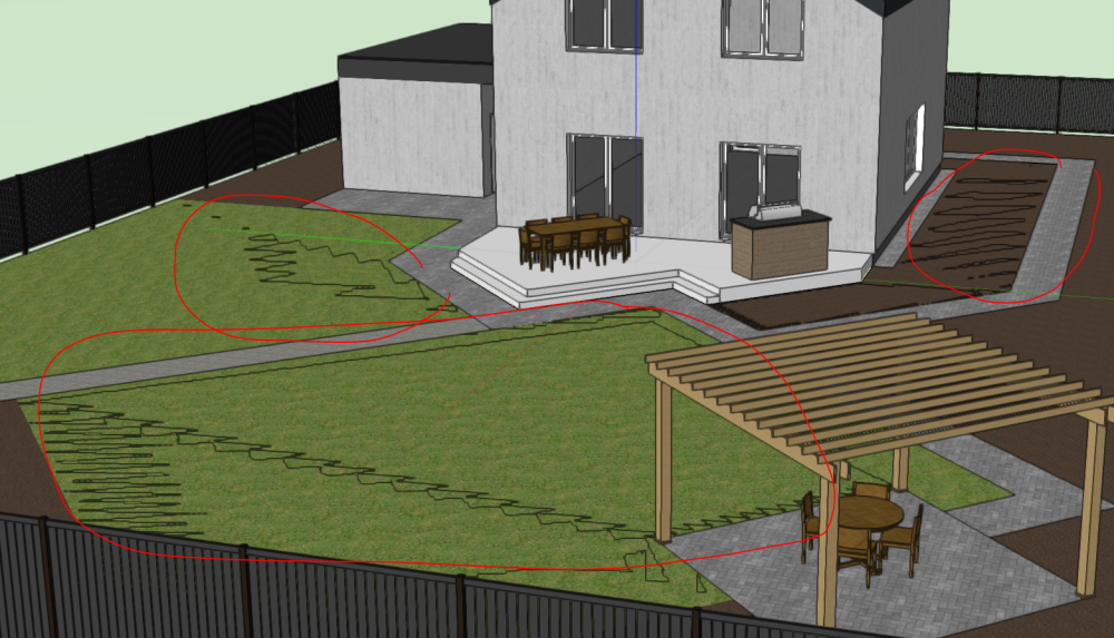
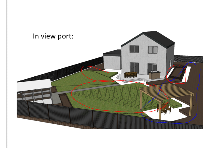
Hi, may be someone knows a reason why landscape area surface in 3D view flickers? When I move a view in 3D these black flickering spots getting bigger or smaller. They are also visible in view port. See pictures below. Previously I thought my PC was too weak, but recently I started using PC with recommended system requirements. Still the same. Site model is just around origin, no objects far from it. I noted also that this happens not to all areas, but I can not find a difference what may cause it. Any thoughts and recommendations here? 🙂 One more problem just appeared 🙂 Hardscape object (walkway) disappeared in viewport when I was creating it to illustrate flickering problem, see picture below. A class and a layer where walkway belongs are set to visible in viewport. Any thoughts why it disappears?
-
I am trying to streamline the documentation process for designed plant communities for both installation and visualizing with clients (along with my own forgetfulness). I have a resource drawing that I keep for plant objects with records attached that describes the varying interest season-to-season. I am experimenting with pulling these object styles for use with landscape areas, then using data visualization to show floral, foliage interest for a given season. This works with individual plants but not plants nested inside a landscape area style. Do landscape area styles retain records for plant styles attached to them? If so, should they show up in a data visualization with the records attached? I will try to clean up a test drawing and post on Monday. Cheers PWF
-
Can anybody point me in the direction of some relevant info on site models and site model snapshots. I have a site model drawn for a steep sight. I have used a site modifier tool to show a flattened area. Now I need to show two viewports, one with the existing contours, one with the proposed contours. I set the site models 3D display to existing then clicked Create snapshot. I then placed this snapshot on a class "site model 2". I then changed the actual site model 3D display back to proposed. The site model is on class "site model 1". In a viewport I would expect that if I turned one or the other class on I would see the existing or the proposed. I can only see the proposed. If I have the class site model 2 on, no site shows. Also when I go back to the Design Layer the site model and snapshot are not aligned. How should I be setting these objects up so that I can show both existing and proposed site models in two different viewports.
-
Version 1.0.0
85 downloads
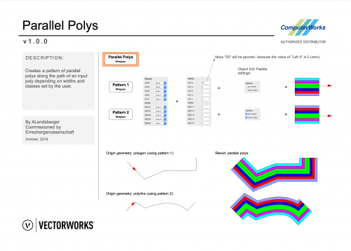
Creates a pattern of parallel polys along the path of an input poly depending on widths and classes set by the user. Erzeugt ein Muster paralleler Polys entlang eines Polys in Abhängigkeit der vom Nutzer festgelegten Breiten und Klassen. By ComputerWorks GmbH. Compatibility: Vectorworks 2020 and higher. -
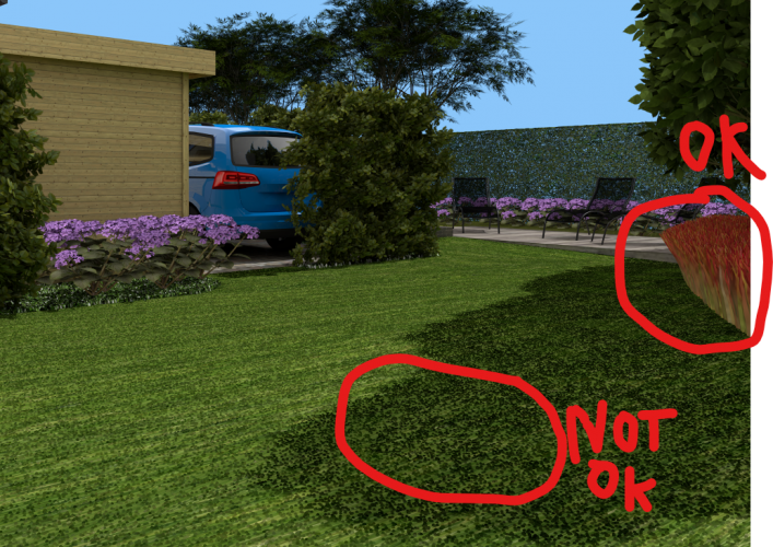
Hello, In some files, when I apply a grass texture on a polyline, the grass appears under the polyline. Not all grass texture because some of them are good. Sometimes, on my PC everything is ok and with the same file on vectorworks Cloud, it send me a pdf file with errors, see image bellow... On the image we see the "roots" of each grass. Is somebody have the same problem?
- 19 replies
-
- grass shader
- rendering error
-
(and 1 more)
Tagged with:
-
I have used Vectorworks for years (for landscape architecture), but have just started to learn 3D Vectorworks and I am struggling! Hardscape tool. I understand how to draw a hardscape and I can set the level at one point and then set a gradient across the area. But what about if the hardscape has more complex levels? Not just a simple fall? For example it might be a patio which comes out from a building level at FFL but falls slightly steeper at one side from the other to match up with existing ground levels on the other side. Can I set individual levels for each corner of the hardscape area? Which is what I would do on as notes on a standard 2D drawing? Custom Kerb tool. I need to extend an existing parking area. I have used the custom kerb tool to draw the area and have made it the correct shape with kerbs on the sides that need kerbs and no kerb where it meets the existing car park surfacing. But can I set this area to varied levels. As above, I would like to be able to set individual levels in each corner. The existing car park is not level and does not fall evenly across it so I need to be able to match up with this. Is this possible?? Thanks,
-
Version 1.0.1
286 downloads
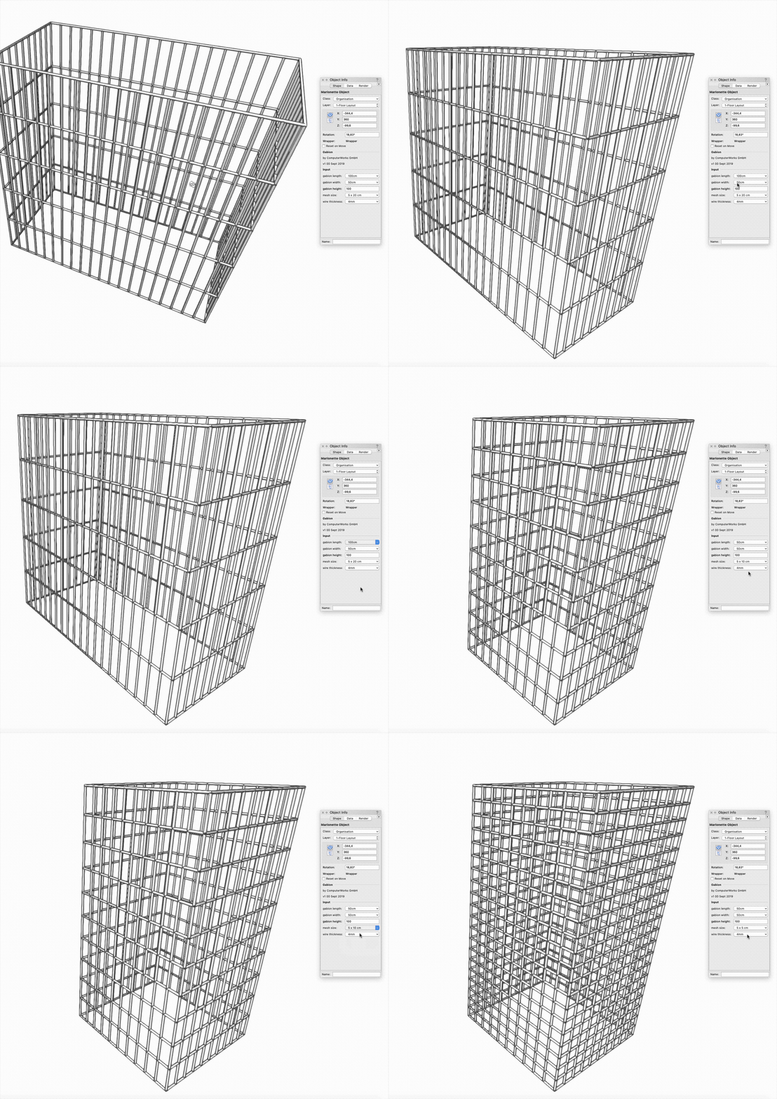
The Gabion is a parametric Marionette Object, that can be setup in dimensions, mesh size and wire thickness. Die Gabione ist ein parametrisches Marionette-Objekt, das in Abmessung, Maschenweite und Drahtstärke eingestellt werden kann. Created by ComputerWorks GmbH. Compatibility: Vectorworks 2019 and higher -
Hello, is there any VW plugin available like Sketchup Placemaker, or Infraworks or something like Worldmashine to get any terrain/landscape map into VW!? Thank you and best regards Nik
-
Since the introduction of Project Sharing in VW2016 and many other features in VW, it seems like the company has made a decision of steering users to single file workflows. With that said, we haven't found a way yet to consolidate our complex and memory intensive referenced file workflow into a single file system...at least not practically. I'm curious to what credit VW gives to differing workflows when developing tools or looking at the big picture. While I love the idea of doing everything in one file, we face two large hurdles to practically implement this practice on some of our larger sites. These roadblocks are: File Size - Our work is often broken out into 3 different segments (layout/grading, planting, and irrigation); thus, we have created a separate file for each. We have created a referenced file workflow that combines each of the various files together to generate our documents (schematic, design development, construction document). On large projects it is not uncommon for any one file to top out at 1+ GB, and individually, this already puts a strain on our machines. I cannot imagine combining our files together will result in smaller or more manageable file sizes, so we really haven't even considered it. Layer Management - With our multiple files, each with their respective design and sheet layers, it is also equally hard to imagine combining all of this organization into one file without a better way to organize it. Take our irrigation files alone. Our practice is to put each individual irrigation design zone/station into its own respective design layer. We do this for a myriad of reasons, but mainly, it is just easier to track and document complex systems. That said, it isn't unheard of that some of our irrigation files will contain almost 100 design layers! Similarly, we have worked on projects that have 20 irrigation sheets, 20 hardscape/grading sheets, 20 detail sheets, and 20 planting sheets. If I put all of that information together in one file, there is no way to organize it. I imagine a simple hierarchical or folder system similar to how classes currently sort would help this exponentially. The main reason I bring this topic up is that I have noticed that many of the new features VW has pushed in the past few years are solely intended to function in a single file workflow, but immediately run into difficulties when using a referenced file approach that we currently employ. Take the new Titleblocks for example, or even the old Sheet Borders...how do I use the same titleblock in 3-4 different files while keeping the Project specific data constant and maintaining individual control of the Sheet specific data? Referenced symbol? Referenced Titleblock Style? This works great in theory, but you quickly realize that the Project based data, when changed in one referenced file, does not transfer to other referenced files. I would love to hear more about peoples experiences/struggles with their single file or referenced file workflows. How is it working for you? Cumbersome? Have it all worked out? What else needs to be done to make this practical?
-
Hi again, Has anybody ever had trouble with new roads on the proposed landscape/pads? whenever I update my site model, a pad with a newly created road reverts back to the existing site model? I cannot seem to get it to hold its new form while the road is present. Any advice would be really appreciated. Thank you!
-
I am wondering if there is a way to use a script to populate a worksheet with all of the Plant Plug-in objects that are located within a file's Resource Manager, but not necessarily placed in the drawing. Could this also be refined to populate the list with Plug-in Objects placed within a specific folder in the resource manager? Can the script mine the data of the plug-in object to list the latin name, common name, schedule size, etc. similar to a database worksheet does for objects placed in the drawing. Thanks.
-
Hello, I am hoping to get some help with a potential marionette script. I am a novice at marionette and have no idea if this is even possible, but basically I'm hoping to Create Plants from a very basic circle for all plants marked as Favorites in the Vectorworks Plant database. Additionally, it would be great if you could assign the Plant Definition's width, height, spacing, ID, etc. from information present in the database. I don't know if marionette can access outside database information and then put it in the right place within a Plant Definition. I actually don't even know if it is possible to create a plant from marionette. Thanks in advance for the help.
-

Site Model 2D vs 3D Visual Characteristics
ericjhberg posted a question in Wishlist - Feature and Content Requests
In addition to the several other wishlist items for site models, it would be awesome to have the ability to keep the fill color for the 2d site model to none and still have the ability to have the 3d site model fill solid. Currently, if no fill is assigned to the site model, despite any graphic over-rides set for its 3d properties (i.e. separate classes and properties), then the 3d site model will appear in wireframe, no matter what. The reason for this is because the 2d site model can be used for contours, which often needs to graphically appear above hardscape or flat work, turf, landscape areas etc in order to convey the grading concept...so you set it to no fill and it works beautifully...until you enter 3d and see a wireframe site model. Just another practical use of the tools that should be accomodated for.-
- 1
-

-
- site model
- landscape
-
(and 2 more)
Tagged with:
-
Submitted on behalf of a client. "I have multiple landscape areas containing the same plant mix throughout a site. I would like to add another plant to the mix without changing the attributes of the landscape areas, especially the tags as these are a lot of work to place on the drawing so they are not overlaying other important information. I have found so far the easiest way is to add the plant to one area and use the eyedropper tool to paste the attributes to other areas. the problem seems to be the plugin parameters that contain the updated plan info also contain the tag info and there is no way to isolate these so I can change the mix of plants without moving the tags. Let me know if there is a better way or please consider this for a future upgrade."
-
- eyedropper
- landscape
-
(and 2 more)
Tagged with:
-

Stake Objects - Prefix or Suffix
ericjhberg posted a question in Wishlist - Feature and Content Requests
This is a fairly simple request. Can a field be added to stake objects that would allow for the addition of a prefix or suffix. This would allow for more precise graphical communication of spot elevation types (i.e. FS, TW, TS, FL, etc.)? We ideally need this information to use stake objects as annotative tools for grading plans.- 2 replies
-
- landscape
- site model
-
(and 3 more)
Tagged with:

