Search the Community
Showing results for tags 'hardscape'.
Found 25 results
-
HI I am trying to build a sidewalk that will follow the grade of my DTM. I have created a polygon and converted it to a hardscape, selecting the draped function. However the hardscape remains above the site model and flat. Does anyone have any ideas? Thank you
-
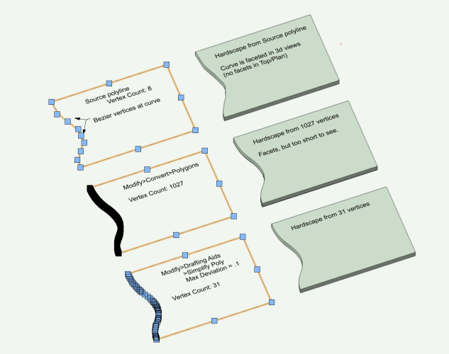
Hardscapes, and some other vwx objects, display faceted edges from smooth 2d source curves, eg bezier and spline. In the case of Hardscapes, Top Plan view does not show facets. But 3d views show a facet at each curve vertex. A workaround is to convert the source polyline (with curves) to a polygon. No curves, but probably lots of vertices which can slow down redraws and renders. Vertex count in this revised source can be reduced via Modify>Drafting Aids>Simplify Polys. Workaround is only a few steps, and helps the display at close zoom. But new edge is difficult to edit. Often easier to draw a new source polyline with bezier or spline points with subsequent and conversion and simplify. Big effort if lots of changes to several edges over design life. So save the original source poly! It might come in handy. Anyone have a better process? Example starts with 8 vertices. Convert to polygon produces 1027 vertices. Simplify Poly takes it down to 31. Facets nearly invisible at 31. But edits probalby best as do over. -B PS - this is not a 2d/3d conversion pref issue or render quality setting (both Very High), or layer raster resolution (300). Hardscape facets.vwx
-
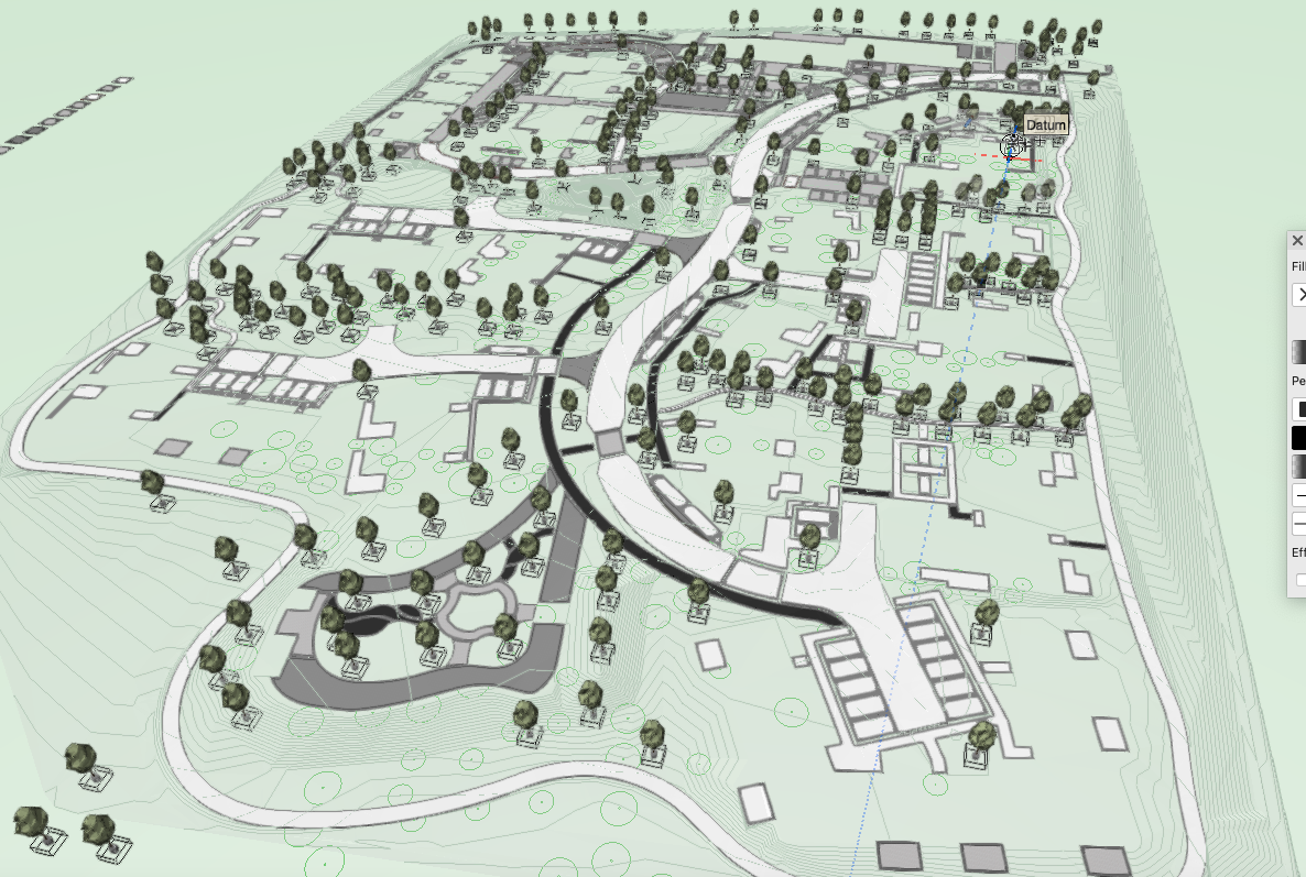
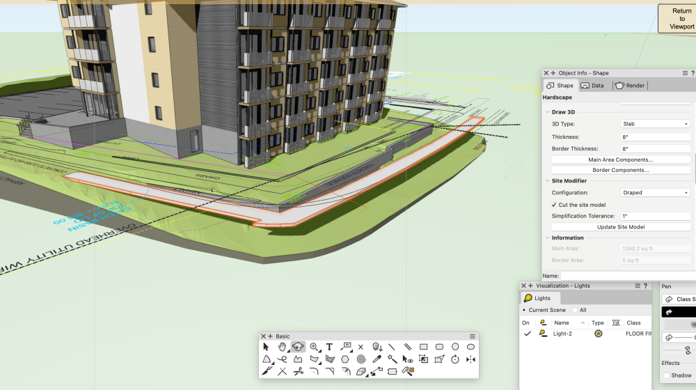
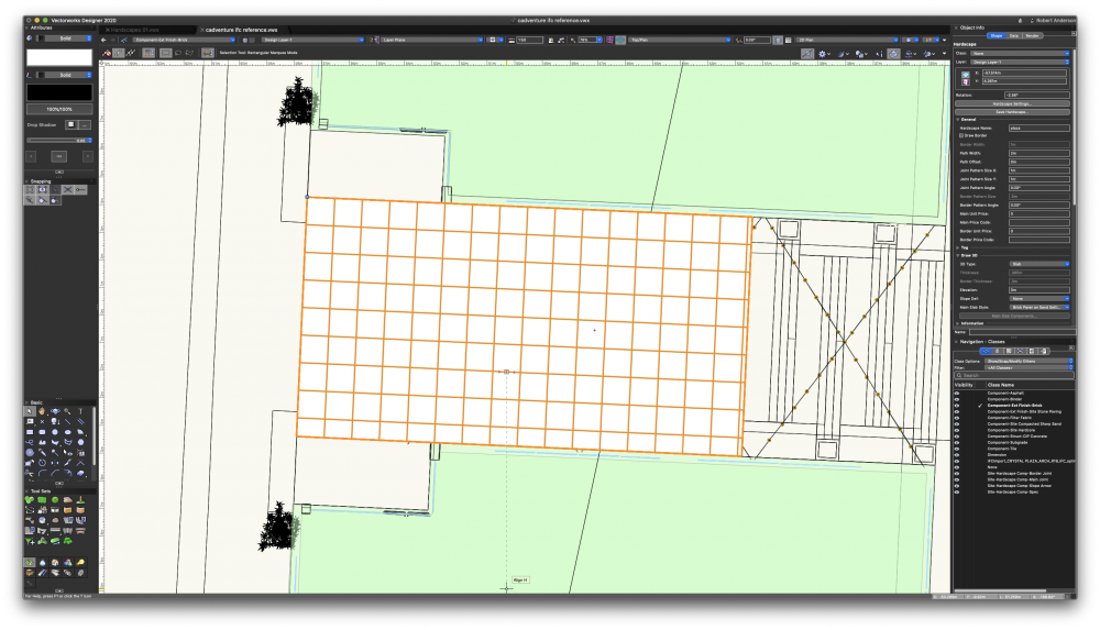
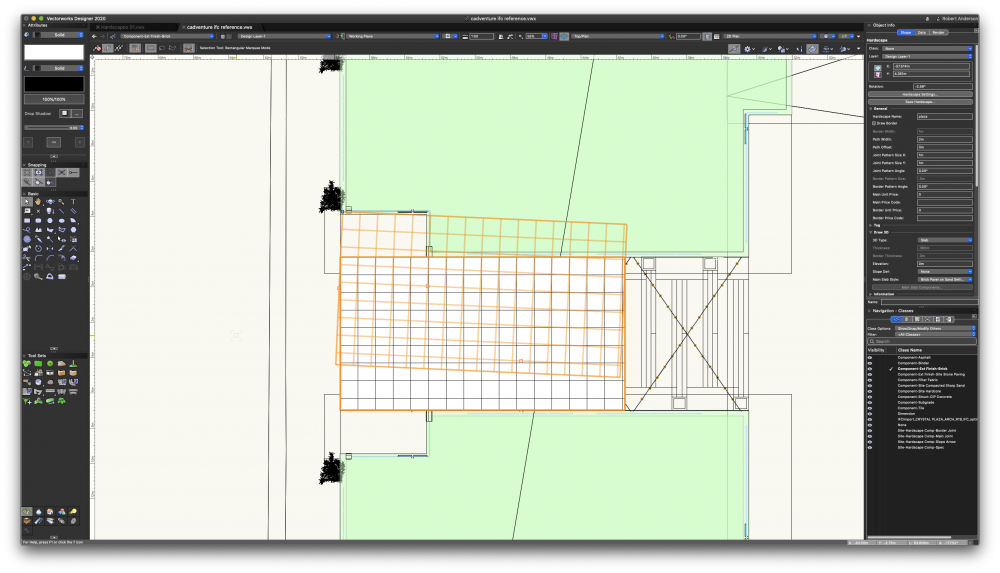
Hi All, We have a large scheme (in area rather than density). We have modelled the hard landscape using aligned hardscapes with site modifier stakes to get each hardscape to fall correctly with multi-directional falls. The site model will only update the proposed 3D topography if it is on the same layer as the hardscapes. When it does it displays too much moraying on the hardscapes to be useful. The hardscapes also do not cut the site model even when set to do so. Updating has no effect. Questions: Should I be able to choose a layer for the site model to align to? I thought this was a new feature but it doesn't work. I have followed this process but the model only aligns if on the same layer as hardscapes. Are there better, slicker, newer methods to create paved areas that can slope in multiple directions other than aligned hardscapes with stake modifiers? This method works well for us but aware things have changed a little in 2024. It takes a long time for the site model to update to align with the hardscapes. Is the model just too large an area with too many separate hardscapes? Screen grab below. Note the site model is not aligned in the screen grab. I have tried to split the site model into 4 to reduce load on VW but the edges don't meet cleanly where the cut in contours were made. Kind regards, Jack

-
Is there a way to have the hardscape border sit on the outside of the hardscape rather than inside the edge? Many thanks, Jack
-
I am trying to produce a 3D model of my 2D plan. I have decided to take the 2D polygon hatch areas and turn these into Hardscapes. This has worked, but when I look at them in flyover mode they are only in wire frame, not solid. I only want them as white blocks. I think it has something to do with what class they are in, but I am completely confused.... I changed the Site-DTM-Modifier class to a white fill and then they all come in as black. Which I don't want, I want them in white. Thank You
-
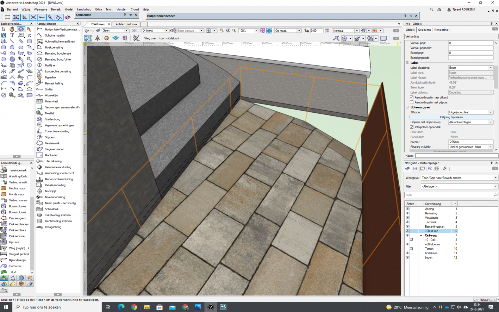
 Hi everyone, I have created a 'hardscape' element below in green with walls on the right. The 'hardscape' element is now aligning to the bottom of the wall with site modifier tool. How do I align the hardscape element to the top of of the wall instead of bottom? TIA for your help. Cheers, Nicole
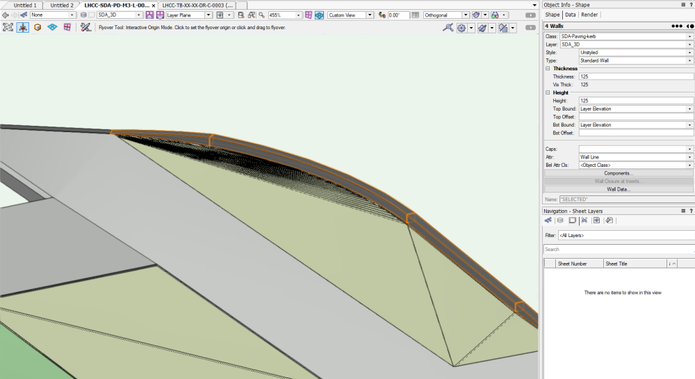
-
 Hardscape object set as “ site modifier ” can not be applied on existing terrain, only on purposed terrain, contrary to site modifiers objects which have the option so those site modifiers objects can be applied on existing OR purposed terrain. This option can be really useful sometimes. Even if there are really good enhancements to those tools in Vectorworks 2023, I think this option needs to be added. Do we have a chance that this could happen ? Thanks !
 -
 I've found that any Hardscape object created in Vectorworks Landmark 2021, which is set to 3D Type: Slab and has the Slab Components Datum set to Top of component (i.e. slab extruded downwards from the Hardscape object's elevation value), has zero thickness when the .vwx file is opened in Vectorworks Landmark 2022, and the Main Area Components and Border Components buttons of that hardscape object (which you'd use to correct/adjust the thickness) don't work in the Object Info Palette or the Hardscape Settings. When the buttons are clicked the usual settings box doesn't appear. I suspect this might have something to do with the fact that in VW 2021 the Top of component option causes the 3D slab thickness to be displayed in the OIP as a negative value, whereas in VW 2022 it is displayed as a positive value (despite still being a downward/negative extrusion). Has anyone else encountered this and found a solution? I've got some big files with large numbers of hardscapes set up this way, many of them inside symbols, and it would be excellent if an update to VW 2022 would allow them to be correctly translated to the new hardscape format, retaining their thickness and the ability to edit them.
 -

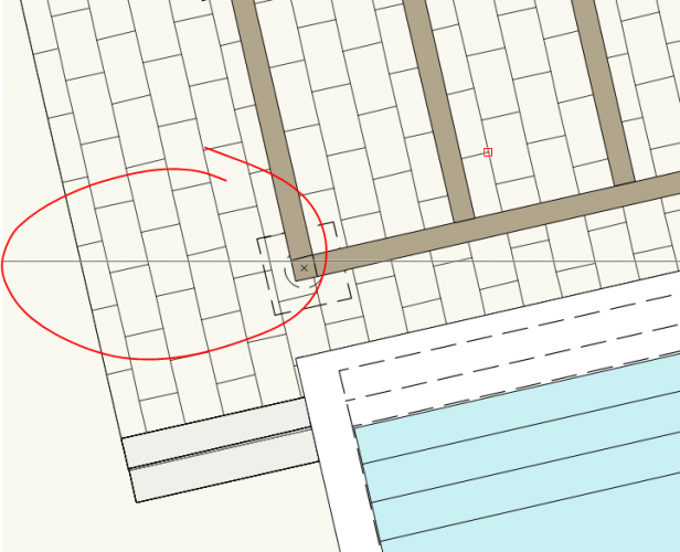
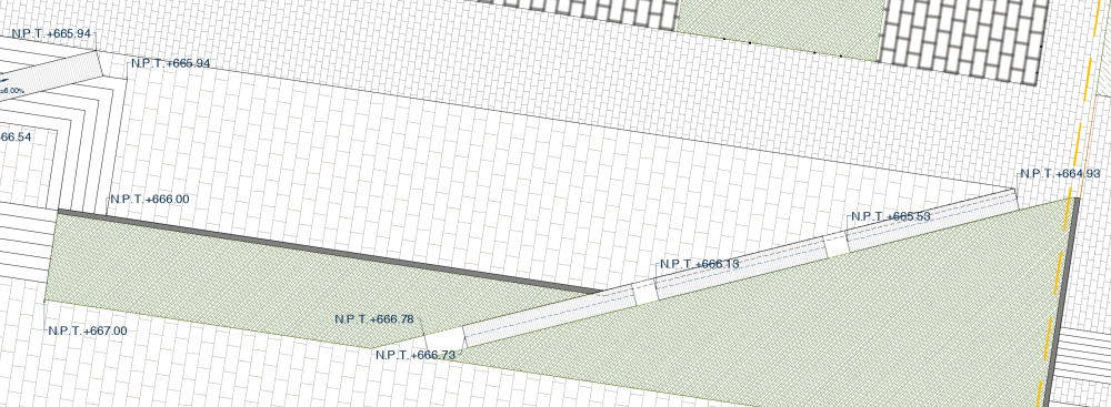
Why does my hardscape allign like this and how do I fix it?
Kokhoveniers posted a question in Troubleshooting
-
I often create individual paver units for a variety of reasons, it would be helpful to have the ability to "group" these individual hardscapes and grade them like a single hardscape. Some of the reasons for creating these "assemblies" is in order to apply records to individual pieces that are thicker at edges, or oversize, or custom cut.
-
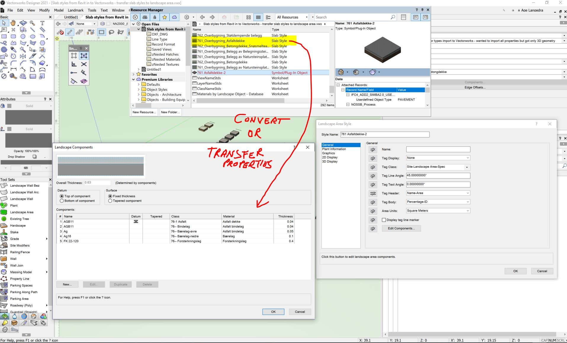
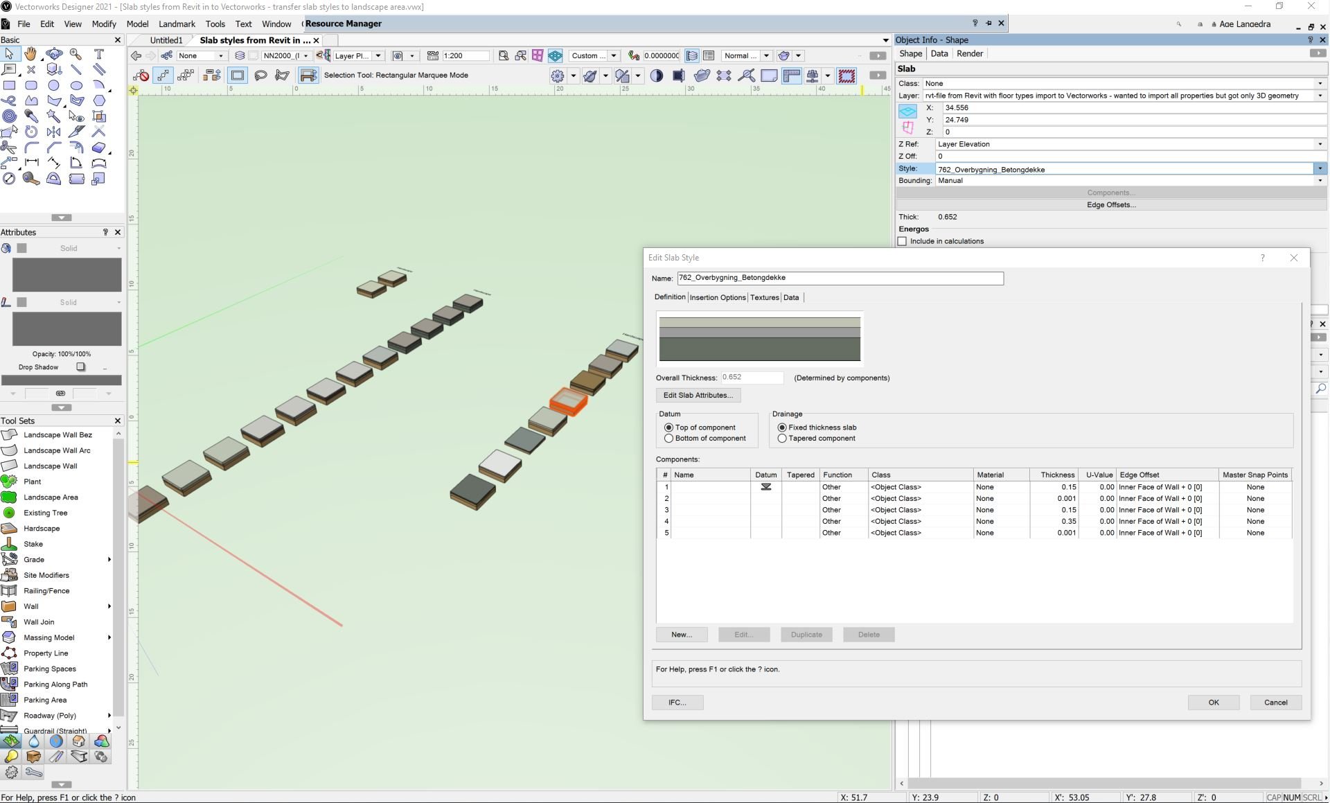
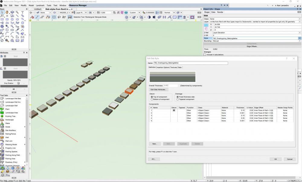
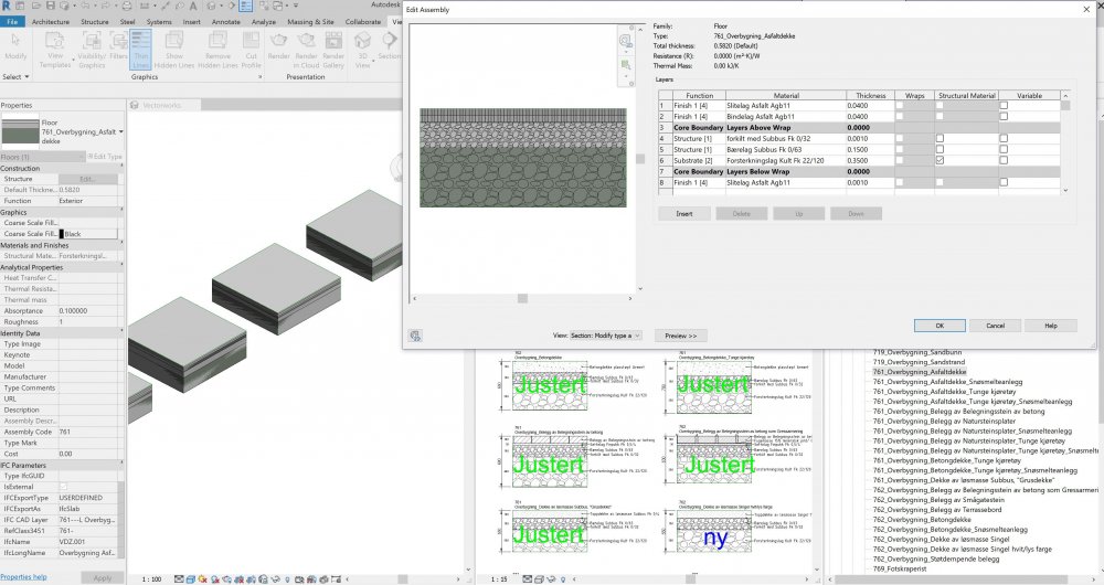
 In Revit I have dozens of "floor typs" / slab styles that I have imported to Vectorworks. In Vectorworks I have the opportunity to use both Hardscape and Landscape area. How can I transfer Vectorworks slab styles' components / layers with materials, thickness and preferably IFC properties to Landscape area's components? Is this possible? Is there a time-saving work around? Hope I can avoid going into building up all landscape area styles with countless components, names, class, materials, tickness, etc manually. Currently I only work with landscape area and not hardscape to save time in the project. We must also supply site model surfaces for machine control and for other disciplines. Therefore, we link all landscape area and landscape area used as hardscape to the same site model surface. Hoping for answers that can save me countless hours of work. Sorry the text in the model and drawing is in Norwegian, but I hope the issue is clear anyway.. Revit Floor types import to Vectorworks as Slab Styles_R2019.rvt Slab styles from Revit in to Vectorworks - transfer slab styles to landscape area.vwx
-
Hello community, Am trying to send to surface (site model) hardscape object using stake objects in hardscape surface modifier..but with no luck... How we can simply send to surface hardscape object as is possible with road object? I thougth it might be very easy to do this kind of operation with all of aligned slabs options but cant find the right steps to do so. Hope there is way to do this automatically without need to position stake objects individually that is case when site is quite uneven. Thanks.
-
I can't figure out why my hardscape isn't showing a fill, any Ideas? I've checked the class, checked the path, checked the material...
-
Hello, I am using VW21 and am trying to get the joint offset on a running bond to be 1/3rd instead of 1/2. I can't find any option to adjust the offset in hardscape settings. Does it exist? Thanks!
-
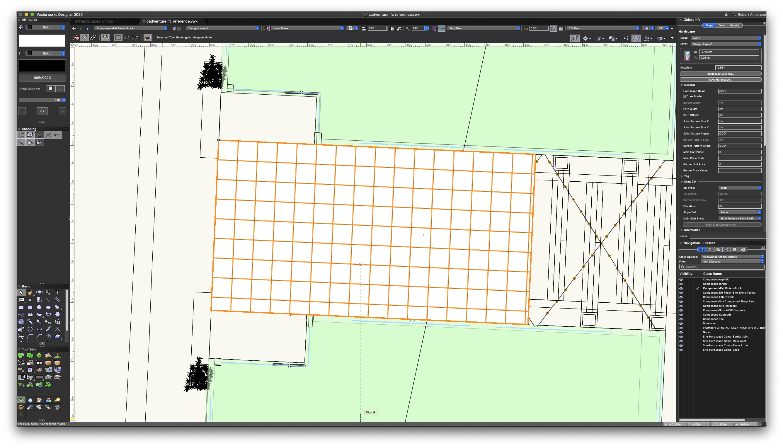
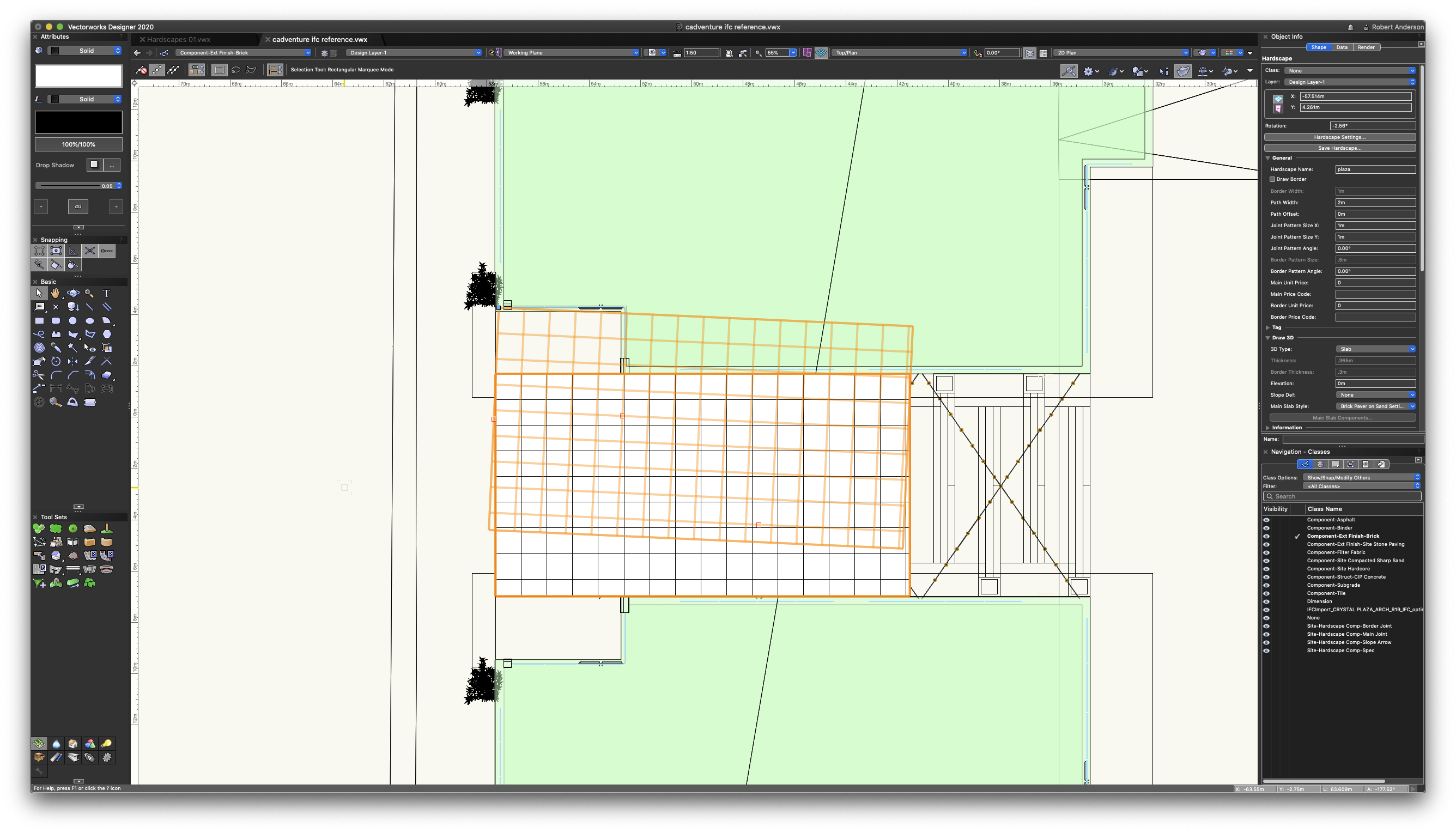
Fellow design junkies. I created this hardscape with a rotated plan so I could have my pattern parallel with the shape. When I went to open the file this morning I was greeted with this? Any time select the item i get the outline as it is in rotated top/plan. Yet when in top/plan everything appears normal. Had I not been noticing this all this time or is this a bug. It really is of no consequence as it would appear everything else works as advertised. Any thoughts or suggesting would be appreciated.
-
I've created a hardscape by boundary, due to varying width and form - though the hardscape is essentially intended to be a path, and I need to treat it as such in terms of levels. I know using the roadway / pathway settings you can edit each point on the path to set the level and crossfall... is there a way to do this with a boundary hardscape? Essentially I want to be able to input the edge levels along the route in 3D, and then potentially make this a modifier for my site model. Is the workflow for this to edit a base site model, placing stakes at the required chainages, and then set the hardscape as a texture bed only? I'd ideally like to set the levels within the hardscape itself, and keen to use the slab settings within the hardscape to allow detail sections. Any help much appreciated.
-
I am really missing the Landmark road planning improvements, so i can plan the roads a little more flexible directly on the site model (1) and so i can define the needed cross-section profile of the road side slopes etc. included. Today the different Site Model modifiers are useless, because the modifiers, which have at least some kind of hardscape profiles, are not really communicating with the Site Model. At the designed/modified site we usually don't have simple one direction slopes, like it could be done by the pad-modifier. Today i am able to work out a proper Site Model only by using simple 3D Polys, which takes to much time and then I can use only the Texture Bed Modifier, which can be usefull only for illustrating my Site, but is useless to have the hole hardscape layering embedded/glued to the Site model. Also really important, that the Paving etc hardscape according to the Site model can give the needed cross-section with the specified hardscape layers (for example: brick 60 mm, setting bed 40 mm, permeable base 150 mm, permeable subbased 200 mm) and that it has BIM support. Today I can export only the Site model without proper hardscapes (material underlayering included). Here is a good example from Revit (awfull background music should be muted): https://youtu.be/tw7_hLQo_H0 So far I understand, is also Revit not a specific road planning software, but still they have the compadibility for planning the roads a little more functional way, not just as a flat cross-section profile based way. This is clear, that i dont wait from vectorworks to have the 100% functionality of road planning software like for example Bentley Microstation has the InRoads software, but a little more functional tools are really missing. We have today 4 VW Landmark licenses, but our clients are more and more asking for a proper Site Model together with the paving etc. We and many other Landscape Architects are more and more in worry in that sense. Dont want to leave VectorWorks. Hoping for improvements in next Landmark tools.
-
Working on building a worksheet where clients and users will see the composition of the slab styles that will be used in Hardscapes. I've managed to create in the attached just such a thing but have run into a little difficulty. When using a function to get the thickness of a component it is adding all of the components regardless of which slab they are a part. The attached file has our slabs and the worksheet with the cells in question. My vulnerability is Worksheets and I'm learning more every day but I really could use some help on this one. Your time and effort is greatly appreciated! Have a great weekend! Slab Styles.vwx
-
Hello, I have a hardscape area with different "stakes" or spot elevations on each vertex. How do I model this? First time Vectorworks user.
-

Hardscapes and Landscape Areas - Styles
ericjhberg posted a question in Wishlist - Feature and Content Requests
It would be incredible if Hardscapes and Landscape Areas could be managed by Styles, similar to walls, roofs, slabs, titleblocks, etc. With this functionality, these would be saved as resources similar to Wall Styles, Roof Styles, Slab Styles, etc. and then could be edited in one location to make changes throughout the document. Currently the functionality of Save Hardscape... or Save Landscape Area... does create a resource manager resource, but that has no effect/connection to the instances located in the drawing. Furthermore, it really can't even be edited in the resource manager. Right now, the only way to enact large changes to multiple similar hardscapes is to make the changes to one and then use the match properties to apply it to all others. There are several reasons why this isn't ideal, Very Slow - Matching properties to hundreds of hardscapes or landscape areas can take forever to complete Inaccurate - The match properties workflow is a manual selection workflow and is only as precise as the users selection abilities/criteria It's time to rethink the way the Landmark tools fit within the greater movements of VW tools, I feel like they are out in their own little world and really should be brought into the fold. -
Hardscape - Aligning Render Textures
ericjhberg posted a question in Wishlist - Feature and Content Requests
Why is it that Hardscapes do not allow for alignment of Render Textures in similar ways to other solid objects (i.e. extrudes and floors). The entire Render Tab disappears when using Hardscape Objects. This is not good and should be fixed ASAP. -
How do you orient directional textures of Hardscape objects, or can this even be done? The Render Tab completely disappears on Hardscape objects, eliminating traditional render setting options like Auto-Align Plane/Follow Longest edge. This is one of the remaining headaches we have with Hardscapes.
-
Something I have been researching for a while and cannot find the answer is the creation of complex and easily created hardscapes, with the opportunity to have different elevations at each vertex. Much in the same way as you create a 3D polygon. One workflow might be: Create 3d polygon with different elevations at different vertexes > Create objects from shapes > Hardscapes Or Use stake tools to modify hardscapes in the same way they do a site model. This would improve the BIM workflow for Landmark immeasurably and move us on from simplistic modelling of external surfaces, to correct modelling which aligns with topographic information outside of our site and not under our control. Yes this can be created with site models but they cannot be utilised in the same way hardscapes can. Alternatively, If I have missed a trick here, please guide me in the right direction. Many Thanks,
- 4 replies
-
- 1
-

-
- hardscape
- site plans
- (and 2 more)
-
UN Create Objects from Shapes
ericjhberg posted a question in Wishlist - Feature and Content Requests
We often use the Create Objects From Shapes... tool to turn regular polys into plug-in objects like hardscapes, landscape areas, etc. Until recently (v2018) this would destroy curvilinear geometry, but now it doesn't. Great work. Now what we need is the ability, somehow, to run a Un-Create Objects from Shapes to go back to the original geometry from the plug-in created. There currently is no way to do this. You can use the Ungroup or Convert to Group commands, but this often results in way too many resulting objects. For example, a very basic hardscape, ungrouped, results in 3-4 identical shapes overlapping, which is impossible to get rid of on large projects. Just a thought. -
I’m not sure how most people generate 3D object, but in our office we turn 2D polygons, rectangles etc. in hardscapes, then in the Object Info, under 'Draw 3D’ Go: 3D type > Slab. Then from there you can edit slab thickness, elevation etc. In VW 2016 you were able to set negative thicknesses to the slab. For instance: say you have a step at a height of -600 elevation then you set the step thickness at -150. You know the top of the step is at a height of -600 below 0 and then another -150 down to the next step, starting the next step at an elevation of -750. In 2017 it seems you can’t set a slab thickness of less than 0 anymore. Meaning, if I use the same example, if I have a step with an elevation of -600 (this you can do in 2017) and enter a thickness, I have to enter 150 to get the same effect however the elevation of the step will be -450 now. The next step after this one will then need to be -750 at 150 thickness to give it a height of -600. Doing this for all 3D Hardscape-Slab objects in a drawing becomes incredibly confusing and makes us question our accuracy at every change therefor slowing production down to a grind... Could we have this changed back to the way it was? Cheers, Dan