MethodDesign
-
Posts
4 -
Joined
-
Last visited
-
Hi @Rebecca R, It looks like the data you downloaded includes a 1m resolution DTM in .tif format. You can use QGIS (open source GIS software) to extract a set of contour lines in .shp format from the DTM (Raster > Extraction > Contour..., choose DTM as input layer and specify contour interval in metres). The output .shp will contain two automatically generated data fields: a numeric ID for each contour, and an Elevation value. The .shp can be imported into Vectorworks, appearing as a set of 2D polys with an attached record format. You can then select the polys and use Tools > Records > Modify by Record... > Elevate 2D Polys to convert them to 3D polys as suggested by @Tom W.. (Make sure you set the Record Field to Elevation when doing this, otherwise it will interpret the unique numbers in the ID field as the elevation data, and the results will make no sense at all). You can then select the 3D polys and create a Site Model from Source Data... You'll probably want to experiment with the contour interval in QGIS to achieve the right balance of detail & file size. After creating the .shp you can also use Vector > Geoprocessing Tools > Clip... to crop the results down to a smaller coverage area. For this you'll need a separate .shp file containing a rectangle/polygon defining the Clip area, which you can create in Vectorworks or QGIS. After importing your contour .shp into Vectorworks you might also need to reduce the vertex count, using Modify > Drafting Aids > Simplify Polys... (before or after elevating the polys) so the resulting site model doesn't get too heavy and slow. If your drawing is set up and all files imported correctly in terms of Georeferencing, Origin etc., your site model will be at its true geographic scale and location, and the Use Geoimage Texture option in the Site Model Settings > 3D Display tab should work.
-
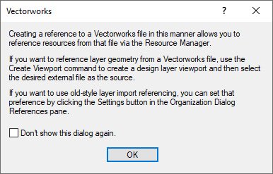
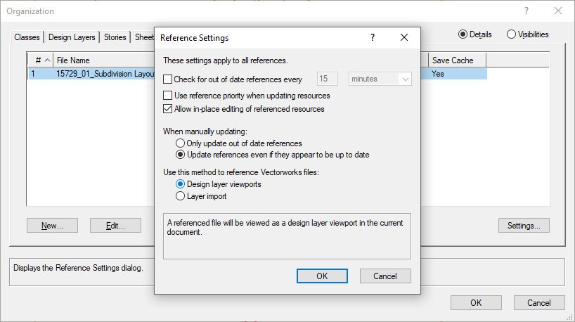
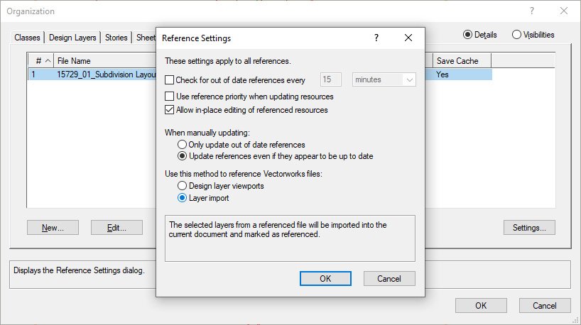
When creating a new file reference through the References tab of the Navigation Palette, a message box appears which begins with the following sentence: Creating a reference to a Vectorworks file in this manner allows you to reference resources from that file via the Resource Manager. After creating references in this way I haven't managed to find any resources from the referenced files in my resource browser, unless the 'old-style layer import referencing' referred to in the third sentence of the message box is activated, in which case all resources, classes and selected layers from the referenced file appear in the current file. I've tested this in Vectorworks Landmark 2022 and 2023 with the same result. Can anyone confirm how the creation of a reference to another Vectorworks file allows its resources to be viewed in the Resource Manager when the default Design layer viewports option is selected in the document's Reference Settings? or perhaps whether the first sentence in the create new reference message box is incorrect for this situation? This question has arisen during training sessions that I provide to local Vectorworks users, and I'd like to be able to provide a clear answer in future. I'm well aware of the Resource Browser's ability to browse other files and import resources from them, so this isn't a workflow problem for me. I've also noticed that the two options in the Reference Settings window under the heading Use this method to reference Vectorworks files:, affects not only .vwx file references, but also .dwg file references. I wonder if that heading would benefit from being updated to include all file types that the settings below it affect. Thanks in advance.
-
I've found that any Hardscape object created in Vectorworks Landmark 2021, which is set to 3D Type: Slab and has the Slab Components Datum set to Top of component (i.e. slab extruded downwards from the Hardscape object's elevation value), has zero thickness when the .vwx file is opened in Vectorworks Landmark 2022, and the Main Area Components and Border Components buttons of that hardscape object (which you'd use to correct/adjust the thickness) don't work in the Object Info Palette or the Hardscape Settings. When the buttons are clicked the usual settings box doesn't appear. I suspect this might have something to do with the fact that in VW 2021 the Top of component option causes the 3D slab thickness to be displayed in the OIP as a negative value, whereas in VW 2022 it is displayed as a positive value (despite still being a downward/negative extrusion). Has anyone else encountered this and found a solution? I've got some big files with large numbers of hardscapes set up this way, many of them inside symbols, and it would be excellent if an update to VW 2022 would allow them to be correctly translated to the new hardscape format, retaining their thickness and the ability to edit them.
-
Same problem here