Frederic_Vbc
-
Posts
38 -
Joined
-
Last visited
Content Type
Profiles
Forums
Events
Articles
Marionette
Store
Everything posted by Frederic_Vbc
-
Heights/spot elevations on site model/objects in section
Frederic_Vbc replied to Elin's topic in Workflows
@Elin Maybe try using 3D Stakes and Data Tag to get the elevation in your viewport- 10 replies
-
- 1
-

-
- spot elevation
- grade
- (and 2 more)
-
Is this really the performance one could expect?
Frederic_Vbc replied to MartinBlomberg's question in Troubleshooting
What I meant is when you have a perspective viewport and you open the edit panel, there is that option 'Camera' that you can use to modify your point of view (even when you didn't set up a camera.. I know it's a bit confusing). But as for your case it does look really painful ! Are you working in Open GL to move around ? Textures are the next suspect to check. I tend to move around in Wireframe if I ever use a camera. Very rare thing.. I usually don't even touch the camera or use the rendering tool of VW. The gap with Lumion or Twinmotion is just too big. VW is great for lots of things but rendering...Haha. I think they already gave up actually. No one can be good at everything I guess !
-
Is this really the performance one could expect?
Frederic_Vbc replied to MartinBlomberg's question in Troubleshooting
Well I've got the same results as you. The operation takes ~50s to perform. Looks like it's handled by only one CPU so hopefully this kind of operation will be improve in 2021 with performance enhancement on multi tread. Also you can reduce your waiting time by getting the right setting on a smaller sample of your curtain wall (or just one side). That's a lot less geometry to process -> much faster to perform. That's my best advice 😕 -
Is this really the performance one could expect?
Frederic_Vbc replied to MartinBlomberg's question in Troubleshooting
Can you share your file ? or just what we can see on that layer if there's some sensitive info. -
Is this really the performance one could expect?
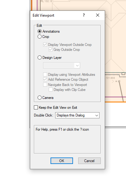
Frederic_Vbc replied to MartinBlomberg's question in Troubleshooting
Why editing your viewport point of view using crop and not camera ? My model does also lag if I edit the point of view with Edit/Crop but not at all when using Edit/Camera -
The viewport from the referenced file looks like a Wireframe Top view were the first one looks like a Top Plan View. Is your referenced viewport on a Design layer or Sheet Layer ? They're behaving differently accordingly. Are you trying to reference that viewport on a design Layer so you can make another viewport of that viewport to mix Top View(3D) and Plan View (2D)? (A viewport Inception 😛)
-
Same problem.. working on Win 10 (2020 sp4).
-
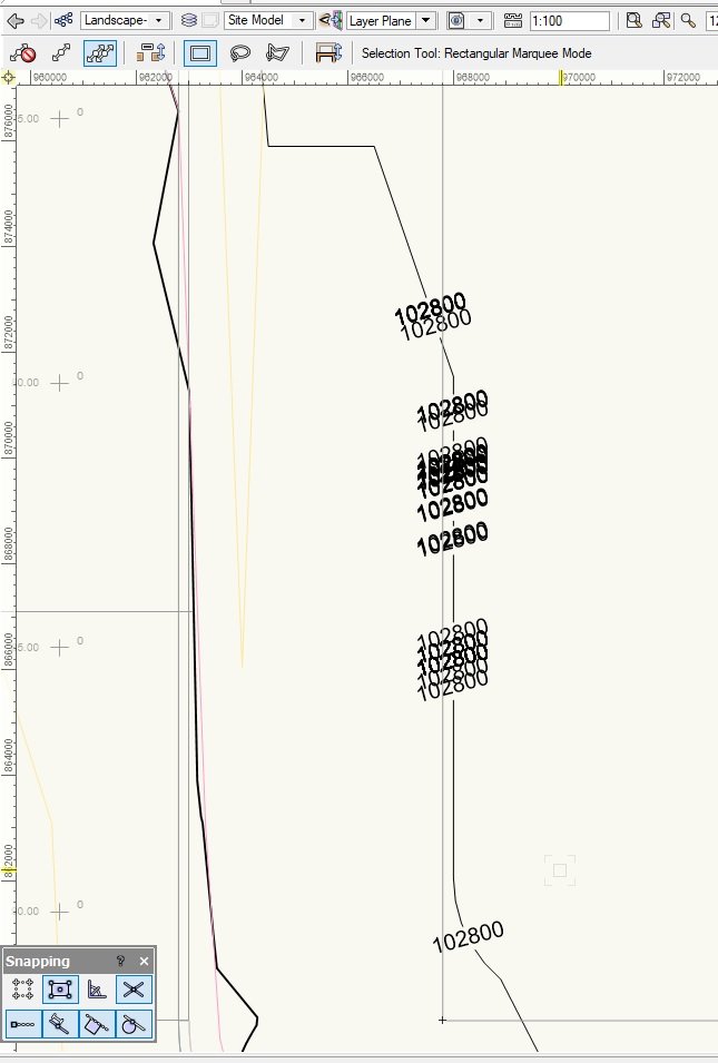
Duplicated contour line labels are a problem
Frederic_Vbc replied to Jeff Prince's topic in Site Design
@jeff prince I've finally been able to fix the issue ! Problem was coming from the source data... Even-though I thought I did a good job at having clean data input. Previous workflow Contour imported from surveyor Polyline simplified (50mm deviation) and converted to 3D poly Run 'Validate 3D data' to spot and fix eventual overlap Create site model from source Data Site model looks good and was fast to generate (good sign). Everything looks fine until issues with contour labels... BUT after careful analysis of source data it appeared that some 3D poly vertex were not on the same elevation (100mm difference, very hard to see, specially with hundreds of contour lines). Thus imported surveyor 3D data were the problem. Fix Convert 3D poly to contour lines (select all 3D poly/Landmark/Create object from shape/Site modifier/Contour). Leave elevation to 0. The faulty 3D poly will now appear as a contour (or pad) with a slope. select them all (Select similar Tool) and set slope to none. Convert the contour lines back to 3D poly. Now you have nice 3D poly with all vertex on same levels. This will be my typical workflow for now on as 'The Validate 3D Data' only is not enough. EDIT Problems are back. Playing with site modifiers and grading limit back and forth are causing contour labels to go crazy. And once it's started nothing can fix it (to my knowledge). Workaround Keep a copy of your site model (e.g. another layer, turned off). Save you Site Model settings. Once you are done with your Site Modifiers (and your contours labels are all messed up), use the 'original' copy to replace the messed up Site Model. Apply your saved setting and it should be fine now. (The problems start to appear when you play with modifiers back and forth. Not when initially applied) -
Same, Bring it forward (Ctrl+F) is my fix.
-
Duplicated contour line labels are a problem
Frederic_Vbc replied to Jeff Prince's topic in Site Design
Same problem as Jeff for the contour Labels stacking up. My Source Data are nice and clean 3D poly (Low vertex count and 3D Data Validated) Recreate from source data doesn't change anything D
-
@Boh I've experienced this issue a few time and found out it happened after installation of another software (Update of Evernote here). It's acting like if the other software was taking priority on the shortcut. Reloading the workspace fixed the issue for me...
-
Publish command is printing sheets in reverse order
Frederic_Vbc replied to TomKen's topic in General Discussion
I have the same problem. Impossible to print in the desire order tough because it reverse it automatically when I hit Publish button. Win 10 pro V2020 sp2 Australia. ( Btw this update is a nightmare, crash 10 times a day. I spend half of the day hitting Ctrl+S) -
Same problem here. Best fix I found yet is to apply a bubble style..