
MarcelP102
-
Posts
257 -
Joined
-
Last visited
Content Type
Profiles
Forums
Events
Articles
Marionette
Store
Everything posted by MarcelP102
-

Reshape tool not working on groups after updating to VW23
MarcelP102 replied to Daniel Monty's question in Troubleshooting
Also snapping to a loaded pdf it's geometry does not work in rotated plan view. At least for me in 2022. Weird that stuff breaks by simply rotating your view.. -
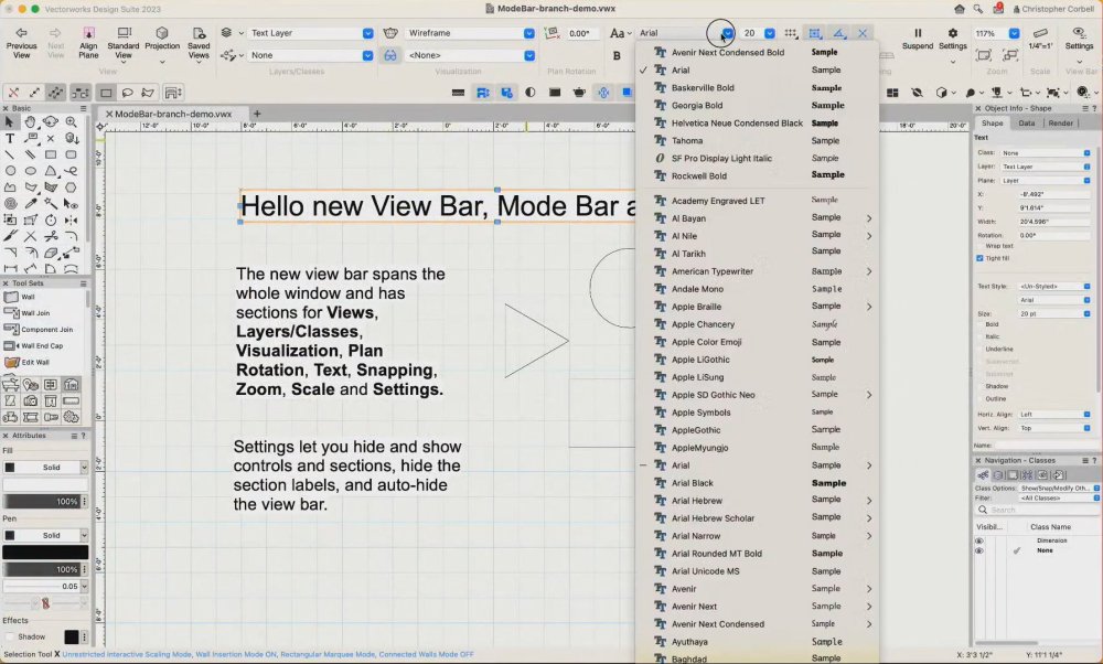
First thing I noticed when I saw the video's was the lack of the color slider. Every single app, even open source, has this. +1 from me to bring this back. While the color palette get's a second look it perhaps also nice to use the same drop-out style as the gradient settings menu. Right now it sticks next to the palette, doesn't look that nice IMHO. The nice thing about the gradient settings menu is that the arrow made it pop. Besides that the color palet is super big for me, using up the whole screen height..
-
Feature service seems to have an unwanted request limit of 2000 objects
MarcelP102 replied to MarcelP102's question in Troubleshooting
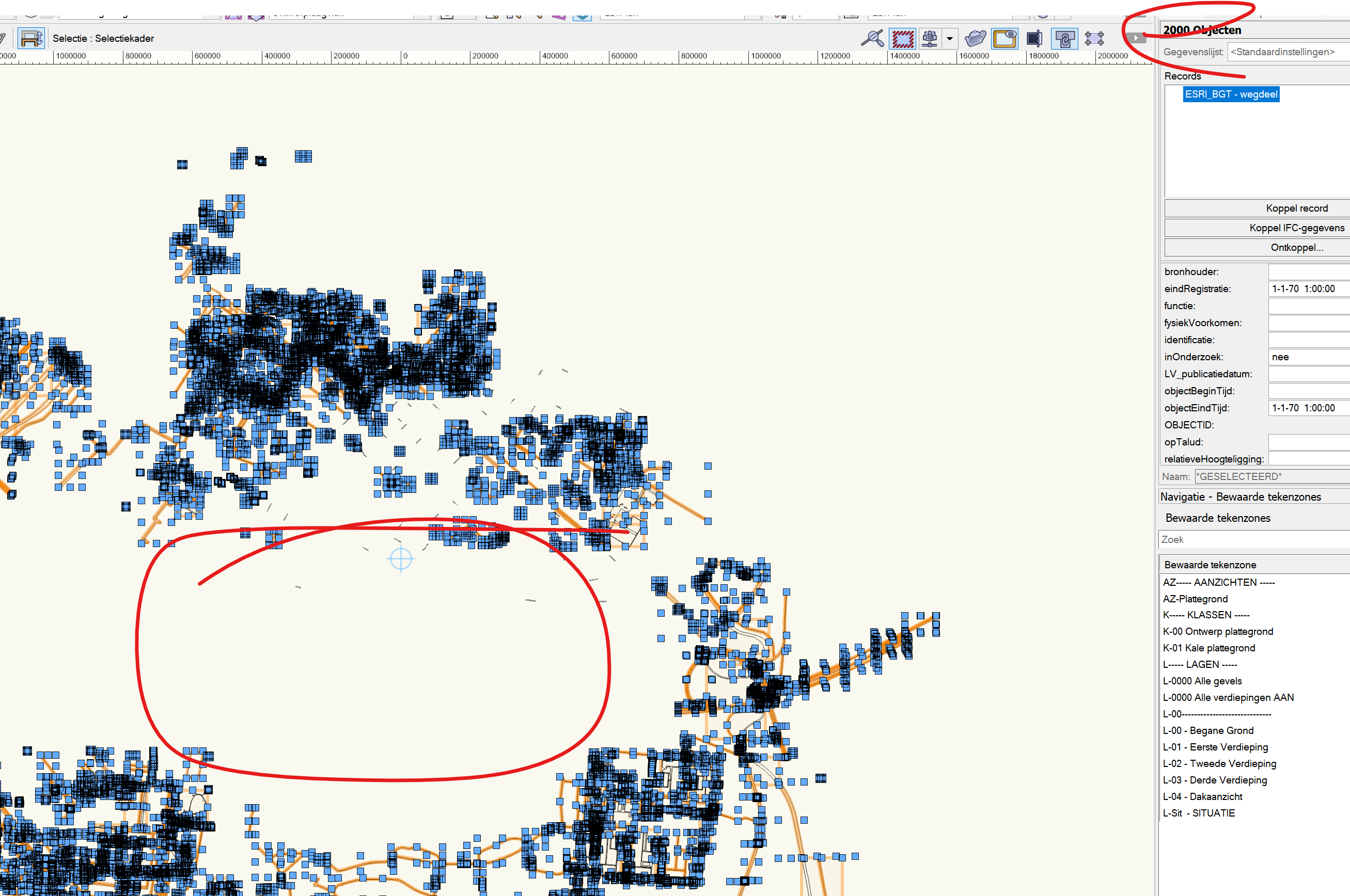
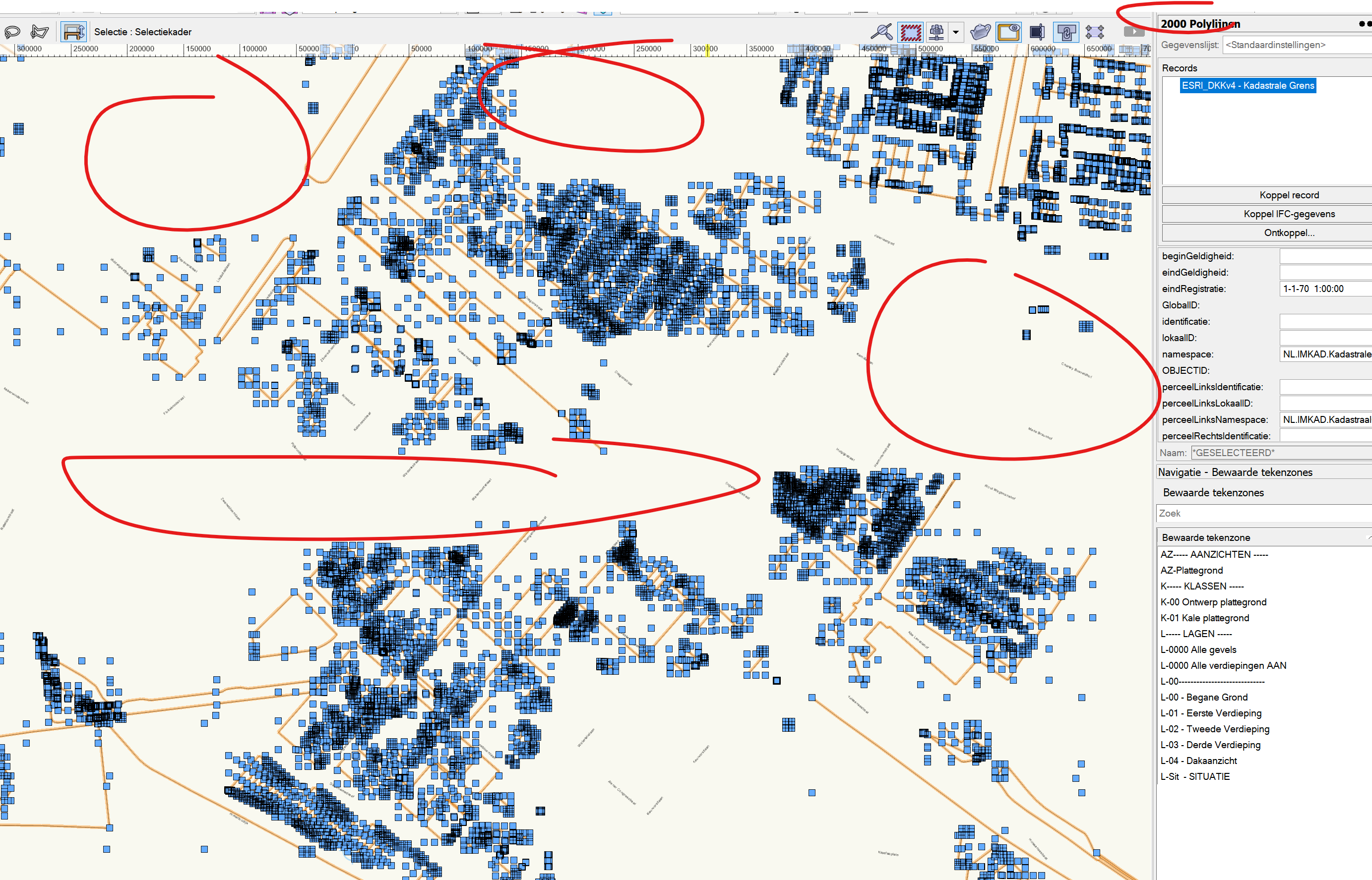
Hi @iborisov Designexpress (our local reseller of Vectorworks) has reached out to Esri. They told us you can program to first ask how many features there are in the 'area view'. And then load all the features in batches of 2000 until all features are returned. Also see here: https://developers.arcgis.com/rest/services-reference/enterprise/query-feature-service-layer-.htm We hope this can be implanted by a service pack. Right now the VW GIS feature is unreliable because you are never sure if all the features are download. We really want to skip QGIS and do all the GIS work in VW. This is the only thing that's holding us down for now. Thanks in advance -
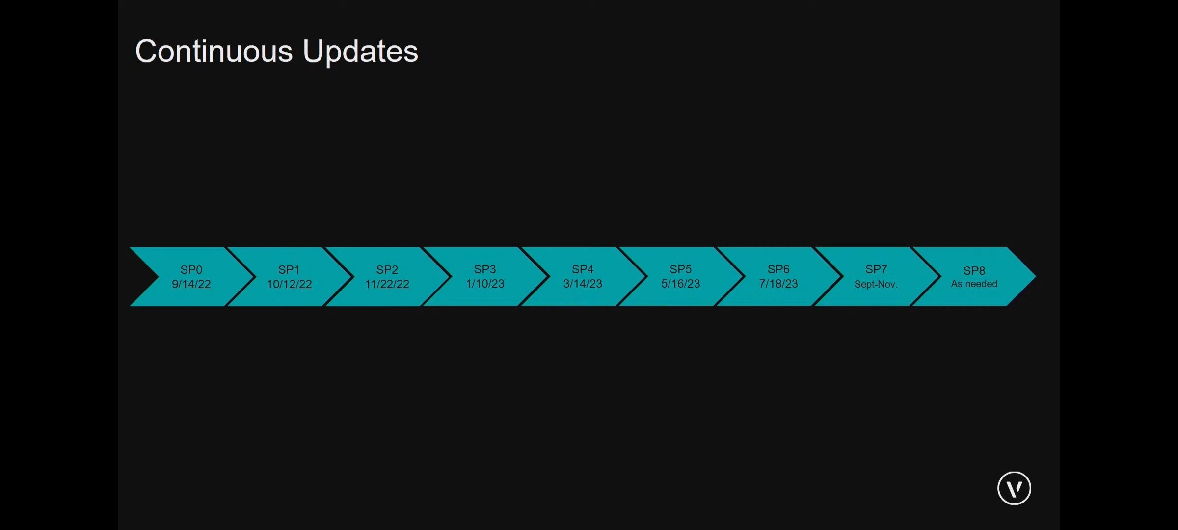
Vectorworks abandoning perpetual licences
MarcelP102 replied to line-weight's topic in General Discussion
Here is a screenshot of the new, more frequent, update cycle as showed in the last Vectorworks Design Day: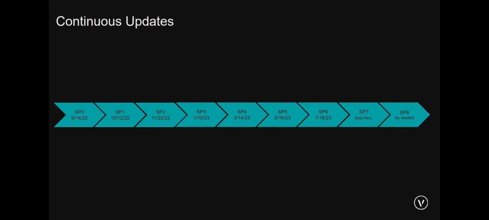
-
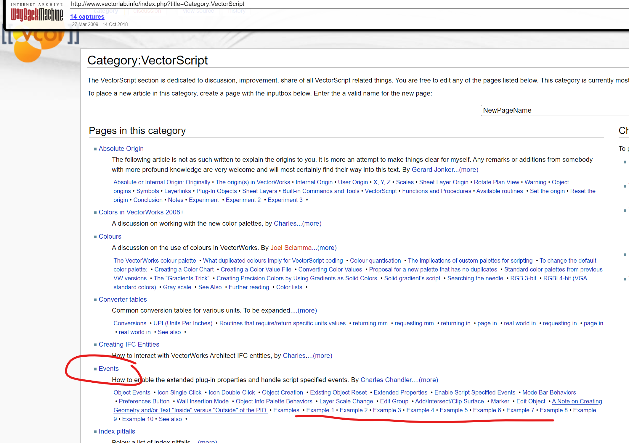
Does anybody know, what's on with Vectorlab.info?
MarcelP102 replied to VvierA's topic in Vectorscript
Hi @_c_ can you perhaps share the articles about 'Events'? Unfortunately the waybackmachine can't help me find it..
-
@JBenghiat Can it be that there is no AddCheckMode option in Vectorscript? I'm looking for a way to toggle an option on or off with a button.
-
Maybe it's there under the drop-down where the layer 'text layer' is showed? He doesn't show that one in the video.
-
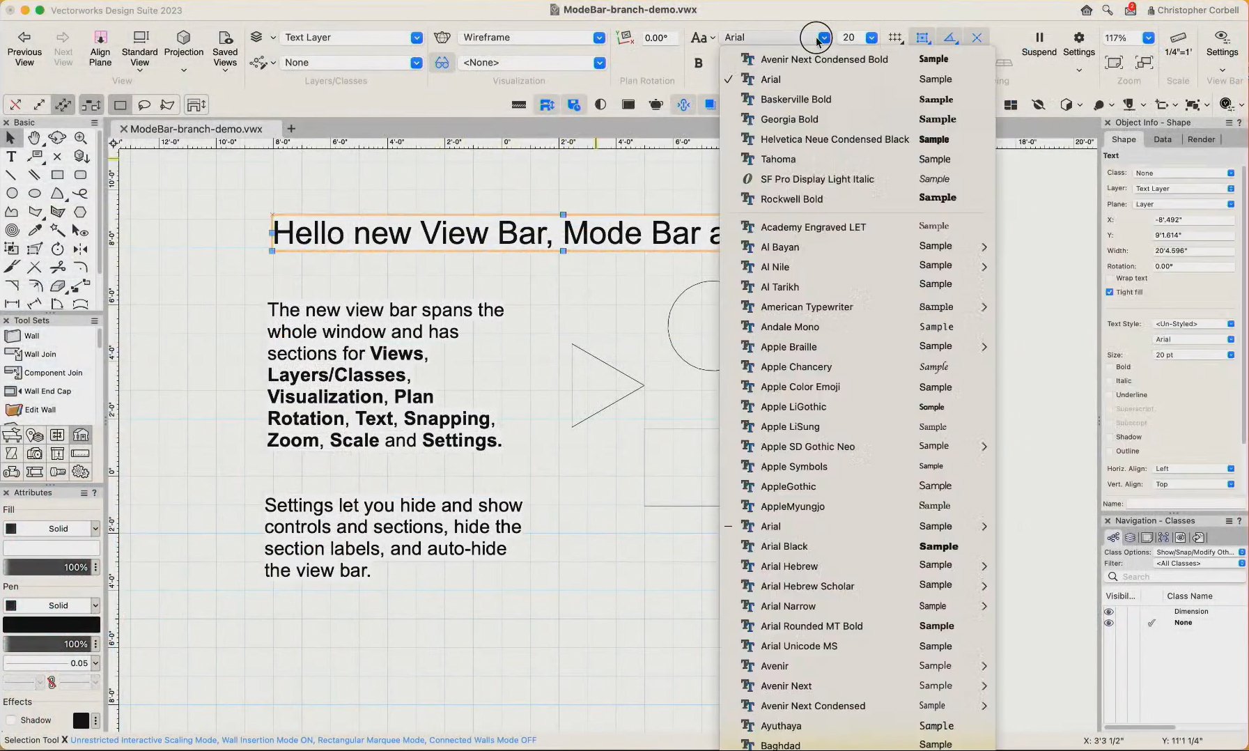
During the presentation he said that you could hide the titles, if I'm not mistaking. I think that it's a nice improvement. Only don't like the snap icons. Oneven row and the setting and suspend takes up a lot of space. Especially compared to the old place in the right bottom. Also the rotated plan icon with text has a lot of unused place below.
-
See for a demo of the new UI here:
-
How do I get the handle to the currently edited symbol?
MarcelP102 replied to MarcelP102's topic in Vectorscript
Somehow this worked, but didn't before🙃: Locus(0, 0); { drop a bread crumb } Waldo := LNewObj; Hp := GetParent(Waldo); DelObject(LNewObj); { remove bread crumb } IF GetType(Hp) = 16 THEN .... -
Hi, With Vectorscript is it possible to get the handle of the currently editing/opened symbol? I've tried al kind of ways and searched a lot but I'm unable to do this.. What am I missing? Any help please, thanks!
-
Downloads of vectorscript examples are offline
MarcelP102 replied to MarcelP102's topic in Vectorscript
@JuanP They are still offline. -
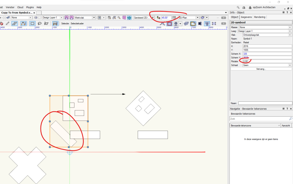
Hi @Julian_Carr thanks again for the script. I.ve used it almost daily now. There is only one small bug that happens in all three the scripts. When you are in rotated plan view and the rotation of the symbol is 0 the scripts places or cut/copy the object at the wrong place. Do you have any idea why this happens? Copy To From Symbol - rotation bug.vwx
-
Feature service seems to have an unwanted request limit of 2000 objects
MarcelP102 replied to MarcelP102's question in Troubleshooting
Request has been made: VE-103516 -
Feature service seems to have an unwanted request limit of 2000 objects
MarcelP102 replied to MarcelP102's question in Troubleshooting
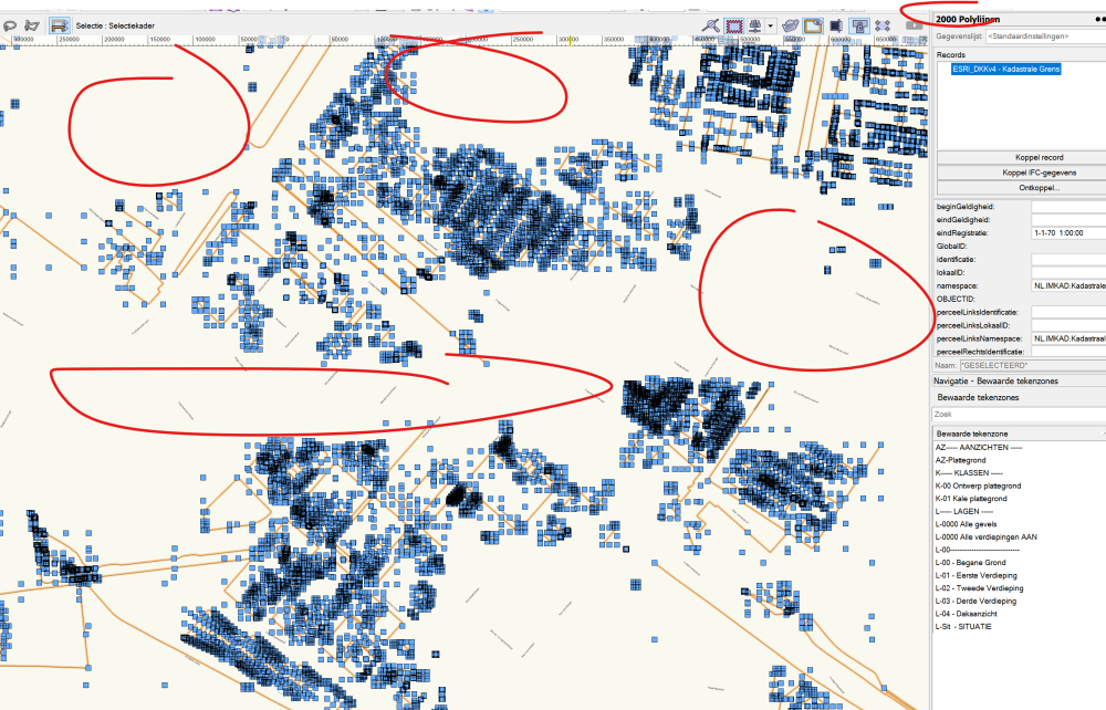
Hi @iborisov a warning is nice. But perhaps you could make use of the '&startIndex' parameter. See here: https://gis.stackexchange.com/questions/430493/how-to-get-all-records-if-wfs-output-limited-to-1000 From what I understand most GIS applications use this by default to get around the limitation. That's properly why it's not an issue for me to load the same source completely in Qgis. See attachment. Would be nice if VW recognize by itself that the limit has been reached and use the startIndex function to load the remaining data. Kadaster example.zip -
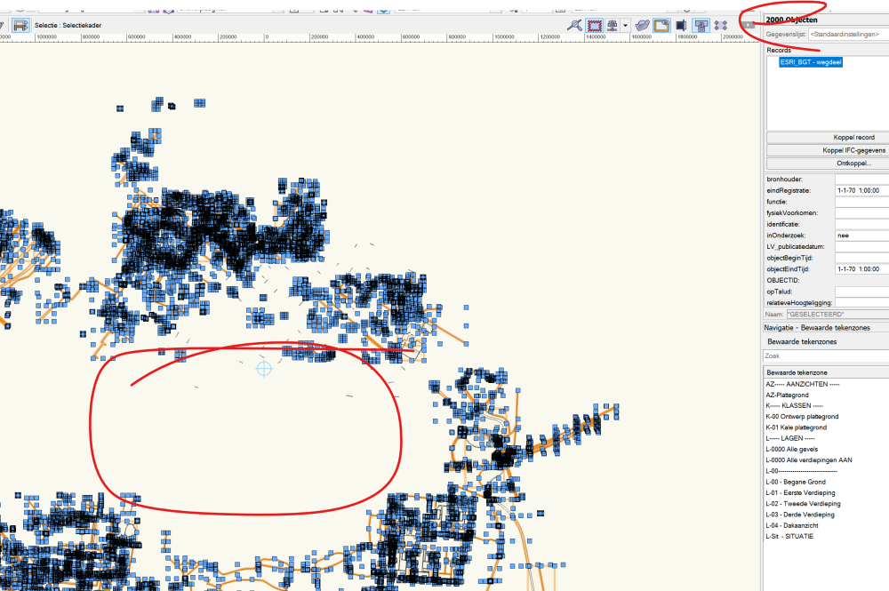
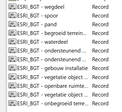
When using the feature service to get GIS geometry I noticed a request limit of 2000 objects. When I want to download the 'DKKv4 - Kadastrale Grens' feature service from ArcGIS online, that's the dutch parcel property lines, a lot of geometry isn't being downloaded. This feature service contains a lot of lines so when I zoom out by only a little bit the 2000 limit will be reached. Making this feature not workable. In Qgis using the 'PDOK services plugin' downloading from exactly the same source doesn't seem to be a problem. I've tried other sources like for example the 'BGT - wegdeel' feature service from ArcGIS online. When I zoom out a bit I'm also getting the 2000 objects limit. So it seems that it is not a problem of the source but a limit of Vectorworks? Ping @iborisov Do you know about this limit? Is there a workaround? I'm using VW2022 since version 2023 hasn't been released here.
-
Thanks @MullinRJ got it working. So cool to see the drawing being made in seconds by script instead of hours by hand🤩
-
Procedure DelRecordFormats; Var L1,L2, L3 :LongInt; S1 :String; Begin L1:=BuildResourceList(47,0,'',L2); For L3:=1 to L2 do Begin S1:=GetActualNameFromResourceList(L1,L3); If SubString(S1,'_',1)='ESRI' then DelObject(GetResourceFromList(L1, L3)); End; End; Run(DelRecordFormats); The script worked with a small modification, thanks again!
-
Fantastic, thanks! I will give it a try tomorrow.
-
Hi, After using the ArcGIS feature service to bring in georeferenced shapes I'm getting a lot of records making the file size grow. Also all new created objects will automatically get the records of the ArcGIS feature until I disable the georeference of that layer. That's why I want to make a script to delete the records. They are in the root of my resource browser. I think I need to use the DeleteResourceFromList command, is this correct? I don't really understand the example of the wiki. Any help would be appreciated.
-
Hi, So you can only use wildcards (*) for criteria fields? This works to select objects using 'voetpad' and 'voetgangersgebied' record SelectObj(INSYMBOL & INVIEWPORT & ('ESRI_BGT - wegdeel'.'functie'='*voet*')); But using ForEachObject and then the PROCEDURE using this code does not work? IF GetRField(h,'ESRI_BGT - wegdeel','functie') = '*voet*' THEN SetClass( h, '94 terreinafwerkingen-verharding-trottoir' ); Is this a limitation of Vectorscript? It would make scripts like this one below much cleaner, I simply use ='*rijbaan* { klasse verharding - rijbaan } IF(selType='inrit') OR(selType='rijbaan autosnelweg') OR(selType='rijbaan autoweg') OR(selType='rijbaan regionale weg') OR(selType='rijbaan lokale weg') OR(selType='rijbaan regionale weg: verkeersdrempel') OR(selType='rijbaan lokale weg: verkeersdrempel') OR(selType='rijbaan autosnelweg: verbindingsweg') OR(selType='rijbaan autoweg: verbindingsweg') OR(selType='rijbaan regionale weg: verbindingsweg') OR(selType='rijbaan autosnelweg: calamiteitendoorsteek') OR(selType='rijbaan autoweg: calamiteitendoorsteek') OR(selType='overweg') OR(selType='OV-baan') THEN SetClassN( h, '94 terreinafwerkingen-verharding-rijbaan', TRUE );
-
Screenplane to Layerplane without change 2D symbols to 3D symbols
MarcelP102 replied to MarcelP102's topic in Vectorscript
A check! I was afraid that when I convert a 2D symbol to group the screenplane objects of the 2D symbol would remain in screenplane. But in fact it changes to layerplane. I modified the script to not change the content of symbols. Thanks! -
When we use a script to move screenplane objects to layerplane all the 2D symbols turn into a 3D symbol. Because the objects are moved to the 3D part of the symbol.. Is there a script somewhere that changes screenplane to layerplane but keeps the symbol as a 2D symbol? I've used this script: PROCEDURE Objs2LayerPlane; { © Petri Sakkinen 2010 } {Modifed 2014, Ray Mullin, Pat Stanford to work with VW2015} Procedure DoIt (H : Handle); Begin SetObjectVariableBoolean(H, 1160, FALSE); End; Function ResetDef(H :Handle) :Boolean; Begin ResetObject(H); End; BEGIN FOREACHOBJECT(DoIt, INSYMBOL & ALL); ForEachObjectinList(ResetDef, 0, 0, FSymDef); Sysbeep; END; RUN(Objs2LayerPlane);
-
Easy one - drawing table auto positioning
MarcelP102 replied to pangolina's question in Wishlist - Feature and Content Requests
Yeah nice idea, make it independent of the annotation space. Like Revit does. Revit also have smart ways that auto align views next to each other. If they make the drawing label independent this can also function as a way to automatically align viewports -
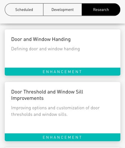
Look at the roadmap. Improvement are coming, at least some day😉. Fill in the form with your feedback so it will be received by the correct developer.