


J. Wallace
-
Posts
702 -
Joined
-
Last visited
Content Type
Profiles
Forums
Events
Articles
Marionette
Store
Posts posted by J. Wallace
-
-
@digitalcarbon it's always fascinating to see what you up to. Thanks for sharing.
-
6 hours ago, Benson Shaw said:
Hi, Joe
I think what you want is the Extract Loci from Point Cloud command. It's in v2019. Command is in the bottom of the Model menu in the Point Clouds heading.
It has parameters for number of loci to extract.
Here is a link to the Help topic on this:
Here is link to a short video demo for this and a couple other Point Cloud features in v2019.
https://www.youtube.com/watch?v=IZLxdtgVC8A
Your signature shows v2018. Look for them, but I don't think v2018 includes any of these features.
-B
Thanks for that @Benson Shaw I didn't realize that this feature was part of VW 2019.
-
 1
1
-
-
@Patricia Angelu you might want to check out the resources available on VW Youtube channel.
https://www.youtube.com/user/vectorworks/featured
-
On 1/3/2019 at 6:09 AM, rowbear97 said:
With VW 2019 you no longer need to use the default plant tags of old! Use data tags and even free yourself from the tyranny of circles or hexagons by making a custom data tag for plants and more.
@rowbear97 thanks for that...I didn't realize that this was a new feature of 2019. Looks very useful for Landmark applications, I may never use the traditional tags again.
-
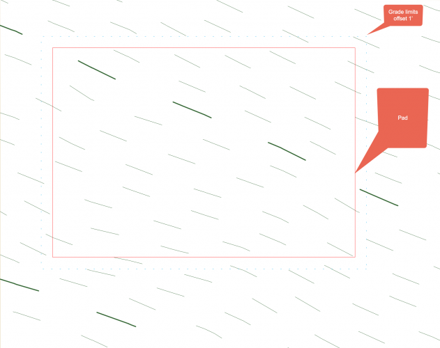
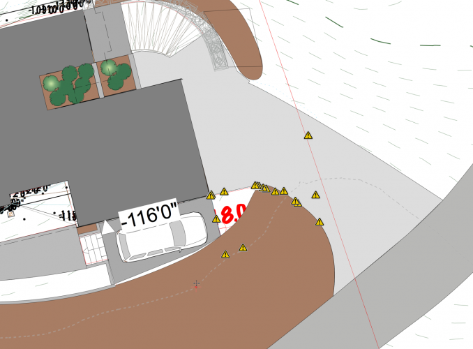
Brian do you any grade limits in place? These are an important part of adding a pad, in my experience.
I haven't had a great experience using pads with retaining edges but a grade limit should help your situation.
I often create a pad, then copy and paste this in place, change this to a grade limits within the OIP, then offset it by whaterever distance you wish. In this image, I offset it by 1'.
The model will then place your pad and use the grade limits for just that. There are lots of good videos out there on VW Youtube channel which you might want to check out.
A good practice can also be to put all your site modifiers into the same layer your site model exists. Hope that helps...
-
1
-
-
1 hour ago, line-weight said:
You are quite optimistic about its longevity.
Ha, quite right...2019 was what was in my mind.
-
We recently upgraded to a 10 core iMac Pro. I would say my workflow has increased by 10%.
Super happy with this unit, except to the cost, saying that we are looking at it through the long-term lense...hoping to get 5 good years.
We have another workstation which needs to be replaced and we're giving the Mac mini a serious look.
-
Super interesting @Rob Glisson we're in the market to replace an old Mac 'Cheese grater' some time in 2019. This looks like a great approach.
-
I live on Vancouver Island, BC Canada. A number of areas have free LIDAR information available but I found I needed someone to take this raw data and create contours. It's not expensive but this data is usually taken every 2-3 years so if there have been any site changes it won't be reflected in the data.
-
Hi @JohnAthayde great to see another permaculture designer in this group. I've used both LIDAR data and elevation data from a drone survey. I've got an associate locally who can take LIDAR data and create one-foot contours which is super helpful. I've only used this once as I prefer drone data where I can get contours and high definition images. The downside is tree cover, this is LIDAR's advantabe. Are you planning on making a site model from this?
-
22 hours ago, Peter Neufeld said:
Dear Jamie,
You might also consider exploring Sarah Barrett's Marionette network - presumably after you've got rid of the bits of the mesh you don't want included which is a hard thing to achieve I'd imagine. I haven't tried it but it should work like the Model>Point Clouds>Extract 3D loci from Point Clouds which is great.
Cheers,
Peter
Thanks very much @Peter Neufeld I'll check that out
-
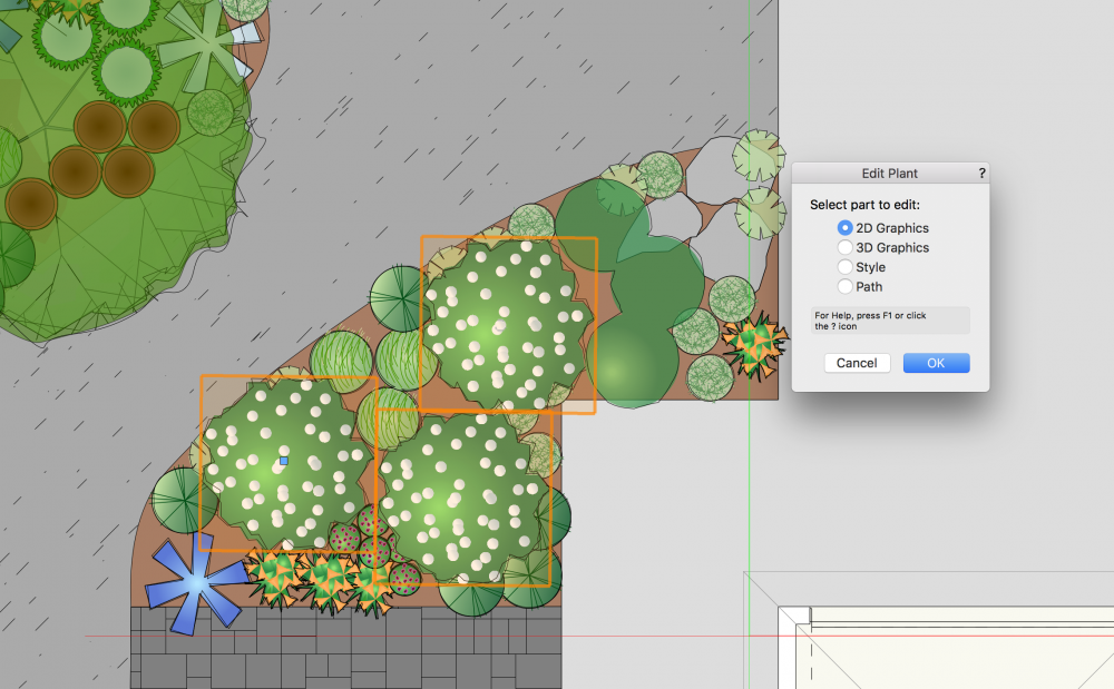
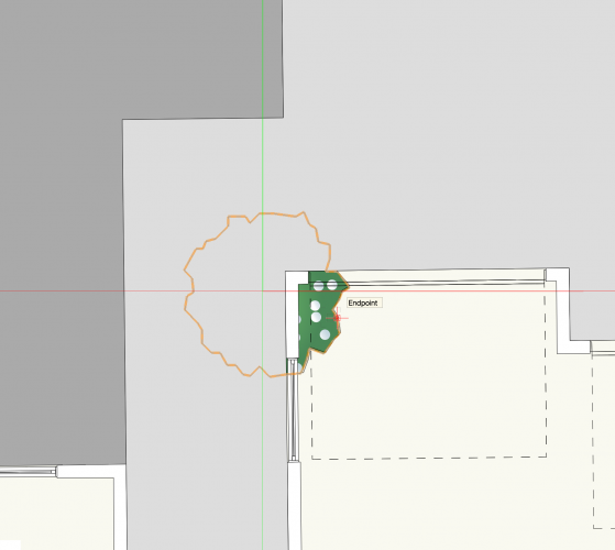
I've noticed that in VW 2019 Landmark when you go to edit a 2d plant symbol you get the plant symbol plus other aspects of the design rather than just the plant itself. It doesn't seem to matter what my settings are when I'm editing an object. Same results regardless of this setting. I've noticed this on several files but I'm just getting around to reporting it.
-
4 hours ago, RussU said:
Hi @J. Wallace I use this kind of data all the time.
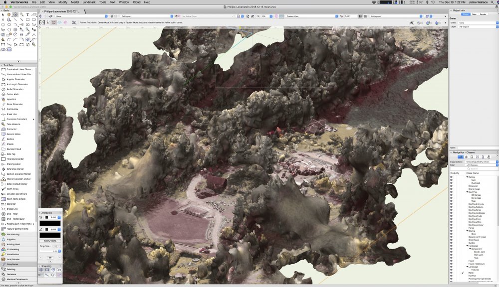
I rarely pull in the mesh though, as I don't find it all that useful. The mesh will have been generated from a point cloud in the first place, and that's what you want to use.
I make a new file and then import the point cloud in to 3 layers. One layer with 100% points imported, one with 50% and one with 20%. Called Hi, Med and Low Detail.
Then I use a DLVP to import it into my working file, so I can switch between levels of detail as required.
Point clouds are much more useful than the mesh, as you can snap stake objects on to the points as need be to create a native VW site model with as much resolution that you need. Too many stakes makes messy contours.
As for the mesh, it'll either have a huge texture mapped to it (with the weirdest mapping and UV's you can imagine) or it'll be coloured with vertex colours.
You should be able to get a point cloud with point colours anyway.
But which ever way you choose to go, I would definately recommend having the drone data in a seperate VWX and viewporting it in. Let me know how you get along.
While not all of this video is entirely relevant, some of this video may help (it was prepared for another client a while back)
7Thanks very much @RussU. That is super helpful information.
What your describing here looks like your taking cloud point data to make a site model, by snapping stake objects to portions of this.
In my case I get a set of shapefiles that contain 1' contours. I really like your approach and if I had a drone along with additional software, it's something that I could do myself.
Love the video you put together and thank you again for sharing this.
-
1
-
-
1 hour ago, Benson Shaw said:
Your middle image shows overlay of contours. Are those somehow generated from the mesh? Or applied from some other source? Are they extractable and therefore useful data for DTM?
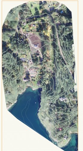
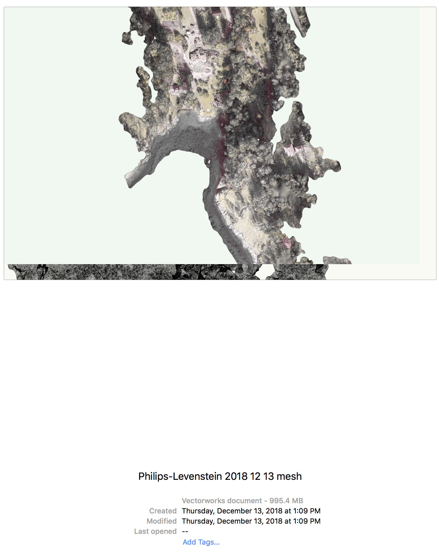
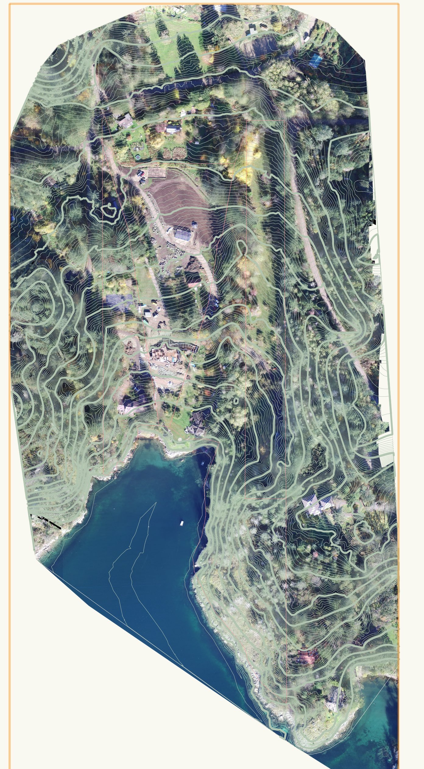
1Hi @Benson Shaw. The contours are from a site model which we created with shapefile contour data (from the drone, the shape file comes with other support files). Super easy to create, I think it took but a few moments. The high def image is from the drone, other than for observation purposes I haven't figured out how to use the mesh. It's a monster file that is best not mixed with the project data. I'm curious to hear how other folks use this type of information.
-
Thanks, @Dave Donley that certainly helped, the file is now 560mb on the lowest setting. I'm curious what other folks do with this type of data.
-
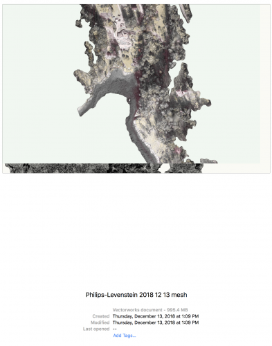
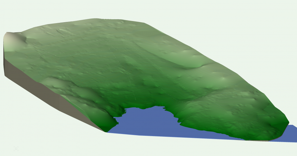
I'm starting a new project and have received some drone data which I've used for creating a site model as well as high definition images.
My question for people is whether (and how) one would make use of some mesh data. I've attached a screen shot and some information, the file is huge and an interesting reference but I'm not sure if it has any value besides that. You can see that once imported, the saved file size leaps up to 994 mb in size (this is the mesh only, no other data in the file, site model in a separate file). Love to hear peoples comments. Thanks
-
1
-
-
Just wondering if anyone has had experience applying a high definition drone image to a site model?
Not sure if this is doable...thanks for any thoughts you might have.
-
Great to see a new product that might help extend the life of one of 2012 Mac Pro workstations.
-
1
-
-
6 minutes ago, Rob Glisson said:
We are looking at replacing our iMacs with the new 2018 Mac mini's. We have one here run the office which is the new Mac mini with i7 6 core processor. Additionally, we have a eGPU attached to it. Our simple test is as follows:
2015 iMac 4 ghz took 19 minutes to perform a rendering
2018 Mini WITHOUT the eGPU took 10 minutes to perform the same rendering
2018 Mini WITH the eGPU to 4 minutes to perform the same rendering.
So far, it seems faster than our fastest 2015 iMac. We are considering switching our entire office this direction - 8 Mini's. Our thinking is that plenty of other companies make good quality monitors, less $$$ than Apple, and we can add a really nice Radeon RX Vega 56 Card with its box for $740 to each machine.
Advantages:
We can buy Nice 4K 27" monitors for $400
When its time to upgrade, keep monitors and eGPU.
Should we need to upgrade eGPU - can replace card in the box.
In future, can just upgrade MINI's as needed.
Initial Cost/station:
Mac mini, i7 6-core with 512 SSD, 32 gb RAM, and 10 GB ethernet port - $2,290 (with keybd & mouse)
Radeon RX Vega 56 Card in Sonnet Breakaway box - $740
2 - 4K 27" Monitors - $800 ($400 ea)
Total Cost for Station - $3,870 +/-
Thinking this will have a lower long term expense.
Does anyone else have thoughts on this?
Those are exciting results @Rob Glisson We have just two workstations and older 6 core Mac Pro and a new iMac Pro. Love the new unit as I can literally plow through work, I did not like the price(or the lack of upgradability). With another upgrade on the horizon, I like the direction your going and I would make a similar decision, and most likely will within the next year. In our situation having one computer more robust than another is very workable, I imagine this is not the case in most situations. Keep us posted.
-
I'm interested in hearing other speak to this. We just went through an upgrade to one of two workstations where we purchased an iMac Pro (very pleased with it so far). Our other machine will need to be replaced in the next year and the Mac mini is an interesting option.
-
On 11/20/2018 at 12:57 PM, Jim Wilson said:
I even have an iMac Pro here I'm going to test it with, not that it needs GPU improvement but just to see if I get the expected performance from the eGPU.1Thanks for all your hard work @Jim Wilson...I look forward to hearing about your iMac Pro tests. We recently purchased one and quite impressed by the performance.
-
1 hour ago, Tony Kostreski said:
Hi @J. Wallace,
I agree that site modeling could be improved upon to be more intuitive. If you haven't tried this already, create a simple 3D polygon or NURBS object and place it on the Site-DTM-Modifier class. It will be recognized as a site modifier object and gives you similar controls to the retaining wall site modifier.
Hope this helps! Please let me know if you have further questions.
-Tony
Thanks @Tony Kostreski. I have certainly used 3d polygons in the past to bridge these gaps. Question for you, I've never placed them in the modifier class and when I do I get errors that show up. It seems to defeat the purpose by putting them in this class? I'm sure there's something I'm missing.
-
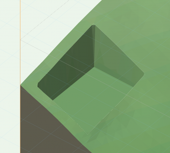
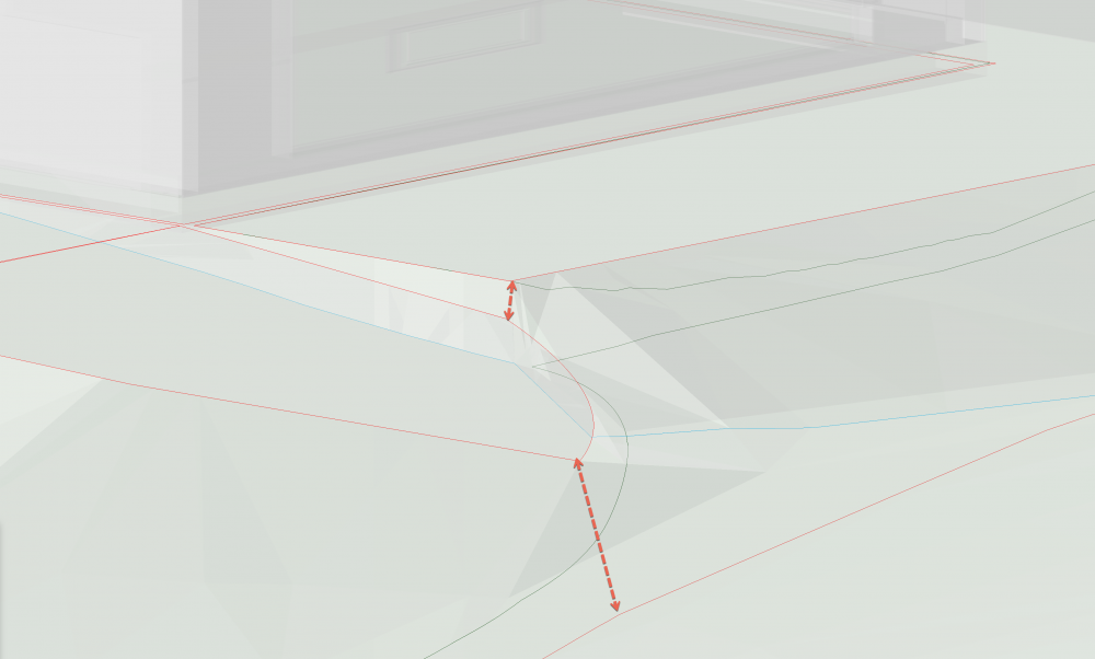
While working on a site model today it became clear to me that more intuitive controls over pad slopes and how they intersect with others would be helpful. In the image below the property is on a steep slope with a slope driveway approach. Blending all these pads together would be so much easier if we could adjust the corner or additional vertice elevation much you like do with the retaining wall site modifier where you simply click and pull up or down the vertice.
-
4
-
-
@chris I recently purchased an iMac pro to replace an older 2012 era Mac Pro. We have had this two weeks so it's early in the game for us. I'm hoping to get 4-6 years out of this and we'll see if that happens. Early tests on our 10 core machine vs our old 6 core unit saw a huge difference in render times. Mac Pro render 7:32, iMac pro 2:40. So far I'm really impressed but spent more than I was hoping for.
The one thing I don't like vs my old machine is the storage. My old Mac pro had 5 hard drives within it, the iMac pro has one, so my back up and data has to go into an external enclosure. Thunderbolt 3 enclosures are not cheap. Saying that the cost is actually spread out over the life of the machine. Good luck with your choice. PS check out refurbished units, we saved $1300


VW 2019 file has over 2000 folders appear in resource browser
in Troubleshooting
Posted
Just wondering what might have caused a current file that I'm working on to generate over 2000 folders within the resource browser?
It appears that all the folders are empty, I'm not certain when this occurred. It was a VW2018 file in it's earlier life. It has tons of existing tree symbols on it which might be related?
Thanks for any words of wisdom.