


Katarina Ollikainen
-
Posts
317 -
Joined
-
Last visited
Content Type
Profiles
Forums
Events
Articles
Marionette
Store
Posts posted by Katarina Ollikainen
-
-
As a contour has only one single z value: if there are a lot of vertices, go to top plan view, and convert the contour to a polygon (make a note of the correct elevation first). Then convert it back to a 3D poly and give it the correct elevation.
Modify > Convert > Convert to Polygons and then Modify > Convert > Convert to 3D Polys
-
 1
1
-
-
@jeff prince - The crux (as I see it) is that you must have the fields inside the tool for the data to land on when performing the Existing tree import, instead of adding the info manually - there's no geometry to attach the record to as the trees are created at the import. It's the chicken and egg scenario 😁.
Otherwise, the attached record is perfect.
-
1
-
-
@lisagravy, ok, let me see what I can do. I'll come back at the beginning of next week.
-
@lisagravy, at the moment, you have 10 extra fields - how many do you need? We might be able to help with something.
This is a thing feature will be extended, I just can't tell you exactly when.
-
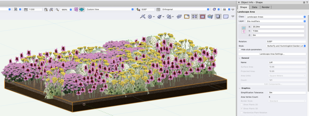
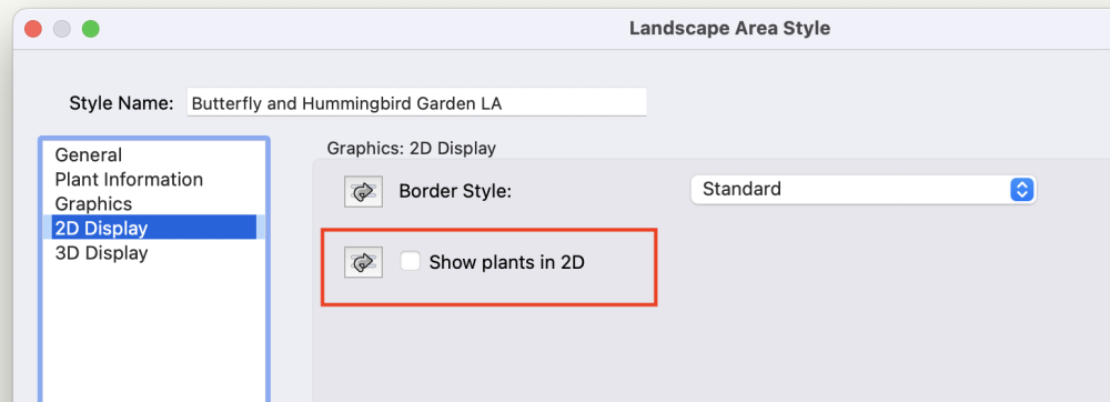
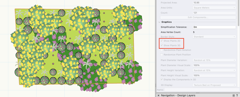
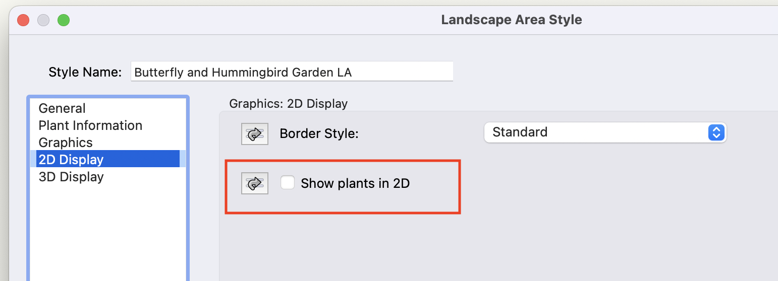
All the Landscape areas in the Vectorworks libraries are set to only show fill colour as default instead of each individual plant (in 2D). However, the 3D geometry is turned on as default - you just have to be in a 3D view to see it.
If you're looking for the individual plants to be visible in 2D, then you can go into the style and turn it on (see screenshot).
-
1
-
-
@Nico_be, we're working on a different approach to manage plant styles - it will be a more streamlined approach, and you won't need to run a script, so it will be better suited for most users.
I can't promise when this will be done, but we're actively working on it.
-
3
-
 1
1
-
-
Hi, this might be the wrong direction, but have you checked your origins? Often when you have strange geometry or things show up weirdly, it is because something in the file is too far away from the internal origin (the internal origin, not the 0,0 for x/y). This could be the issue if the texture is working correctly in another file.
-
1
-
-
@Tom W. Yes, the Hedgerow object is rounding numbers, as you can only place 'full' plants (the same behaviour as the Landscape area has).
Also note that the calculation works 'as a Landscape area' if you're using 'Area' and as a Hedgerow if you're specifying per 'linear unit' (which is the standard way to specify hedgerow).
Today there is no setting for staggered vs double rows - however, it's on the horizon and will be part of a future update of the Hedgerow tool. The same with the ability to edit the perimeter of the hedgerow without changing the quantities (if you're using plants pe linear unit).
-
- Popular Post
- Popular Post
Hi, this is included in 2023 and I've made a quick video on how to use it.
MassEditPlantStyle('');Hope it helps.
-
10
-
4
-
@TeeMuki, Hi, the site model had a huge update in 2023, and it works a bit differently now - loads of improvements.
If you post the file here, I'll take a look at it. However, you might also want to look at this video about the new site modifiers (if you have VSS) https://university.vectorworks.net/mod/overview/view.php?id=5243
-
1
-
-
Sorry, I have never come by that setup.
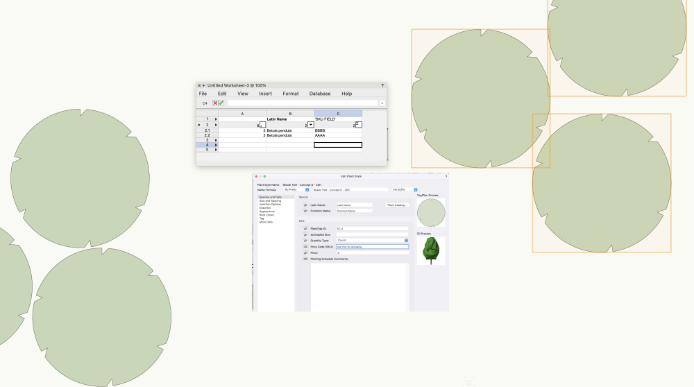
Perhaps it's better if you use a field in the plant style, for example Price SKU (one that you can have access to in the OIP, but that you don't use right now), set it 'per instance' and use this for grouping info. Then you sort your workshet by sum items on that - this will give you all single plants in one row and all grouped in one (or two or three, depending on how many grouping names you use). There wouldn't be anymore work than having to chose the correct data tag for the tagging - this way you can just go through the planting plan, find all groups and change the 'SKU' value for all of them at the same time. It seems a bit backwards to count plants via the data tag, but perhaps I'm missing something?
-
13 hours ago, DDD said:
Is there anyway to report the actual plant quantity instead of plant object quantity? My file is attached and thank you for the help.
Hi, if you report on plants (Plant Record) instead of the count of data tags, you'll get the correct quantity. I've added a very simple database report to your file, but you can use one of the preformatted ones - they're setup the same way.
-
@Michal Zarzecki, Adam at UK support has made a Marionette you can use for the existing UK tree requirements. I've asked him to post it here.
There will be some changes to the fields in the ET settings, but I can't say when they'll be implemented.
-
1
-
-
Hi @Michal Zarzecki, I think you've found a bug for the calculation of Landscape areas on flat surface - I'll file a Jira on it.
However, when you're using a site model, the calculation is automatically disabled, as the site model will take care of the increased surface area.
-
Just tested sending a PDF (exported from Vectorworks) from Outlook - it doesn't have an issue with changing opacity when opening. Do you have a sample?
-
1
-
-
Please do, and if you still have issues with it, let me know and we'll file a bug on it.
-
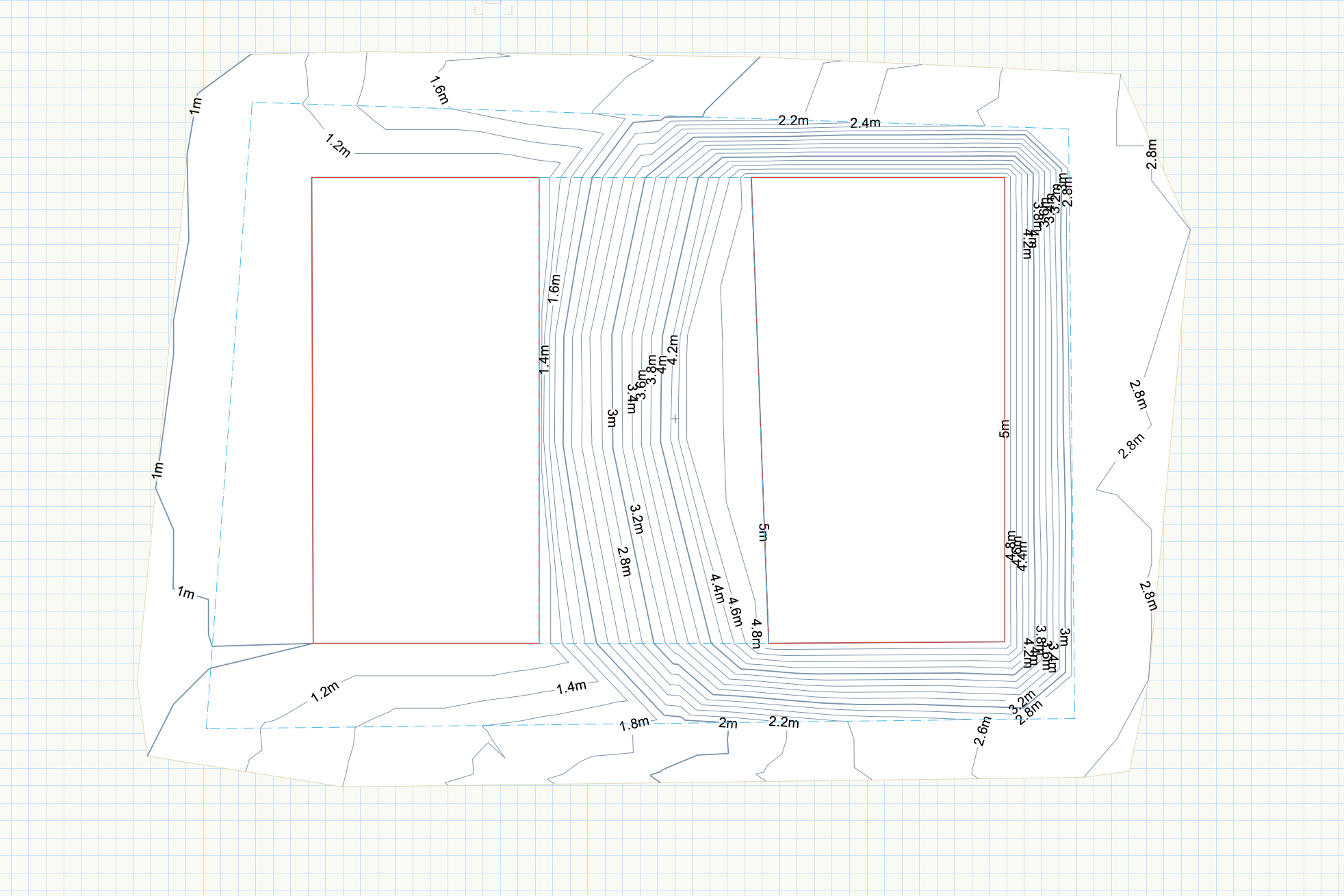
Yes, I've worked with it quite a lot and I haven't had any issues with it. It's good for situations between other modifiers where you want to be able to fine-tune contours. Below is a simple example where I have adjusted the contours between the two pads - instead of having them perpendicular to the pad edges, I've added a slight bow to get a more rounded, softer form.
Of course, there are many other ways to achieve this, but this is a good way for those awkward areas around other modifiers.
If you have a file crashing, can you either post it here or send it to me directly so we can see what's happening. It should definitely not do that.
-
2
-
-
@jeff prince, you're right - the main issue was that the original site model data was rotated in plan view. I copied the data and recreated the site model in the same file, and then it worked fine. I did the same thing with the array to test 😁
The landscape area was a case of just telling the site model to listen to the layer where the Landscape areas were and then connecting the Landscape area object to the site model layer.
-
1
-
-
@BCALJames, thank you for your input - we are working on the curb/border/edge and hope to come up with a solution that covers all kinds of edges, including 3D profiles. However, we're not looking at a solution only for the hardscape but a more overarching approach. I can't promise when this will be introduced, but it's a high priority.
We do appreciate everyone taking the time to share ideas and requirements - this is how we can make our tools even better.
-
1
-
-
Hi, @bob cleaver. Plants and landscape areas shouldn't be sent to the surface - they automatically adjust to the site model surface.
Plants don't have to be on a layer 'talking to' the site model - landscape areas do.
Are you saying the plants don't automatically adjust to the site model? If so, try to nudge them slightly while the site model is visible. If that doesn't work, please post a sample file, and I'll look at it.
I haven't seen a bug in SP5 that would have stopped this from working - I just tested it in a file, and it seems ok, but I might be missing something.
-
1
-
-
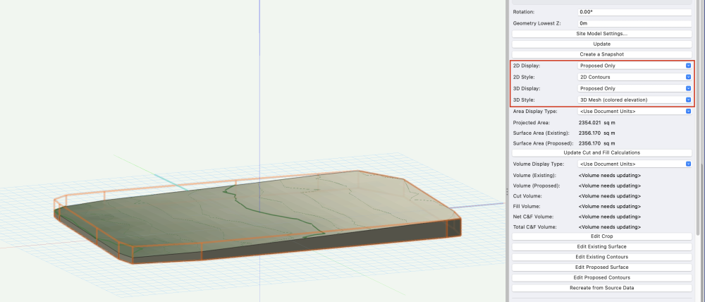
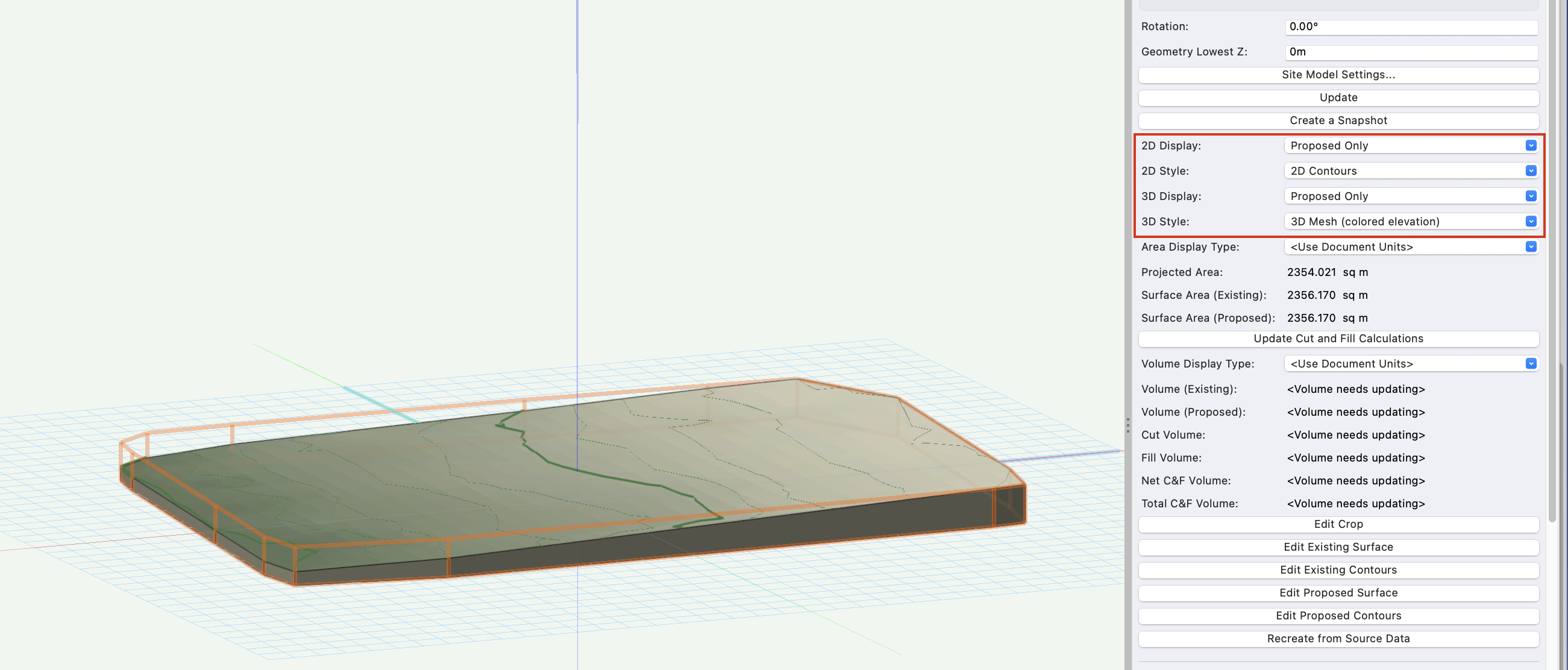
The existing and proposed site model is actually the same (from a user standpoint). You create the site model once, with existing site model data. You can then specify in the Object Info Palette if you want to look at the existing or the proposed site model. Make sure the proposed is selected, and then add a grade limit to the site and add the proposed elevations. Update the site model and you'll see the changes to the site.
You can always change back to the existing view if you need it, or you can create a snapshot of it for reference.
(you can also change the view in the Site model settings, but the OIP is quicker)
-
@JonKoch - is this a draped hardscape? If so, can you please post the file so I can look at it.
-
-
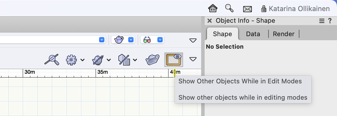
@JonKochJust a thought - do you see anything at all when you're in the edit mode? Do you have the 'Show other objects while in edit mode' turned on? If not, then you won't see either the aligned object you're editing or anything else. The view of the aligned modifier is only shown 'from outside' as you can't edit the boundary, only the surface modifiers


Import Tree Survey Tool - Extra Fields
in Site Design
Posted
Hi, my brain must have been on holiday already when responding to this post - the solution is so obvious.
As long as the 'Add to Record' is checked, the data will go into the record attached to the tree object.
You don't have to do anything fancy; it just works.
The only thing is that it's not visible in the Shape pane in the Object Info Palette but in the Data pane.