Michal Zarzecki
-
Posts
276 -
Joined
-
Last visited
Content Type
Profiles
Forums
Events
Articles
Marionette
Store
Everything posted by Michal Zarzecki
-
Hi guys, Have you ever experienced a problem where Properties are not updating/ responding to the object selected? I keep clicking around my model and Properties keep showing the same thing. I don't know one way to get them work. Sometimes they just 'get it' but sometimes they stay like that whatever I do. I have a feeling that VW sometimes gets into that 'mood' that it just refuses to cooperate. As if it was a temporary malfunction or bug. Often it disappears after restarting the program. Another similar problem is Object Centered Flyover (orbiting) mode. I have it selected, but VW doesn't execute it - i.e. sometimes it does, sometimes doesn't. Moody software :/. Exactly something that you need when under pressure. Any thoughts?
-

Huge Line weight when importing DWG's
Michal Zarzecki replied to VW-PAD-Bristol-2014's topic in General Discussion
Hi guys, can you advise how to control that behaviour when you use DWG as a reference rather then when you import the linework? I have project started originally in AC so have a whole load of our drawing as well as from other consultants so I am not going to import them to VW and save as new type of references. Many thanks for your thoughts. -
Hi all, Perhaps you have noticed something like the issue I am experiencing and would be able to help. I modelled a balustrade using the Railing Tool. I set the rail to be 50 mm. When I get to annotate the dimensions it says 49 mm. I can't think that this is any drawing inaccuracy as this was parametrised rather than drawn. I don't see any relevant setting in the Units pane to resolve this. I was about to post another query, but decided to append it here. When designing walls I encounter a misleading dimension information. In Properties it says one thing, whilst a direct measurement shows something different. But this is not a consistent behaviour. Some walls have in their Properties the height as per the measured distance from botttom to top. Any thoughts?
-
Railing Tool Post Position Input backwards
Michal Zarzecki replied to TomKen's topic in General Discussion
I am experiencing the same thing. @TomKen, have you managed to find out where this is controlled from? -
This is a very interesting too indeed. I tried to use it last week but due to the time pressure and a vague clue on how to use it I decided to give it ago another time. What I managed to check on my drawing was the alignment with the ortophotomap underlay. They seemed to be miles away. I understand that I need to align my UCS with the GCS. Again I understand that in VW, an imported dwg file retains its NE coordinates from the survey but is just centered on the drawing space. There are geodesic station points with [lat lon] coordinates on the topo survey drawing, therefore I should be able to use these for georeferencing, correct? Should that be done through the Document Georeferencing or one should change the internal origin first? Any step by step walktrough?
-
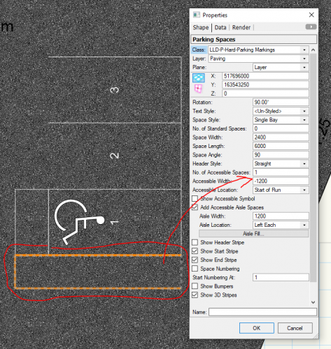
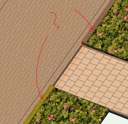
Hi All, Have you already tried Parking Spaces Tool in 2020? I used that tool just two months ago when I still had 2019 installed and it seems to have worked differently. What is new and odd is that when one creates an accessible space with the access zone, the width of the latter is added also to the parking space itself. Oh no no no! Ok, so I tried to go around and reduce the accessible space to 1200 (with the extra 1200 from the twin access zone it should be fine). Unfortunately, the symbol then appears not in the middle. For now I need only 1 accessible space so what I am doing is creating a new Parking Space object with only 1 parking space which is the accessible one. I define its width as -1200 [mm] and tick to have an access zone at 1200 as well. Then I need to do something similar to have the footer access zone. See below. Then I will add a hatch of the right size. If there is no other way, this is very disappointing. Again - a tool is to help, not to be a challenge. One can draw it more easily with no frustration. I would like to hear from others and if they bumped into a similar issue and how they got out of it. Any idea how to close the access zone (it seems to be open-ended)? What is wrong with the orientation of text? The Accessible Symbol seems ok whilst the text is at 180 degrees to it. Regards
-
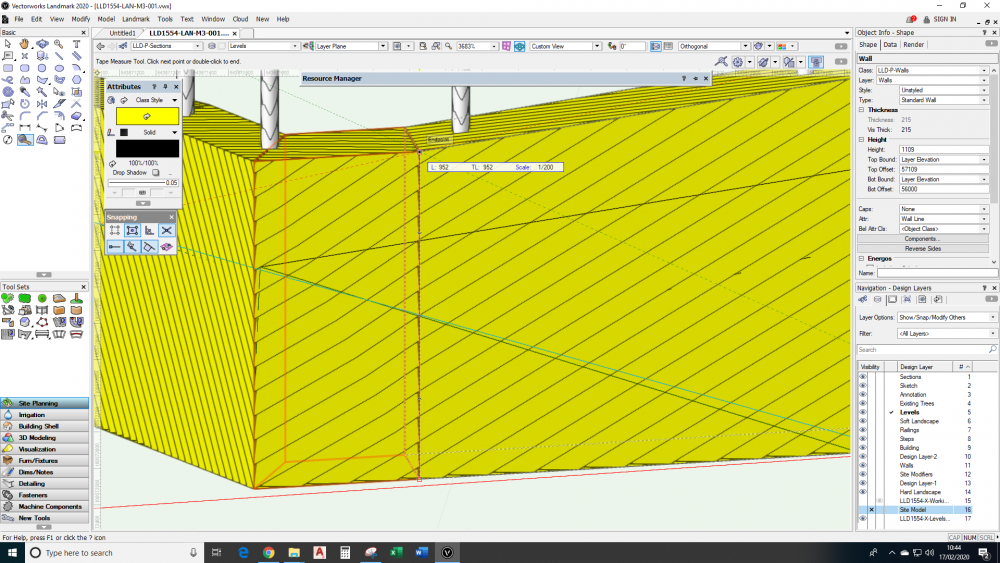
Hi all, I just opened my BIM model created in VW2019 to make some exports for the other team members and things went wild. And wrong for my workflow. All Hardscape objects just went mad. For example, the Edge hiding function doesn't work. Or works wrong, i.e. it doesn't hid/show the next edge but a random one. When I move to the next vertex and try to show/ hide nothing happens at all. Secondly, things were assigned to wrong classes - for example my road kerbs are grass now. What's even more interesting, within the same Hardscape some sections of my kerbs are showing one texture and somewhere else another. This is very unfortunate. What was meant to be a quick exercise, swamped me for some two hours, trying to understand what is happening and resolve the things, so at least a simple dwg can go to our partners. I have a feeling that this efficiency curve which was meant to be delivered with BIM is not the case now. Help please. Anyone else noticed similar behaviour in 2020/ after migrating?
-
@mike m oz, I though that on paper a few mm would be absolutely enough for the basic geometry. I still have a feeling that there is something I don't understand. I will study your file to see how things work. Many thanks for your time so far.
-
@mike m oz, Thank you for looking into this. There are a few things I don't understand though. How come the start point affects the linetype generation? The pattern is being repeated along a line anyway. You advised to change the settings to World. How come all default linetypes are set to Page, have similar size to mine and work just fine? Can that still be the starting point matter? When would I actually need to use the Page setting then? The way I understand how World vs Page setting is described in the Help Centre, is that with Page I will get the scale of my linetype the same, regardless of the drawing/ sheet scale. Correct? The bubble within the linetype is only a graphical feature and does not represent any true dimension, hence I thought that the World setting was not the one I should be interested in. Regarding the revcloud, I am not most fond of drawing planting areas as clouds, hence prefer a proper linetype. I don't mind the fill not getting into the 'shape' component.
-
@mike m oz, Have a look at this file. Perhaps you will note something I missed. Linetype test.vwx
-
2D Topographical Survey Levels to 3D and Site Model
Michal Zarzecki replied to Michal Zarzecki's topic in Site Design
@Pat Stanford, Thanks for your time. Have a look at the attached file. Attached is also the script which I found and was working in 2019. I hope these will tell you something. levels test.vwx 2D Loci to 3D Loci.txt -
@mike m oz, I think you misundertood. Maybe I was not clear. The line type does not work when applied to objects. It is not generated. The object is displayed without the stroke/ Pen. I recently migrated to 2020 and I seem to experience a number of unexpected things happening but let's stick to the linetypes here. There might be something I missed. I look forward to further thoughts.
-
Hi guys, I had my first attempt at creating a custom linetype which should reflect one that we use in AC. The process seemed very easy and straight forward, but the resulting line type is not being displayed at all. I created it in Page scale and followed the settings (like pen and fill) used in one of the pre-defined line types. Can't figure out what went wrong. Any ideas?
-
Hi All. Can you suggest a quick way to convert 2D topo from surveyor to Site model in 2020? There are only 2D spot levels (no Z-value) with no countours in the file. In 2019 we used to run a script recommended by someone clever on line, but it doesn't seem to work any longer in 2020 :/. Any thoughts?
-
Hi all, All the best in the New Year (two weeks in, but hey ho!). I wonder if anyone has already built some experience with the so much awaited Hardscape tool that allows for more realistic design of levels. We have just started a new project in 2020 and had a first attempt at it. And we struggle 🙁. Probably it's something we haven't caught just yet. For example, we don't understand the levels. A tiny example: We are creating a path along a building with the FFL at say 50.650. What we want to do is to define grades with the proposed levels or gradients and expect the Hardscape to reflect that. When we propose a Grade along the path to be at 1:60 from 50.650, the result appears 50.650 m above our surface - which means it is relative to the slab and not absolute. If we draw it from 0 at 1:60 then it works. Is there a way to change these to work with absolute values? The alignment settings are set to: Align with Objects on 'Same layer as Hardscape object'. However, the building slab and the Hardscape slab don't overlap/ touch each other, so I can't identify why my Hardscape is governed by the building slab. Where is the part I don't get? Any advice?
-
@Nikolay Zhelyazkov , this is what I needed - didn't see that option before. It's good, because it allows for the BS numbering, i.e. P01 etc. I think I am getting there with the TB settings. Can you refer to any webinar or tips on that topic? I would be interested to learn more about the custom formulas too. Regards.
-
To start from 00, not from 1 ;).
-
@Nikolay Zhelyazkov, thanks for that - apparently this is what it was. Quite confusing though. Regarding the spacing - I must have misunderstood your explanation. It seems to me that it isn't about the distance between revisions (like line spacing), but the size of the gap between the top of the lower and bottom of the next one. Well, I used 12% and it now looks right. Since we have been using Rev. 00 for the initial issue, I need to work out how to do that. Any tips?
-
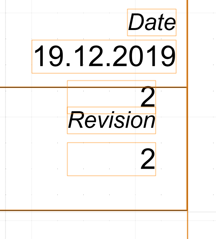
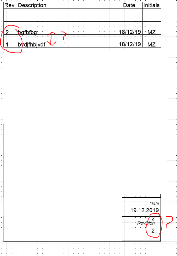
@Nikolay Zhelyazkov, thank you for the response. Indeed something is not working with that spacing, as the gap is too big, as shown on the attached shot. I tried to change it to 25% and there was no change - hence my lack of understanding. Regarding the second thing, I must have been misunderstood there. What I would like to achieve is to have the last, say, 6 no. revisions in the revision table, whilst the only recent one shown at the bottom right corner. At the moment, the latter is repeated as well. In the table, I use RevisionData.Number field, whilst in the bottom - IssueData.Current (or something along these lines). I thought that by doing that I would get what I envisaged, but not quite apparently. Any thoughts? When I have access to VW I will send you an exemplar file with my TB.
-
@Nikolay Zhelyazkov, could you explain a bit the concept behind that spacing factor - I completely don't get what that is, since I can't see anything changed when I use different values. Also, is there a way to show a number of last revisions in one place whilst showing only the last one when the Current Revision field is used? I have this issue as shown


-
What is going on with hatch scale/attributes? VW2019
Michal Zarzecki replied to Ride's question in Troubleshooting
Hi @Matt Panzer, I have, but no luck. Here is the shot of my hatch presets - perhaps I am missing something here. I would like to understand what controls the generation of objects like hatches, to make sure that what I see in the Design Layer is then what I get as an output from a Viewport. At this stage I don't have this understanding. Any hints or references to relevant posts, webinars etc.?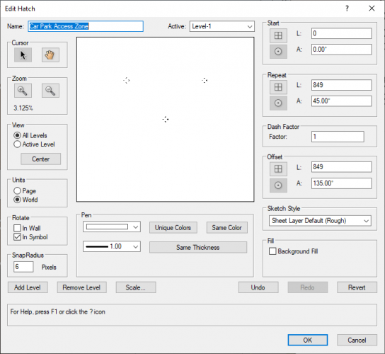
-
Parking spaces do not count properly
Michal Zarzecki replied to lgoodkind's question in Troubleshooting
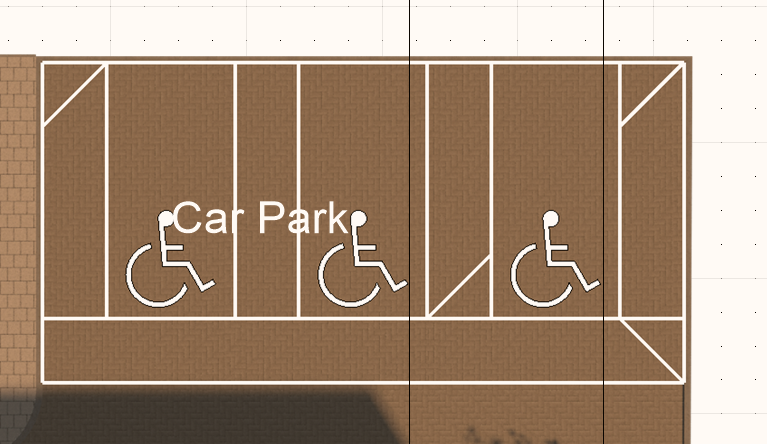
Thanks for reassurance, @Boh. Thanks for a hint about the 0-width space. I was hoping to delete it, but sometimes you may just want to cheat a bit ;). I actually used the same trick to make the Access Zone along the bottom/ entrance. Re the symbol - this is not a problem. To make it visible in 3D view would require further steps - I suppose I would need to make it hybrid. I am still not happy about the numbering though. I also found the inserting of the object quite perplexing. It seems not to matter whether one draws with the left or right mode - the spaces are always being created on the right hand side from the drawn line. This is contrary to what the icons suggest. Or perhaps this is a bug I experience 🤔. I wish it worked similar to the section mark or walls with regards to alignment. These are logical. This then results in a problem with numbering. I am never able to get this work so that the numbers run from left to right. And then I seem to have a problem with rendering of that cross-hatch. It is reproduced correctly on the Design Layer, but it gets too big on the Viewport. The scales are the same and the hatch is set to world units. I have no clue what is wrong, just yet.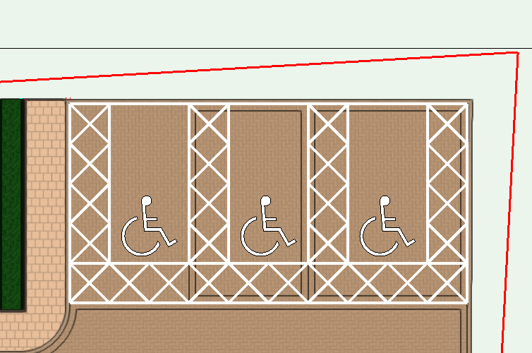
-
What is going on with hatch scale/attributes? VW2019
Michal Zarzecki replied to Ride's question in Troubleshooting
Hi guys, I think I have a similar problem with hatch scaling. My example is a hatch associated with a Car Park Access Aisle. I created one that reflects the legal requirements in the UK and set it to world. I would have expected that the hatch scale remains the same and it will look in the Viewport exactly the same as on the Design Layer. However, I see only one line of that hatch, most likely because it is so big (as per the world dimensions). What is the best way to proceed with this? -
Parking spaces do not count properly
Michal Zarzecki replied to lgoodkind's question in Troubleshooting
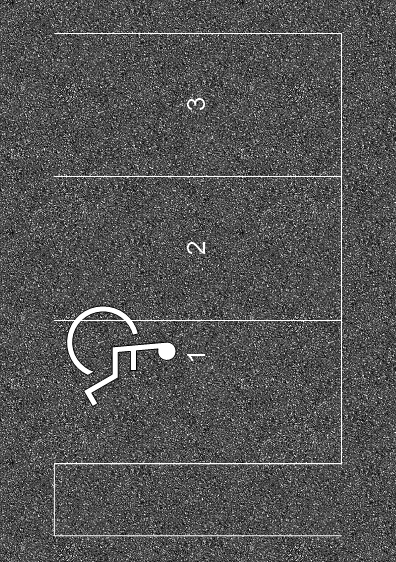
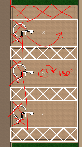
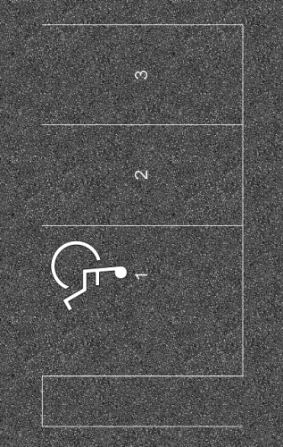
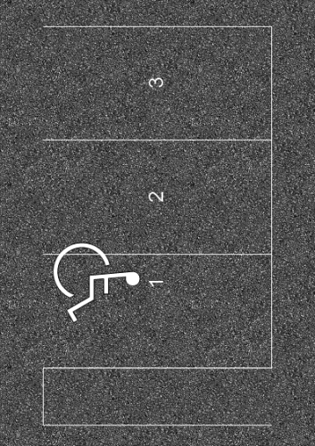
Hi guys, I can see you have really serious problems here whilst I struggle with the very basics 😬. Perhaps you will be able to help anyway. I am creating usual parking spaces, but I cannot figure out how the numbering works. The Accessible Symbol is aligned ok, but the numbers are displayed upside down. See below. I assume that the open end is the entrance side. Otherwise the AS would be upside down, I suppose. What can I possibly be doing wrong? Another thing is making the Access Zone/ Aisle at the end as well. I can't see such option. I tried to make one more space with the AZ and then perhaps delete the space itself, but there is no Edit behaviour. There is the need for the Access Zone to be at the entrance/ footer side as well, which I don't believe VW caters for 😕. Or I am missing something? Anyone experienced in car parks would be much appreciated. Regards.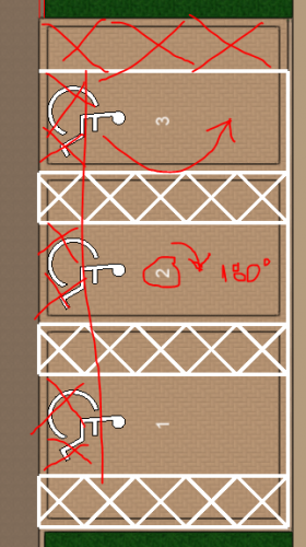
-
Hi guys, I have an elevation and Z value problem, which I can't figure out. I have my Design Layer set to 0, but when I draw, some objects have elevation set to 0 whilst others -3450. Is it possible that I might have changed my first Design Layer to 3450 and that now dictates the drawing level 0? If yes, how can I change that?