

Poot
-
Posts
137 -
Joined
-
Last visited
Content Type
Profiles
Forums
Events
Articles
Marionette
Store
Posts posted by Poot
-
-
On 9/28/2020 at 7:34 PM, Art V said:
Not just that, but adding subtitling would be nice too for those who have difficulty understanding the voice or following the speed of talking.
Although its not subtitles, you can adjust the playback speed in the options bar at the bottom of the player.
-
On 12/24/2020 at 2:18 AM, loretta.at.large said:
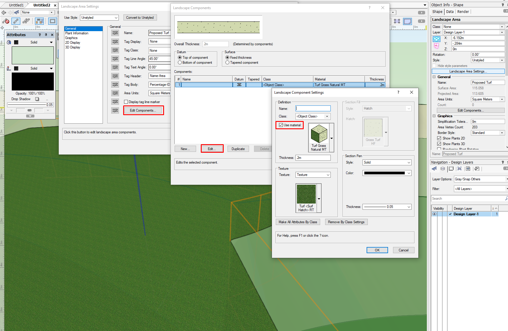
Somewhat unrelated, I've also been trying to understand the "Texture Bed" options in the "3D Display" section of the Landscape Area OIP. I selected it, but can't figure out how you tell it what texture you want applied.
@loretta.at.large Have you tried assigning a material to your landscape area? or perhaps checking the Render tab of the OIP?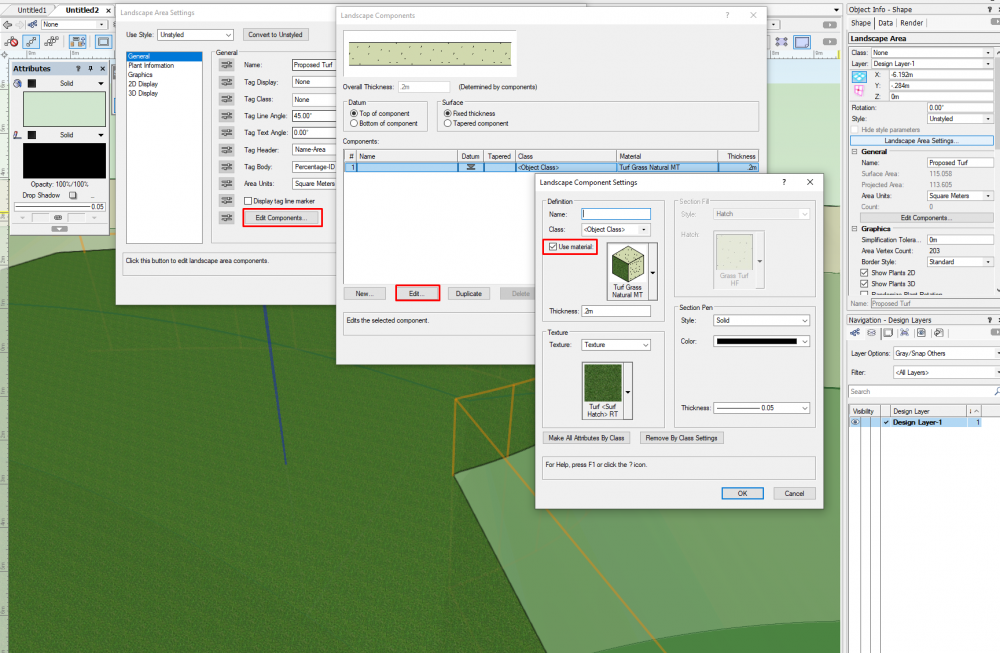
-
On 2/22/2021 at 5:24 PM, Tony Kostreski said:
Hi @Laura Stone, yes this is a known bug that'll be addressed in 2021 SP3 but for the time being, placing the landscape area on a site model will resolve the issue. Quickest way to create a site model is draw a 2d shape (like a rectangle), and then select "Create Site Model">"Site Model from Boundary".
Perfect! I was also wondering the same thing, and was trying to fool around with all of the component settings to no avail.
-
I use arcGIS mostly to produce all sorts of maps, but not in the normal workflow of my company. We usually receive our source data directly from the municipality for a variety of reasons. I have begun looking into how we might source shapefiles in addition to the general exports we recieve in various formats (see below) and if that becomes possible, then we would definitely start incorporating the simple GIS functionality in our workflow -- most likely in the planning/regulation and sketch phases.

-
 1
1
-
-
I would second the vectorworks university courses. You can select specific chapters in the more advanced courses and site design modules that will help a bit, and search for tutorials on generating reports and the like much easier than via youtube.
I'm also learning and it can be frustrating - but I think that getting over the hump for learning the planting tools (which I'm also doing right now), I'm looking forward to the capacity of the tools which are really the best out there in terms of whats geared towards landscape archtiects/designers.
Another bonus is that vectorworks staff actually respond to user requests at various levels, both for new features and problem solving. Coming from the AutoDesk world, where landscape architecture is an obscure profession, this is super nice.
-
15 hours ago, jeff prince said:
Personally, if the stair tool was to get some enhancement love, I want to see curvilinear stairs with variable flight width and proper tread depth constraints to fit the curve...
Fair points. I also think curved stairs would be a bigger priority than the step fall, and also the railing fixes. In the end its still faster to have the stair tool than not si I can't complain too much 🙂 -
Thanks for the input everyone!
11 hours ago, jeff prince said:There are many examples of features like this that would be interesting to have, but you have to ask yourself, does modeling such enhance the overall project when a simple detail will do the job? I imagine in the future, this level of detail will be common in BIM. However, unless it is interfacing with something else in a critical way, it seems like a lot of effort with little reward.
It is the default outdoor stair option, so its not about enhancing the project but rather doing what is necessary to meet code. The changes are slight but important given small tolerances for drainage fall on stairs in the first place.
I can't send drawings without this drainage slope applied, and it means adjusting the annotations made from any stair drawings. This basically means I cant use the stair tool if I need to send out detail drawings on them. Don't always have to, but often enough that it is a pain point.
Similarly, with the freestanding handrails, the only automatically generated options basically would never be built (a post on every stair??? or posts set at the edge of a slab/step???)
-Poot
-
1
-
-
Hi Everyone,
I'm just learning the ropes with VW, and have started using the stair tool which is great, but somewhat limited. I have two main issues some of you might have experience with:
-
For outdoor stairs in Norway, we usually draw them with a 1cm fall on each tread for drainage (important in cold countries where stairs ice up). Is there a way to incorporate this into the stair tool, or would I have to make a 2d section and extrude that? This means the rise would be 14+1(slope) for each step up, for example.
- With the stair tool railings options, I can't seem to place the posts with larger distances in the middle of their respective treads (the option for a post on every tread to the left does place them in the middle) Am I missing something, or is the solution to extrude tubes along a path to the right height and move those into place under the railing?
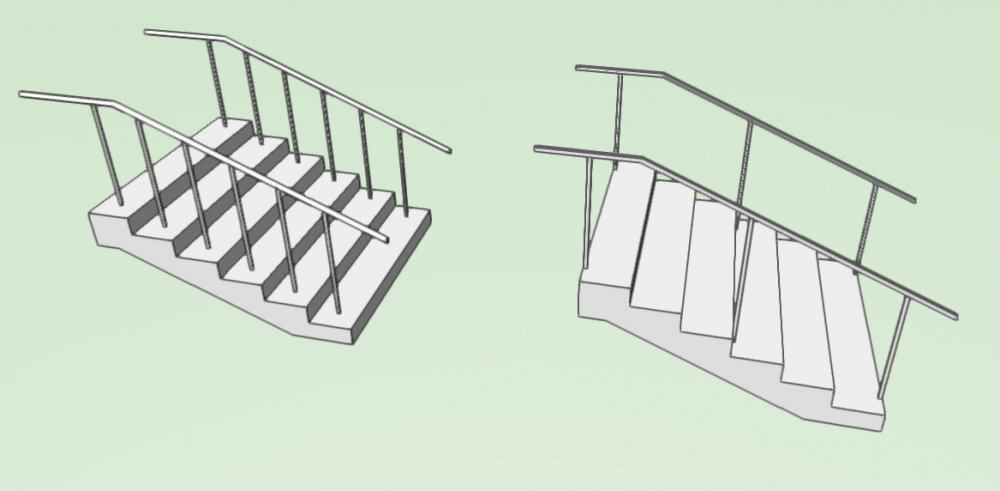
Thanks in advance for any tips!-
2
-
For outdoor stairs in Norway, we usually draw them with a 1cm fall on each tread for drainage (important in cold countries where stairs ice up). Is there a way to incorporate this into the stair tool, or would I have to make a 2d section and extrude that? This means the rise would be 14+1(slope) for each step up, for example.
-
Importing the IFC file as a reference worked, and seems like a good solution unless you'd need to pick or use any of the IFC elements (not really needed in my workflow).
I will fool around with importing the IFC into a blank VW file and importing that (not as a reference) to see if that also works in the case more control over specific elements is needed.
Thanks for the tip!
-
On 3/5/2020 at 5:35 PM, bgoff said:
@Cara2 What I like to do in this case is double click the DTM, Edit existing site model contours (created from the modifiers on the existing terrain), in this window select all contour lines and paste them in a new document or even the same on another layer. Then select those pasted lines and convert to 3D Poly, then ungroup the mass. You then have new lines to create your site model based on the altered original DTM.
Hope this helps!
I have tried this, but since I used an elevated slab modifier (to creat a cutout for an existing building in the DTM) the contours placed vertically on top of each other cause problems when remaking a new site model from copied contours.
-
1
-
-
Hello everyone,
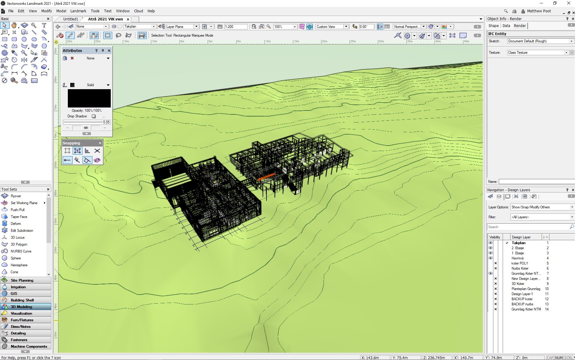
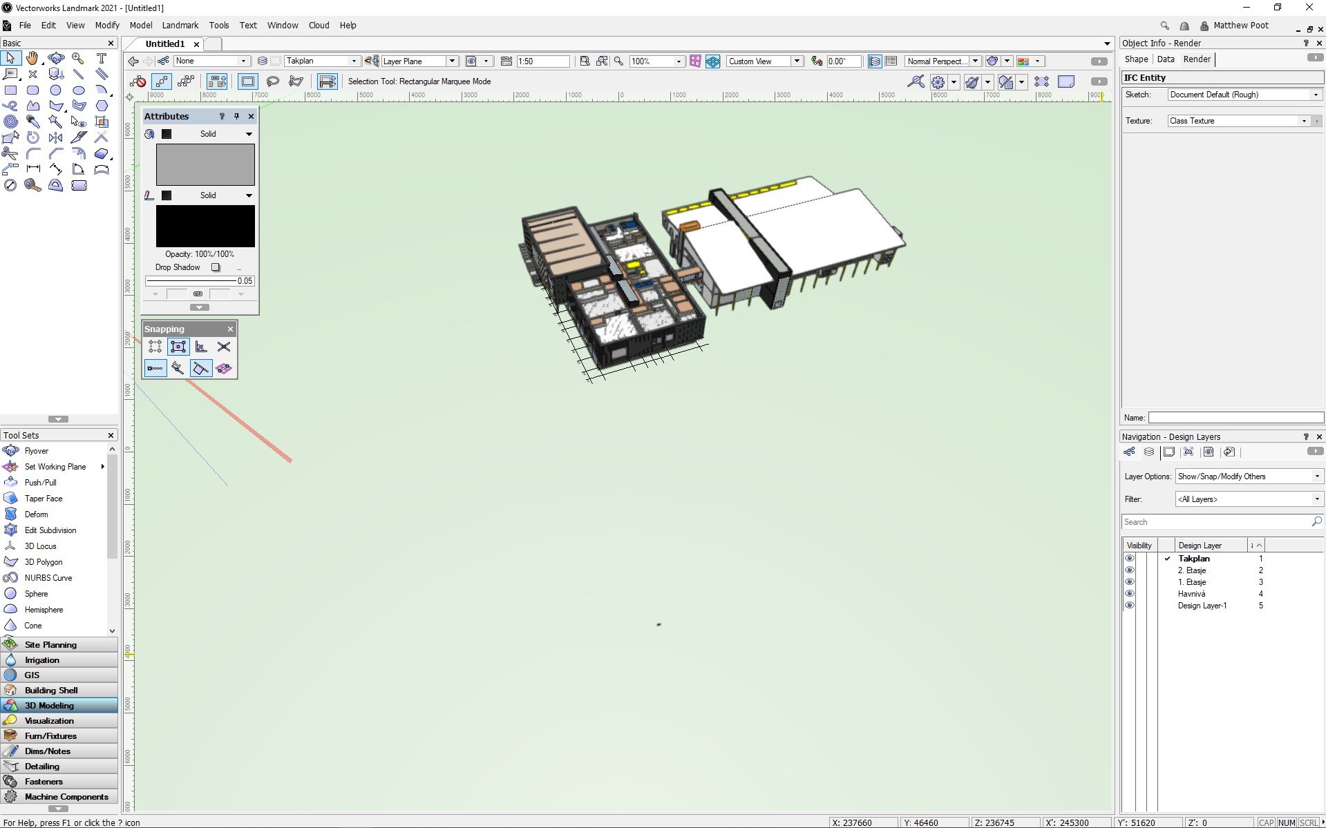
I'm running Landmark 2021, and have a problem where importing an IFC model of 2 buildings into my drawing with a 3d site model.
Problem: When viewing in 3D, the IFC model is only showing in wireframe, regardless of the display settings for OpenGL.I currently have the default OpenGL rough sketch settings, and the same IFC works fine imported within a blank document. I have both the internal & local origin points within 200m (~650ft), and have tried restarting and basic problem solving steps, as well as changing some of the OpenGL options.
The images show the same IFC in an empty, vs the working file using the same settings.
Any help or tips would be greatly appreciated!


VW2021 Landscape Area 3D Components
in Troubleshooting
Posted
It seems to be a bug that will be fixed in the next service pack: