nca777
-
Posts
120 -
Joined
-
Last visited
Content Type
Profiles
Forums
Events
Articles
Marionette
Store
Everything posted by nca777
-
Open Beta Program
nca777 replied to Kevin McAllister's question in Wishlist - Feature and Content Requests
This. We recently invested in VW Landmark as a small landscape architecture office. The LA field is vastly underserved in the BIM department and Landmark may be the only tool that even begins to address the needs of a modern-day LA practice. However, the program is admittedly still geared, in my opinion, for garden designers rather than landscape architects. We need more robust and accurate grading and roadway design tools specifically. I would like to have some assurance that NNA is working towards the tools I need in a timely manner. I would even be more than willing to help provide input and testing as necessary to ensure the tools are developed properly. I think there is a passionate community here along with a coming wave of LA's more than willing to contribute to the development of a great Site Information Modeling toolset! -
Import IFC from architect workflow please.
nca777 replied to nca777's question in Wishlist - Feature and Content Requests
I think we're mostly on the same page. The trouble I am having relates more to the fact that we work in a very mountainous area with steeply sloping sites and very stringent development code. The architect is sending us models of the site and building but often times modeled at zero elevation, sometimes rotated arbitraily. I want to use the surveyors very good georeferenced topo data to elevate the IFC (architects building) to the correct elevation(s) and orientation. I can do this with current tools but not confident in the degree of accuracy. I am already using DLVP's to reference IFC and other external data, so not necessarily manipulating original geometry. Make sense? I've got to think there is a standard-ish workflow out there. Also how do you set the finished floor elevation of a building? I cant seem to find a tool that snaps to/reads the building geometry elevations?? -
Will-- I would love to see your technique in action. Are you in Maine? Please check your messages. I sent you a note... N
-
Using Landmark for about two months now and running up against what seem to be software limitations. Are there tools in Landmark for creating complex roads/paths with custom profiles, ie various curb and crown profiles? This is a HUGE must for modern day landscape architects. More specifically, we need to be able to create roads with stations such as in the polyline road tool, but with the editability of the nurbs road tool. We also need vertical curve/alignment controls. The problems with current tools: -non-realistic relationship to site model/grading and lack of vertical curve controls -lack of profile controls, ie crown and curb/gutter profiles -lack of customizability and accuracy. We need to be able to create a road with various stations at varied elevations with various curband gutter profiles and customize turning radii at junctions.
- 3 replies
-
- 2
-

-
- site modeling
- grading
- (and 1 more)
-
Import IFC from architect workflow please.
nca777 posted a question in Wishlist - Feature and Content Requests
After about two months with landmark I feel I am beginning to run up against the softwares limitations--limitations I strongly feel define the product as a professional landscape architects tool versus one more geared for garden design. We always import IFC files from architects typically working in archicad or revit. I would like to see or hear some detailed workflows on importing IFC models, setting accurate finished floor elevations and doing initial site modeling (including foundations). Most of the architects we work with do an initial pass at grading/site modeling.I need to re-model their site grading somehow so that I can easily edit in VW. A good workflow video (using a sloping site, because sites are never flat) would be great. Any resources out there? -
agreed on the 'hideous plants' comment. vw needs some input from landscape architects and designers. I'd take it a step further and say forget about the color plan rendering priority. Most designers want good linework, black and white plans.
-
-
LANDSCAPE ARCHITECT HERE WORKING WITH ARCHS IN ARCHICAD. WE HAVE BEEN EXCHANGING IFC. JUST GETTING THE HANG OF IT AFTER YEARS OF CAD...
-
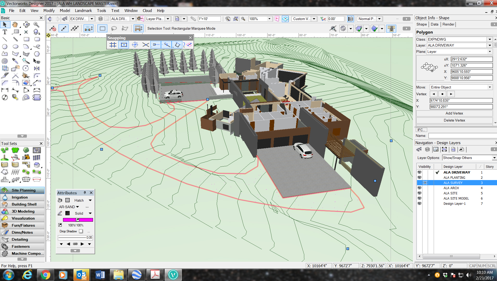
We just signed up for Service Select, but not finding much useful information on creating roadways. We are working on a large site with a long existing gravel driveway. It is an irregular shape and follows the sloping site. I need to show the existing roadway on the terrain model, with existing grades and make edits to areas we are affecting. How do I simply create an existing poly and have it follow the existing site model terrain? How do I make a new road poly that shows new grading only in the areas we are affecting? Screenshot attached....

-
Snapping to geometry in referenced layers in rotated plan view not working VW2017
nca777 replied to JJe's question in Troubleshooting
Finally, after fiddling with a non-snappable dlvp for a couple day I have determined that this is the issue I am experiencing. Have any of the service pack updates addressed this issue? -
Will do, I am using a crop object. We run pretty high end machines with 4gb cards, but could be. I'll continue to troubleshoot and post back. thank you.
-
Cant upload because the file is 125 mb. A lot of really weird stuff going on though--if I start a new blank file and reference in the same file(s), snapping works. However, re-referencing the file into the original document fixes snapping (seemingly), but when I rotate to isometric view the referenced model disappears and the dtm changes color...bizarre. Is there some kind of origin issue perhaps? Kind of lost here now, thought I had it all figured out.
-
Not able to snap to referenced items in viewports
nca777 replied to mat8iou's topic in General Discussion
Any resolution to this? I'm experiencing this issue now. It seems rotated top plan loses snap capability in dlvp's. -
I am referring to DLVP (Design Layer ViewPorts), not Sheet Layers. I am referencing an architects IFC building (via VW shuttle file) into a master site plan drawing. I have rotated, moved, and elevated the DLVP (building) to the correct location elevations based on the cad survey. All good to this point. The problem comes when I need to SNAP to the objects being referenced via the viewport. It seems I am completely unable to snap to the viewport objects no matter the settings I try.
-
Is there no way to snap to viewport objects? Theres gotta be...what am I missing?
-
Thanks Benson. I have been experimenting with the contour mode tool. This does seem to get close to what I have requested. The output is still fairly difficult to control precisely. It seems one would need to use the contour tool in close coordination with the grade limits tool to refine and re-adjust grades. It occurs to me that simply adding vertices to the proposed contours would make this refinement process much more intuitive and accurate. Getting closer....thanks!
-
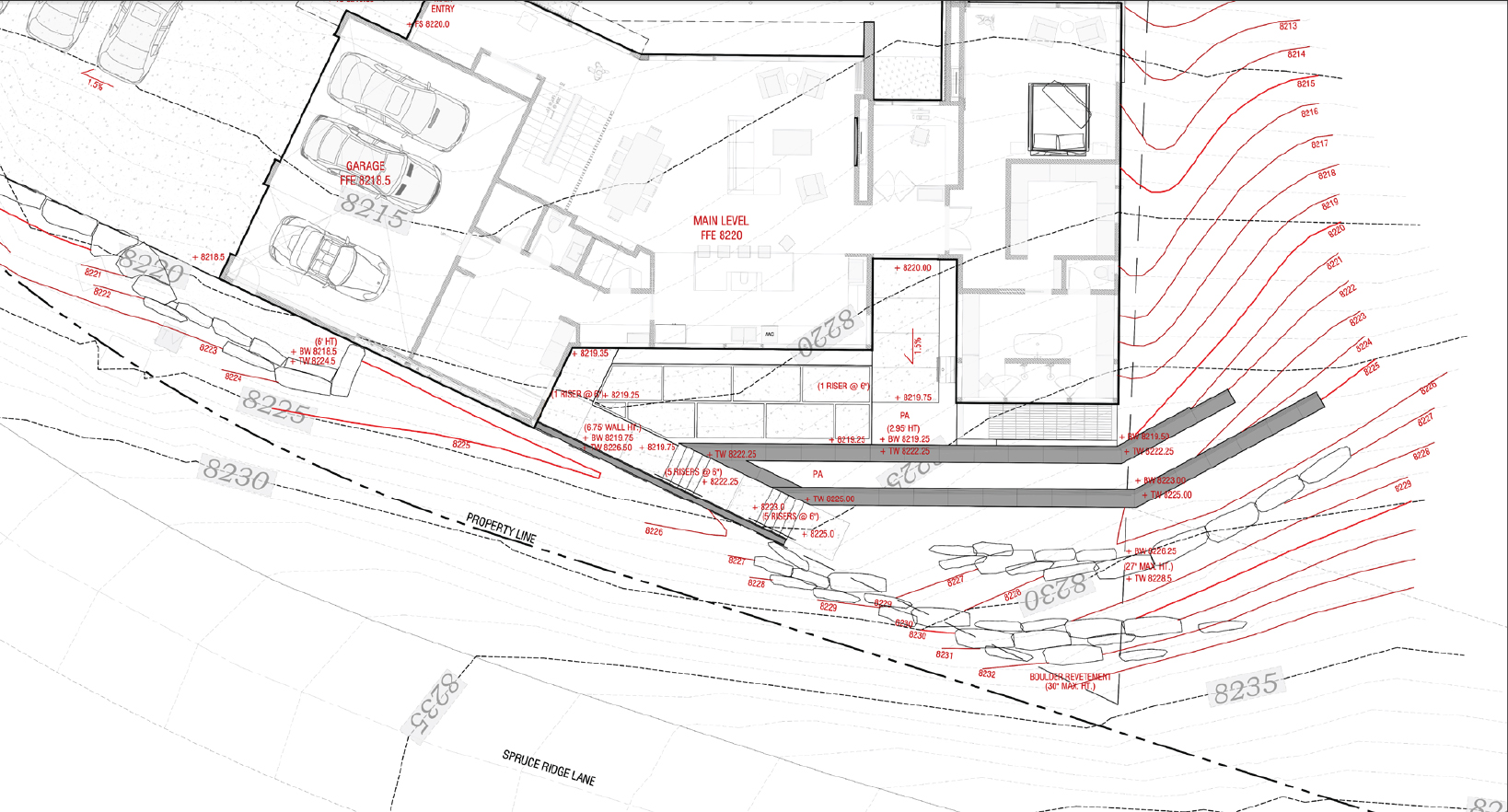
Jim W -- To clarify--I want to be able to manipulate only PROPOSED contours in a similar manner to the procedue you suggest for editing EXISTING topo. In my experience there is little need for editing the source/existing, but this is exactly what I would like to be able to do with the proposed. I would also like fine controls over grade extents or rather 'tie-in' locations with existing contours. Lastly, it would be great if there were a symbol for tie-in locations like a dot. Heres a CAD screenshot of a grading plan for a residence where we need to carefully control and limit where our proposed grading ties into existing as well as careful consideration for slopes. Again, what you suggest (edit source data) would be perfect if applicable to proposed topo. Please let me know if I'm missing something.. Thanks!
-
I cannot emphasize enough how imperative it is for landscape architects working on virtually any projects scale to have the ability to directly manipulate/reshape contours. Not having this feature is almost a non-starter for our firm in VW. I hope that this is a TOP priority for VW developers!
-
Anyone? Having the ability to sculpt topography is a fundamental of landscape architecture--I've got to believe someone out there has raised the issue before ?
-
We are again evaluating capabilities of VW Landmark in our landscape architecture practice. We've worked through several real-world projects and overall pleased with the tools and performance. One area we see opportunity for vast improvement is in grading/contour controls. Have any improvements/tools been added or in the pipeline for allowing more fine control of proposed contours? It would be GREAT if somehow it could be possible to simply enable vertices on proposed contours that the user can drag and adjust like a polyline, while updating the DTM. Seems very simple and would eliminate the need for what I would consider overly complicated 'modifiers.' Anything I'm missing? Is there a way to refine contours?