lrucker
-
Posts
9 -
Joined
-
Last visited
-
NE of stake points don't match NE in report
lrucker replied to lrucker's question in Troubleshooting
I actually tried using the X and Y in the report and it also did not report correctly. I have a meeting with Bryan this morning so maybe I'll be able to resolve it then. Thanks for trying to help. -
NE of stake points don't match NE in report
lrucker replied to lrucker's question in Troubleshooting
Feet/Inches - And they are displayed in Vectorworks as Feet/inches, but maybe the report is in another unit? -
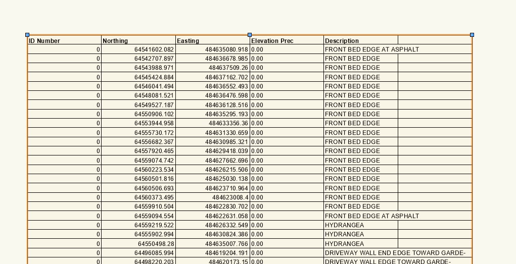
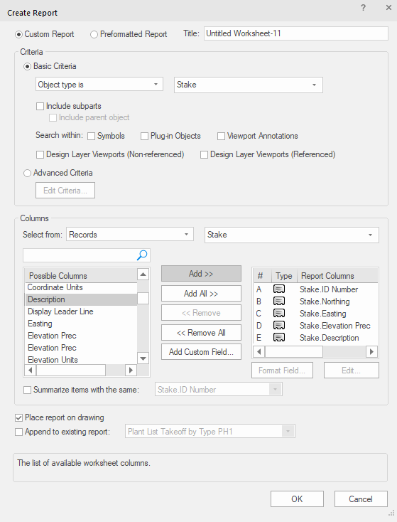
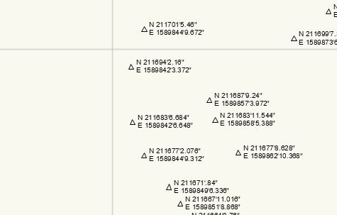
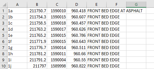
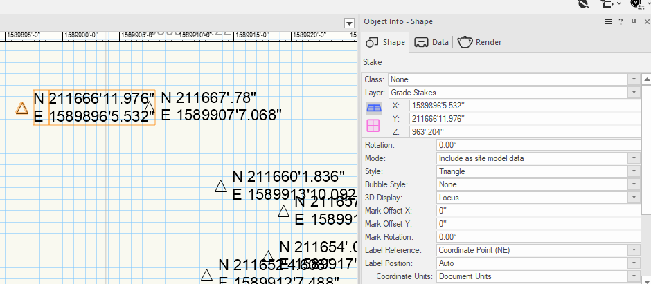
Hi all, I need to create a report of the northing and easting of stake points I have placed in a design so that I can export them via an excel spreadsheet/csv document to a Trimble. When I create the report, the northing and easting points are majorly off from the northing and easting data as it appears next to the stake. I have set the user origin in the document to a property in KY and imported stake points from the Trimble when we surveyed the site. The stake points come in correctly over the property on the VW aerial. When I create the report, the new stakes, as well as the original survey stakes are showing off. Also, the X/Y coordinates and the stake coordinates match each other in VW and match the original csv file that I imported, but don't match the report. I am sure I have a document setting wrong, but I have no idea what it is. I am really afraid of exporting the coordinate data to the Trimble and finding out that it is on some other property . . . The following screenshots show the report that I created, the data as it appears in the document, and the data from the original csv. I appreciate any help you can give me! ***You may remember that I posted a while back that I was working with a template that had a problem with its internal georeferencing. This data is coming from a clean template that has the default georeferencing from VW for the US, which is the Washington Monument in Washington, DC. I have watched Tamsin's video on GIS which was very helpful!


-
Setting a Georeferenced Template Back to 0/0
lrucker replied to lrucker's question in Troubleshooting
Thanks Tamsin! I'll try that and I still need to watch your webinar. I'm trying to do so many things at once here. Thank you so much for your help. -
Setting a Georeferenced Template Back to 0/0
lrucker replied to lrucker's question in Troubleshooting
I really appreciate everyone ringing in on this. I'm sorry I've been a little MIA because work is intense right now. I do need my template to have the georeference to be at 0/0 because we pull in DWGs and georeferenced elevation points from a Trimble. It would be so handy to be able to have it all pull to the same location. The new development is that our VW trainer gave us a script to open within the template which is supposed to clear the imbedded georeference. Unfortunately, even after moving the script into the template file and running it, nothing seems to have changed. There's no busy indication to even show that the script is running so I don't know what is wrong. Our trainer is very good and popular, so I haven't been able to get time with him to figure out why the script won't work. Meanwhile, I am working on new files with this template and having to chase down the Trimble points out in space and manually line things up. Maybe this should be another thread, but does anyone know of a good private VW trainer who I might be able to pay to help me streamline my workflow? While I have been working with VW since 2011 (I think.), I never had to work with georeferenced data or make 3D site models professionally. I also had to take a hiatus when working for folks who didn't use it. Now that I am using it again, I have gotten the Core Certification, Landmark Certification, and I am working through any training videos I can find within and outside VW. I can tell that I have some gaps and my workflow could be more efficient. I need some serious help. -
Setting a Georeferenced Template Back to 0/0
lrucker replied to lrucker's question in Troubleshooting
Thanks Tom W. and Peter Neufeld for the additional explanation. I agree that using an old working file isn't a great way to make a template. I had no idea you could pull layers from another file into a new document. That would definitely solve my problem. Of course, I'll need to go through and check all the settings too, but I'm thinking maybe I should do that anyway given that I am using someone else's setup. Extremely helpful! -
Setting a Georeferenced Template Back to 0/0
lrucker replied to lrucker's question in Troubleshooting
Tom W. I was so hoping your suggestion would resolve my issue. I set the User Origin to Internal Origin and am still having the same problem. When the VW aerial appears I see some random property and not the National Monument. I actually had a session with a VW trainer about this and he told me that the georeferencing data will always be there. He has a software that can strip the georeferencing out and help me fix the template. -
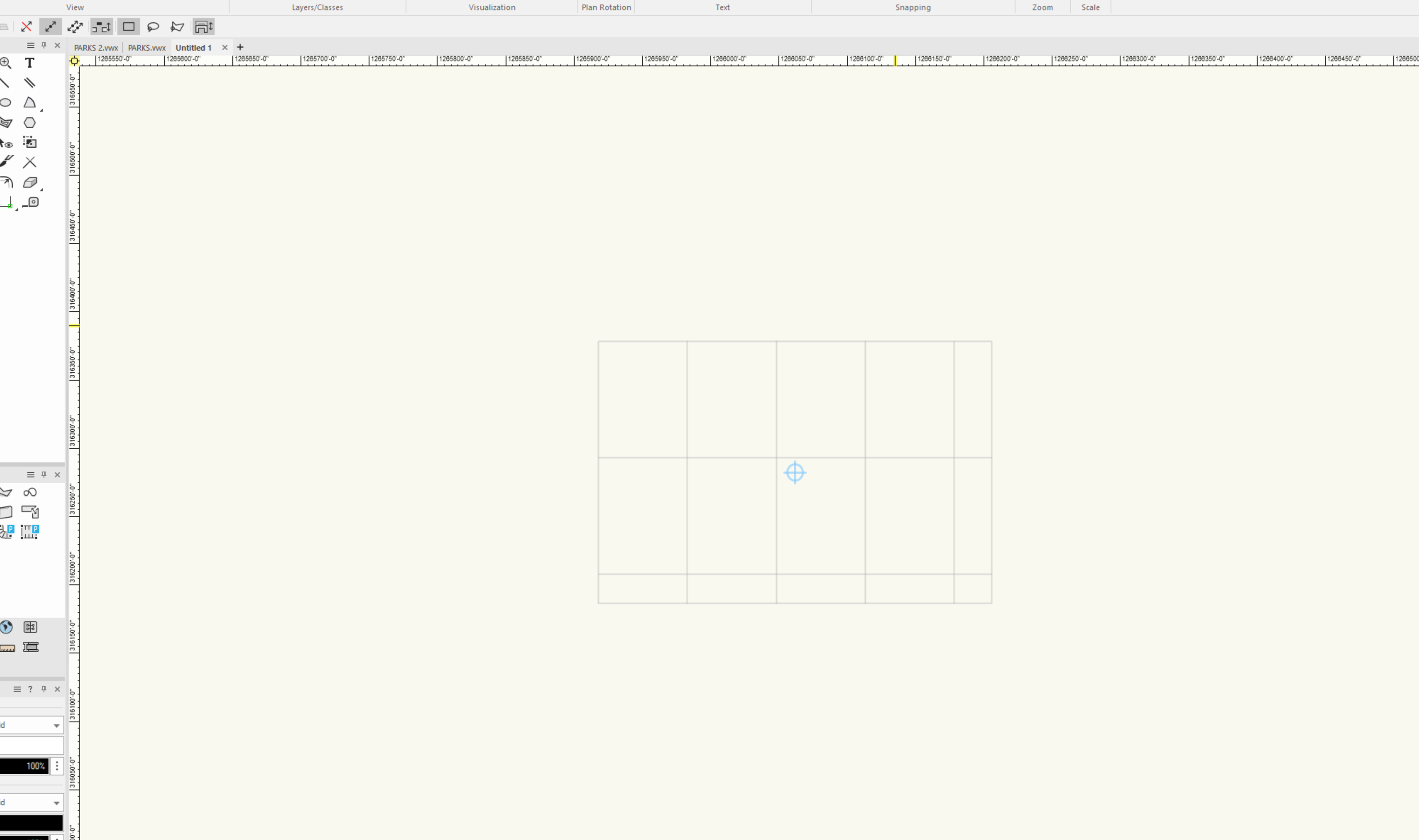
I have inherited a template that I need to use with the company I am working with. It appears to already be georeferenced. In the pic below, the rulers are showing 1266050'-0"/316250'-0". It looks like they might have taken a working file, deleted the drawings, and turned it into a template. I think it may be throwing off any new import data that needs to be geolocated. Is there a way I can set the template back to 0/0? I really don't want to recreate the template . . .

-
lrucker joined the community
-
I am having this same problem with the tab bar when I work on screen 2. I work remotely half the time and my primary screen is on a laptop. I need to be able to hook up to a larger screen and have all the tools there.