
deadtomorrow
-
Posts
57 -
Joined
-
Last visited
Content Type
Profiles
Forums
Events
Articles
Marionette
Store
Everything posted by deadtomorrow
-
Great thanks Jeff, I will give that a whirl. Thank you!
-
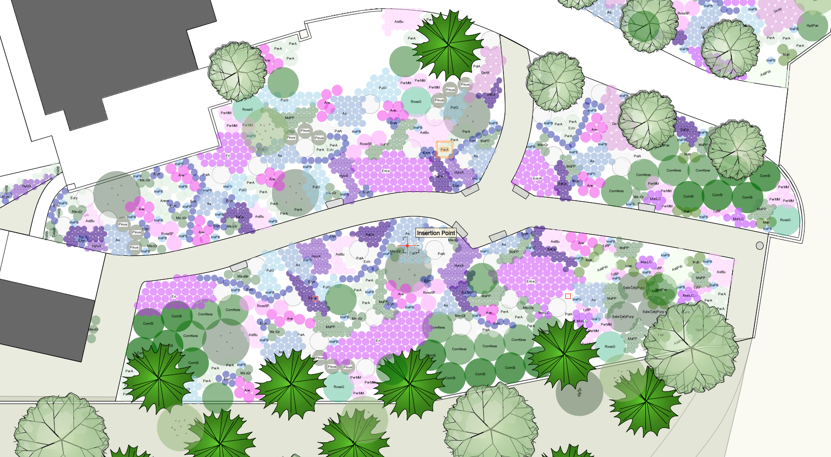
Thanks everyone! Sorry for the slow reply, I posted this and then forgot to check back in the following week! I think the answer is probably here in one of these points about the styles, I'll explore further. Essentially I have a saved document called Plant Library where I've created all of my 2D plant symbols with data. I then made this a favourite in my Resource Manager so that on new projects I can drag in plants from this central file. The way I would like to use them, is for the ID to appear in the centre of the 2D graphic on all of the plants in the Library file, so that's how they appear in the design layer of a planting plan. Then, in Viewport, I'll either keep the central ID or switch it to a data tag. The reason I want to do this is because, with lots of different plant types on the 2D planting plan, it becomes hard to keep track of what each plant is while I'm designing without some data clue visible. I've included a screen grab of a design layer work in progress to show you how I'm working. Back to the problem and my question to explain more: in my plant library I now have hundreds of plants, but they aren't set for the ID to appear on them in a design layer in their centre. I can go into each individually to change this, but wondered if there's a way of selecting them all and going "show the ID in the middle on all these plants"? Thanks, hopefully that makes more sense! 🙂

-
I have set up a plant library file but realise I set up the tags on the plants incorrectly and would like to make a change to all of them in one go. Is this possible? What I want to do is just set the ID to be shown in the centre of every plant on the library, so this is the default view for me when putting plants on design layers in planting plans.
-
Crashing on sheet view when trying to add plant labels
deadtomorrow replied to deadtomorrow's question in Troubleshooting
That's great thank you! -
Crashing on sheet view when trying to add plant labels
deadtomorrow posted a question in Troubleshooting
This has happened three times now, the first time I lost an hour of work! Very frustrating. I create a Viewport and the planting area comes through nicely onto a sheet. But while I'm adding data labels, it crashes completely at random. Is there anything I can do? -
How to change font size of plant tag?
deadtomorrow replied to deadtomorrow's topic in General Discussion
Thanks Pat, I don't seem to have a Text tag when I go to edit a Tag class. I do seem to have got round it though by creating a Text Style in the Resource Manager, and then adding that to a Tag Class in the Navigation palette. Which sounds like it might be the same or similar thing to what you've suggested but from a different menu. -
I'm trying to show the plant ID as the tag in Design view, but the font is huge, is there a way of editing this? I've found the Tag Class in the Navigation menu and how to edit that, but can't see how to edit the font size.
-
I'm still new to Vectorworks as a landscape designer. I believe there aren't any extensive plant libraries available already in the programme or available online (I think that's right?), so instead I'm making my own. To do this, I have: Saved a file called Plant Library and Favourited this in the Resource Manager so it appears in every document Started creating 2D plants for now, simple coloured circles and saving them as Plant Styles from selection, changing the data for each, which makes sense. Usually I copy and paste and plant, then create a Plant Style from it. In the future I'm planning to make and attach 3D models to each of the 2D plants, but that's a big project. If I want to display an initial on each of the plants in a site plan, E.g. Ger for Geranium or something more specific, would I just type 'Ger' as the plant tag/ID and then somehow select all plants to show Tag centred on the plant components? Does that all sound like I am doing the right set up? I thought I'd check before I go too far. Thank you.
-
Thanks Kwik, I'll have a play around with those.
-
Thanks Bruce, I've played around with it more and I think it's something to do with 3D modelling as I noticed it goes in plan mode too.
-
I know this is a really basic question, but how do I remove the large grey box with X across it, particularly in sheet view? It feels like a background but I can't find it in the preferences or page set up.
-
When I create a new tree symbol, am I supposed to use the Existing Trees tool? I can't see anywhere how to create 'new trees' to add trunk and canopy size etc, so I'm guessing the Existing Trees tool is just badly named?
-
HI Bruce, did you ever find out how to turn it off? It has just appeared for me while playing around with the path tool, now I can't get rid of it
-
Hi Knut, I don't have the answer to your question, but please can you tell me where to access the path tool?
-
Sorry to bump this but just wondering if anyone has any suggestions? Thank you Edit: actually don't worry too much as I'm just going to create my own, just surprised how poor the libraries seem in Vectorworks compared to Sketch Up, unless I've missed them.
-
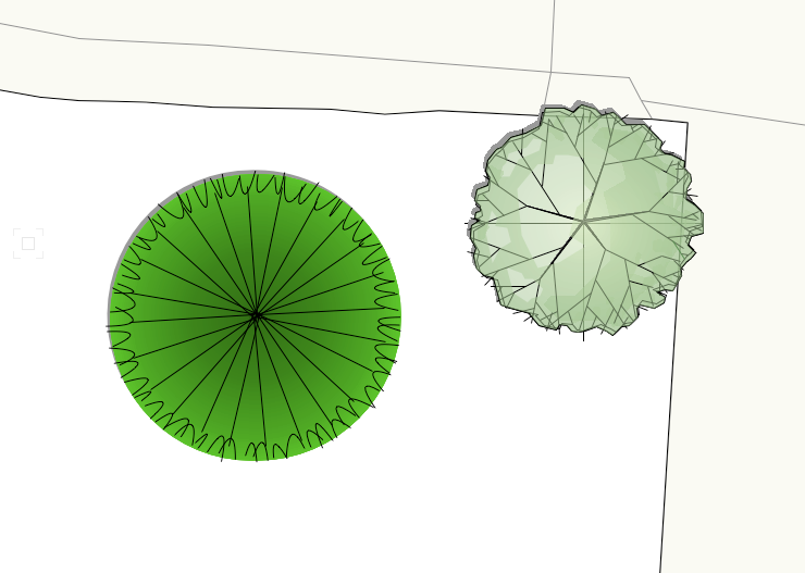
Hi everyone, I was just wondering, are there any other tree libraries I can access for landmark? I've gone into Resource Manager and found the series of folders titles "3D Trees Deciduous" ... "Evergreen" etc but these all seem very inconsistent in style, some are unusable. For instance, I have attached a Pinus sylvestris (not very nice) and a Betula sylvestris, which is pretty good. I also find the libraries very restricted in terms of range of species, though it doesn't matter too much as long as there is just enough variety to represent most plants. I wondered if I am looking in the wrong place or if there are others I can download? My dream would be 3D tree models with a decent 2D design but it seems to be one or the other. Thanks
-
Scale from design to sheet layers
deadtomorrow replied to deadtomorrow's topic in General Discussion
Thanks both, that's reassuring. I felt like I was getting muddled up but it makes sense now, thank you. -
Scale from design to sheet layers
deadtomorrow replied to deadtomorrow's topic in General Discussion
Yes, it's correct in the design layer. E.g. 20m = 20,000mm. -
I'm getting confused about scale (as I usually am!) Please can I check what I am doing is the correct, or most common, way? At the moment I have the design layers all set to 1:50 and import surveys and maps at this scale. So in design, an imported survey is much bigger than the sheet of A3 paper shown on screen, for instance. Then, when I send a viewport to a sheet layer, the full site is bigger than the printable A3 sheet, so I resize the viewport as an object to a scale of say, 1:1000 to get the full design to fit onto an A3 sheet. Or I could change the size of the printable sheet to fit more on at the original scale. Is that the correct way or doing it?
-
Scale and importing surveys and maps
deadtomorrow replied to deadtomorrow's topic in General Discussion
Thank you, this approach makes total sense to me too, I'll do that (sorry for all the questions I'm still learning!) -
Scale and importing surveys and maps
deadtomorrow replied to deadtomorrow's topic in General Discussion
Thanks Tom, that makes a lot of sense to me. This is a really basic question, but in the design layers, do you have the Title Block and page outline showing, or is that only meant to appear in the Sheet layers? I think I've set up my template incorrectly, which is why I'm confused as the map is so much bigger than the Title Block and page. I've attached an example. The Title Block and page outline are the dark rectangle in the middle of the map.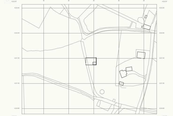
-
Hiya! One thing I've been struggling to get my head around is something super basic with the file set up. I have a template set to 1:50. When I import a survey or map DWG file it’s usually 1:1, so when it imports it's much bigger, which makes sense. And ultimately doesn't really matter as I can work from this in 1:1 and then the viewport scales it. But am I doing this totally wrong and should I be trying to import the files for surveys and maps to 1:50 or resizing them to this? Or should I be working in 1:1. I'm confused! 😄
-
Where to source scale maps to import into Vectorworks?
deadtomorrow replied to deadtomorrow's topic in Site Design
thanks Tom, I'm just looking at that, the OS Mastermap Hybrid looks perfect if it has a scale on it and I can export as DWG, do you know if that's possible? -
Where to source scale maps to import into Vectorworks?
deadtomorrow replied to deadtomorrow's topic in Site Design
Thanks yes, I'm just using it as a starting base and will check all measurements and details on a survey next week. I was thinking of just using Google Maps for the main boundary but I'm not sure how accurate that is? -
Hi everyone! I'm starting a new design for a garden (it's reasonably large at a couple of acres but not too big) and would like to buy a scale map of the boundaries. I've found a few places online offering OS maps etc, but I wondered if anyone could recommend one to make sure I'm not missing out on anything useful or low cost?