


JAMZ21
-
Posts
6 -
Joined
-
Last visited
Content Type
Profiles
Forums
Events
Articles
Marionette
Store
Everything posted by JAMZ21
-
Often we receive surveys with 2D text elevations in meters at varying decimal points. However, the survey and linework are drawn in millimeters. When I use the convert text to Loci networks on the forum, the resulting points are not accurate, because of the change in units. Does anyone know a simple way to select all 3D loci and change the decimal points of the Z value? Alternatively, is it easier to multiply the 2D texts first and then run the text-to-point networks? I'm sure it's an easy fix. thanks
-
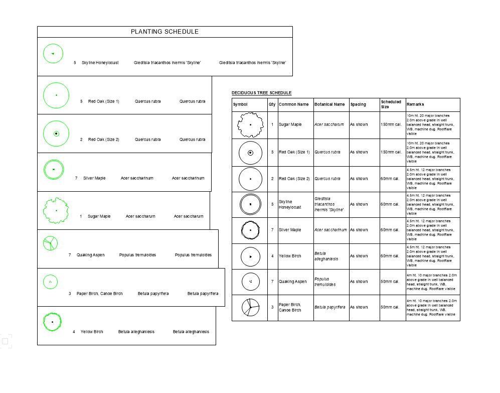
I'm experimenting with moving our planting schedule/legends from worksheets to graphic legends. I'm having an issue with the legend maintaining its size and the symbols aligning all on the center. What settings am I missing? Is it possible to manually adjust the list order? similar to how keynote numbering works? Based on the attached screenshot (the right image) can graphic legends achieve this? and are they ideally supposed to replace worksheets for this level of data? is there a way to connect the symbol with the correct lineweight and viewport setting into a worksheet? I know there is the image function... but it appears broken with not an accurate line weight. The current worksheet looks good. and is achieved by adding individual plant viewports and dragging them into place.. which becomes a tedious movement exercise prone to error whenever that sheet is updated.. I'm at a bit of a loss on how to speed up this documentation and looking for a few answers or recommendations on what is the best practice. thanks in advance
-
Hello, I am using data tags as callouts on planting plans to automate my workflow. However, the tag disappears when I ungroup the planting group to modify the planting layout and then group it again. Meaning I have to re-do the work and copy another data tag to reassign . This task is laborious and can lead to omissions. Can someone please point me to the correct workflow for automating planting callouts? Thanks in advance
-
Hello Dean, I am also learning georeferencing and I just tested this - Note my dimensions are in meters and I am using the projection EPSG 2248 for Maryland. Also verified the runway lengths here: https://www.airnav.com/airport/KFDK I started with setting the EPSG coordinate system - then use geolocate to set internal origin to a point - (I copied the lat and long coords from the corner of airfield on google maps. Then use geoimage to clip out your boundary. In OIP request map tiles and choose appropriate scale. 1:5000.. then draw the line and try measuring. file attached Frederick-MD.vwx HTH E
-
Hi, I am also having the same issue. Has anyone resolved this? VW Landmark 2022 /Windows 11
-
Issues opening 2021 files with 2022 - causing hatch scale issues
JAMZ21 posted a question in Troubleshooting
Has anyone experienced the following? I have a large working file in 2021 that I've converted to 2022. Upon conversion the hatch scales are visually about 100 times smaller (but the hatch scale of the VP is the same as the 2021 drawing) this is happening in all the viewports and across several files, making publishing a nightmare. There is also slow response and sometimes an inability for the scale to update if I try to change it. I have also been noticing a slow response when I select an object and its information to appear in the object info. Restarting VW will help for a while but the issue will return slowing down the workflow... Is this a known bug with 2022? and is there any solutions? thanks.