


kawchman
-
Posts
25 -
Joined
-
Last visited
-
Ok, I see. So just have one retaining wall modifier for the footing and put the retaining edge up to just under the cap of the wall. That makes sense. Thanks, @jeff prince!
-
So the back wall of the grill wall has a retaining wall site modifier so that grade comes down just underneath the cap. When I added a slab modifier to put the footing in, it conflicted with the retaining wall modifier and the grade dropped down to the slab modifier elevation. I want the footing to cut the model but still also have the grade retained by the wall that sits on the footing. Not sure if that makes any more sense. lol. It's not a huge deal. Do you know if VWX is thinking of making a footing detail option for the wall tool?
-
Ok, so you can have two retaining wall site modifiers on top of eachother? Or am i misunderstanding?
-
 kawchman changed their profile photo
 -
Creating a landscape area from shapes ends up crashing vectorworks
kawchman replied to kawchman's topic in Site Design
@Katarina Ollikainen, Thank you so much! I just sent it in an email so let me know if that works and if not, I can put it on the cloud or share a dropbox link with you. Thanks again! -
Help_Why the landscape area cannot texture bed on the proposed Site Model?
kawchman replied to lixinpm's topic in Site Design
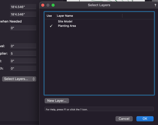
Hey, First issue is that your drafting isn't quite accurate. One of your landscape areas was over the boundary of your site model. Secondly, if you go into the site model settings and choose "use site modifiers on" > "custom set of layers" and then choose the layer that your landscape areas are on, then your site model will accept the landscape areas as site modifiers and they will sit within your site model. I attached a couple screenshots of how I got it to work.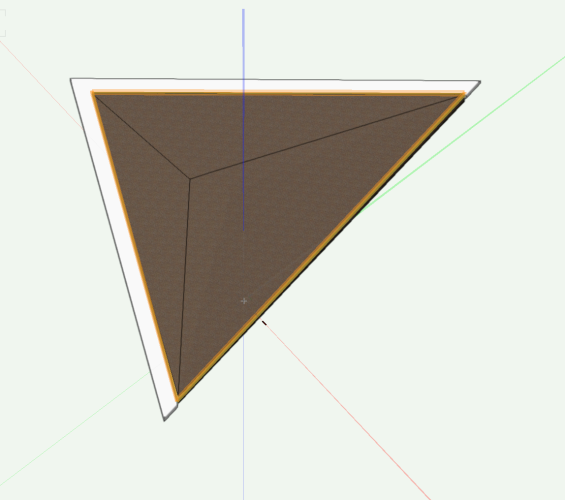
-
Creating a landscape area from shapes ends up crashing vectorworks
kawchman replied to kawchman's topic in Site Design
Ok so here's a screenshot of what I'm talking about. It works when the datum is set at the bottom of the top component (the mulch). When I change that datum setting to "top of the component" and then update the site model I get the spinning wheel of death. Wish I could upload the file. The other thing to know is that it's sandwiched between some aligned site modifiers but I have the same situation going on in other parts of the model and it's not an issue. Thanks!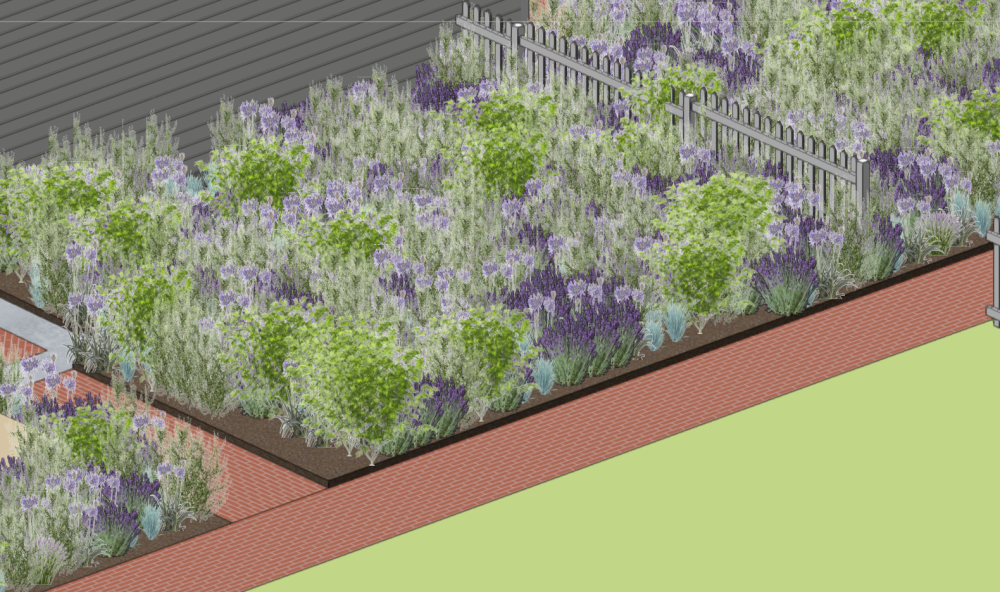
-
I'm trying to create a landscape area from a polygon that I created and using the same process I did for some existing landscape areas on my site model. For some reason I have this one plant bed that I am trying to turn into a landscape area and when I try and update my site model it just spins and freezes vectorworks. The particular landscape area I'm using for some reason has the datum set to the bottom of the top component so it sits 3" above the surface around it and the program always freezes when I try and update the site model after changing that setting in the landscape area style. I have tried attaching the file like 3 times to see if someone else could give it a try but that's not working here either. Maybe it's just time to call it quits for the night.
-
First off I love the aligned pad tool and it's been helping a lot but I feel like I'm missing something in my workflow to get the results I'm looking for a bit faster and more accurate. I'm sure I'm missing a step in the process but here's my general sequence: - Create objects from shapes or draw directly with the aligned site modifier - I'm never sure where to set the elevation in that field. I tell the pad to only align to a custom set of layers in which I've select my DTM Modifiers layer. I'm not sure if I should delete the source object or not. - I start with one pad or aligned pad that I know the elevation and put that in place and then use the "edit surface modifiers" tool to get corners of the pad set. - When I want to align another pad to that one or between two pads already in place is where I run into issues. I never know which elevation to set the aligned pad to and then when I go to use the grade tool in the edit surface tool it doesn't pick up the elevation from the corner of where the pads are aligned if say I wanted to add a high point in the middle of the one I just put in. I'm not sure if this makes any sense or if I'm using the tool the right way so I've attached my file Ver. 2023 as an example. I'm talking about the area that comes off the deck stairs and I'm trying to grade the site for the staggered patio and walk that needs to connect to the driveway and down to the pool. Likely will need steps to get to the pool. Anyway, like I said, this may not make a ton of sense but any help would be appreciated. I feel like I'm just missing a critical piece to the workflow. 1627190672_Albano-New-JK.vwx
-
Thanks @jeff prince! I was able to actually figure a bunch of stuff out by looking at the preconfigured worksheets. I will definitely be using those as we move further into exploring reporting. For right now I'm just happy I have a worksheet that I can use during schematic design to make sure at least I'm relatively close to budget while I draw 2d polys and assign data in the record format.
-
@Pat Stanford Ohhhhh OK. I didn't realize that it had to be in the database header row. I was putting it underneath like you would in an Excel spreadsheet. I'll test this out. Thank you!
-
So I'm trying to create a worksheet that will price out areas like patios, plant beds etc... based on polygons that I have a record format attached to. The problem is I can't pull from the record format into the worksheet and also somehow add a column that creates an extended price. My record format has fields like Name, Area, Unit Price but I can't figure out how to get extended pricing so that it will update as I am designing and can check in on prices. Thanks!
-
Easiest way to drape a property line on a site model?
kawchman replied to JonKoch's topic in Site Design
Yeah you're right. The only thing I did notice that I could do is if I used the property line tool and use it as a texture bed, I can go into the OIP and turn it to "none" to have it not display on the model and then turn it back to texture bed and update the model and it comes back on. I suppose I could use this for the other situation I was talking about but probably a little unorthodox. -
Easiest way to drape a property line on a site model?
kawchman replied to JonKoch's topic in Site Design
-
Easiest way to drape a property line on a site model?
kawchman replied to JonKoch's topic in Site Design
@jeff prince Thanks for the info! I agree, it's kind of a shame you cant just show it as a line. Maybe I can give it like a grass texture to differentiate it from areas that aren't buildable i.e. outside of the property line. Thanks again! -
Hey Thanks! @Benson ShawI think it's the grade limits that were throwing me off. I used to apply a grade limit to a site modifier every time but I just tried creating one big grade limit around an area just as a test and everything seemed to work out pretty well. I just had to poke around a bit more. Thanks again!
- 2 replies
-
- 1
-

-
- site modifiers
- site modeling
- (and 1 more)


