jmccain8
-
Posts
55 -
Joined
-
Last visited
Content Type
Profiles
Forums
Events
Articles
Marionette
Store
Everything posted by jmccain8
-
Hi Tony - Is there a way to get the 2D Polygon Tool/Inner Boundary Mode to recognize plants within a landscape area, so that when I use the command it will exclude all the plants and create a polygon of the remaining negative space around the plants and inside other boundaries? Thanks, James
-
Thanks. I ended up deciding to close out my active drawing, and then reopened Vectorworks from the app menu (rather than clicking on my drawing file from the file system). This seemed to do the trick. Now I can see the export file and then my exported plants when clicking on that from within the Resource Manager and Plant Preferences dialog box. But I have to hit Refresh on the libraries from within the Resource Manager before any recently exported plants show up as available. Anyway, however clunky the process, I might be making some progress. Thanks again.
-
Thanks for the tip, Tamsin, but this didn't work for me. It did not create a new file. It wants to open an existing file in the Object Styles\Plant directory. When I checked my Object Styles subfolders, they are all empty, including the Plant folder (in both my Vectorworks 2020 and 2019 folders). My directory path is: C:\Users\jmcca\AppData\Roaming\Nemetschek\Vectorworks\2020\Libraries\Object Styles\Plant On Monday I started a topic titled 'Custom plant catalogs, Resource Manager, Plant Preferences dialog box', but have received no response. I am completely baffled by this aspect of Vectorworks and it is really hampering my productivity. I would love some advice/help in this area (how to get my custom and favorite plants to show up within the Resource Manager Favorites or User Libraries and/or the Plant Preferences dialog box). Might you have a moment or somewhere you can point me for support? Thank you very much, James
-
Can no one help with this? Thoroughly confused, after much trial and error. How do you get custom plant catalogs to show up in the Resource Manager or Plant Preferences dialog box? I am hoping that it's possible to search for, access and select all plant catalogs from within the Resource Manager. Would have thought they'd show up in User Libraries. How do I save them in there? In Landmark/Choose Plant Data Source dropdown box, I am offered two options: Plant Catalog or Vectorworks Plant Database, both which are stored in my Vectorworks user file system. This is the path on my computer for Plant Catalog: C:\Users\jmcca\AppData\Roaming\Nemetschek\Vectorworks\2020\Plant Database. Within this folder, I see a file named "_CatalogFileConfig.xml" along with several .txt files that came with the installation, as well as my own custom plant catalogs (.txt files). The Vectorworks Plant Database is stored in a sub-folder of the Plant Database folder: C:\Users\jmcca\AppData\Roaming\Nemetschek\Vectorworks\2020\Plant Database\Vectorworks Plants, but my computer has also placed a Vectorworks Plants folder within my 2020\Libraries folder, though it is empty. It seems like through my many attempts to understand the plant catalog features, my system has saved the Libraries within my Plant Catalog folders, and vice versa, and same with the Vectorworks Plants folder. Any advice on setting up an ideal file system so that my custom plant catalogs are accessible from the Resource Manager? Thanks, James
-
Plant Data Source: Plant Catalog or Vectorworks Plant Database
jmccain8 posted a question in Troubleshooting
This question moved to Site Design. James -
Include "Images" when exporting a worksheet
jmccain8 posted a question in Wishlist - Feature and Content Requests
Is there a way to get "Images" to export when exporting a "Landscape Area Mass Planting With Images" worksheet (preformatted report)? I'd like the option to expand the worksheet from within Excel, adding info not captured within the Vectorworks drawing/database. But for it to make sense, I need to be able to see the 2D attributes Function/Image info associated with each landscape area. This shows up within Vectorworks, but is just an empty column when opened in Excel. Thanks, James -
Thanks, Pat - Will do.
-
Is there a way to get "Images" to export when exporting a "Landscape Area Mass Planting With Images" worksheet (preformatted report)? I'd like the option to expand the worksheet from within Excel, adding info not captured within the Vectorworks drawing/database. But for it to make sense, I need to be able to see the 2D attributes Function/Image info associated with each landscape area. This shows up within Vectorworks, but is just an empty column when opened in Excel. Thanks, James
-
Ungroup an imported & cropped PDF page without losing the crop?
jmccain8 replied to jmccain8's topic in Site Design
Not in this case. I only have the PDF to work with. -
Ungroup an imported & cropped PDF page without losing the crop?
jmccain8 replied to jmccain8's topic in Site Design
Thank you so much, Mike - Great solution. I appreciate your help! James -
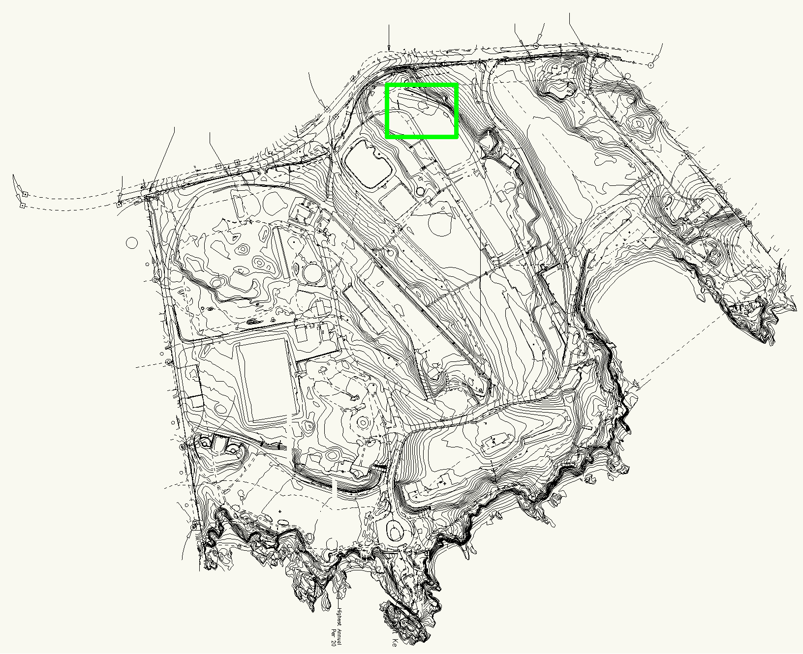
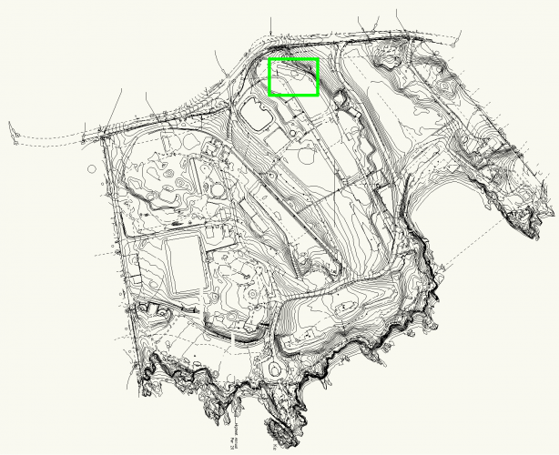
Hello - After importing a PDF vector file (that was created in another CAD program), I used the Edit Crop command to remove everything outside my defined rectangle. After saving the crop, I used the Ungroup command for the selected PDF page. As expected from reading various posts, this left me with a rectangle, a bitmap file, and a group. I removed the rectangle and the bitmap file and then ungrouped the group file. This works except that I have now lost my crop. Any idea why this happened? Is there a way to ungroup a PDF Page without losing the crop? The PDF is a survey of a 90-acre park. I only want to see the info for a 2-acre parcel within the park. The first image is of the crop. The second image shows the ungrouped PDF where the crop is lost. I highlighted in green the area that correlates to the original crop. Thanks for your help, James
-
Thanks, Pat - Great idea on setting column width to "0". So many good workarounds. I'll start a separate topic for the export, though I tried that back in July and received no responses. All the best, James
-
Thanks, Pat - Good to know the limits with Worksheet functionality. Per your suggestion, I assigned a Unit Price to each landscape area, and then added a UP column to the report to sort by. It worked, but I can't figure out how to hide the Unit Price column from the worksheet on the drawing (as can be done in an Excel worksheet). Is that possible here? If not, I'll likely just insert the sort number as a prefix to each Landscape Area Name and then delete the UP column. Here is my updated worksheet: As for the export worksheet problem, yes, the initial dialog box opens for me, but regardless of which combination of selections I make, when I select OK, nothing happens other than a ding sound. Also, I just added my software/OS/hardware info to my signature, which is: Vectorworks Application Version: 2020 SP2.1 (Build 523565) (64-Bit) Operating System: Windows 10 Pro, Version 1903, 64-bit Hardware: ASUS Notebook with Intel Core i7-6700HQ CPU @ 2.6GHz, 16 GB Installed RAM Thanks again for your time and help, James
-
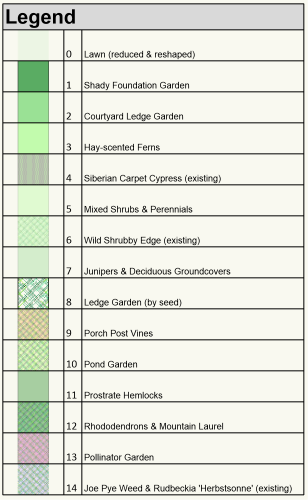
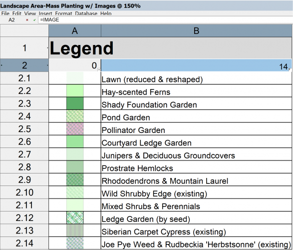
Hi everyone - Using Vectorworks Landmark 2020. I selected and customized a preformatted report called "Landscape Area-Mass Planting w/Images" to create a simple legend. All content is derived from my Landscape Areas (Functions / Image + Records / Name). Here are my questions: 1. DELETE A SUB-ROW: Is it possible to delete or hide a sub-row? When I tried removing one or a few rows, it would remove ALL rows from the worksheet. I can imagine times where this option would be helpful, and simpler than having to go back to the drawing to change Object Info for a particular Landscape Area. 2. MANUALLY MOVE SUB-ROWS: Hoped I could manually drag and drop sub-rows into location within the worksheet, but this doesn't work. In my "Legend" worksheet, using one of the default sort options is not helpful, since I want to sort the rows by hue (or by location on the drawing) to make it easier to cross-reference between legend and landscape areas on the plan. If it's not possible to drag/drop a sub-row, how do I change the sub-row number in order to change its placement in the sequence? 3. EXPORT WORKSHEET: Does not work for me. No matter which file format I select, and regardless if selecting all rows or selected rows, when I click OK my computer makes a ding sound and nothing happens. I don't see any visual message to accompany the ding sound and no popup window appears to enable a file location. James
-
Ah, you got it, thanks! I had noticed that the opacity was set to 5% from the setting of one of the landscape areas recently created, but thought once I selected the report within the drawing and switched the opacity back to 100%, that would work, but it didn't. As you suggested, the attributed opacity has to be set before recalculating. Thanks again, James
-
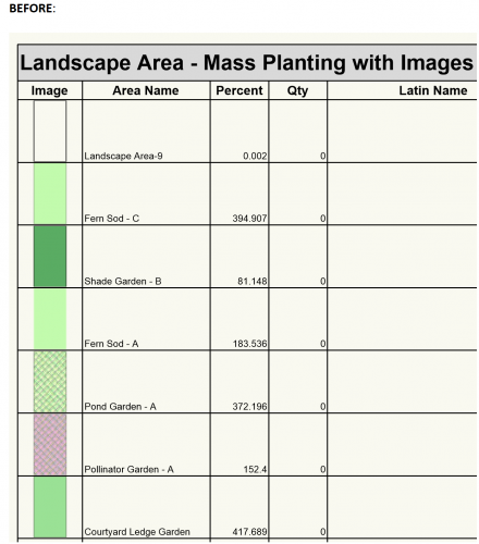
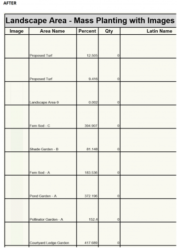
Hello - I am using Vectorworks 2020 and trying to create a simple legend for Landscape Areas, so began by selecting a Preformatted report from Create Report / Type. Below are pasted two screen-captures from my drawing: The one on the left (BEFORE:) is how the report initially looked on my drawing. The one on the right (AFTER) is how the report looks after editing the report and running the Recalculate command. Notice how the images have faded to the point of being nearly invisible. Any known solution to this potential bug? I found a thread from a couple years back, but it didn't help. Is this a known problem, and if so, what is a workable process to create a basic legend for landscape and hardscape areas that will show the image fill? Thanks, James
-
Cannot deselect "Link Pen Opacity" of a Landscape Area
jmccain8 replied to jmccain8's topic in Site Design
Thank you. I'm surprised this wouldn't be an option, but good to know! -
Wonderful! Thank you very much for your help, and happy new year!
-
VW Landmark 2020 on Windows 10. Any idea why I can't deselect the "Link Pen Opacity" of a Landscape Area? I created the Landscape Area from a polyline, and would like the fill opacity at 48% but leave the ink opacity at 100%. Thank you, James
-
Hello - I am using Vectorworks Landmark 2020 and wonder if the opacity of the tag (line, marker and info) can be set at a different percentage from the fill opacity of the landscape area which it is tagging? In my drawing, I have dozens of landscape areas - all on the same layer - but set with different levels of fill opacity. I would like to tag each area and need the tag info, line and marker all set to 100%, regardless of the opacity of areas being tagged. Thank you, James
-
Hi everyone - Using Vectorworks Landmark 2019: Is it possible to export a "basic plant list with images" worksheet? When I click on File/Export Worksheet and click OK, nothing happens except for a ding sound. No error message. If it's not possible to export this kind of worksheet, does anyone have a tip on how I can copy or export the plant images? I would like to include them in a plant list in Excel, rather than cramming a large plant key within the drawing itself. Thanks for your help! James
-
This was a quick and easy solution, thank you!
-
Hello - Using Vectorworks Landmark 2019 and working in 2D only at this time (just learning): Is there a convenient way to define as lawn (turf) all the "negative" areas left between the landscape and hardscape boundaries created in other design layers, and the footprint of buildings, the road, etc.? In other words, all the amorphous space left over from all drawn objects and boundary lines. My hope is that it won't be necessary for me to go back and trace the boundaries of all these other objects, already created by complex polylines composed and created into objects. That would take me a very long time and would be duplicating my efforts. I'm assuming VW has a smarter way. Most important reason for being able to turn all that negative space into a landscape area (turf) is so that Vectorworks can provide the square feet of all that space so that I can calculate required amounts of loam and seed or sod. Attached is a PDF. Note the road at bottom of drawing, from where a polyline runs diagonally to upper left of drawing, then across the top and straight back down to neighboring building and the road, then left along road and up the driveway edge. All empty white space outlined by those lines - up until reaching various landscape and hardscape boundaries - will be turf. Thanks for your help! James Landscape Plan - Create Turf Landscape Question.pdf
-
@Tamsin Slatter Thank you very much, Tamsin. I will view the video and try the pathway mode w/tile fill. I appreciate your help! James
-
Hello. I am a novice and wondering if there is an efficient/easy/quick method for drawing a 2D representation of a path that will be curved, and created from irregular flagstones set at varying spaces from one another? It would be great if there was a simple ability to insert stepping stones (in a resource library) by placing/clicking cursor at a central insertion point for each stone, so that I can eyeball draw a path in CAD that has an organic look. This is just to represent the design for my client and gather the square feet of surface for quoting the install. The contractor and I will hand-select stones from the quarry and improvise as the site and stones dictate, so I'm not looking to actually spec each stone. Thanks for your help! James