


bcd
-
Posts
3,484 -
Joined
-
Last visited
Content Type
Profiles
Forums
Events
Articles
Marionette
Store
Posts posted by bcd
-
-
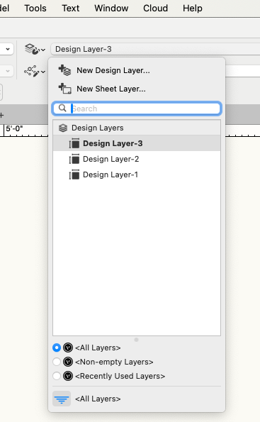
It's not available in Fundamentals
You can use this dropdown or Tools>Organization - not really a hack as this way of navigation has been part of VW for perhaps ever.
-
 1
1
-
-
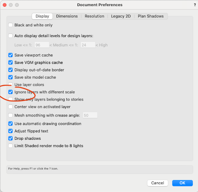
I think what you're looking for is in the Document Settings>Document Preferences
-
 1
1
-
-
no - credits added above
-
1 hour ago, VIRTUALENVIRONS said:
but architecture is Vector-Linear design.
🫣
To the ruler the line
To the clay the world
Perhaps generative design in VW will obviate the need to some degree.
(& a transformative re-imagining of Nurbs and their UI in VW 🙂 )
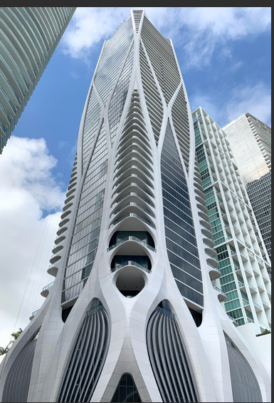
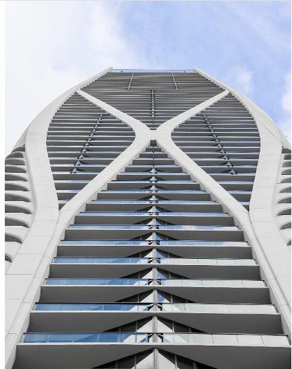
1000 Biscayne Blvd, Miami
by Zaha Hadid Architects
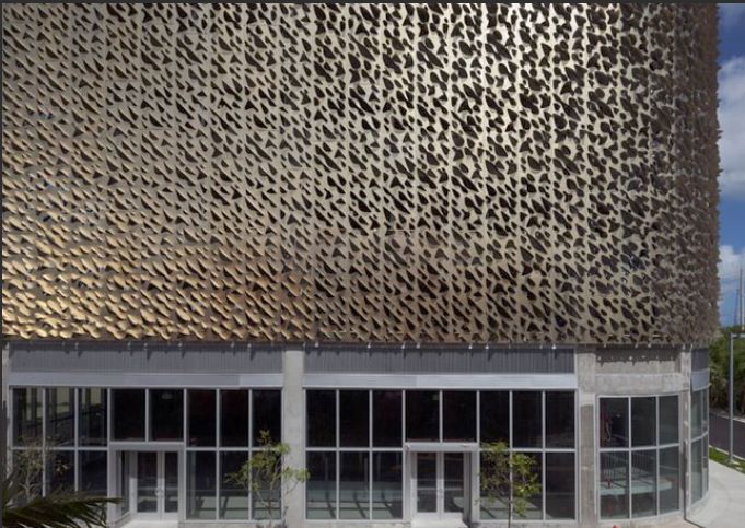
Miami Design District, parking lot facade by
IwamotoScott and Leong Leong
-
2
-
-
It's not removing duplicate 3d Loci, however Purge>Duplicate Objects does.
I just need one 3d locus per X
I don't mind about the 3d Polys - I can switch them off.
-
-
Thanks Pat,
I created a little Marionette to do the trick.

And a little Tools>Purge>Duplicate objects gets the job done. (somehow the Remove Duplicates node didn't work for me)
-
1
-
-
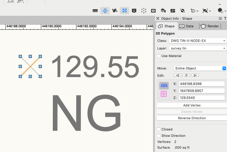
Is there already a command/script that efficiently converts the center of a survey 3d Polygon x to a single 3d Locus for the creation of a Site Model?
eg.:
-
The Curtain Wall is at drawn 8' above 0 while the cut plane is 4' above 0. Change the Cut Plane in the OIP to eg. 10'
-
1
-
-
Did you migrate your workspace. It was a prominent option in prior version.
-
Currently a sparse survey will produce a large triangle TIN site model.
The recommend workflow to refine the triangulation is to place a matrix of 3d Loci and send to surface, then include these 3d Loci in the source data.
The problem with this is that while it results in more dense triangulation - the resultant triangular mesh is coplanar with the original - and the dihedral angle between them remains unchanged.
The wish is to have a SubDivide Site Model button in the OIP to automatically re-flow the surface geometry while keeping fidelity with the original survey points.
-
4
-
-
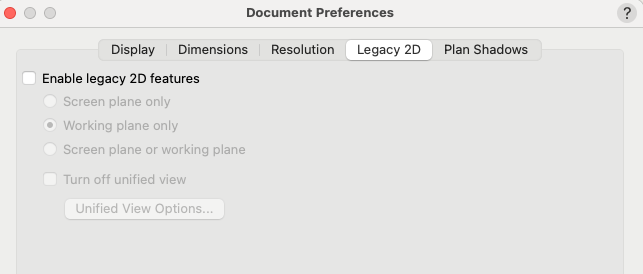
Have you tried a restart?
Is Unified View off by any chance?
-
1
-
1
-
-
I'm not loving this wish as it's currently described. it seems to break the Organizational paradigm somewhat; a blunt tool for the task. But it does point to an significant enhancement that should benefit all use-cases.
Surely there are Sheet Layers where all Classes visible would be appropriate and others selective visibility is appropriate; in the same file. And what if you want all but one Class visible how do you set that for a single Sheet Layer?
With good file structure, important Key & TitleBlock etc. information should never be in jeopardy of being hidden.
Then, while the existing Saved View option seems like a solution, as it's currently implemented it's a bit of a diversion to create a Saved View and use it to access the Sheet Layer. In a similar vein moving from a Sheet Layer to a Design Layer often involves turning on /off Layers etc. to get ready to work, and again Saved Views seem to offer a solution.
Perhaps the focus of the request could be to improve Saved Views, so that they become the primary way of navigating the drawing. They could be created automatically when creating a Sheet Layer, with defaults to show all/visible Classes etc.. Likewise, Design Layers would have the option to have Saved Views automatically assigned.
Importantly the Saved Views UI would need to be updated significantly to elegantly and efficiently present the user with the available Saved Views which the user would generally use to access any Layers in the drawing during all stages of the work.
This would leaving the existing DL and SL organization otherwise untouched.
-
1
-
-
Perhaps a separate Cable Path for each loom?
-
I know you're on Mac, but for others on Windows, I lean towards Lumion, best bang, results, content & speed for the buck.
-
I'm sure a short script would solve it, but in any case It seems an unusual practice to require all Classes to be turned on in all Viewports.
-
1
-
-
Not as automatic as you asked for but quick & easy enough nonetheless:
- Just create a Viewport Style selecting just Classes and enable them all. Then drop this on your Viewport, or
- Alternatively when creating the VP, edit Classes, and Opt-Click the visible column. Presto, or
- You can it globally, by Tools>Organization>Visibilities select all Viewports, enable all Classes.
-
2 hours ago, TomWhiteLight said:
Putting all connected objects (lights and truss) on the same layer
This is a terrible idea, and a seismic regression of Vectorworks' Class & Layer foundations.
It's akin to telling VW Landscape users that the Site Model & Plants & Site Modifiers should be all on the same Layer, or VW Architect users that the Roof & Upper Story walls should be on the same Layer.
-
Maybe the new option could be 'facet curves for HLR'
-
Something to do with intersecting itself too much I think.
If you scale it on the x slightly or change the profile to a circle it works - so I think you just need to tweak it.
The one on the right as a slightly different aspect ration in plan.
-
33 minutes ago, line-weight said:
What have you posted an image of, exactly? That is displaying the curved edges differently from what I get in a hidden line viewport.
It's a hidden line rendering of an extrude, with the corners clipped by a regular 18 sided polygon. It represents how, yes, we would illustrate a curved edge like this with a pencil.
I think this effect would add alot of versatility to Hidden Line Renderings for exactly your case.
-
1
-
-
I think it's just an enhancement request for the Hidden Line. To indicate curved edges with greater/lesser/no degree of linework. Oldschool but very effective.

-
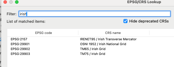
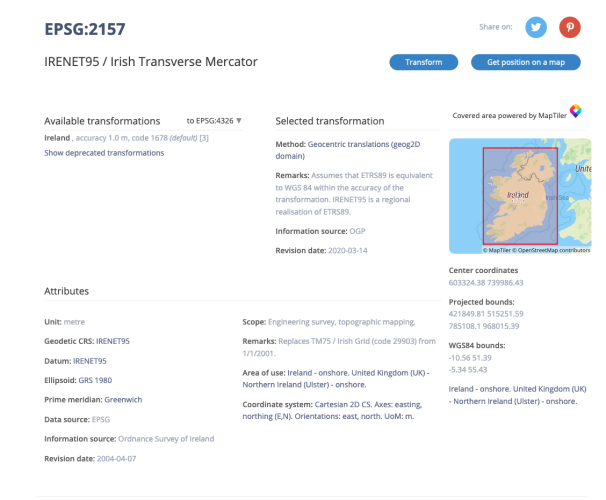
I understand EPSG 29902 TM65 was replaced by EPSG 29903 TM 75 by EPSG 2157 IRENET95
The question I guess is which one agrees with the transformation that the Arcgis is using for the satellite imagery.
I'll run a comparison of the various coordinate systems you mention. I have a feeling that the differences between them, while real, will not be discernible with the satellite imagery that we're getting.
-
2
-
-

Site model appearance with curved modifiers.
in Site Design
Posted
I believe the current recommended workflow is to place a matrix of 3d loci in the vicinity>Send to Site Mode and then cut>paste in place in the source data.
see: