Search the Community
Showing results for tags 'site plan'.
-
Hi All, Rather New to VW. Looking for some input on how to draw my drawing datum in real world coordinates to begin my design development Based on that coordinate point.
-
All, I am trying to learn the best approach to creating property lines / tagging arcs for a "Site Plan". When developing a simple site model, using bearings, I have encountered no issues. However, I am currently working on a plan that is more challenging and requires property lines that have arcs. I have attached what I am working on, and would welcome any support on the project. Thanks, Ryan Russell p.s. - I have a working document that was exported from Revit, and imported into Vectorworks. The problem I am encountering is that it won't scale well when I try to drop in another model created in VW2022. So, naturally, I am trying to see if I cannot just build this out entirely within VW. Property Lines and Tagging Arcs.vwx
-
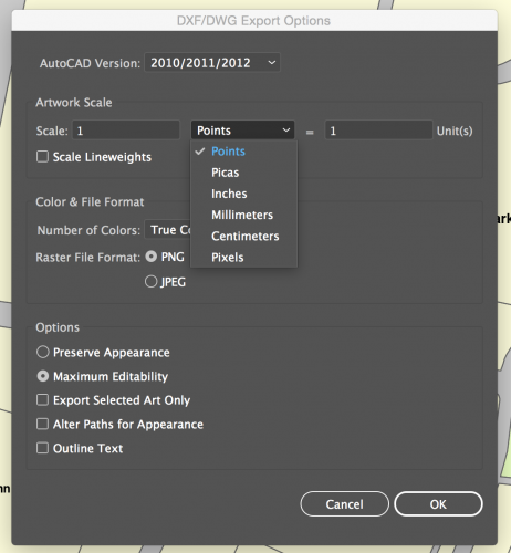
Hello, I'm fairly new to vectorworks i know how to do the basics but now im trying to do a site plan from an autocad PDF so all the vectors are there but I just dont understand how to get the export to scale so I can import it into vectorworks and start working. When I try to export it on illustrator there is an option of scaling I dont entirely understand how it works or how to use it. Please help!
- 1 reply
-
- illustrator
- site plan
-
(and 3 more)
Tagged with:
-
Hello Marionette aficionados... I would absolutely love a tool for drafting all Site related surfaces/areas including Existing, Demolition and New conditions. Basically it would take a polygon and turn it into something similar to a space object, but with a lot fewer functions. full disclosure: I do not know marionette Preface... Site Plans seem simple, but to fully coordinate all the information that gets put on the Site Plan is pretty intense. Our building department makes us fill out very detailed worksheets. They want to know the area of everything. Getting this info correct is the sort of thing that slows you down to a crawl when you're getting ready for submittals. Description of Tool... One of the biggest benefits of this tool, would be that you could make all of your site surfaces on a single class, let's say "A-SITE-AREA", and allow a lot of graphic changes and record keeping to be bundled into the tool (similar to a space object). But it doesn't need to be nearly as complex as a space object. Space objects are a bit heavy and clunky, and I think drawing a siteplan using spaces would create an undesirable workflow. The OIP for this marionette would need to control the following parameters: "Surface Type": This list would be pretty long, and would cover all of the site classes we currently use when drafting a site plan. It needs to satisfy the basic Architectural, Landscape and Civil design elements. You would still need all these classes in the document, it's just that you wouldn't have to constantly be switching to different site classes as you drafted. Instead, the tool would allow you to link each surface category to a specific class, so that the pen and fill properties belonging to each category could still be independently controlled by separate classes. It would be like how door and window component graphics work. You can link each one to its own component class, or you could choose the object class to keep things simple. "Existing", "Demolition" or "New" ("New" would be the default): Including this function means that each surface category would potentially need 3 separate options for class assignment, one for Existing, one for Demolition, and one for New. Having this single feature hardwired into the tool would save a ton of drafting work. It would also make Site Data Tabulations a lot easier. "Pedestrian" or "Vehicular" (for hardscape surfaces): This wouldn't effect class assignments, but would be needed for Site Data worksheets. Yes, we're asked to provide this information in some jurisdictions. "Permeable" or "Impervious": This also wouldn't effect class assignments, but would be needed for Site Data worksheets. Turn Line Work On/Off: Turn Fill On/Off: Duplicate Line Work: An important feature would be the ability to push a button and get the polygon line work redrawn, removing it from the marionette object, and put onto the appropriate class associated with the surface element it represents. You would want to be able to select multiple surface objects all at once, and then run this command, putting the resultant line work into a group, so it could be easily selected and moved to a different layer. Duplicate Fill: The same goes for the fill Add Label Display Name/Title Display Area Is all of this achievable with marionette? Thanks! Matt Regarding Landmark... I know that Landmark has a Hardscape and Landscape tool that is similar to what I've outlined. If I had Landmark, I'd probably be using these tools. I recently posted to the Site Design section about this to see if I was overlooking something in my version (see link directly below). But there's nothing in Fundamentals or Architecture that does any of this for us. So now I'm turning to all you marionette aficionados... I'm hoping we can make something even better using your skills!


