Jump to content

Search the Community

Showing results for tags 'north'.

  • Search By Tags

    Type tags separated by commas.
  • Search By Author

Content Type


Forums

  • Announcements
    • Announcements
    • News You Need
    • Job Board
  • Feedback
    • Roadmap
    • Wishlist - Feature and Content Requests
    • Known Issues
    • Wishes Granted / Issues Resolved
    • Forum Feedback
  • General
    • Troubleshooting
    • General Discussion
    • Architecture
    • Site Design
    • Entertainment
    • Vision and Previsualization
    • Braceworks
    • ConnectCAD
    • Energos
    • Rendering
    • Workflows
    • Buying and Selling Vectorworks Licenses
    • Hardware
  • Customization
    • AI Visualizer
    • Marionette
    • Vectorscript
    • Python Scripting
    • SDK
    • 3rd Party Services, Products and Events
    • Data Tags
  • Solids Modeling and 3D Printing
    • Subdivision
    • Solids Modeling
    • 3D Printing
  • Vectorworks in Action
  • Archive
    • Resource Sharing
    • Machine Design

Calendars

  • In-Person Training - US
  • In-Person Training - UK
  • Coffee Breaks
  • Essentials Seminars
  • Webinars
  • Community Groups

Categories

  • Knowledgebase
    • Tech Bulletins
    • Troubleshooting
    • Workflows
    • How To
    • FAQs

Categories

  • Marionette - Objects
  • Marionette - Networks
  • Marionette - Nodes
  • Marionette - Menu Commands

Product Groups

There are no results to display.


Find results in...

Find results that contain...


Date Created

  • Start

    End


Last Updated

  • Start

    End


Filter by number of...

Joined

  • Start

    End


Group


Occupation


Homepage


Hobbies


Location


Skype

Found 2 results

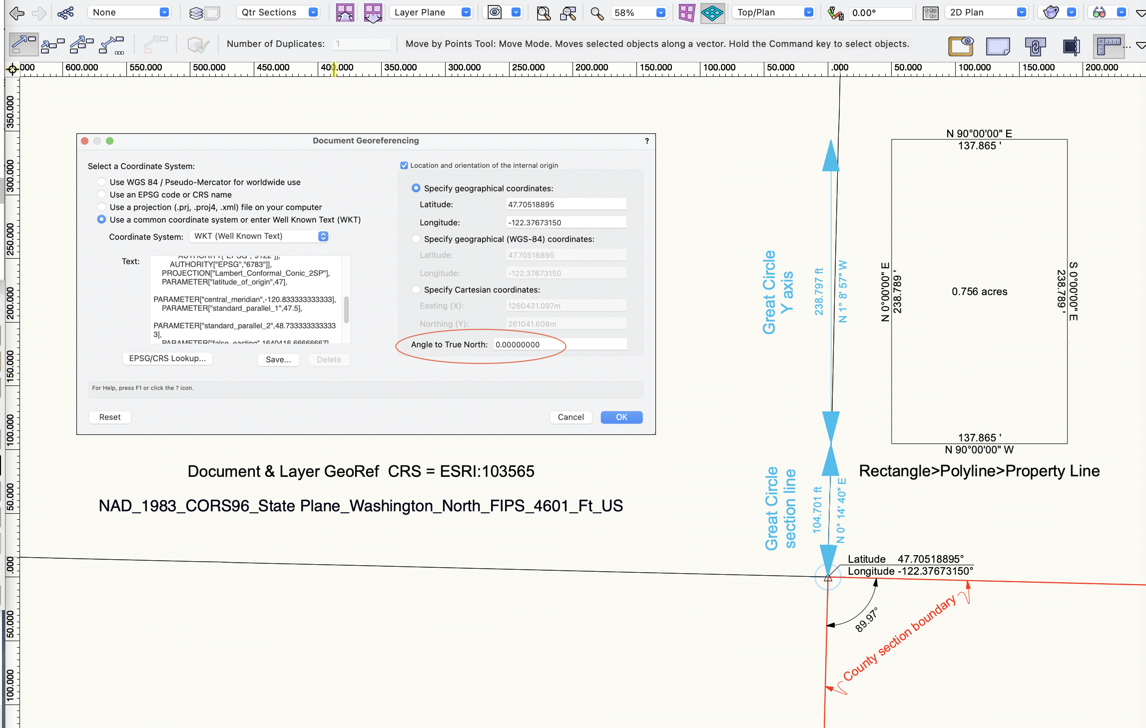
  1. Trying to understand North in georef context. In the example image, the file has a US Washington state plane CRS as noted. County GIS data portal provides the section and quarter section geometry and data. VWX internal origin and user origins are moved to NW corner of the section of interest. This all lines up nicely with the ESRI geoimage and street map. Some comments: TopPlan xy geometry, eg the property line, shows north always parallel to the y axis. I think that's good. Or should it lean? Section lines in USA can adjust to local topography, but idealized version is a square mile with edges on NS and EW. The quarter sections from this township do not georef closely to north. Noted that public maintained GIS data is not presented as highly precise. It's not same as commissioned property survey. The data portals all have warnings that it is more for cartography and not basis for legal or real estate transactions. So, grain of salt on these geometries. Great circle north varies about a degree from y axis at the internal origin. Is there somewhere in the drawing where great circle north is same direction as y axis? eg at the CRS meridian? how to find that? Relocating a great circle east/west (eg drag or move by points) changes its bearing. That makes sense, because the bearing must adjust to maintain the connection to the polar rotation points. So, a few questions: In a survey withp roperty boundary bearings and distances, and CRS/projection notation, is vectorworks xy geometry appropriate, eg the prop line with its bearing notations? What conditions would cause a need to adjust the georef setup angle to true north? Or is this north rotation option sort of a georef version of drawing plan rotation - used for graphic or workflow convenience? I would like to see the great circle tool have editable bearing/distance values. OK, just trying to understand more of the georef features. Thanks for any comment or experience. -B
  2. So I found a cute Compass I want to use for a North Arrow. I use the North Arrow tool and see 10 "Configs" I see the "North Arrow" file in the Resources Browser. I Edit that file and see 27 existing arrows - now 28 with my new one. How do I change the "Configs" to use one of the other 27 arrows? Thanks 🙂
×
×
  • Create New...