


AndrewYVR
-
Posts
8 -
Joined
-
Last visited
-
Event Production/Festival Design Wishlist
AndrewYVR replied to AndrewYVR's question in Wishlist - Feature and Content Requests
I think both ideas work great! I created my own symbol and then I duplicate along pathway. That is my current workaround! -
Event Production/Festival Design Wishlist
AndrewYVR replied to AndrewYVR's question in Wishlist - Feature and Content Requests
Hey Evan!!! That's the dream to be able to simply use a polyline to create long fence lines! Thanks for your comment! Andrew -
Event Production/Festival Design Wishlist
AndrewYVR replied to AndrewYVR's question in Wishlist - Feature and Content Requests
I agree Michael! Hopefully, we can get some updates from the wonderful VW team soon! -
AVL -Audio Video Lighting CAD design engineer
AndrewYVR replied to WorldlightPro's topic in Job Board
Hey are you still actively looking for someone? I might be able to assist. Feel free to PM me! -
Seeking Vectorworks Professionals for Event Projects
AndrewYVR replied to midlifenomad's topic in Job Board
Emailed! -
Event Production/Festival Design Wishlist
AndrewYVR replied to AndrewYVR's question in Wishlist - Feature and Content Requests
Hey Justin, Thanks for the reply. While these trailers are used on-site, what I was specifically referring to was porta potties. See below: Every single outdoor event will rely on these for the public which is why I thought it would be great to have a symbol for both a regular porta potty (as depicted above) as well as an accessible version for the patrons that require wheelchair-accessible washrooms. Best, Andrew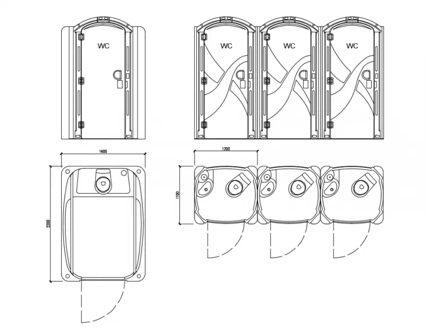
-
Event Production/Festival Design Wishlist
AndrewYVR replied to AndrewYVR's question in Wishlist - Feature and Content Requests
Thanks Josh for your response! I have made my own portable toilet symbols as well but it would be nice to have them standardized in the resource managers for anyone to use especially for those users who are new and want to be able to drop and go. The tent tool would be a game changer. Tents are one of those items that are always used in events. Understanding that not every tent can be captured in the tool but having the option to create simple and standard-size tents (ie: 10x10, 10x20, 20x20, 20x30) would greatly help speed up the drawing process. The way I see this tool working is similar to the "Door Tool" in VW. You can click the "Additional Settings" button at the top and then add in your parameters such as size, height, style, and wall location/size. Regarding the fence tool, you nailed down exactly what I think event profs need. Having to draw my own symbols and placing them in one by one or mirroring a set of panels, takes up quite a bit of time. Being able to draw one line and have the software fill it in based on standardized fence panel lengths would be awesome. Similar to the tent tool, having a customizable section (ie: fence panel length, height, foot configuration, even a scrim option) would be amazing to get accurate totals to suppliers. For the webinar, it would be great to show users how to create base maps with both Google Maps imagery or ARC Gis map data. Depending on the area I find the ARC Gis imagery can be "iffy" in quality so having multiple options would be great! If you need, PM me and I would be more than happy to show you what I have done as a workaround to see if anything can be integrated! Best, Andrew -
Event Production/Festival Design Wishlist
AndrewYVR posted a question in Wishlist - Feature and Content Requests
After working in Vectorworks for more than 5 years in the realm of event production and planning, I wanted to see if we could get updates/webinars for the following topics: 1. Portable toilet symbols (regular portable toilets and accessible portable toilet symbols which can be integrated into worksheet data for inventory) 2. Tent Tool - Similar to any tool where you can customize each tent by length, width, height, style, wall numbers, and ballasting options (ie: walls on 3 sides or all 4). Also, be able to incorporate tent and wall counts into a worksheet for inventory. 3. Event Fence Panel Tool - Similar to the current fence tool but for temporary fencing (ie: 6' panels, 8' panels, crush barricade, 4' panels etc.) It would be great to also be able to track each in a worksheet for inventory. 4. Webinar on how to integrate VectorWorks Landmark and Spotlight to create large outdoor festival base maps using ARCGis or similar mapping data in Vectorworks! Many event professionals create festivals/events in various nontypical event spaces such as parks, roadways etc. Since this type of base map data may not be available, it would be cool to learn how Vectorworks users can combine Landmark and Spotlight tools, to create proper outdoor base plans to build an event. Andrew
