


minotto
-
Posts
143 -
Joined
-
Last visited
Content Type
Profiles
Forums
Events
Articles
Marionette
Store
Everything posted by minotto
-
Is there a way to itemize each of the wall components in a wall style in the database of a worksheet? I was able to create a worksheet with the wall style showing dimensions, costs, etc without a problem. In the database header, i tried setting the criteria to the class of the component but there must be more to it since it didn't work.
-
Yes that did it. Thanks a lot for your help.
-
Pat, i did try just entering numbers but that didn't seem to work. I must be doing something wrong. Here is the file. Worksheets.vwx
-
Thanks Jonathan. Just to reiterate in case i'm missing something: database header - ='Door'.'UserFld1' Database cell format - decimal, dec. 2 places and comma, leader $ In the same column, in the next spreadsheet row, I tried entering =VALUE('Door'.'UserFld1') but got #VALUE! in the cell. Am i missing something?
-
I'm just learning about worksheets and have learned a lot on the forum. But i can't seem to find an answer to a very basic procedure. I'm creating a Door schedule and have used the User Field 1 in each of the doors for the price. With ='Door'.'UserFld1' placed in the worksheet database header, each of the database subrows have the correct price and have been formatted with decimal and the leader $. But the database header row only shows the number of doors with a dollar sign in front. How would i show the total price of all the doors in the last cell of the column? Is there a better way to do this that i'm missing?
-
Thanks. I'm not sure if i got it right. I'm assuming that by preventing tilting in Google Earth, the aerial view is achieved since there isn't a view or setting for aerial view, birds eye or 3d. But i wonder if the assessor's map reference is off, though other documents showing the property line seem to confirm that it's correct.
-
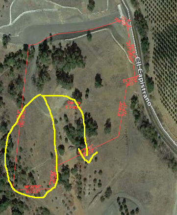
Thanks Jim. Here is a screenshot. The yellow circle encloses the south side of the property line which should be where the arrow is, surrounding the trees. The North portion (top half) seems to be ok.
-
I'm trying to get a rough estimate of where the existing trees are on a site using an aerial photo. After creating the dimensions of a property line taken from an assessor's map reference, i tried importing a snapshot from Google Earth. When the photo is scaled to the property lines dimensions, they don't line up. Is this result of Google Earth photos not being accurate or am i missing something?
-
Ok Thanks Alan
-
Thanks Alan and Jonathan for the suggestions. But i'm a bit confused. Vectorworks can read latitude and longitude but it just has to be formatted according to Alan's example? Or VWs doesn't read latitude and longitude? If so, is there an easy way to convert latitude and longitude to a datum?
-
Thanks Alan. Attached is the text file i used. All the columns seem to be complete. How does it look to you? elevatons.txt
-
I have a text file with latitude, longitude and elevation coordinates separated by commas. I'd like to create a site model from this by converting the information into 3d loci or stakes After selecting AEC > Survey Input > Import Survey File, I tried to selecting various options but the elevations of the 3d loci all end up on top of one another, that is the lat. and long. coordinates aren't recognized. What am i doing wrong?
-
All of my image props of plants i've been using in VWs were saved as a file 3 years ago or so. Somehow it has become a fingerprinted file and i want be able to add to it. How do i do this?
-
Thanks Wes. Apparently this will be fixed in the next update.
-
Attached is a file i'm working on. I can't figure out why plants show up in 2d but not 3d. It seems to only happen in the file in Open GL. Fast Renderworks not a problem. All the classes have been checked. ( Mac os 10.12.1, VWs 2017) 3d_plants.vwx Ok i think i've solved the problem but i don't understand why. The plants are set to a layer elevation of over 2000 ft. When placed at 0 elevation, the plants show up. Why is that?
-
Thanks Alan
-
I know it's possible to create a slab from walls, but is it possible to do the opposite, create walls from a slab or 2d polygon?
-
Does anyone out there in Vectorworks land live/ work in north San Diego county or south Riverside County ? (i do and i'd like to meet for possible collaboration)
-
Ok thanks everyone for the suggestions. Silly mistake on my part. Site Model 3D display was set to Existing, not Proposed. Problem solved.
-
No change.
-
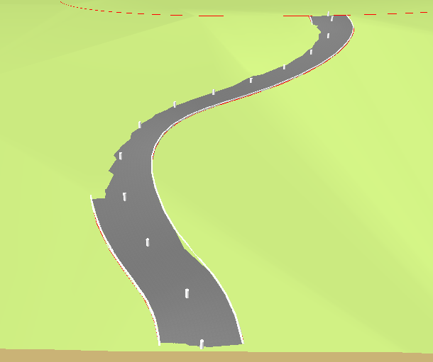
The roadway has grading limits and a pad built into it as an option and i have these selected. I've also tried deselecting and adding a grade limits but to no avail.
-
Yes i did but to no avail.
-
I searched the forum for an answer but to no avail. I'm using the NURBs Roadway tool on a site model with pad and grade limits selected but the site model does not conform to the curve of the road as if the pad and grade limits were not working. Can anyone tell me why?
-
thanks.
-
I'd like to use the handrail that is created when using the stairway tool as a railing around a patio. Is there a way to do this? I can't seem to find that particular hand rail style.
