Search the Community
Showing results for tags 'origin'.
Found 8 results
-
 Hi All, after much pain and suffering trying to find out how to do it I thought I would share how I align my VWs models with lead consultant's (Architect's) Revit model. This assumes the following: You are not lead consultant so you haven't created the shared project coordinates yourself. You are not lead consultant so you are contractually obliged by your client to align your model with the lead not the other way round You are not the BIM coordinator and have received a useless Revit centric BEP. You understand the difference between User Origin and Internal Origin in VW. You understand the importance of modelling close to the Internal Origin to avoid glitches You are doing this before you start modelling. While the steps are the same for after you've modelled, changing the Internal Origin is not advised unless you are being held at gun point by the client. All your sheet layer viewports will be messed up and need reworking. Key message: you need to change the coordinate of your Internal Origin to match the Internal Origin of Revit (which should also be the shared project coordinate). Forget User Origin for now. Steps: 1. Ask the lead consultant (or whoever has set the shared project coordinates) for the Northing and Easting coordinate (relative to British National Grid or your local system) for the Revit Internal Origin. Revit does not recognise your VW User Origin so changing the User Origin won't help align models. 2. Firstly make sure your Vectorworks Document is set to your local coordinate system: File> Document Settings>Georeferencing>tick 'adjust origin and orientation of georeferenced data to match document coordinates' (not sure if necessary). in this window check 'Use an EPSG code or CRS name' Click Lookup and find EPSG 27700 / CRS name: OSB 1936 / British National Grid (or your local system). I had to Google this. Close Document Georeferencing window. This makes sure you are in the correct overall system for Northing and Easting coords (if in the UK). 3. If you now go to your Geolocate tools and select 'Geolocate' while looking near your Internal Origin VW will download and display a satellite image of the world at your Internal Origin. For me this was default right next to the Greenwich Observatory in London. You want your project site to appear here instead in exactly the right location to the mm so... 4. De-select the Geolocate tool (this step was just to demonstrate the location of your Internal Origin in VW relative to the real world). 5. Draw a circle anywhere and type into its centre point properties the Northing and Easting of the Revit Internal Origin. 6. Select the Geolocate tool again and click on the centre of the circle. You get a warning that this changes the Internal Origin of VW but accept it anyway. 7. Now your Internal Origin is the same as the Revit Internal Origin and should be in the 'real' site location. Assuming the Revit user knows what they are doing. 8. Select the Geolocate tool again and hover over the Internal Origin - it should download the satellite image of the real location which should be your site. This step is just to check everything has worked and is not necessary. 9. Head to Tools>Origin>User Origin> check 'Set User Origin to Match the Georeferencing coordinate system'. This just makes sure your User Origin is reset and providing you real coordinates if you have been moving it in the past. 10. Celebrate. 11. if the Revit using lead consultant has also rotated their Internal Origin I am pretty sure you can do so too by heading back into File> Document Settings>Georeferencing and changing the angle to true north here. Edit: the Geolocate tool has a setting option to rotate the Internal Origin. I don't know if it is possible to also change the Z height of the VW Internal Origin but it is less important. Revit seems to struggle with moving IFC models into position manually in the X Y plane but moving it in the Z axis is a relatively simple task and the Revit using lead consultant shouldn't break a sweat over it. I only share my model as IFCs to Revit as you get control over what to export. It is important to make sure your User Origin is set to Northing and Easting 0,0. This ensures you get proper coordinates from your model and you import references in the correct position but also for file sharing across multiple softwares. While Revit only recognises Internal Origin, Autocad and Navisworks seem to use your User Origin when importing. Hope that saves some of you your sanity. Jack
 -
Hi All, We need to align our landscape model with the architect's model and engineer's. Our model is aligned to true north - theirs to orthogonal on the x/y axis of the software. I can position our model in the correct location (very near Internal Origin) while retaining true Northing and Easting readouts by setting the User Origin where it needs to be relative to the Internal Origin. Problem arises where I need to rotate our model to align with theirs. User Origin coordinates do not rotate with the model obviously. Is there a way to not only move User Origin to maintain true project coordinates but also rotate User Origin to compensate for our model rotating to match theirs? Thanks Jack
-
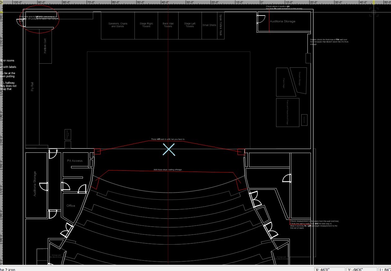
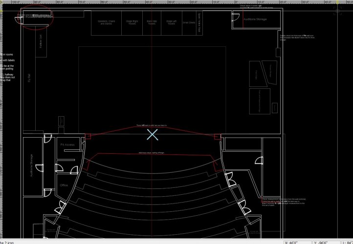
Hey all, This may be a weird one and I hope I can explain it well. I've attached a drawing of the theatre I'm working on with an "X" where I'd like the internal origin to be and where I'd like the drawing to center to when I tell it to center on the internal origin. As far as I can tell, the drawing centers to the internal origin at the center of the drawing itself, not to a random point, but I could also be wrong. I've spent too many hours trying to find an answer, and I have tried setting a user origin where I'd like it and telling the User and the internal to be the same, but it didn't seem to work. I've tried just manually putting it where I want it, but that hasn't proven to be exact enough for my boss. Basically, if there's anything to be done to set the drawing to center on the internal origin any point that doesn't seem to be the center of the drawing that would be awesome, and I hope this all made sense. Thank you all, you're all amazing and I hope to one day have the level of VW skill the rest of you do!
-
 Hi Team. In previous versions of Vectorworks Landmark the User Origin is recognised by the shapefile importer & exporter as the 0,0 point for GIS data. This allows shapefiles to be generated directly from drawings which have an offset User Origin through a previous CAD file import (eg. from a civil engineer or surveyor). You simply georeference the layer to the coordinate system of the received CAD file, and export. It also allows a shapefile imported into an existing drawing based on a previously imported CAD file to appear in the correct position, provided that the shapefile and the CAD file share the same coordinate system. In Vectorworks Landmark 2020 I've found so far that both the shapefile import and export functions ignore any User Origin settings, and handle GIS data relative to the Internal Origin only. This prevents a shapefile from being correctly exported from a drawing with an offset User Origin (through previous import of a surveyors CAD file), and results in shapefile data imported into drawings with an offset User Origin appearing at the wrong numerical coordinates within Vectorworks. Perhaps for technical reasons the introduction of the new Geolocate and Geoimage tools required this separation of GIS and CAD workflows, but it certainly seems like a step backwards in terms of CAD/GIS integration. I'd be interested to hear other's thoughts.
 -
This has happened to a few of us all working on separate drawings now - our drawing information sometimes seems to transport itself way way off grid, with no particular pattern as to why? Can anyone shed any light on this? In terms of our workflow, all of our drawings are set up initially using design layer viewport referencing, to reference in information such as topographic survey, architects / engineers layouts etc, from separate Vectorworks files. All of these referenced layers are set to 'Centre first import, align all subsequent imports' when initially importing into their own files from DWG. Once all of these design layer viewports are referenced (and sense checked that they are in the correct place and suitably stacking on top of each other,) we are then choosing to centre drawing on internal origin, before we begin adding our own information. We then use the design layer referenced viewports as a base to work from to inform our own design, which we draw on a separate layer(s) but in the same position, often snapping etc to the referenced layers and turning things on and off. Sheet layers are created with annotations etc, using both our own layers and the referenced layers. The file can be used for days or weeks working correctly. But then, suddenly we will notice that a sheet layer is only showing annotations and any referenced layers, with none of our own drawing information. The design layer references all remain in their original position, but our drawn information is appearing anywhere up to 250,000km away, and requires to be moved back into place. Is there a reason for this / something we can fix in our workflow to avoid? Or is this a bug of some sort?
- 7 replies
-
- 1
-

-
- origin
- references
- (and 3 more)
-

Vectorworks Origin; how to make it useful to users
mjm posted a question in Wishlist - Feature and Content Requests
It's surprisingly often that I receive drawings from collaborators where their drawing seems to have little or no relationship to the internal or vectorworks origin. When my work is for the stage, my preference is always that the plaster line, proscenium line, firecurtain line or similar be zero, zero. When the job is in a tent, a site location or hotel room, I will want to place everything in relation to a room element, landmark or site-specific item. I find it a trial to turn everything in the incoming drawing on, unlock the locked items and then move it all to where it belongs. It's possible that I can't see the forest for the trees here but… I wish I could tell VW to move the drawing from a click onscreen (or other specified point) to the Vectorworks Origin. -
In VW, I hear that the maximum distance from origin is about 2 or 3 miles. ( it starts to round calculations- all programs have a limit i think) Anything outside of that can make Vectorworks act unexpectedly and give inaccurate information. I sometimes do surveys with VW and once in a while a large job gets much bigger than expected. I called tech support, they were not positive on the real number, is there anyway to find out EXACTLY what that number is so i can make sure i am not having errors? I also hear that some other programs can go about 20 miles from origin. Are there any plans for VW to improve on this anytime in the future? if not, can you mention it to the landmark guys. maybe someday they can make it happen.:)) Thanks ric VW 2017 macbook PRO early 2016 version 16g ram 2gb video
-
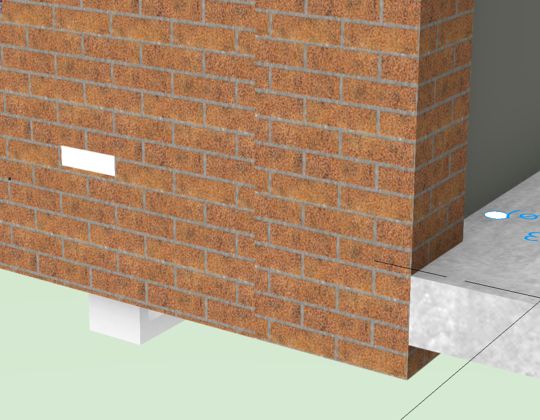
I buggered around with my Storey levels half through a project (removing a Storey for "Site" that was 20 mm below ground floor FFL) and now I have this problem with textures being offset by 20 mm and I don't know how to reset them. In the attached screen shot you can see a new wall I pasted into the file on the right. The texture mapping is 20 mm lower than it should be. The texture on the left is an existing wall. If I copy paste both these walls into a new file the texture mapping will match each other. If I set them both to use World Z For Origin things get even worse. So how do correct/reset all of this in the original file?