Search the Community
Showing results for tags 'stake tool'.
Found 4 results
-

Stake object Easting & Northing coordinates don't match XY
Christiaan posted a question in Troubleshooting
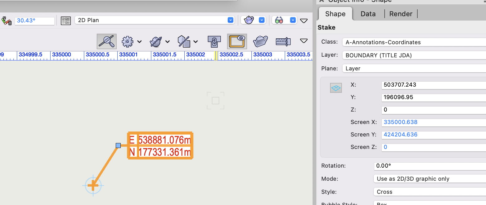
What am I doing wrong here? The easting/northing coordinates of this Stake object don't match the x/y coordinates in the OIP. The coordinates in the OIP are what I'm expecting to see. This is also the Internal Origin. But there's an offset of figures that I don't recognise: X 35173.833 Y 18765.589 I thought maybe because I'm using rotated view. But going back to zero degrees doesn't resolve it. If I change the stake object label reference to "Coordinate Point (XY)" (in metres) it reports the correct figures. test_file_v2022.vwx test_file_v2023.vwx
-
 Right now the stake tool required you to click in the elevation box, enter your elevation then place the stake. I know it does not seems like much but going back and forth to the elevation box then the drawing can be strenuous when entering hundreds of points manually. Having the possibility of a pop up box allowing to enter the next elevation after each stake being placed would be a nice and simple addition. Or Just being able to hit the Tab key to enter the elevation box maybe. Just something that give the possibility to skip going to click in that tiny elevation box would be nice. Thank you kind developing team
 -
 When using the stake tool, you currently have the option to "Set Elev to Site Model" as a way of creating spot elevations for a grading plan. This is great when documenting the surface of a site model for high points and such, but often the elevation we are looking to document is actually a feature such as finish surface, top of wall, bottom of wall, etc. These items are placed on top of a site model, so a stake object trying to query their top elevation will only return the elevation of the underlying site model. There should be a way for the stake tool to recognize modeled elements in the drawing to pull this information into its reference.
- 21 replies
-
- 12
-

-
- site model
- grading
- (and 2 more)
-
I am a boundary surveyor and spend my time trying to sort out peoples problems with the location of their boundary lines. I align my surveys to the (UK) OS National Grid and if we submit the findings to the Land Registry I need to know the Eastings and Northings for each change in direction the boundary line takes. No Z coordinate, only X and Y. Using the Stake tool makes marking these changes in direction really easy, what I would like to do is create a report for each Stake instance with a number and the two coordinates in. Nothing fancy, just three columns. Try as I might I cannot find a way of doing this, is anyone out there able to help, or to suggest another way I can gather this information? VW2020 SP6 on Windows10 Andrew.