Jump to content

Search the Community

Showing results for tags 'slab drainage'.

  • Search By Tags

    Type tags separated by commas.
  • Search By Author

Content Type


Forums

  • Announcements
    • Announcements
    • News You Need
    • Job Board
  • Feedback
    • Roadmap
    • Wishlist - Feature and Content Requests
    • Known Issues
    • Wishes Granted / Issues Resolved
    • Forum Feedback
  • General
    • Troubleshooting
    • General Discussion
    • Architecture
    • Site Design
    • Entertainment
    • Previsualization
    • Braceworks
    • ConnectCAD
    • Energos
    • Rendering
    • Workflows
    • Buying and Selling Vectorworks Licenses
    • Hardware
  • Customization
    • AI Visualizer
    • Marionette
    • Vectorscript
    • Python Scripting
    • SDK
    • 3rd Party Services, Products and Events
    • Data Tags
  • Solids Modeling and 3D Printing
    • Subdivision
    • Solids Modeling
    • 3D Printing
  • Vectorworks in Action
  • Archive
    • Resource Sharing
    • Machine Design

Calendars

  • In-Person Training - US
  • In-Person Training - UK
  • Coffee Breaks
  • Essentials Seminars
  • Webinars
  • Community Groups

Categories

  • Knowledgebase
    • Tech Bulletins
    • Troubleshooting
    • Workflows
    • How To
    • FAQs

Categories

  • Marionette - Objects
  • Marionette - Networks
  • Marionette - Nodes
  • Marionette - Menu Commands

Product Groups

There are no results to display.


Find results in...

Find results that contain...


Date Created

  • Start

    End


Last Updated

  • Start

    End


Filter by number of...

Joined

  • Start

    End


Group


Occupation


Homepage


Hobbies


Location


Skype

Found 6 results

  1. Hi Folks! I'm new to 3D Vectorworks and I could really use some help. Current task is to model an underground parking lot with some 5% mono sloped ramps, some low-sloped slabs (2% to internal drain), and a few filler slabs to join the two types. Desired outcomes: tag/see the elevation markers at the tops & bottoms of the ramps & at the high & low points of the slab drainage tag/see a few interpolated points along the ramps which update when the ramp changes all spot elevation markers and slab elevation input parameters should be actual height - not relative to the floor level So far I've been using the 'hardscape-planar pad' tool for the 5% ramps and the 'hardscape-aligned' tool for the filler slabs. I find it very difficult to control the graphics of these tools, but the 'hardscape-slab drainage' seems to be the worst so I've opted for the 'slab' tool plus 'slab drainage' for the low-sloped slabs. For the ramp elevation markers, I made two data tags - one that displays the 'elevation' parameter and one for the 'elevation at end' parameter, but so far these only work properly if the layer/story height is set to 0'0" so I've used 0' for all parking layer heights. I've discovered that the 'stake' tool can be used to show interpolated grades when applied in a 3D view, but they seem to be static and don't update with the slab. Questions: Generally, does this workflow and use of tools / layer heights / data tags seem logical? Any suggestions to use properly set layer heights while maintaining the functionality of actual heights for design purposes? I noticed the 'slab' objects have a 'Z Ref' option, but I can't change it to anything other than 'Layer Elevation'. How can I change this to another value? How the heck do I change the colour of the slope arrow/text? It's always red despite changing all my project classes to black. It seems that the text within the object is being overridden to be red by default, but I can't change it without going through the right-click menu to 'edit 2D components', but then that breaks all annotation functionality for the object. What the heck am I missing? How can I lighten the drainage lines / text? Both the valleys and slab outline become black when drainage is added. Is there a better way to do add spot elevations in plan view to things like sloped slabs & ramps? Ideally I'd like to drop a tag into the plan and have it display the actual Z-height of whatever it lands on. I'm using Vectorworks 2024.v7 Windows 11 v.24H2 Sorry if any of this is basic 3D VW knowledge, but I've been scratching my head for too long. I remember this all being way easier in Revit, but that was some years ago. Attached are a test file and a screenshot of how I'd like the graphics to appear. Thanks in advance for the help people! 3D Slab & Annotation Test.vwx
  2. Add a default toggle to the Slab Drainage Currently the slab drainage tool work in a way where the height of the drain is the default. I am currently working in the parking and this is actually the contrary of what you are supposed to do. The exterior of the slab should be the default height that stays the same and the drain height varies. Would be great to have a button where you could change this variable setting (my formwork guy will be really thankful) Being able to change the heights of the slab vertex and the slope of the slab drainage In the same idea as the previous one, this would improve so much the tool. Have a class for the slab slope lines Currently the slab slopes line (where 1 slab slope touches another slab slopes, see attaches image) takes the sames class as the slab. This creates a problems in the concrete outline drawings. It would be great if those lines could have their own class. Make the drain tag flexible Currently the drain tag tool has only 1 option/layout. It would be great the the drain tag tool could have an option where we add our custom tag symbols, as the ones for the spaces. Does anybody have other ideas? Thanks
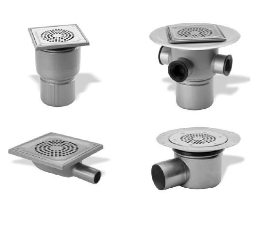
  3. All the default drain symbols available in the Slab Drainage out of the box are roof drains. It would be good to see a few floor gullies in there too, flush with top of slab.
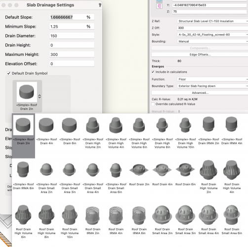
  4. I typically want to define the main slope of slab drainage, not the valley slope. Currently, if I want the main slopes to be a certain figure, I need to incrementally edit the valley slopes until I get the figure I need on the main slope.
  5. I typically want to display slope values as a rise over run (e.g. 1:80) rather than a percentage (e.g. 1.25%).
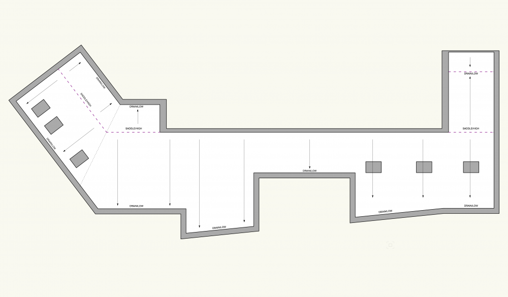
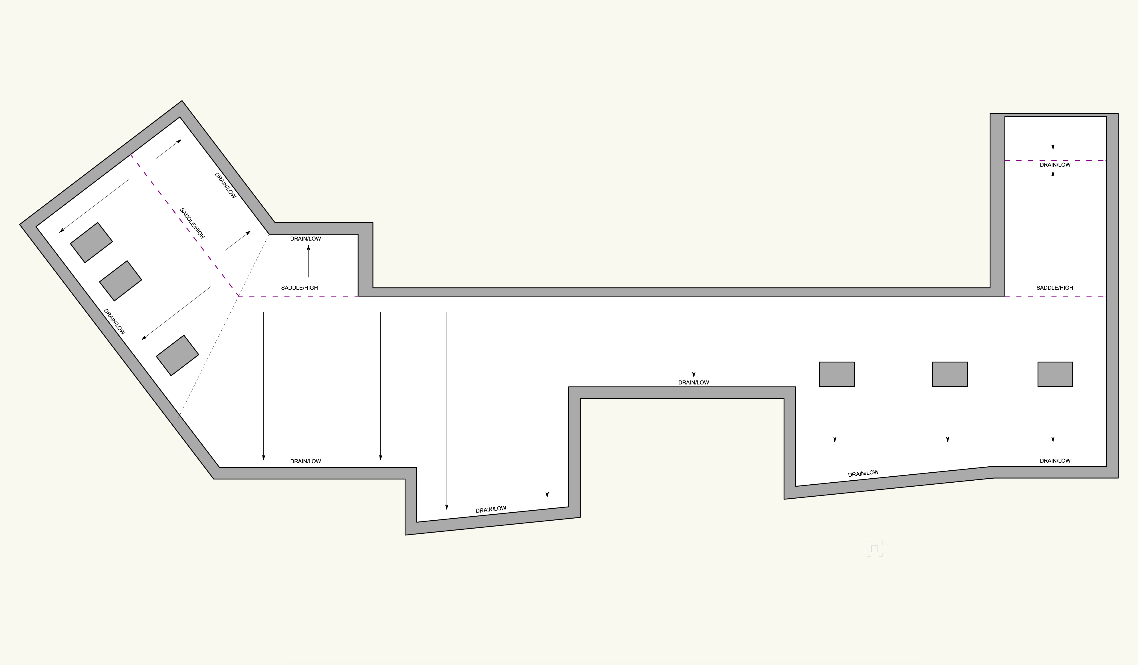
  6. Hi all, I'm currently working on a project that includes a flat roof, and was hoping to use the slab drainage tool to give the falls to the roof, however the shape and falls of the roof is quite complex in comparison to those they cover in the tutorials. Ive tired a few times to get this to work, but no luck. I was wondering if anyone would be able to give me any pointers on using the tool to model this roof, or how to use the tool 'properly'? I've attached a screenshot of the roof shape and where i'd like the saddles/drains to be below. Thanks :) James
×
×
  • Create New...