Search the Community
Showing results for tags 'landmark'.
-
Really like the fence/ railing tool. Would like to be able to insert gates and openings for that matter into the fence much like you can put windows and doors into walls.
-
Hello guys, Just starting to use VW Landmark 2018 with SP1 (PC Windows 10). Every time I edit the contours for the proposed site model (double-click in the site model - "Proposed Site Model Contours") I make the alterations and, when I exit the yellow window, VW just crashes, no error log, it goes straight for the Windows Error window. Same applies even if I don't do any alterations to the model. Anyone with the same error? Suggestions about what to do? Thanks, João Rodrigues
-

OpenStreetMap import for Landmark
Art V posted a question in Wishlist - Feature and Content Requests
It would be nice if VW Landmark (and perhaps Architect as well) could import OpenStreetMap (.osm) vector files. This could be useful when starting work in an area for which one does not have GIS information from the client yet, but you do want to know where housing, roads etc. are. Then OpenStreetMap can come in handy. Also for mapping purposes it could come in handy.- 3 replies
-
- 2
-

-
- landmark
- openstreetmap
- (and 1 more)
-
I have a long, very curvy path drawn in 2d in plan form, which I want to convert to a 3d polygon that I can apply as a pad modifier to an existing site model. However, it is not a flat path in terms of height - it has a crossfall in level and also varies in gradient along the length of the path. I had thought the best way for me to do this would be to convert both long edges of the path to 3d polyline, set the levels for each loci point and loft between the two lines... is this the most efficient workflow? I don't particularly want to have to set levels for each loci point - if there's a way I can set a few and ask vectorworks to interpolate that would be better, but I can't find any tool that might do this? Any comments / ideas?
-
Hi there, I have a survey file of an area of approx 3000 x 1500sqm, with 0.5m contour data (3d polys) and a few spot heights (3d loci). I have validated the data and Vectorworks detects no issues, but everytime I try to create a site model from this data Vectorworks appears to crash (presumably due to area / resolution?) I have extracted a smaller area of the same data as a test, and this generates a site model fine. I don't want to simplify polys, as a.) I don't want to lose definition and b.) simplifying polys causes the contours to overlap and I will have to spend a lot of time re-validating this data. I also don't want to amend my minor contour interval (0.5) as again, I don't want to lose definition. The site model is required for construction information to set levels and calculate cut and fill, so needs to be as accurate as possible. Do I have any other options in terms of creating a model from this data? Is there a typical size of area that Vectorworks can handle as a site model? Does anyone have any experience of the length of time it typically takes to generate a large site model? I work for a Landscape Architecture practice and we are just starting to test the capabilities of Landmark for our work, so good to understand the limitations in advance. I'm currently on Mac OS Sierra 10.12.6, Processor 3.2 GHz Intel Core i5, Memory 8 GB 1600 MHz DDR3; Graphics NVIDIA GeForce GT 755M 1024 MB... running Vectorworks Landmark 2014. (I will put this in my footer for future use!) Thanks, Lisa
-

VW Plant Database - Change in SP4? + How to delete duplicate items
ericjhberg posted a question in Troubleshooting
So we just recently started having problems with our plant database after having it work fine. I'm wondering if a change occurred in one of the recent Service Packs? Without informing users? Before the .exe file and folder used to be called 'VW Plants' and now it seems to be 'Vectorworks Plants'? This seemingly simple shift has me boggled because we track our favorite plants by checking the box for favorites...and they all disappeared. I am able to retrieve my old data, in tact, and find my favorites, but when I try to import the .usr file with just the favorites, I can't seem to select an option that just updates existing records with the "favorites" box checked. Instead, the only way I can seem to get those records in is by adding entirely new and often duplicate records into the database. When I do this I end up with two 'Plant name A's...one checked as a favorite and another unchecked. I want to be able to delete duplicate entries in the database. I have even found ones that come in it stock. Is there a way to quickly purge the database of duplicates based on a specific field (i.e. VW Latin Name)? Or Is there a way to import records from another database and have them simply update the records within the database without adding duplicates...mainly the check box for VW Favorites? -
When pipes are created, they cannot be offset by conventional methods. I understand that this request is more complex considering the network character of irrigation pipes, but for graphic clarity on irrigation plans, this is often a must! Sometimes there is a need to convey that several pipes are running along side each other. The cleanest way of doing this is by an offset. To get around this, we have started by creating our pipes using polylines, and offsetting as necessary before Create Objects from Shapes... into pipes (see this post for my separate issue with this command). This works fine until we have to add another pipe or change something and the original functionality is lost.
-
I would like to request Unit and Labelling for the grade tool similar to the Stake Tool. Units for grading are often not the same as the drawing units. our drawings are usually millimetres and vertical grading units are often metres to conform to the survey units. Also the ability to label a grade is important such as bottom of stair, bottom of curb, etc. Stake has all of these features. We have to double the amount of work in our grading drawings by using the Grade Tool to calculate and show slopes and the use the Stake Tool as a 2D graphic for labelling. Very time consuming.
-
Hi guys, I need some help/clarification, I'm designing an irrigation system with small flower beds (please see the image). Is it correct the way that I'm designing it (connecting different spaces to a single valve)? The program isn't signing any error, but, as it is the first project that I'm developing in VW, I would be grateful for the help. If need, I can upload the file so you can see if I'm not making any kind of mistake. Thank you!! IMAGE.pdf
-
Is anyone involved in Theme Park Design using Vectorworks. Preferably for design of the full park or elements of the park. Any similar venue designs which may be relevant would also be useful.
-
Hi guys, I'm getting started with Vectorworks Landmark 2017 and I'm developing an irrigation plan where I want to use a root watering system (http://www.rainbird.com/landscape/products/accessories/RWS.htm). I'm adapting it as an emitter since I didn't found this accessory in the library. Did anyone faced this subject? Thanks!!
-
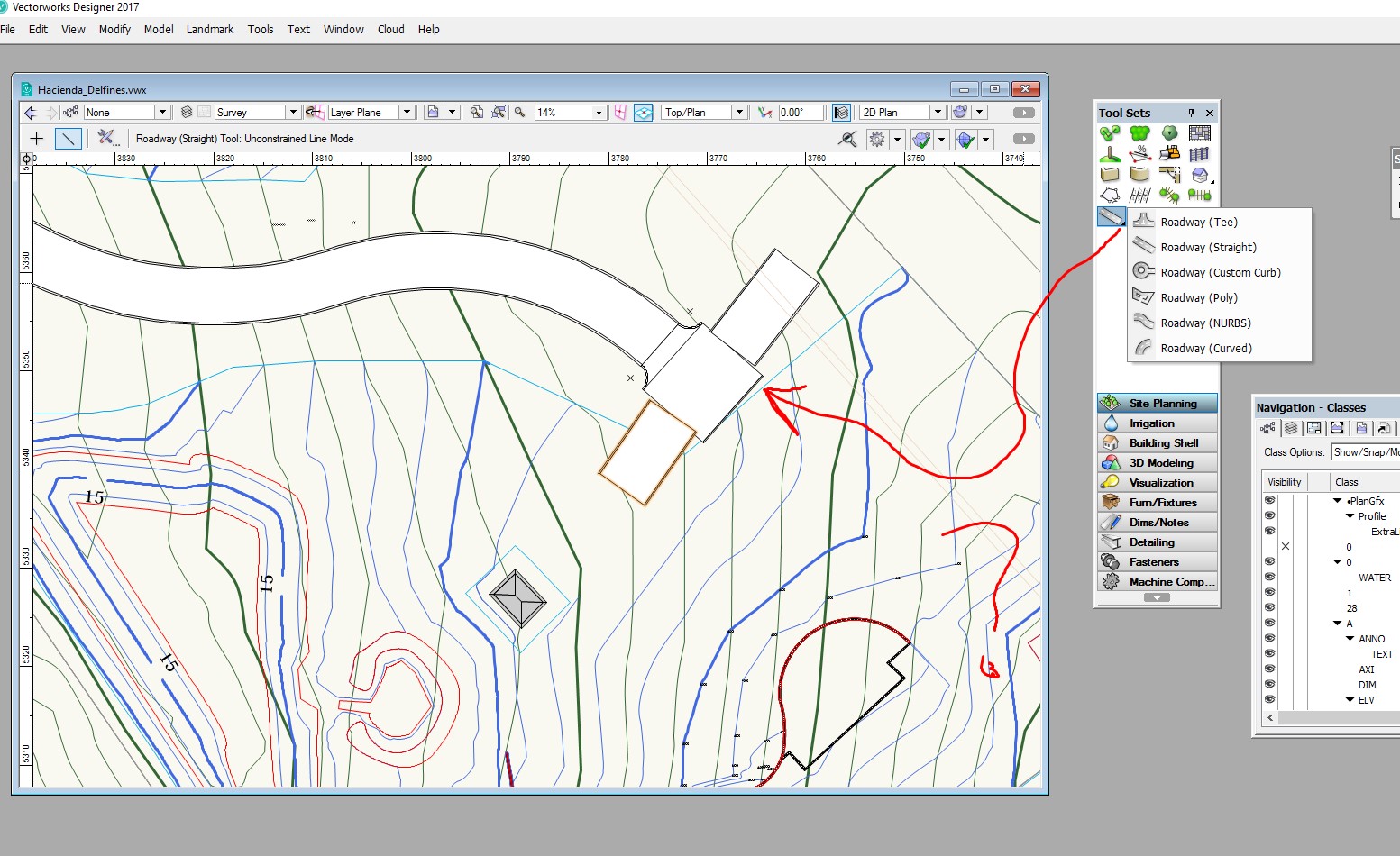
I posted a previous post on this subject but got a limited response. I am simplifying the question this time. It is about the Road Tee command from landmark. I don't see any use of this tool. I align the Road Tee with a straight line , but this is not connecting to the straight line. Therefore, what is the use of this command? Can anyone come here with a good working example? I need to create a network of roads and parking lots connected the peripheral, but not getting too far. I am expecting everything to work 3D and with a site modifier over a site model.
-
I have gone a long way . Need to design my interior roads and parking space. But I am not getting too far. To many problems not been able to join and site modifiers conflics. Please help. here is my problems. In my design , I have 2 roads and 2 parkings. I need to draw the Road T to access from main road to the parking lot. It looks like there are several ways to get there, but I am not getting very far. I use Polyline to draw 2 roads. Then I use the Road Custom command to do the parking area with the 2D Parkign command to create the parking configuration. But , I am not able to join the roads in a T. I created the 2 roads across my property , but not able to get the ROAD Tee to fit and join the roads. I must be doing something very wrong and the documentation doe not help. Here is the link to the VW file. https://www.dropbox.com/s/ro2ke5nzk1dqqh0/Hacienda_Delfines.vwx?dl=0
-
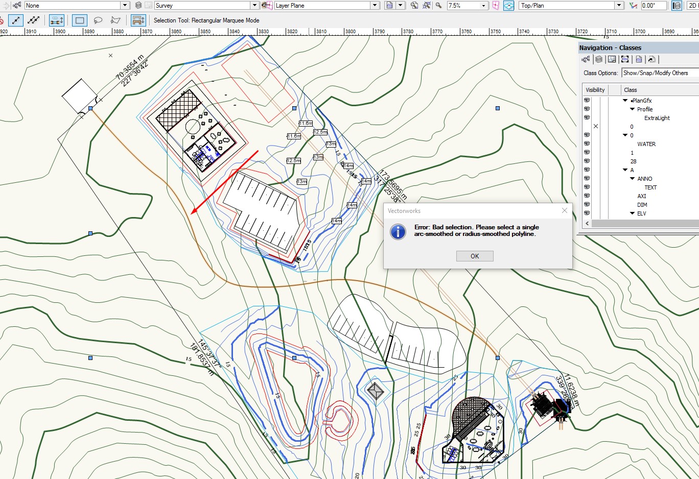
Why I am not able to use the Stations on Polyline command from Landmark?
-
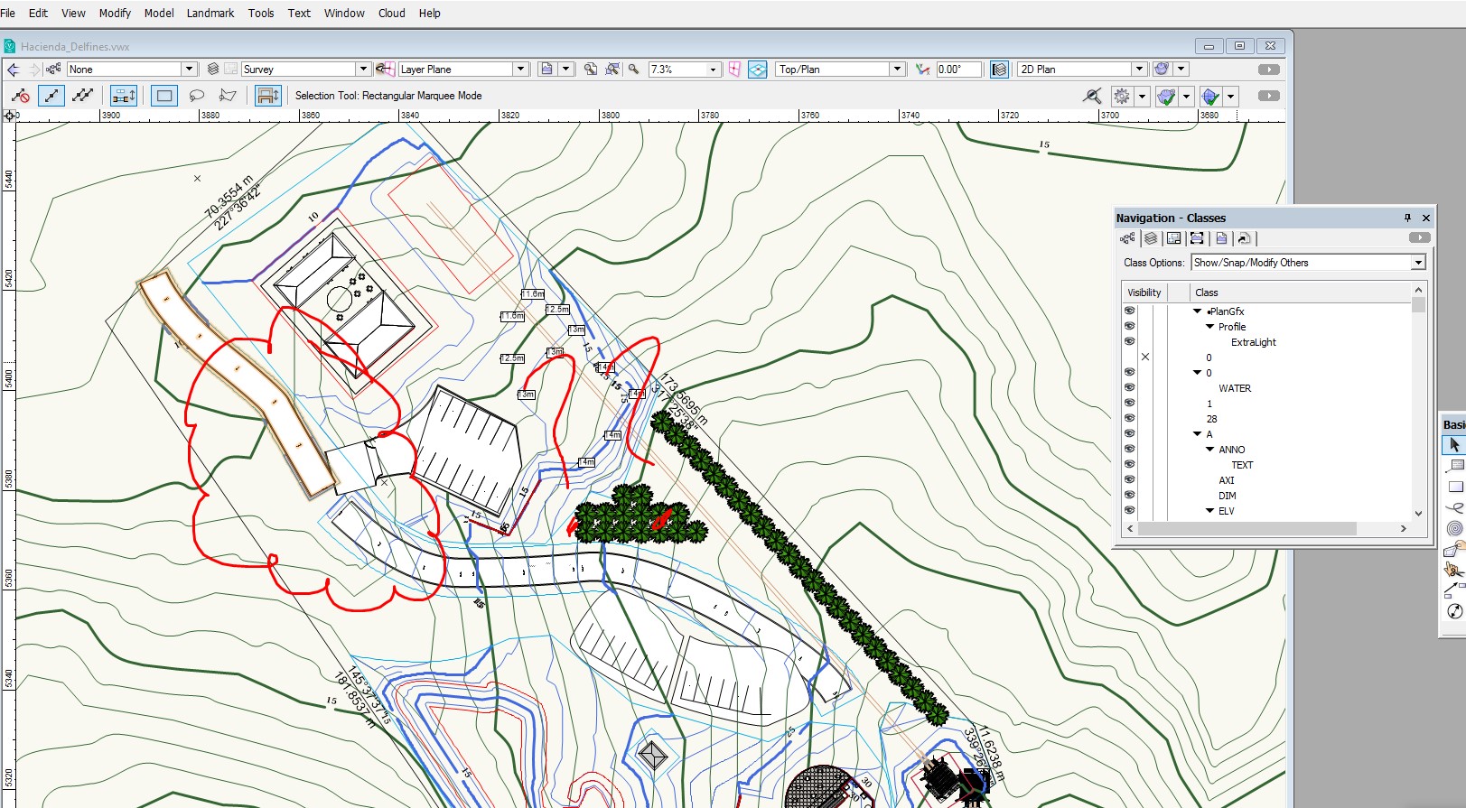
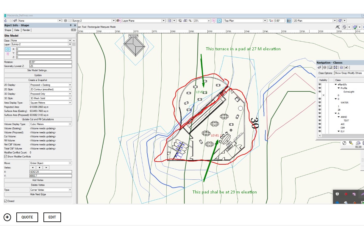
I am working with getting refine skills in Site Modeling. I have a small building resting over a steep hill . I designed one floor building with a terrace at one level and the remaining area steps up into another pad elevation. I have trouble setting the Site Modifier for Pad with retaining wall and normal pad. The problem that I face is that the pad are joined together alone the line that separated both sections of the building returns an error. What technique I need to apply? IS there a better technique to tackle this situation. I sea a lot videos but they don t really take into account Pad modifiers that are aligned one next to the other touching together. Here is a link to the VW drawing... https://www.dropbox.com/s/ro2ke5nzk1dqqh0/Hacienda_Delfines.vwx?dl=0
-
I need help mastering site modifiers tools. I have trouble getting the Boundary limit around a pad. I have set a boundary site modifier for the property limit. Proposed Site Model looks good. But I entered a second smaller grade modifier inside the property surrounding a site modifier pad. But the second boundary limit is not acting as expected. The pad is created but the contour is modified all the way to the outside boundary limit of the property. https://www.dropbox.com/s/ro2ke5nzk1dqqh0/Hacienda_Delfines.vwx?dl=0

-
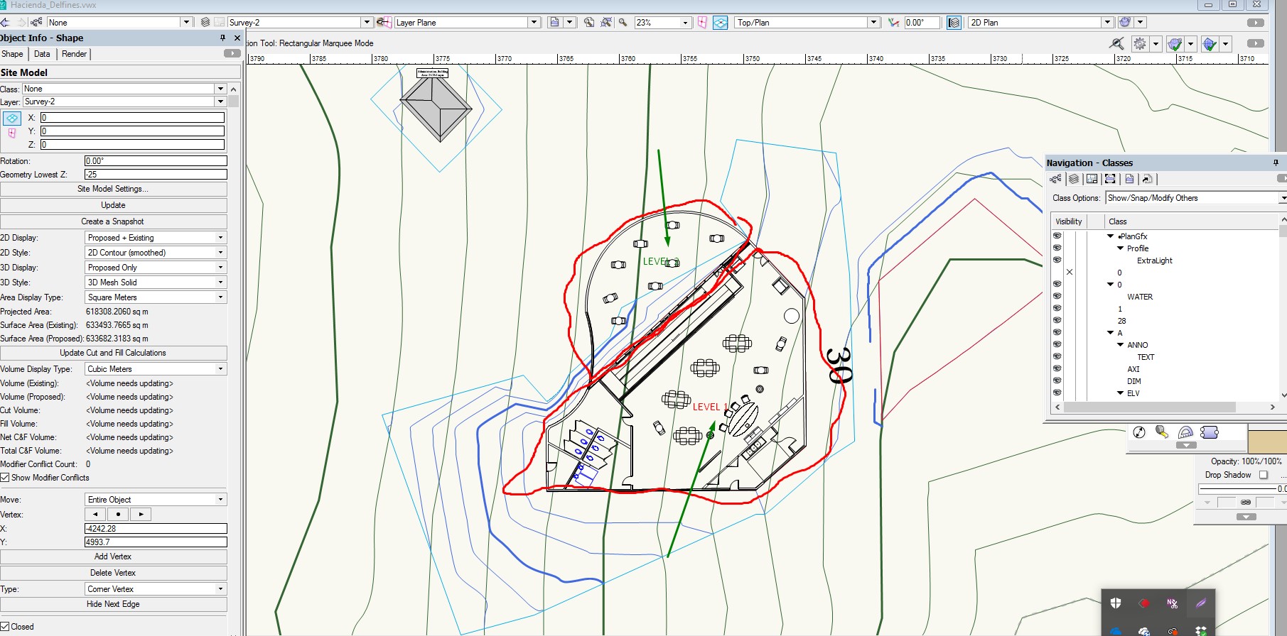
I am working on a site model. I created a site modifier in my mother that later erased. But I can not find why the proposed still shows a grade modification. I have checked the only modifier present is the Boundary modifier of the lot. Please help. Here is the archive https://www.dropbox.com/s/ro2ke5nzk1dqqh0/Hacienda_Delfines.vwx?dl=0
-
I'd like a Smooth Site option for the Site Model. This would do away with the need to Drape Surface onto an existing site model to get the desired effect. The new Smooth Site would interact predictably all the usual Site Modifiers & settings. Ideally the mesh density would auto-adjust to allow for retention of hard-edged features while reducing the overall vertex count. It would be important to retain existing Texture Mapping of Drape Surfaces.
- 2 replies
-
- 2
-
-
- landmark
- site model
- (and 3 more)
-
The program is very unstable and keeps crashing and even after setting up auto save for every 3 tasks, when it crashes I lose all of my work and not able to recover it. I have called tech support about this they seem not to be able to fix it and try to blame it on my computer. I have a very high powered machine with a R 480 Video card and a AMD crosshair V, 8 core processor and 24 gig of memory. So it's not my computer, is there anyone who has had this problem and is there a solution?
-
 I have a site model if a area alone the water front. I am set contour data for areas on the water to be below 0 (negative levels) I will like this surfaces site model to render blue color to allow clearly differentiate between upland and wetland. Here is a link to the VW file https://www.dropbox.com/s/ro2ke5nzk1dqqh0/Hacienda_Delfines.vwx?dl=0
 -
This is a simple and consider a common scenario but not able to get a solution. I created a Digital site model using 3D Polygons that where converted to 3D loci. I am not happy at all with the resulting Contour site model. I realized that I needed to add additional 34D polygons data in order to enhance the resolution of the site mode. But I am not able to return to the original 3D polygon not the 3D loci data. I double click the edge of the contour site model, but all I get is the Site model parameter windows. I do not want to change the model using modifiers. I just want to recreate the site model.
-
 The crux of global design and BIM software developer Vectorworks, Inc.’s philosophy has always involved leveraging input and implementing product feedback from practicing architects, landscape designers, landscape architects and lighting designers, among other design professionals. To further this commitment, three new industry experts will be joining Vectorworks’ ever-growing product marketing team: Luc Lefebvre, senior architect product specialist, Jim Woodward, senior entertainment product specialist and Brian Nicholson, senior landscape product specialist. Led by Jeremy Powell, senior marketing director at Vectorworks, the broad team of industry experts acts as advocates for customers and the industry relating to the marketing and development of products. They provide one-on-one demonstrations of product capabilities, participate in professional association committees and visit firms in the field as a means to generate current insights for industry-specific tool development, as well as act as fountains of industry knowledge for other internal teams. Regarding the new additions, Powell said, “We are elated to welcome Luc, Jim and Brian to the Vectorworks family. With their diverse backgrounds and histories of excellence and service to the advancement of design within the architecture, landscape and entertainment industries, I’m sure they’ll make an immediate impact as champions of our software. And, as recently practicing designers, they’ll bring additional perspective to our team to ensure our products speak to the needs of designers.” Delve deeper into these new industry experts’ skills, backgrounds and career plans. Luc Lefebvre, OAQ, LEED AP BD+C, Senior Architect Product Specialist at Vectorworks Coming from a family of builders, Lefebvre knew he wanted to study architecture from adolescence. He kick-started his journey at Montreal University, where he received his undergraduate degree in architecture. Since then, he’s enjoyed more than 20 successful years in the business. Most recently, he served as project manager and BIM manager at King + King Architects in Syracuse, NY, where he focused on designing educational facilities and acted as a BIM consultant for both internal employees and other firms. Some of his past projects include Le Moyne College Master Plan and Madden School of Business, SUNY Cortland DeGroat Hall and SUNY Morrisville Mohawk Hall. In his office, Lefebrve was responsible for streamlining building information modeling processes and played an integral part in King + King Architects’ company-wide transition to BIM using Vectorworks Architect. This, in part, was his motivation to work for Vectorworks, as he enjoyed moving his firm from 2D to a 3D BIM workflow. Regarding his shift in careers, Lefebrve said, “I felt like I had just scratched the surface of Vectorworks’ capabilities, and I needed to know more about the software. I wanted to help other people experience that same excitement from learning how to do BIM projects with Vectorworks.” In his new position, he plans to narrow in on the BIM process, as he’s an ardent believer in Vectorworks software as the all-in-one design tool because it eliminates the need for further applications in the total design of a project. To explore Lefebrve’s BIM know-how, register for his upcoming webinar, “The Why and How of BIM Implementation,” on February 23 at 2:00 p.m. ET. Jim Woodward, Senior Entertainment Specialist at Vectorworks Woodward is another long-time Vectorworks supporter. With more than 35 years of experience in the entertainment design industry, Woodward began touring cross country as a lighting technician as a teenager and never looked back. He later opened his own design company in Boston, ExhibitLogic, with his wife, Shirley Woodward, where they tackled 3D visualization, rendering and modeling for a wide variety of industries, such as concerts, theatrical events, film, television, corporate events, trade shows, museums, architectural firms and retail stores. From spearheading concert-like booth and exhibit designs for the NAB Show, the Comdex convention and the International Broadcasting Convention (IBC) to touring with artists like Aerosmith, Neil Diamond and Yes, he’s had an illustrious career that has taken him around the world. Furthermore, he has guest lectured at places such as Boston University and Symphony Hall in Boston, as well as worked on productions such as “The Proposal” and “Ted 2.” While Woodward’s day-to-day was never the same in his career, there was one common thread: a passion for technology. He started out using Vectorworks Spotlight early on in its existence and immediately came to realize it as the go-to design software for entertainment design. As he dove deeper and deeper into the program, he discovered his passion for pushing the technology’s limits and became widely known in the entertainment industry as a Vectorworks expert. Eventually, he began regularly providing training and consulting services with the software. “After I gave my first Vectorworks demo, I was on cloud nine,” said Woodward. “All these years, I’d been under the stage, behind the stage, pretty much anywhere but on center stage. It was my first time in the spotlight, and from there, the rest was history.” With his Vectorworks skills so advanced at this point, it was only logical that this was his next career move. In his new role, he intends to be a liaison to help communicate industry trends back to the team at Vectorworks, as well as help intermediate designers take their drawing skills to the next level. To see Woodward in action, register for the upcoming webinar he’s hosting, “Adapting New Technologies to your Production Design Workflow,” on February 28 at 2:00 p.m. ET. Brian Nicholson, ASLA, PLA, GRP, LEED AP, Senior Landscape Specialist at Vectorworks Growing up in the mountains in southern Colorado, Nicholson was ingrained with an appreciation for nature and the outdoors early in his childhood. Thus, he received an undergraduate degree in landscape horticulture with a concentration in design/construction from Colorado State University. This degree, along with multiple summers of construction experience, prepared him to own and operate an award-winning residential design/build firm in Denver. He later earned a master of landscape architecture at the University of Colorado Denver and began practicing urban design and landscape architecture internationally. After laying the groundwork for his career in landscape architecture, Nicholson quickly discovered his inclination for sustainability. His passion for eco-friendly design shines through in projects from his past 18-plus years of experience in horticulture, landscape architecture and construction administration for firms like studioINSITE, RNL and Wenk Associates. Nicholson has applied his sustainable expertise to a variety of projects, including international community master plans, institutional campuses, municipal buildings, streetscapes and residential homes. For one of his most notable projects, he worked as the lead landscape designer for the National Renewable Energy Laboratory’s (NREL) Research Support Facility, which was designed to be net-zero energy and achieved LEED platinum certification and sustainable SITES gold certification. He also handled the site construction administration for additional projects across 35 acres on NREL’s campus. Currently, Nicholson maintains multiple landscape architect licenses and is an accredited green roof professional and LEED accredited professional. He also serves as the ASLA Colorado chapter president where he develops value-added programs for members and advocates for the chapter at the national level. Regarding his career move, Nicholson said, “Technology is my passion, whether it’s design software or products incorporated in my designs. I’m constantly looking at tools on the leading edge of sustainability, like Vectorworks, so I’ve had my eye on the company for a while.” As a result, when the job opened up, Nicholson said it was a perfect fit for where he wanted to take his career. Nicholson is very experienced with Revit, AutoCAD, SketchUp and the Adobe suite from prior roles, and he’s eager to dive into Landmark. His long-term goals are to expand the adoption of Landmark within the landscape architecture, design and urban planning industry.
 -
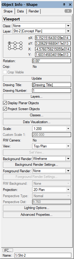
Hi, when I create a new viewport on a new sheet layer there is nothing visible. Checked all settings, layers classes scale and seem OK. The only thing I notice is object info shows a small range of x,y values (approx.+x 9, +y3, x-4, y1). This is on a plan printing at 1:200 on A1 paper. I don't believe I've cropped selection...I can't zoom in to show anything on sheet layer. I'm thinking there must be a setting I'm missing...Any ideas please?
-
 Hi, I have just reinstalled VW2016 Landmark on Windows 10/64 after a disk failure. At the end of the installation a GUI popped up prompting me to install tree, plant and surface models. It didn't work first time when I selected install all and when I clicked on the icon in the taskbar it disappeared and I can't see where to open it again Can anyone tell me please, How do I get it back to install the models I need? Thanks