


Vlado
-
Posts
657 -
Joined
-
Last visited
Content Type
Profiles
Forums
Events
Articles
Marionette
Store
Everything posted by Vlado
-
@trashcan Vectorworks 2021 should be able to import SketchUp 2020 files. It sounds like a problem, do you think you can send me a test file that fails, so we can see what's going on? (send to vstanev@vectorworks.net)
-

2020 Teaser Tuesday - GIS Improvements - Vectorworks 2020
Vlado replied to JuanP's topic in News You Need
Hi @dutch Rene, as I said it's at the top of our list, but it's too early to commit at this point. Check back later, more towards September. -
Irrigation Catalog Additions, and Perf Prec Rates
Vlado replied to Luke Gilmer's topic in Site Design
Hi @Luke Gilmer can you please take a look at the catalog files (see my previous post) and check for errors there, as there are two things: display units are specified by the irrigation settings and that's where the error is, or the catalog contains errors. Please file a bug in Jira about any bugs you see in the feature or in the catalog, providing a test file to demonstrate the problem. If you don't know what Jira is, or you cannot access it, please send me an email explaining the problem with a test file at vstanev@vectorworks.net Regards, Vlado -
Irrigation Catalog Additions, and Perf Prec Rates
Vlado replied to Luke Gilmer's topic in Site Design
Hi @Piotr Karczewski and @Luke Gilmer, Yes, it is awkward to add content from the feature UI, but there is an easy way to do it via Excel. Go to the 'Libraries\Defaults\Irrigation\Catalogs' location in your Vectorworks installation. There you'll see a list of files organized by name which relates to the tool and mode, they are named well so you'll orient easily what is for what. Then notice that there are three files with the same name, and then another three with the same name suffixed with ' - Performance Data' The idea is that the first triplet will list the available products, and the 'performance data' file will specify the performance of each product listed in the other file. The triplet files are with extensions: xml, xlsx, and txt: - The XML file defines the meaning of the columns in the xlsx (Excel) file, listing the type/unit of the value in this column. Please do not edit the XML file, but you can use it as a reference to understand the data. - The XLSX file is an Excel file with the data. For example the 'Outlet Rotors.xlsx' will list rotors. Note how not all the cells on column A and B has value. This is because there is implied rule that if a cell is empty, the value of the last non empty cell up on this column will be used. This makes for easier reading of the tables. - The TXT file is an export from the XLSX file. Have the XLSX file open in excel, then go to 'Save As' and choose type 'Unicode Text (*.txt)' before saving. So, the process for adding content is that you edit the XLSX catalog file (e.g. Outlet Rotors.xlsx), add the products you need then edit the corresponding 'Performace Data' XLSX file (e.g. Outlet Rotors - Performance Data) providing performance information for the products you just added. Then export both XLSX files to unicode TXT and override the ones from Vectorworks. Then you'll see your data show up in Vectorworks. I'm not sure at the moment, but you might experiment to put the TXT files in your user folder, and Vectorworks might pick them up instead of the ones from the application content. Note! When editing the 'Performance Data' XLSX file. The Column B is 'Model (criteria)' This means that you can use '*' (any sequence of symbols) and '?' (any one symbol) to specify several models that share the same performance data. This is for convenience and makes the data more compact. (see attached image)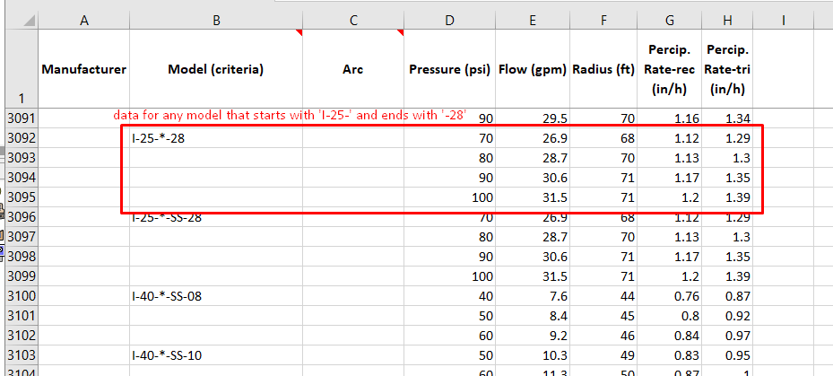
-
2020 Teaser Tuesday - GIS Improvements - Vectorworks 2020
Vlado replied to JuanP's topic in News You Need
@Mark Aceto well, i'm not really familiar with this server. I guess you can open the URL in a browser: https://cache.gis.lacounty.gov/cache/rest/services and look through it to see which one you will be interested. Vectorworks will be able to work with any service that is (MapServer). you can use the 'ArcGIS JavaScript' link in the browser when you open a service to look at it. Like for example this one: https://cache.gis.lacounty.gov/cache/rest/services/LACounty_Cache/LACounty_Aerial_2006/MapServer When you click on 'ArcGIS JavaScript' you will see the imagery that this service provides. Vectorworks will be able to show this image too. And if this image is blank, it will be blank in Vectorworks too. -
Plug-In Object Control Pts, OIP and Text Handling Qs
Vlado replied to AlHanson's topic in Python Scripting
Hi @_c_, please please go ahead. Also, please feel free to modify the https://developer.vectorworks.net/, it's a wiki for that reason, to allow invested users to contribute with their knowledge. Regards, Vlado -
Lock the handle and it will show up as read only. SDK: gSDK->LockObject, there doesn't seem to be a Script function to lock objects
-
2020 Teaser Tuesday - GIS Improvements - Vectorworks 2020
Vlado replied to JuanP's topic in News You Need
Hey @Mark Aceto the URL at which you can access the data is: https://cache.gis.lacounty.gov/ I used chrome dev tools to see where they make request to at this site. It would depend on what you need, when you choose a service from there. I tried the 'Census_2020/CensusBlocks_City' and it showed something. You can browse the services, and view them in a browser by appending to this url, so it looks like this: https://cache.gis.lacounty.gov/cache/rest/services Then you can browser around and see what you need. You can use the JavaViewer for quick look at the services. What you see there, would be available in Vectorworks too. -
That is a special index to an internal list created with the build function, and only accessible with the appropriate functions. @Lada can you help with this question?
-
Is there any possibility to update VW 2020 python version?
Vlado replied to relume's topic in Python Scripting
I'm not sure exactly, but you should be able to send 'system' commands, and run scripts using the system. I'm still not fully researched this, but it was related to the SSL:CERTIFICATE_VERIFY_FAILED error. Essentially, you need to install a symlink to the system's certificates into the SLL of the Python you are using (Vectorworks') I don't know exactly yet, but I have this URL saved for further investigation: https://stackoverflow.com/questions/35569042/ssl-certificate-verify-failed-with-python3 and this code snippet: import os import certifi import ssl openssl_dir, openssl_cafile = os.path.split(ssl.get_default_verify_paths().openssl_cafile) os.chdir(openssl_dir) relpath_to_certifi_cafile = os.path.relpath(certifi.where()) print("delete: "+openssl_cafile) print("sym link") print(" src="+relpath_to_certifi_cafile) print(" dst="+openssl_cafile) and this code for testing, where it was failing due to the error mentioned above: import urllib.request requestURL = urllib.request.Request( "https://www.vectorworks.net/cached/themes/vectorworks_redesign_2018/assets/images/logos/vw-logo-full.svg", headers={'User-Agent' : "Magic Browser"} ) response = urllib.request.urlopen( requestURL ) -
Is there any possibility to update VW 2020 python version?
Vlado replied to relume's topic in Python Scripting
Hi @JoeBayLD, Unfortunately, Vectorworks 2020 python cannot be updated as it is a major change with lot of risk. is this a SSL:CERTIFICATE_VERIFY_FAILED ? if so, then there is a way to create shortcuts in the python of vectorworks to add access to certificates. -
2020 Teaser Tuesday - GIS Improvements - Vectorworks 2020
Vlado replied to JuanP's topic in News You Need
Hi @Carol - Design Express This is next on our lists to do. Regards, Vlado -
@MSLD Well, we always see to convert over when we change things. So please, don't hesitate to use it at its full capabilities. You can get really nice results. As for help, click F1 on the Define Tag Field dialog, it leads here: https://app-help.vectorworks.net/2021/eng/index.htm#t=VW2021_Guide%2FAnnotation%2FCreating_data_tag_styles.htm%23CSH_41 The collapsed parameters on #8 is talking about the field definition syntax.
-
@MSLD the formula you should use for this is: "Too Large"@#AREA#>100sq m:"Too small" As @TDimov said, the data tag condition expression is: <Value_If_True>@<The_Condition>:<Value_If_False> Note, you have to be careful with the spaces around the condition, it does not expect any spaces. It is known problem that the Data Tag uses its own syntax for the formulas. It's at the top of our list to make it use Worksheet formulas in the future.
-
Landmark Drip outlet modification CRASH CRASH CRASH
Vlado replied to Luciole Design's question in Troubleshooting
FYI, the. Vectorworks plugins are not signed. The problem is that when you download a zip on the new Mac OS, it automatically get quarantined, so nothing you unzip from it would work, unless you de-quarantene the zip itself on your side before unzipping. Of course, waiting for SP2 would work, and it will be (is already) fixed there. -
Landmark Drip outlet modification CRASH CRASH CRASH
Vlado replied to Luciole Design's question in Troubleshooting
Yeah, you have to de-quarantine the zip file, before unzipping. Use the terminal to do that: xattr -d com.apple.quarantine /Users/vstanev/Downloads/LandscapeIrrigation.vwlibrary.zip xattr -d com.apple.quarantine /Users/vstanev/Downloads/LandscapeIrrigation.vwlibrary.zip Change the path to the zip as you have it on disk. Also, pease make a duplicate of the original file before overriding. I'm not sure what do you mean in 'no hope in switching'? Can you clarify? It is OS independent bug, and i'm trying to help you by sending the file directly as I was under the impression you are on the mac. -
Landmark Drip outlet modification CRASH CRASH CRASH
Vlado replied to Luciole Design's question in Troubleshooting
@Luciole Design we found it and it's a bug. It will be fixed for SP2. if there is anyone else struggling with this, please let me know. -
Landmark Drip outlet modification CRASH CRASH CRASH
Vlado replied to Luciole Design's question in Troubleshooting
Hi @Luciole Design, is it possible to send me the crash log? That's the text when you click on the 'report' button after you get the crash. You can just dump paste it in a text file and send it over: vstanev@vectorworks.net Thank you. -
2020 Teaser Tuesday - GIS Improvements - Vectorworks 2020
Vlado replied to JuanP's topic in News You Need
Hi @jeff prince, Please report each case where you see crashes and/or problem, we're actively trying to make the software more stable and reports like this are valuable. I'm sorry to hear that, and I understand your pain. I can assure that we're striving to improve the software, and you can imagine there are many ways it can be improved. There are many people with many wishes about many areas of Vectorworks, and they are all important. We are doing our best to log and generalize the wishes and then to prioritize them all in order for the engineering to focus on. So, please don't give up. We do appreciate user input, especially if it a well thought out and described workflow that needs to be added or improved. This helps us understand, prioritize, and eventually implement it. Regards, Vlado -
2020 Teaser Tuesday - GIS Improvements - Vectorworks 2020
Vlado replied to JuanP's topic in News You Need
Hi @jeff prince, Thank you for your comments. This feature is dedicated to access various data from ESRI, not just maps, but for that you need to login into their Services. Depending on the region, they might have more detailed satelite images. Can you please elaborate on this? We're looking for ways to improve this. You can send me workflow videos or screen capture directly at vstanev@vectorworks.net Regards, Vlado -
2020 Teaser Tuesday - GIS Improvements - Vectorworks 2020
Vlado replied to JuanP's topic in News You Need
Hi @Ben Beaumont, can you define the request? What file format is this? I guess it contains geographical information, and the goal is to place it properly, right? -
Yes, Vectorworks 2021 uses Python version: 3.8.2
-
Hi @Aspect_Design, unfortunately, this is not possible at the moment. Please enter it as a Jira bug so we can make it work. The Properly Line has the 'Segment Record' format record attached to object inside, which allows you to report the segments in a worksheet. Also, there is a 'Curved Segment Record' one too. Regards, Vlado
-
@P Retondoi'll add this information to an enhancement request, so it is considered for the future improvements in the area. Thank you very much, examples and workflow definitions always help
-
Hi @samgbickel, there is an option to disable the automated calculations, but unfortunately there is no UI for it. To disable it, find the file 'IrrigationSettings.xml' located in "<app>\Libraries\Defaults\Irrigation". You can edit it there, or better copy it in your user folder, in the same location: '<user_folder>\Libraries\Defaults\Irrigation' and edit it there. The difference is that if the change is in the user folder, any SP that you install will have this option, otherwise it would be just for the version you modify. In that XML file, find the tag <AutoCalculation> and change it to 'false'. This will disable the automated calculations. Regards, Vlado
- 8 replies
-
- 1
-

-
- irrigation
- landmark
- (and 2 more)
