loic.jourdan
-
Posts
20 -
Joined
-
Last visited
Content Type
Profiles
Forums
Events
Articles
Marionette
Store
Everything posted by loic.jourdan
-
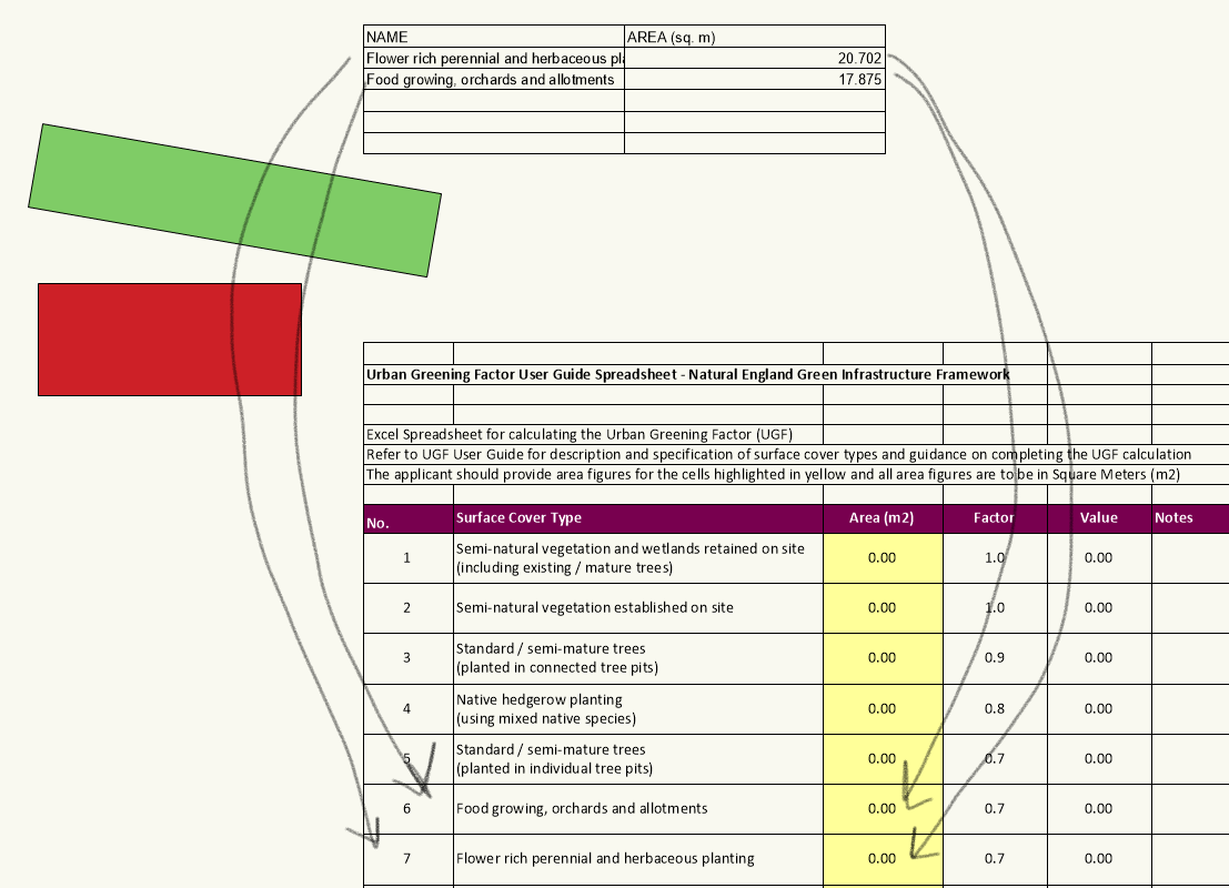
Hi all, I have two separate worksheets and would like to be able to transfer the data from one to the other without having to manually copy and paste it. Worksheet 1 is a simple worksheet with 2 columns. Column 1 = Class Name Column 2 = Sum of Areas (of all objects within each class) Worksheet 2 is a worksheet imported from the Natural England website and is the standard Urban Greening Factor calculator, it works by the user populating the area column with the data from their proposed design and then, using a the factor for each different object type, it gives a final score for the overall project. I would like to be able to transfer the data from WS 1, into WS 2 so I can run a script and automatically get my calculation. The class names in WS 1 are identical to the Surface Cover Type in WS 2 so really I would just need a method of automatically recognising the names, matching them up and then transferring the numerical data from column B into the relevant fields. If it is easier to do, I am happy to lose WS 1 and have all the areas input directly into the calculator, I just have no idea how to do that and thought breaking up the worksheets may make it slightly easier. I have tried writing a script myself to solve the issue but keep running into the issue of my script not being able to locate my worksheets, either in my drawing or in my resource manager so haven't been able to get very far with it at all. I have attached an image below to hopefully give some more context, here is the link to download the UGF calculator spreadsheet if that is something that would be helpful: https://designatedsites.naturalengland.org.uk/GreenInfrastructure/downloads/UGF User Guide Spreadsheet.ods

-
Perfect! Thanks @Pat Stanford that is so helpful, thanks also to @michaelk for your contributions to this script, I will likely be using both at different points in the future 🙂
-
Removing Suffix from Shapefile Export
loic.jourdan replied to loic.jourdan's question in Wishlist - Feature and Content Requests
@John S. Hansen Unfortunately I'm on PC, but I will have a little look and see if I can find something similar! Thanks for the suggestion 🙂 @zoomer Exactly, I don't think I should have to find a solution for a problem that doesn't really need to be there! Hopefully VW will sort this out at some point down the line... -
Hi Pat, I have attached a blank file below with my worksheet in it. The excel file was provided to me by one of our ecologists and I have imported it into VW as a worksheet. For context, column A is a code (ecoha1, ecoha2... = Ecological Habitat Area 1 / ecol1, ecohl2... = Ecological Habitat Line 1) and column B is that codes actual name. The reason we have to use these codes is due to our GIS software (which was developed internally) isn't very good at recognising long class/layer names, using this coding system allows us to avoid any importing issues when taking our file from VW to our GIS software. I would like to create a class for each code with the actual name as the tag so it shows in my class drop down menu to avoid confusion later. Hope that makes sense! BNG Class Naming File.vwx
-
Thanks @michaelk and @Pat Stanford for you speedy replies! Pat, I've given the script you wrote a go and it works perfectly for renaming the class tags to a specific string (My classes now all have the "My New Tag" tag attached), but is it possible to then, using what Michael has suggested, to use data from my worksheet to set that tag? I tried to use Michaels advice of setting up a column with my desired tags, each with a semicolon at the end and then adding it into your script so that it can take my tags and apply them instead of the default one you created but I'm not having any luck with it, I will try again in the morning but is there any easy way of adding the ability to take data from my worksheet into your script? I will try again in the morning, but I think I'm a little out of my depth! Thanks again for your help so far!
-
This has been really helpful so far - is it possible to, instead of editing the description, edit the tags so it shows in my class organisation pop up window. I've tried to edit the script myself but can't find the VS page to tell me the function name (I tried using "BResult := SetTagsText(ClassHandle, ClassTagsinWorksheet);" but had no luck).
-
Removing Suffix from Shapefile Export
loic.jourdan posted a question in Wishlist - Feature and Content Requests
When exporting a shapefile from VW it adds the suffix _polygons or _polylines to each exported file, I then have to rename each file from the export to remove the suffix as it disrupts the shape files import into our GIS system. The suffix is completely unnecessary for us so an option to toggle it off would be preferential as we will never need it to be included in our file name. As far as I am aware there is no option to remove this suffix, I have looked through the VW preferences and the shapefile export preferences but can't find anything. There is an old Wishlist post from 2014, asking for its removal, that never got a response (attached below) so I'm hoping this will be looked into this time. As the previous post suggested, a simple tick box with the ability to disable the suffix would be more than sufficient to fix the problem. Thanks. -
Hi All, I am trying to find a way of joining up hedges in T junctions and cannot seem to find a way. Previously I was drawing out my polygons then creating the hedge line by using the plant line tool but in the interest of using the tools VW has to offer I am trying to replace this workaround with the hedge tool. I find that if the hedge line is just one line this is fine, but if I need the hedges to meet at any point other than the ends (for instance, when using the hedges to separate gardens in a large residential development), there is no way of connecting up the lines and I am left with a multitude of scruffy looking "junctions". I have tried to draw a T shaped polygon and then convert it into a shape but VW just draws the hedge around it and you are left with a hedge that is double the width you need it to be or draws the hedge as a a hollow shape leaving a large gap between parallel lines. I'm just wondering if there is a way of connecting lines in a T junction and then converting them to hedges? This would really help out with my workflow so any help on the toopic would be appreciated
-
Create multiple symbols at once using the select similar tool?
loic.jourdan replied to MFpsrig's topic in Workflows
Thanks Tom, I was having a similar issue and had no idea about this workflow, that's super helpful. -
Multi-discipline Collaboration with Revit BIM Model and Vectorworks.
loic.jourdan replied to dcg's topic in Workflows
Hi Dermot, Ah we mostly likely have met at some point then! I've not really found anything on the university to be massively helpful in terms of BIM, they seem to work a lot on idealistic scenarios which I find is very rarely, if ever, the case when working on a live project. I did find one video on there that spoke briefly about BIM workflows for landscape that may help, if you go into the landscape tab and type BIM into the search bar you should find it ("SWITCHING YOUR FIRM TO A BIM WORKFLOW & MINDSET"). If you have layers, classes, materials and hardscapes all set up I'd say you're doing a good job already! Just be aware with some BIM projects that they may ask you to use a uniclass system - This is a bit of pain for landscape as it has clearly been developed for architect/MEP with landscape as a second thought but its a good idea to be at least aware of it just in case it becomes a requirement. For myself, the hardest part about the BIM process was working in 3D as we had previously only worked in 2D, but if you can get to grips with the modelling you should be fine! Things like adding IFC data is relatively easy to do once you have the materials/model ready. As far as exporting reports to go with the model goes, we have no really been asked for this before, so long as you can provide a 3D model with data attached and 2D drawings from that model, you should be fairly comfortable. That's just my current (limited) experience, but if you do need to provide reports it is relatively easy to set these up to be done automatically from your model. Just make sure you are given a BEP (BIM Execution Plan) and ensure it has the coordinates you need to set up your file (using the link to the community post I sent in my first response). This has been the main stumbling block for us, if you can, get one of the architects to send you their model through to reference into your file so you can check everything links up and your building is correctly located. It sounds like you're well prepared for it, if I can think of anything else that's been super helpful for me I will let you know, currently its just been a bit of trial and error process for us (and definitely still is). Just do your best to give yourself plenty of time to work on it. Good luck! -
Multi-discipline Collaboration with Revit BIM Model and Vectorworks.
loic.jourdan replied to dcg's topic in Workflows
Hi, I'm the technician in a landscape department, based in the UK, and have had to collaborate with Revit on a couple of BIM projects now. I would suggest having a look at this post from Jack, I found it super helpful for setting up projects that will then be sent to BIM coordinators/architects: My personal experience has not exactly been plain sailing and we have had push back on our use of VW, but it is possible to work between the different platforms. I find it's important to remember (and occasionally remind others) that it is the BIM workflow, not the Revit workflow. VW exports to IFC without issue and we have had positive feedback from architects on projects when using VW. If there is anything else I can do to help out just send me a message, I've had plenty of issues with it in the past, the post I have linked from Jack was a real help and eliminated lots of the problems I was encountering. -
Assigning Individual Data Tags to Multiple Objects
loic.jourdan replied to loic.jourdan's topic in Data Tags
UPDATE: I did some digging into this issue over the Christmas period and have solved the problem I was having, I believe it was an issue with my data tag (I'm very new to both data tags and record formats) and not a VW bug, I started from scratch and on the second run everything worked as it should. I can now select all relevant objects using a script, assign a record to each selection and batch fill all standardised field, then add a data tag to each objects which links into that record giving each object a unique ID code that can be exported as part of the shapefile that is then imported into our external software. A few interesting things to note: I don't particularly want the unique ID to show on each object when I export it + don't want to confuse an external software with a complex object like the data tag, I found that if you delete the tag (can all be selected using the magic wand), the data in the record will remain. Also, if you have to re-run the process of assigning a unique ID (if there has been an update to the drawing) it will override the existing data in the record and renumber all objects.- 1 reply
-
- 1
-

-
I am experimenting with using data tags to apply codes to polygons/polylines, I have them set to increase incrementally so each object has a unique code. It works great, and feeds back into my record format which in turn is exported to an external software via shape files. However, I have to do this for dozens, hundreds and sometimes thousands of objects so would prefer for this process to be able to be slightly more automated. I have been trying to figure out how to assign a data tag to multiple objects but cannot get my data tags to apply to all selected objects. When I have my data tag tool active with my data tag style as the option I can only use the single eligible import option, I would like to be able to use the selected eligible objects mode so that I can select all relevant objects and then assign them a unique code through the data tag. Just want to know if it is possible to select multiple objects that are not symbols or VW native building objects like windows and doors, and assign a data tag to all of them?
-
Hi @Pat Stanford, This has been super helpful to me, thank you so much for providing it! I have managed to edit the script (using your advice) to include all the different object types I would need. is there a way to click on one object, assign it a number in the pop up box and then every other object/polygon takes its number from there? This would save me from having to click on each object. I have tried to see if there is a way to select all objects and then run the script but it still requires me to go through and click each one individually. I am wondering if there is a way of me selecting all objects, running the script, assigning the first ID number, and then for the script to automatically "click" through each selected object. Hopefully this makes sense, I'm useless with scripting so any help would be appreciated!
-
Aligning Vectorworks and Revit Models for BIM (for (almost) beginners)
loic.jourdan replied to Jack2022's topic in Workflows
Hi Jack, Just wanted to say thanks for taking the time to write this out, your instructions were super clear and very easy to follow. Have you had any feedback from architects, BIM co-ordinators or other disciplines from using this process? No feedback is probably good news anyway but just wanted to see if you'd had anyone comment on whether or not this works as well as Revit files referencing into each other? I've had a few issues now with Revit users commenting on VW files not automatically taking the coordinates/project north from their model and that they have had to manually move them to fit. I will be using your process on my next big project to see if it rectifies the issues I've been experiencing! -
Export to DWG...Hardscapes export as Blocks? Why?
loic.jourdan replied to ericjhberg's question in Wishlist - Feature and Content Requests
Hi All, Just responding to this to find out if the issue has been address since the question was first asked. I am using VW 2023 (SP6) and am experiencing the same issue when exporting to CAD, was a fix ever implemented or has a work around been found? -
How do we edit the new Path Modifier?
loic.jourdan replied to hollister design Studio's topic in Site Design
Anyone know if this issue has been fixed yet? I'm having the same problem with the pathway site modifier tool, although there is a reshape tool within the profile editor I cannot actually move it to where I want it to be, only in the Z axis. -
Get fill color of a class on a worksheet?
loic.jourdan replied to grant_PD's topic in General Discussion
@Pat Stanford This is great, thank you so much for doing that so fast! Works perfectly 🙂 -
Get fill color of a class on a worksheet?
loic.jourdan replied to grant_PD's topic in General Discussion
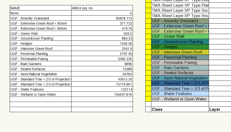
@Pat Stanford Thanks for your fast reply, having UGF as the prefix for the class would be perfect as the only classes I need to be highlighted all have the prefix UGF (as you spotted). Essentially, I'm just trying to combine the two tables into one and the colours are just there to help my colleague, who I will be exporting the worksheets to as an excel file, to associate the colours with a key she uses more easily than having to use the names. -
Get fill color of a class on a worksheet?
loic.jourdan replied to grant_PD's topic in General Discussion
Hi, This script works perfectly, thanks for all your work with it. I was wondering, is there a way to modify it slightly so that it only displays specific classes? I can get the class names I need from a worksheet/database by setting a layer for the data to come from, but I would really like to be able to add the colours into that worksheet if possible. If anyone could help with this, it would be much appreciated!