


Steve White
-
Posts
5 -
Joined
-
Last visited
-
Model unexpectedly clipping / disappearing.
Steve White replied to Steve White's question in Troubleshooting
Peter, just followed your video when setting up a new drawing, helps a lot, thanks -
Model unexpectedly clipping / disappearing.
Steve White replied to Steve White's question in Troubleshooting
It is far away from the origin because it's drawn to OSBM - standard procedure in the UK. I've been working on it for a couple of days and it started doing this a couple of hours ago. There are no files referenced. Can an alternative temp origin be set up? similar to alternative UCS in Acad or ACS coordinate point in microstation? -
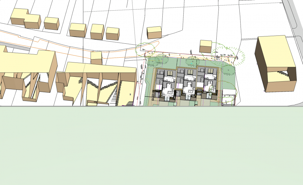
Hello All. The model I am working on has suddenly started to 'clip'. As though clip cube is present except it is not turned on. The model is effectively unusable in this condition. I am unable to zoom in any closer than shown as it disappears. Has any one experienced this? Have I unknowingly clicked a setting? The image attached shows the model clipped through the ground plane and adjacent buildings at an oblique angle. Any thoughts would be much appreciated. Steve.
-
referenced layers spontaneously move origin
Steve White replied to JoshW's topic in General Discussion
I'm having the problems described here, viewports moving / disappearing and the reference resetting to origin after being moved, when it is updated. We have the building model on it's own grid coordinate system. Site has it's own datum, when we overlay the reference we can't move it, when we set up a design layer view port we can move that but it either then disappears or relocates. Our site model is currently unusable. Anyone find any work arounds or solutions? Steve. -
Hello, New user here, though have worked through a lot of tutorials and tuition. We have a site plan derived from a survey. The plan and the survey can not move as they have been set up to project datums and survey coordinates (UK OSBM). We are trying to reference in the ground floor of our building into the site plan. The building is drawn to it's own coordinate system (simply put the bottom left corner is 0,0). When we reference in the building to the site plan and move it to the correct location on the plan - if the reference is updated, the building returns to 0,0 (its coordinate point) in the site plan. We have the 'ignore source origin' box ticked in the reference edit options, but that doesn't seem to work and it keeps returning to the it's own position. This one has us stumped. Any help or thoughts would be greatly appreciated?

