Malcolm Woodruff
-
Posts
32 -
Joined
-
Last visited
-
Is it possible to control terrain models by imposing breaklines? There was a thread back in 2012 which mentions Panzercad but the link no longer works.
-
Placing areas on a drawing
Malcolm Woodruff replied to Malcolm Woodruff's topic in General Discussion
Thanks Pat and Tom. Understood. -
Placing areas on a drawing
Malcolm Woodruff replied to Malcolm Woodruff's topic in General Discussion
Tom, Thank you very much for a clear instruction which worked well. Pat I still think it should be possible to choose what Engineering Properties are placed on the drawing, without having to invent your own Data tags. -
Placing areas on a drawing
Malcolm Woodruff replied to Malcolm Woodruff's topic in General Discussion
Here a screenshot of what I get. I have tried adding AREA where the Q is but no luck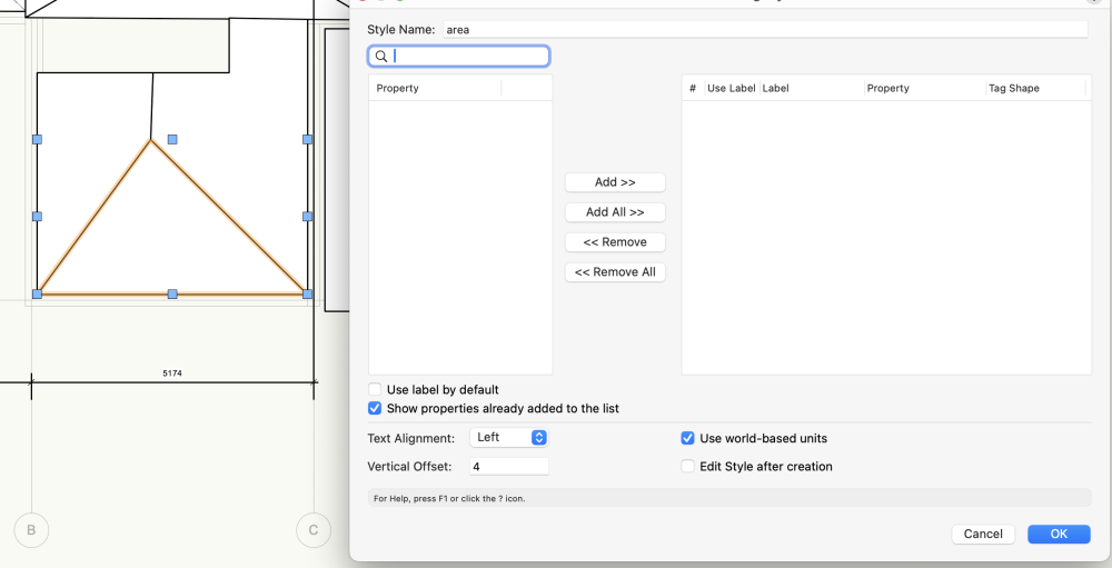
-
Placing areas on a drawing
Malcolm Woodruff replied to Malcolm Woodruff's topic in General Discussion
Thank you but I have tried creating a data Tag but there are no properties listed for a simple polygon. Am I doing something wrong? -
I can place engineering properties of a polygon on a drawing but I just want to place the areas on a drawing with a large number of polygons. This is so basic I must be missing how it is done. Help please! Ideally of course I should be able to choose any of the the engineering properties but I cannot see how to do this.
-
Delete outside a marquee
Malcolm Woodruff posted a question in Wishlist - Feature and Content Requests
I sometimes, inadvertently, send an item a very long way outside my area of work. It then becomes difficult to find it and delete it. What I would like to have is a tool that would delete everything outside of a marquee. -
It would make site modelling much easier if it were possible to create sections along a path. Highroad by Creative Engineering used to do this .by drawing a typical section as a series of links offset from a control line. The links could be slopes, kerbs, retaining walls etc. but would always end in a batter that would attach itself to the ground at the specified slope. It was also possible to have a split point at the end of a link with alternative sections, one with an upward batter at the end and the other with a downward batter.. That way you would automatically get different sections depending if it were cut or fill. You would specify the sections at a particular chainage along the control line and interpolation would take place between them. This made the design of earthworks or roads very simple and extremely fast. By running the control line around the sides a pad different slopes could specified for these as well. I have not seen a better system. Could we have something similar in VW please?
-
I often want to show a basement construction where the excavation is done in stages, or part of the basement is at a deeper level. Putting a site modifier on top of an existing site modifier does not work. It would be good if you could use a site modifier for the first stage and then use the modified model as the DTM before placing th net site modifier for the second stage etc. Is this possible? If so, how?
-
Thank you for this. I have been going mad trying to fit a specific slope around a pad because I could not imagine that something so basic could not be done! 30 or so years ago an Australian company, Creative Engineering, came up with a solution for this which I have not seen bettered since. Unfortunately, the firm is no longer around and their product HighRoad is no longer available for current operating systems. The way they tackled the problem was to have a control line, say the edge of a pad, or the centre of a road. The control line was a 3D polyline with a chainage and you could specify a typical section at any point along the control line. For a pad this was done to one side of the control line, for a road, or path, sections could be specified each side of the control line. So that it was a simple manner to create a road with a crown using section lines each side of the control line. Typical sections were drawn with a series of links to form the shape you want and might include kerbs, retaining walls, changes in slope etc. The final link needed to be attached to the ground and this was done by clicking on the final link, which was usually a batter, and specifying that it should continue to the ground. It was possible to have more than one section at a point eg different slopes for cuts and fills. So, the program would follow one set of links but if the ground was not encountered within the grade limits then it would follow the alternative path. The program would then interpolate between specified sections along the control line. I would commend this method of site modification to VW. As a matter of interest the program was a complete road design program that took in the original survey, produced plans, vertical profiles and cross sections, calculated quantities, gave setting out details, had a drive through video of the finished road and all fitted on one floppy disk!!
-
Just an update. I bought a new IPAD Pro and it is running fine. Scans are amazing 🙂 Still not running on the old IPad though.
-
Ground model from Sketchup input
Malcolm Woodruff replied to Malcolm Woodruff's topic in Site Design
Thanks Pat. I am running VW 2024. When creating a terrain model the program complains about duplicate points and vertically duplicated points so I had tried deleting these. Following your post I tried ignoring this message and it worked! Needs a good cleanup and careful choice of parameters but it works and will save a lot of Tim. Thank you. -
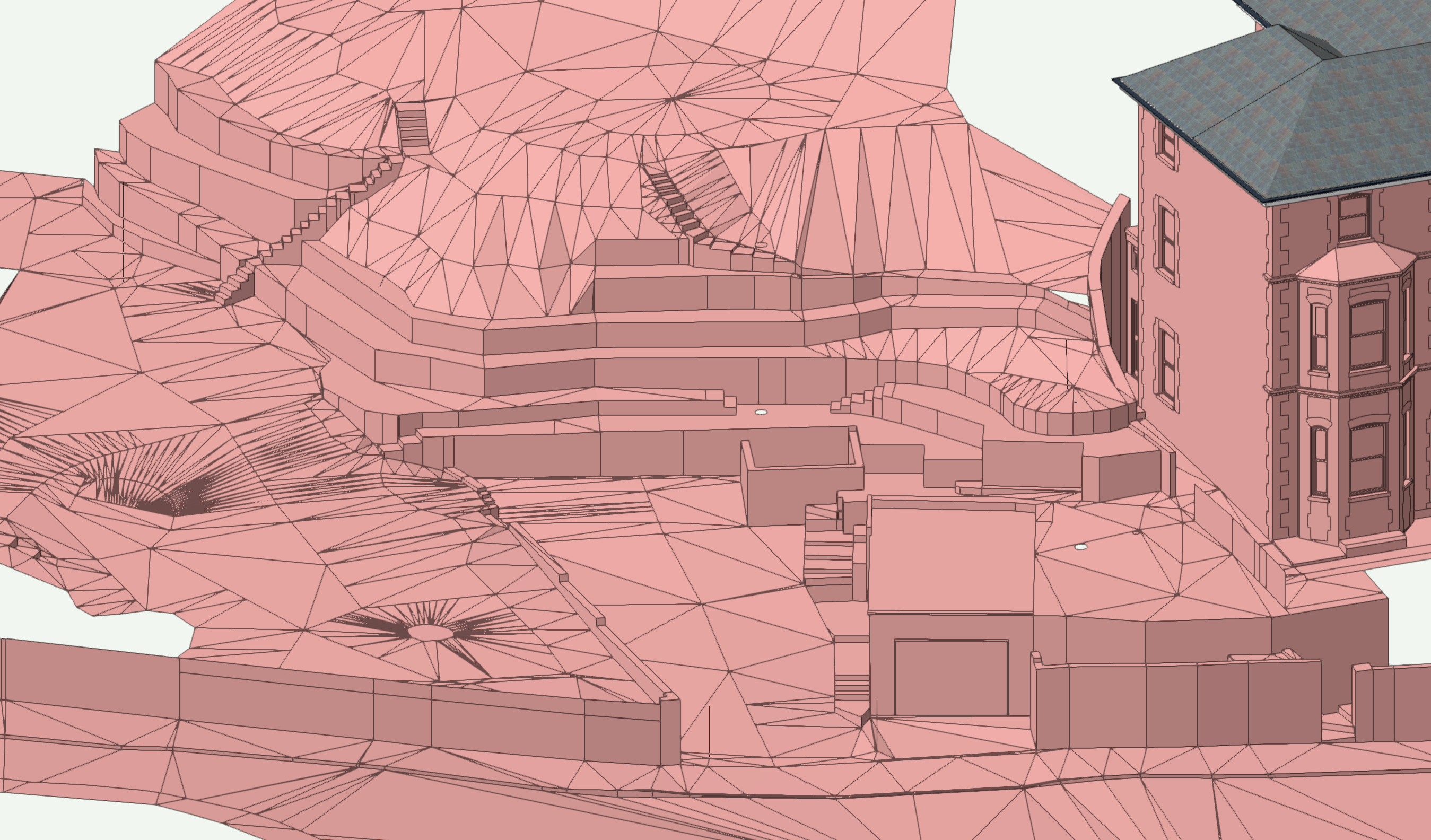
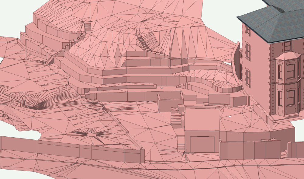
I have a site model done in Sketchup which I have input into VW. I need to create a site model from it so I can start altering it and calculate quantities etc. I would normally do this by changing the vertices of the polygons to 3D loci and then recreating it in VW. However, the model has many vertical walls so the site model in VW does not like it but only gives the option of deleting vertically duplicated points. If I do this it ends up as an inaccurate model. Is there a way of turning the 3D Sketchup or DWG model into a VW site model without losing accuracy? A screenshot of my immediate problem is shown below
-
Well, in that case, it may be just the excuse I need to get a new iPad with Lidar 😃
-
Have tried deleting and reinstalling the ap but no success. The files are there but when I tap on one it just asks me whether I want to share or delete the file. On the phone it asks whether I want to view in AR or 3D. If I continue to press on the phone I get the same dialogue as the iPad so it may be a tapping problem but I have not been able to solve it.