Anders Blomberg
-
Posts
196 -
Joined
-
Last visited
Content Type
Profiles
Forums
Events
Articles
Marionette
Store
Everything posted by Anders Blomberg
-
Cool stuff! This is sure to save me some hours work.
-
@michaelk, or anyone really, could you point me in a direction of how to use scripts, specifically this one? Haven't used such things before.
-
 Posted a response in the referenced thread by mistake so might as well post it here as I intended 🙂 There's also a plug-in, described here.
 -
There's also a plug-in, described here.
-
Creating Partial Plant Schedules - How to Define Criteria?
Anders Blomberg replied to Michal Zarzecki's topic in Site Design
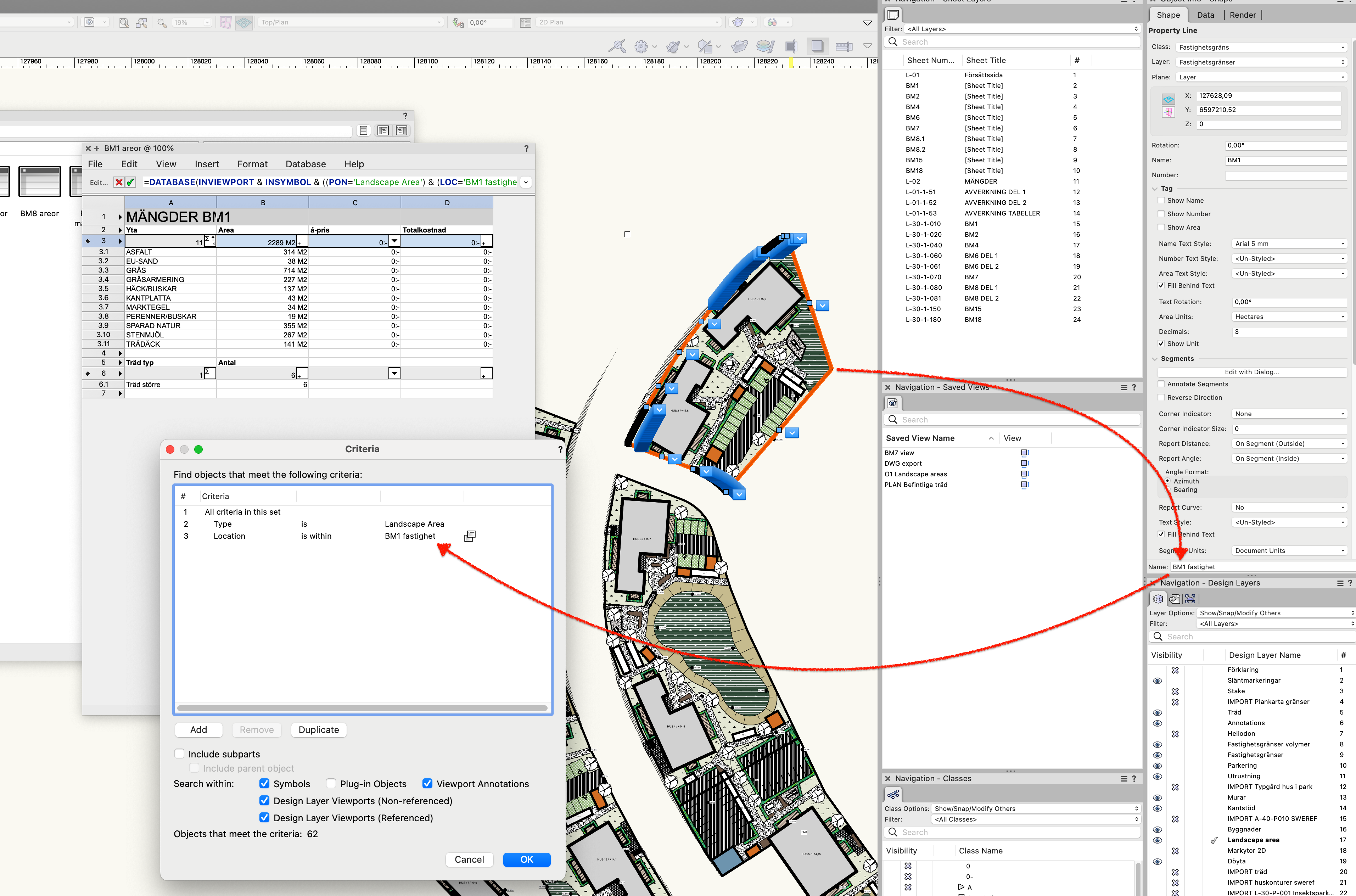
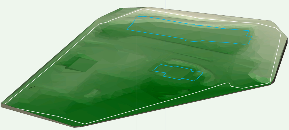
@Michal Zarzecki You could also draw shapes, such as polylines, around the different beds, name them, and then use them as "location" criteria in the worksheets. I recently did this to separate out quantity take-offs per property in a project, see below. Very handy, trick learnt from @JMR here.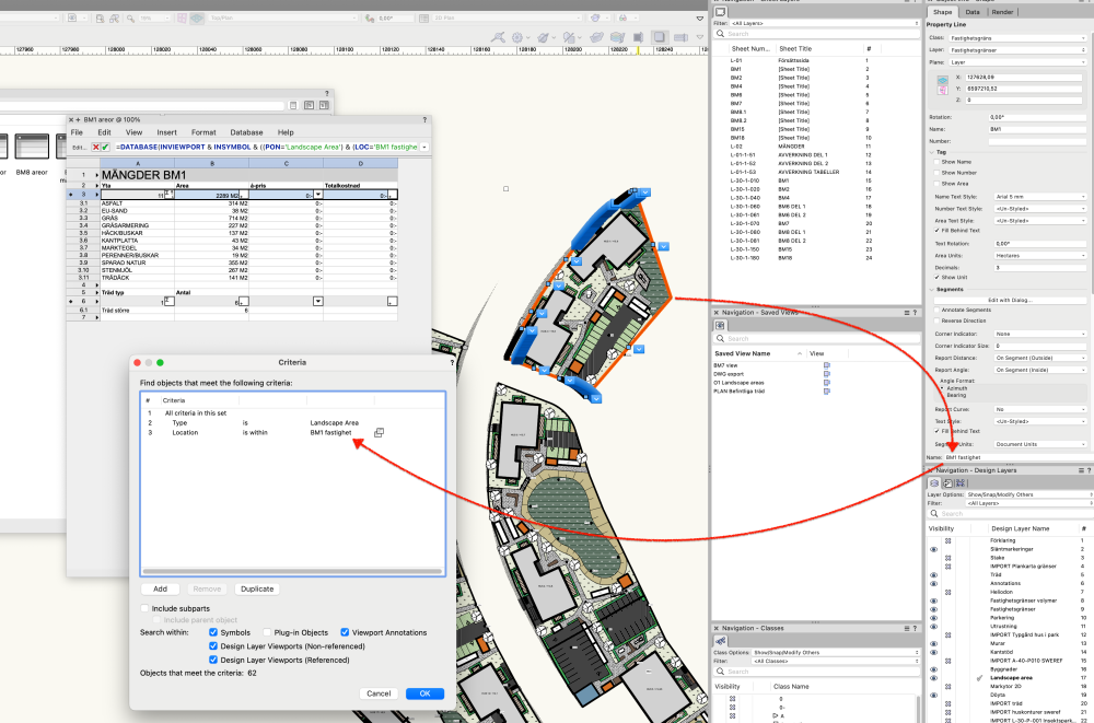
-
Vectorworks abandoning perpetual licences
Anders Blomberg replied to line-weight's topic in General Discussion
Any indication this is coming? -
Vectorworks abandoning perpetual licences
Anders Blomberg replied to line-weight's topic in General Discussion
From previous experience in an Autodesk dominated business, it was difficult enough to try and keep everyone on the same format of Revit with just the yearly releases. In the last 10 years I've seen a change towards people always using the latest version of their software, whereas some people tended to try and update as little as possible before. It created an absolute mess when trying to coordinate larger projects, so personally I'm rather in favour of the trend, but obviously there are many aspects to it. Can't say anything about the developer side of it though. -
Vectorworks abandoning perpetual licences
Anders Blomberg replied to line-weight's topic in General Discussion
@Christiaan I sure hope you're right! But is it possible to completely move away from major cycle releases regardless of licensing model? Looking at Autodesk I believe they still stick to major releases every year, while using a subscription model for licenses. Without having to much knowledge of software development it seems that new features might need to be tied to file/model format. Like a .vwx 2021 model vs. a .vwx 2022 model. Doesn't this mean that major release cycles will still be needed? -
Vectorworks abandoning perpetual licences
Anders Blomberg replied to line-weight's topic in General Discussion
@mjm Sad to say that I recognise all of that. I've been using macs all of my life and it's been a joy for most of the time. Freezing computers has been a thing of the past for me for probably 15 years or more and those spinning beach balls are now more common on the actual beach 🙂 With Vectorworks my whole computer can completely freeze up all of a sudden, haven't seen that for a decade before this. Individual software crashes are common. I realise my my hardware might be a little on the shy side though. On the other hand, I've been able to create some delivarables that just wasn't possible before. Can't live with it, can't live without it, as they say. -
Vectorworks abandoning perpetual licences
Anders Blomberg replied to line-weight's topic in General Discussion
I've been contemplating the VW pricing for some time and might as well air my thoughts in this thread as I'm interested in everybody else's views. I'm on the subscription with service select so this change doesn't really change anything for me, so that's where I come from. Now, my thoughts have been circling the fact the Vectorworks is so cheap compared to other software in the field. AutoCAD/Civil3D/Revit all cost way more, especially in the long run, and might also need some plugins on top of that. The engineers sitting next to me pay license fees somewhere around 20 times more than I do for their software. And can't charge much more for their work. There might be cheaper software out there and I haven't really done extensive research on it but this is my view. So VW might offer lower licensing fees but the drawback is that the software seems to cause me constant headaches with glitches, bugs and weird workarounds. I feel like the price sort of reflect the quality. In the end I've still chosen VW as my main tool as I can't find any better software out there, but I would switch in the blink of an eye if I found a better solution for my work. Price is second to good tools to me, and I understand this is different to many of us. I'm in a fortunate position in some ways. So in the end, I feel like VW might not be very cheap after all, considering it's flaws. On the other hand, if they stepped up their game, sorted out multiple issues and introduced way better landscape/civil tools (although not many might be needed) I would happily pay many times the current license fees and be completely happy about it. Obviously I'm not in a position where I can see the future of the development for VW, and wouldn't make any assumptions from this change in licensing, but my hope would be that if we pay more for the software, we get better software. Keeping my fingers crossed on this one 🙂 -
About getting elevation info. on the grading line
Anders Blomberg replied to lixinpm's topic in Site Design
I guess if you use the grade line to change the site model you could also update the site and put a stake there that returns the elevation of that point. It seems that VW doesn't just triangulate between the elevation points but rather treats the whole line as a modifier so the site should follow that line, at least that's how I understand it. -
About getting elevation info. on the grading line
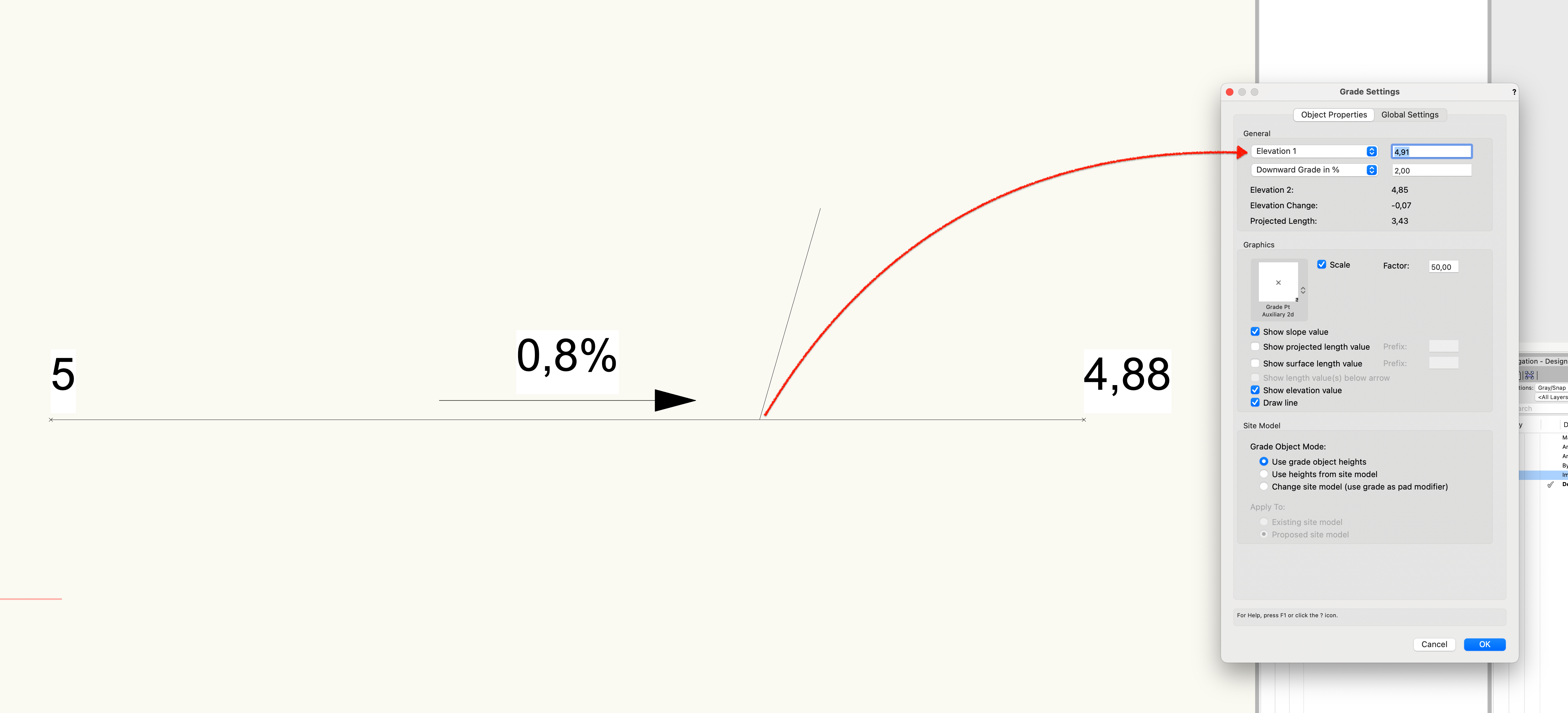
Anders Blomberg replied to lixinpm's topic in Site Design
If you snap a new grade to any point of the "old" grade line it will automatically give you the elevation of that point as elevation 1. If I don't need that secondary grade I just write the elevation down somewhere and undo the action. Someone else might have a smoother solution 🙂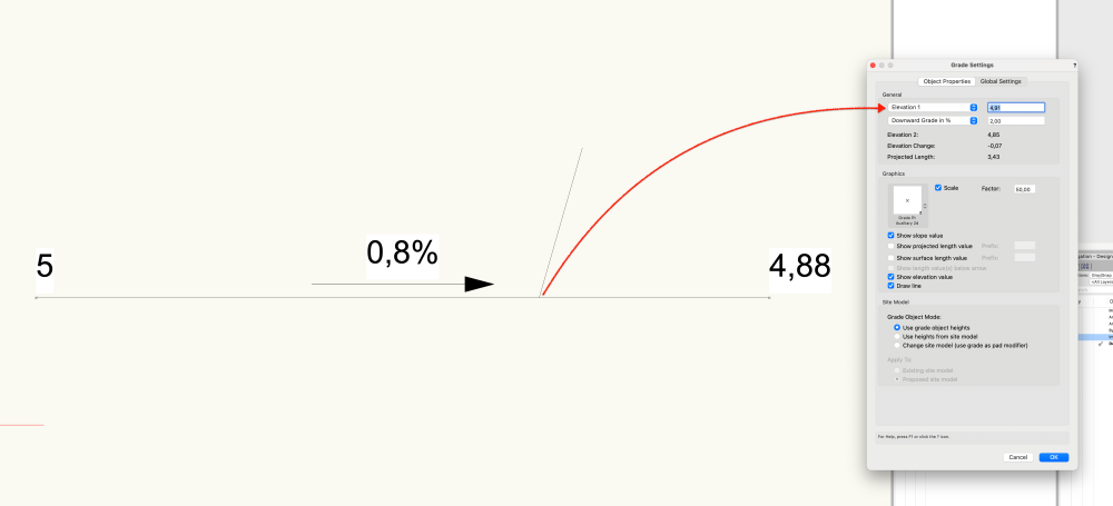
-
Site - Exclude area within grade limits
Anders Blomberg replied to Anders Blomberg's topic in Site Design
For anyone interested I ended up laying out a 1 x 1 m grid of 3D loci over the building footprint and sent those to the existing site surface. Placed the loci in Site-DTM-modifier class and updated the site model. Much better then before but a cumbersome solution and still not perfect.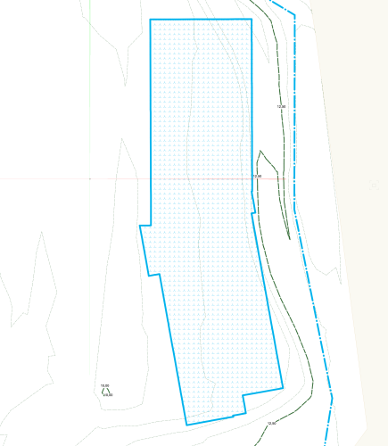
-
For me, the server just won't start. 2022 as well.
-
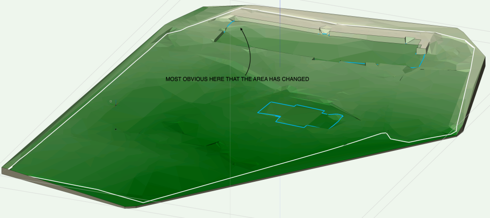
I'm doing a very rough cut and fill calculation and can't seem to remember how to exclude an area within my outer grade limits from being affected by my grades. Specifically I have a school yard where I've done a rough grading with grades and want to calculate the cut/fill excluding the footprint of the new school buildings. I tried 2 things: A new grade limit within the outer limit. Doesn't work, no surprise. Traced the building footprint and sent the lines to the existing site surface. Placed those lines in Site-DTM-Modifer class. This stops the grades from affecting the footprint but the area within the polygon does triangulate within that footprint so it's still affecting the results. Existing site with outer limits in white and building footprints in blue: Proposed grade:
-
Plant array - apply fill across plant grouping
Anders Blomberg replied to Anders Blomberg's topic in Site Design
@Dawnie Changing the spacing value back and forth a couple of times sometimes solves it for me. -
How do you change precision number of z-value
Anders Blomberg replied to Mohammed's topic in Site Design
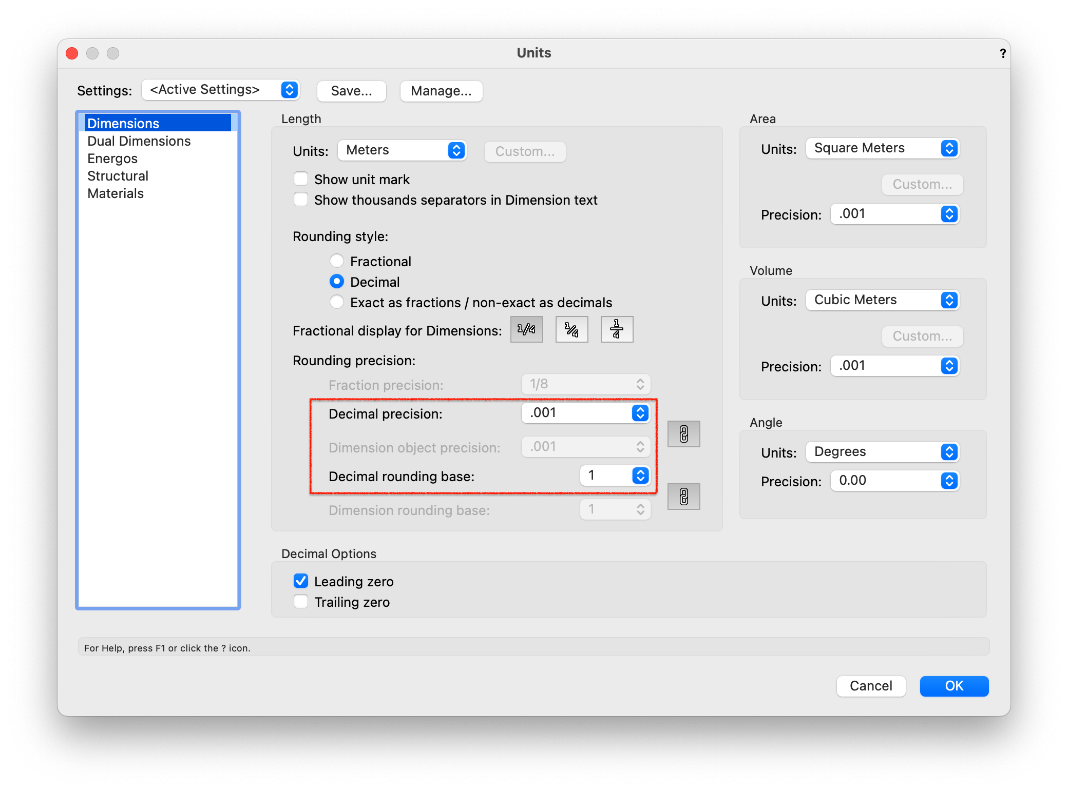
I do believe that if you input 64.732 the modell will update with that exact value. But values in Object info palette asf will only show you precision as set up in the units preferences. Check what's selected under "decimal precision" and "decimal rounding base" under file/document settings/units. Unfortunately I believe this setting also affects the precision of dimensions. Personally I'd like to modell with a precision of .001 m but have dimensions show a precision of 0.01 m. I use the dual dimensions setting to have the dimensions show mm values for certain parts. Someone else might know if this is possible and also verify if I'm correct in my assumptions.
-
Should we use Landscape Areas for 'all' hardscapes?
Anders Blomberg replied to hollister design Studio's topic in Site Design
For me, I've found landscape areas to be the best tool for all areas outdoor. I rarely have completely flat areas outdoors to allow for water runoff and landscape areas combined with geometry adjusting the site in the Site-DTM-modifer class is the best solution I've resorted to so far though. When modelling a graded surface I typically don't want to grade "per surface" but rather have the slopes flow continually over multiple surface types and grading the site and draping it with LA's allows for this. I would love to see/hear more of how others work regarding this though. I try to use styles and classes for everything I do to allow for quick changes of multiple objects whenever possible. One of the benefits of VW as I see it. -
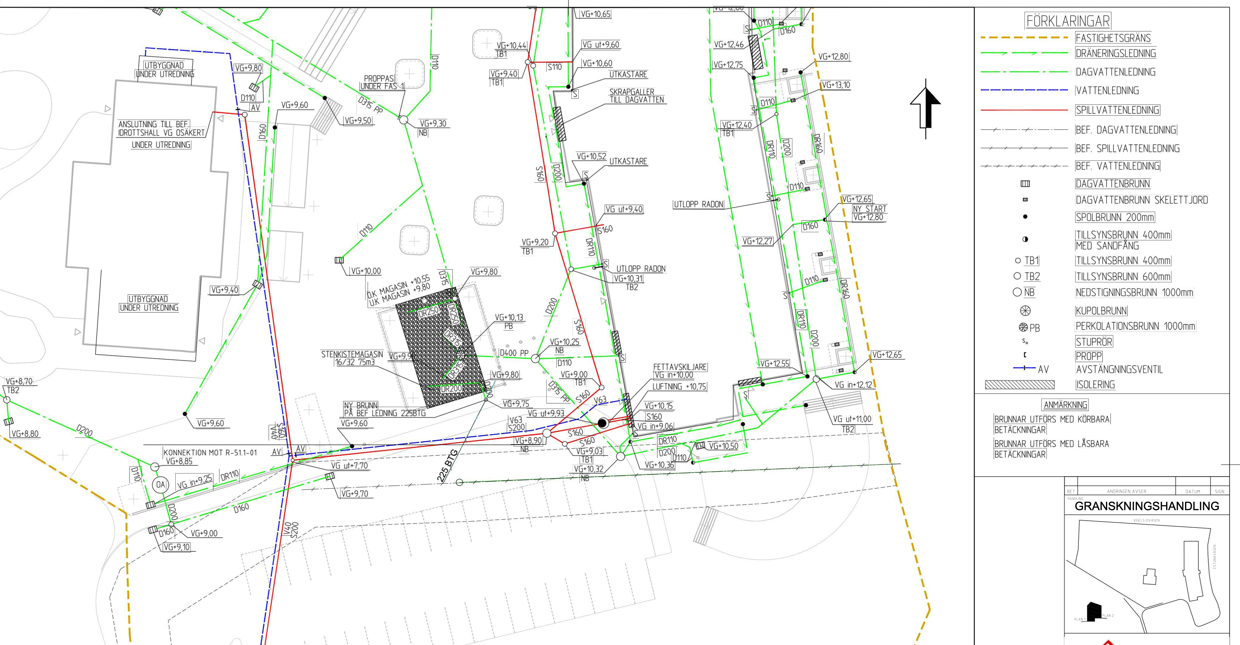
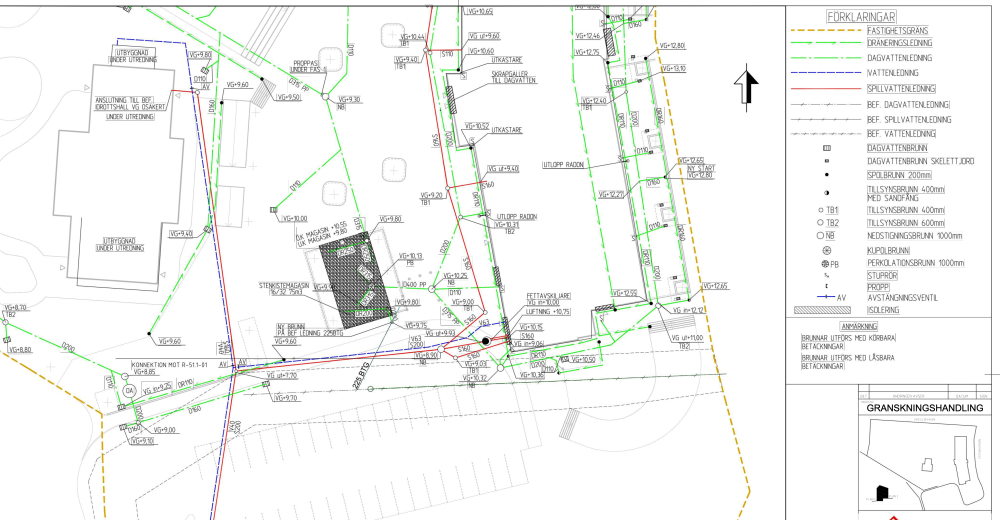
I often work in close collaboration with especially the Civil engineer doing piping of different kinds (not to sure of the English terms here), for stormwater, sewers and freshwater, including retention solutions and calculations. Attached below is a drawing of what a typical drawing might look like. I started my own little firm a year ago and work has been steady so I'm considering hiring the engineer to be able to offer a more complete package. Typically the engineers I've worked with do this very old school with non-intelligent objects in 2D, in AutoCAD. Some have ventured into more advanced modelling in Civil 3D or NovaPoint but it's rare. So I'm contemplating wether anyone here has any experience in Vectorworks being used for this type of work? I guess for regular "dumb" line models in 2D I know what's available but I haven't ventured into the piping parts of the software, although I've noticed there are some tools for this.
- 1 reply
-
- 1
-

-
NURBS modelling for curb line
Anders Blomberg replied to Anders Blomberg's topic in General Discussion
I tried to create a retaining wall site modifier (red lines below) with the newly created road/curb but it doesn't seem to behave to well over a curved road. It was also created at the wrong level but moving it manually to the correct location was no problem. Anyone had any luck with the retaining wall site modifier with roads?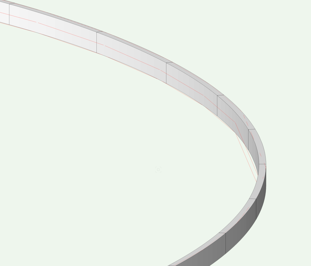
-
NURBS modelling for curb line
Anders Blomberg replied to Anders Blomberg's topic in General Discussion
@Tom W. I didn't know about that specific workflow so thanks for educating me! I did however use the road tool by itself and it's as close as I get to what I need at the moment. I'll experiment some more with it. I was however hoping to be able to control NURBS in the same way for use as site modifiers as well. @markdd Thanks! -
NURBS modelling for curb line
Anders Blomberg replied to Anders Blomberg's topic in General Discussion
I believe both those solutions will result in a slope that is just one directional? I'm hoping to have the slope along the line, including along curves. Drew some arrows below to illustrate. Or do I misunderstand you?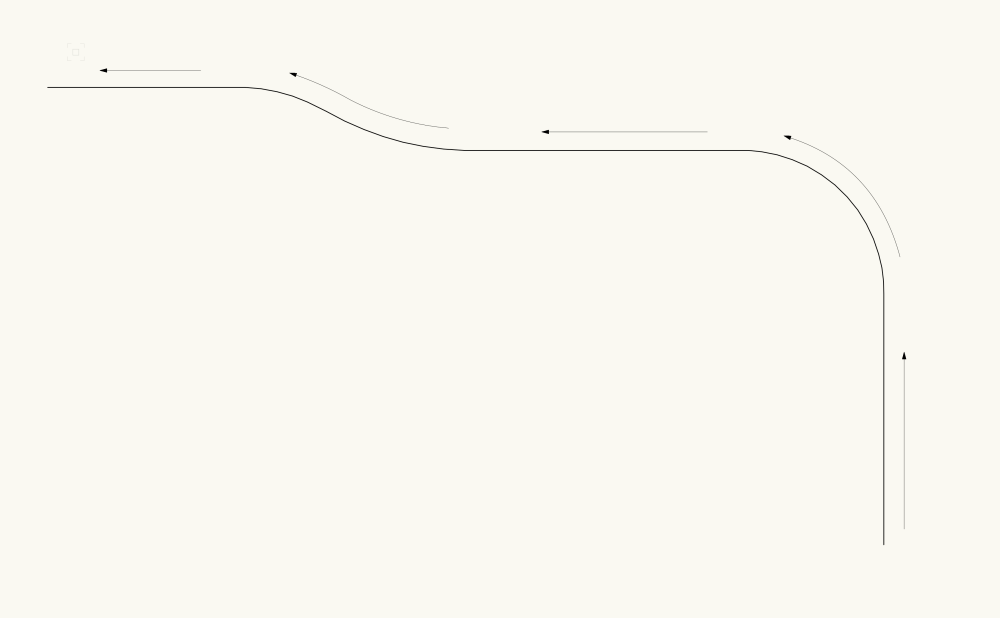
-
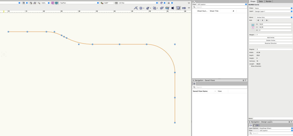
I'm experimenting with using NURBS for defining curbs. I'm not in any way experienced in NURBS modelling but have spent some time looking through tutorials. Is there a way to give a NURBS as the one below a constant 1% slope along the line? Or a continuous slope between a +0 elevation in the beginning to a +1 elevation at the end? Or even a 1% downward slope for half of the line and 2% upward for the rest of the length (with a controlled vertical radius at the break point if one could wish 🙂)? NURBS.vwx
-
So we ended up using photogrammetry in a recent project I did which turned out really cool I think. I had the surveyor send up a drone from which he created a DTM via photogrammetry and an orthomosaic Geo-TIFF photo. As I'm still trying out new stuff I didn't really know what to ask for but he ended up exporting a DWG TIN model from which I could create my own site model in VW and drape it with the ortho as a texture. It's all geolocated and everything so I'm all happy. I guess this might be basic stuff to many of you but it was exciting to me so I thought I might just share it. Skärminspelning 2022-05-20 kl. 11.28.39.mov
-
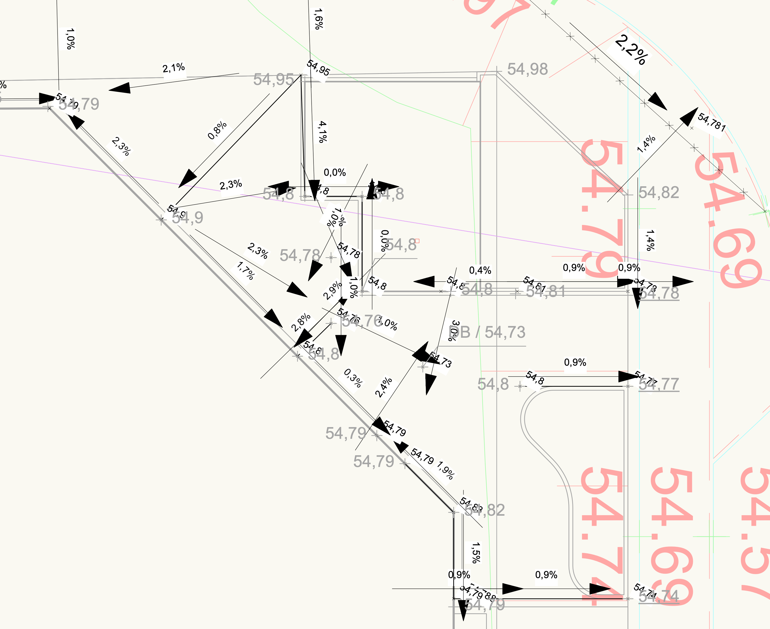
Some more development ideas: Ability to change the size/look of the slope arrow. It quickly becomes chaotic when working in tighter areas, as seen in the picture below. I often do grading 2D only and on sheet layers/printed drawings I typically only want to show a + symbol with the associated elevation. Currently I can't turn off both "show slope value" and "draw line" to show just the elevation value, and I won't get the + symbol. A great feature that might seem silly but many find really useful in Novapoint is the ability to change the point elevation up and down with the scroll wheel. Together with the related interactive slope values this makes it super fast to tweak elevations in detail. Would love to see this integrated in VW.