Anders Blomberg
-
Posts
196 -
Joined
-
Last visited
4 Followers


Recent Profile Visitors
3,064 profile views


-
@Poot would you mind explaining how you manage the slope along the edge line? And how do you set the grade between different vertices on the line?
-
Is there a way to assign a Tag ID value ta a certain style of Hardscape? So that I can control the tag of all drawn hardscape from within the style? So far I have a custom record assigned to all hardscape styles but I'd also want to control the values in the record from the style. Preferable just like it's done in Plants, where I can also control if the Tag ID is set by instance or by Style. I guess this is basically a question if I can have records fields in general be set to By Instance or By Style? Or is there another way? I have come up with a solution of assigning every style to different class and coupling that class to certain values via the Data Manager. Seems unnecessarily cumbersome though, so I was hoping for a better solution?
-

Multi-discipline Collaboration with Revit BIM Model and Vectorworks.
Anders Blomberg replied to dcg's topic in Workflows
I'd love to see an updated presentation @aage.langedrag, especially now with IFC4.3 coming up. As a landscape architect in Sweden we do a lot of work in the detailed design stages and while there are some videos at the university that cover this I feel there is a lack of videos going in depth with more real-world issues with complex landscape modeling and coordination for large projects. Unfortunately IFC hasn't really taken off in Sweden but I hope we're moving in that direction. I have a very similar experience that Vectorworks is the best solution for landscape architects currently. My experience with Revit is that while it is a great piece of mature software it does not cater for the needs of landscape architects. I think that the fact that there are multiple add-ons for Revit covering landscape work speaks for itself, Revit by itself simply isn't good enough at this. -
I've spoken to them about it as well and am under the impression that it might be fixed during a larger point cloud-revision. Agreed that it's an absolute pain as it is currently though.
-
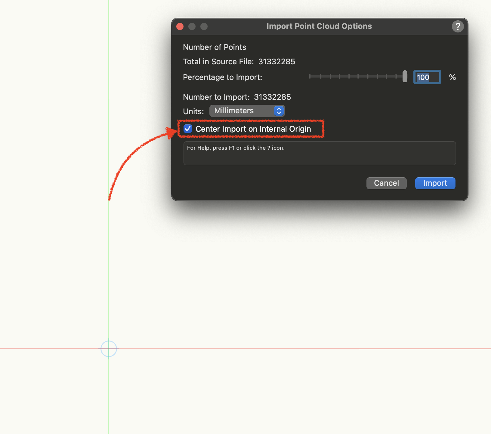
Unfortunately this seems to be a current flaw in VW. When importing georeferenced point clouds they always turn out this way. The very unfortunate solution for those of us who are absolutely dependent on proper georefencing is to import on internal origin and move it as well as you can manually afterwards.

-
 Glad you find it useful! Yes, it's been fixed, I'll upload the new version when I have some time to spare. Agreed that it should be a standard feature in VW. Maybe @Katarina Ollikainen can improve on my foundation and add it in future versions? 🙂
 -
Anders Blomberg changed their profile photo
-
Just chipping in here to say that this is exactly what I've been missing and asking for since I started using VW. There has been great additions to the software since I picked it up 2 years ago but this would beat them all by a mile if implemented properly. And as an extra input, we would need this to work for any graded surface, not just a horizontal flat surface/pad. Exact/configurable slopes above and below ground are vital to landscape modeling/design to a lot of us and is a major reason to why we still use other software unfortunately. @Eric Gilbey, PLA as mentioned by Åke, the Grade Limit from Pad creates some unexpected/hard to predict results so I would suggest the tool gets pulled from the software. Just my thought 🙂
-
Thanks for the input, watched the video a while back but forgot about it. I might try the stitching next time. It's valuable to get data on surrounding ground and I believe the Lidar does a good enough job there for simple jobs as long as drifting isn't becoming to much of an issue. Traditional measuring with yardstick etc. is a pain outdoors as nothing is flat/vertical/parallel asf. so some kind model is a big win there.
-
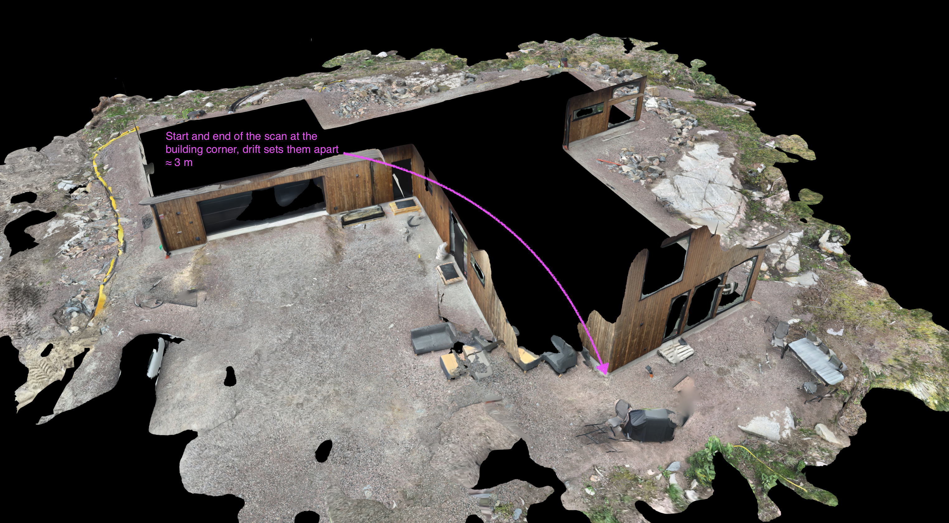
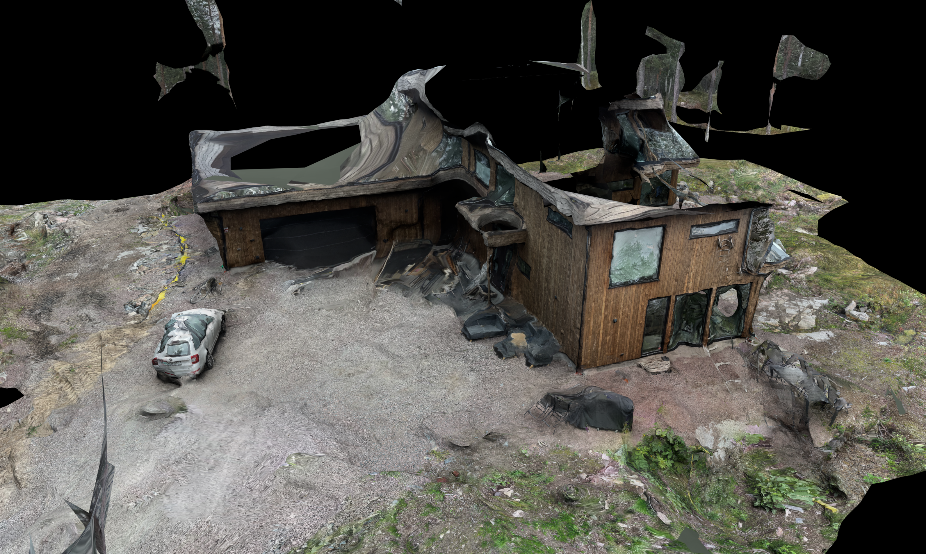
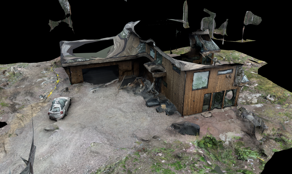
Hi! Thought I might as well jump one of the old threads on this topic. I recently visited a site and did 2 captures to evaluate different methods. I did a Lidar scan with Scaniverse and also did a "photos to 3D model" in Nomad, both via an iPhone. Ended up with ≈200 photos for the latter method. The nomad scan is way better in most ways but seems to drift considerably while scanning which becomes obvious when walking around an object (a house in this case). Guess this is due to the linear nature of the capture. The Photos to 3D doesn't suffer from this but rather has a molten metal kind of style to all surfaces, so they are considerably less accurate than the Lidar scan. Has anyone got any recommendations for how to achieve better results for a project like this without calling the surveyor? A far fetched idea that came to mind would be to get an Apple Watch Ultra and hope that the higher accuracy multiband GPS would sync to connected devices and improve upon things but I guess it's unlikely? I've also got a little drone, a DJI mini 3 pro, but haven't really been able to utilize as I hoped for in these cases. Scaniverse Lidar scan: Nomad "molten metal", Photos to 3D:

-
Sharepoint and Project Sharing
Anders Blomberg replied to lisagravy's topic in 3rd Party Services, Products and Events
Thanks, BOX was my main potential option at the moment as it seems to be a professional solution with good version handling among other things. Interesting to hear that you've had some bad experience with it. I'm really happy with cloud storage in general so owning hardware would definitely be a step backwards in my mind. VPN's I've used in the past have been underwhelming. My main potential worry about the cloud solutions is that some customers have higher security requirements and won't accept server locations in certain countries/regions, US-based servers are surprisingly a major problem. I think our Sharepoint is currently set to the very unclear "Europe" setting. So far I haven't run into any issues as mentioned though but I don't want to get stuck in a solution that turns out to be a problem down the road. Would be very interesting to see a presentation on the subject with reports and experiences from the current options. -
Sharepoint and Project Sharing
Anders Blomberg replied to lisagravy's topic in 3rd Party Services, Products and Events
@shorter Out of curiosity, do you use another service for cloud storage and/or as file server? We're currently using Sharepoint as the sole solution for all file storage needs for my little company of 2 people. I'm currently the only VW user as my colleague uses Autodesk products. So far we haven't had any issues but I'm trying to prepare for the future and using Project sharing more extensively. -
Switching from PC to Mac Ecosystem - any regrets?
Anders Blomberg replied to StagehandPv's topic in Hardware
I too used to work in a windows environment for many years. Now I'm raised with a Mac as a child so I'm very familiar with the system, not so much with windows. That being said I really didn't have too many issues using the windows machines and was rather pleasantly surprised with the OS nowadays. There was an IT department managing the computers though so I didn't have to care about that. Since starting my own business I decided to go back to a Mac as I'm more comfortable with that and enjoy it more. The ecosystem also makes it super simple to switch between devices. When hiring my first employee ( a civil engineer) in January we decided on getting a windows machine for him as he's heavily dependent on Civil 3D and Novapoint. It might not be ideal but has so far worked very well without to much hassles. We run Sharepoint as a file server. I'd say being able to use a Mac at work is making my job more enjoyable but there are som downsides I see: I'm missing out on software that is pretty much ubiquitous here, namely Revit, Civil3D, Novapoint and Bluebeam. I also miss out on path tracing in Twinmotion, but believe I can use a virtual machine for that if needed. When hiring almost everyone is familiar with Windows, that makes a switch to Mac for them an expense I might not be interested in taking. I might switch to a PC for work in the future because of the above but things are working well enough at the moment so I'm currently staying put. -
I bought a Spacemouse wireless last year, been working flawlessly ever since. Used on M1 and M2 in VW -22 and -23. Not a heavy user though.
-
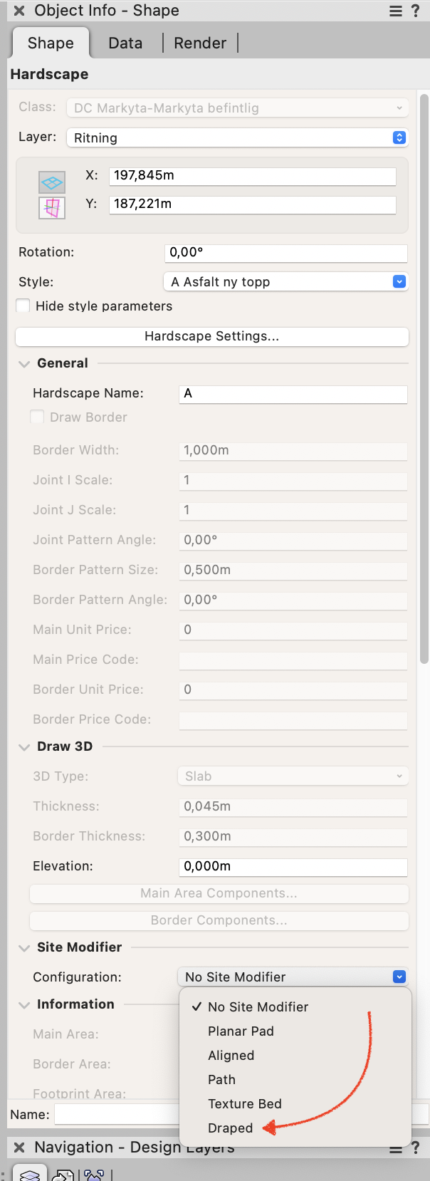
@AcetoLA Did you find it? It's under Site modifier. Agreeing on the fact that it's a great feature! I just hope we can get some better grading tools now! I have some issues draping larger areas, anyone else seeing the same thing?
-
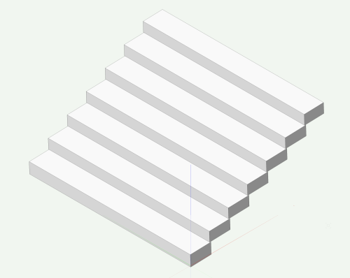
Version 1.0.0
46 downloads
Stairs according to the standards of the Swedish city of Gothenburg. Swedish 2D drawing of the principles attached. Not so sure of the English terms for some of the parameters. 6590-P_Trappor-principer-for-racken-och-kontrastmarkering.pdf