Rob Norris
-
Posts
7 -
Joined
-
Last visited
-
Section viewports-annotating heights and elevations
Rob Norris replied to Rob Norris's topic in Site Design
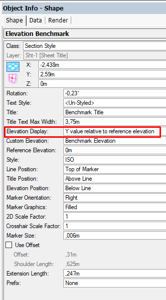
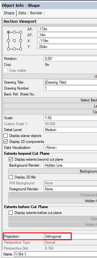
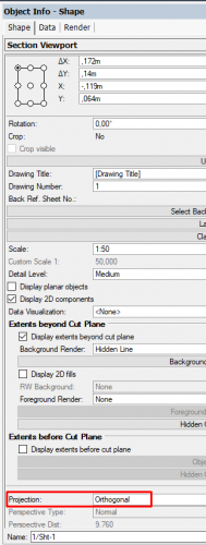
OK: thank you both for your help, i now have the answer why it wouldnt work, which ill put here for future generations! 🙂 the main reason i couldnt get it to work was becouse id overlooked two important settings: 1-Section view port needs to be set in orthagonal projection 2-The elevation benchmark itself should have elevtaion display set to "Y value relative to reference elevation" its a learning process every day! 🙂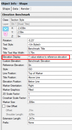
-
Section viewports-annotating heights and elevations
Rob Norris replied to Rob Norris's topic in Site Design
quick update: i spoke to my supplier and he says that its a bug/issue in the current version of Vectorworks. so maybe thats why i cant get it to work for me. -
Section viewports-annotating heights and elevations
Rob Norris replied to Rob Norris's topic in Site Design
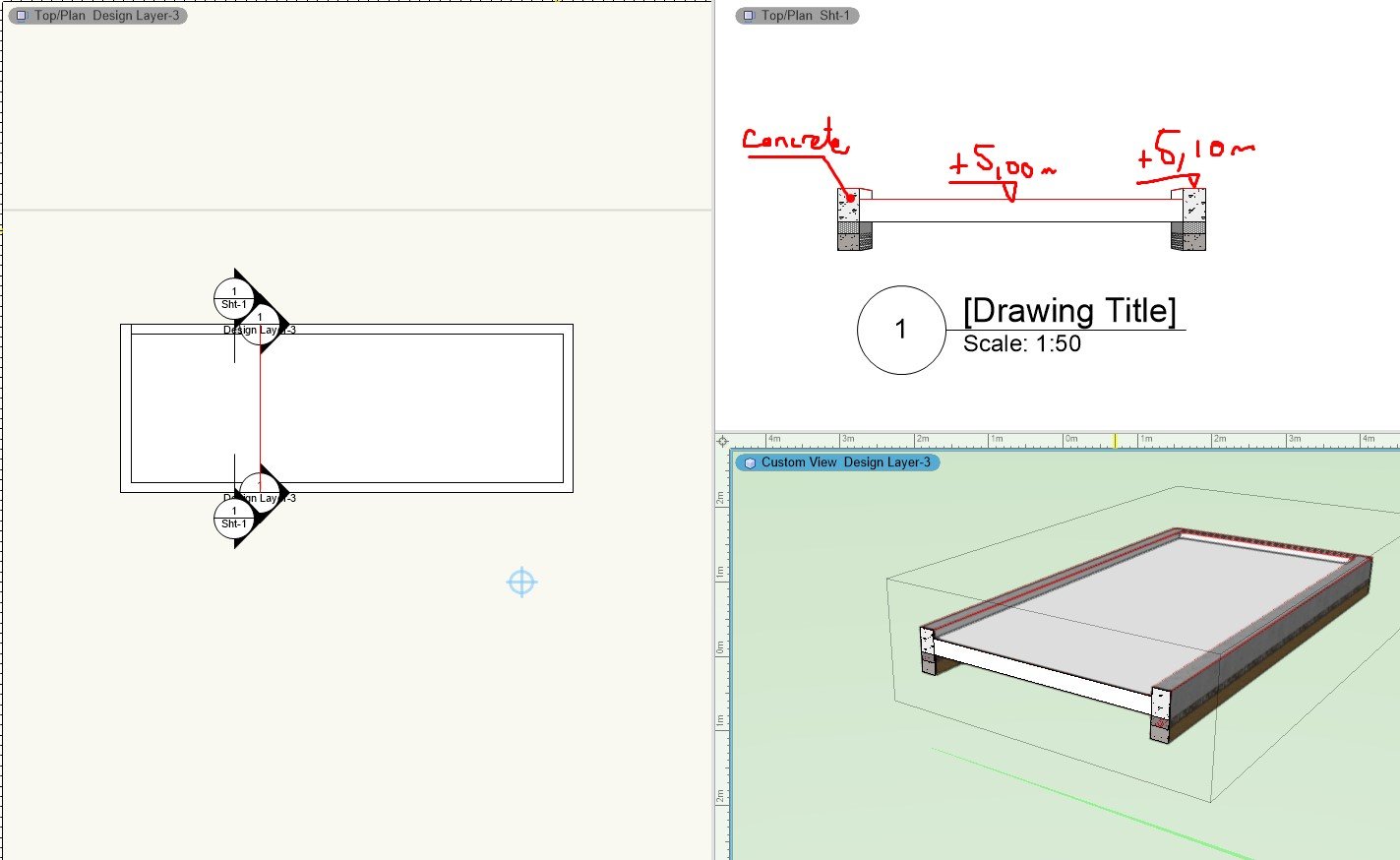
Hi, thank you for your input, but i feel like i am missing somthing (im faily new and only get a chance to learn this program sporadically) It seems to me that the elevation benchmark tool is fairly passive. if i move one of your elevation benchmarks, the elevation stays the same the only way to alter it is to mess with the settings/objectinfo. What i would like to do is be able to place, copy and move these labels so that the real world eleveation int the section changes with it. -
Hi, i have what i believe must have a very simple answer as is seems like such a basic function, but after hours of googling and searching the forums, i cant find nothin'!😬apologies for being an idiot: im not even sure if i have the correct terminology? i create a section viewport and i would like to annotate it. i would like to use a tool and click on a point and it give me the elevation/height automatically eg is there something basic im missing or is this a time where its actually a little more involved than one might have thought. as a secondary thought i would also be good to label the materials autmatically. ' Any help welcome; advice or a link to a tutorial video or similar 🙂 ive also uploaded the file so you can see what ive acheived so far! Rob 210511_hardscape test.vwx

-
@Tony Kostreskiand @jeff prince thank you so much for that. i feel like a bit of an idiot now, searching deep in the graphic properties in the site model settings! when it was there i front of my face the whole time!:D but great advice about using the class settings over object settings. (its a golden rule of mine coming from acad too). you have to know these rules so you know when to break them!
-
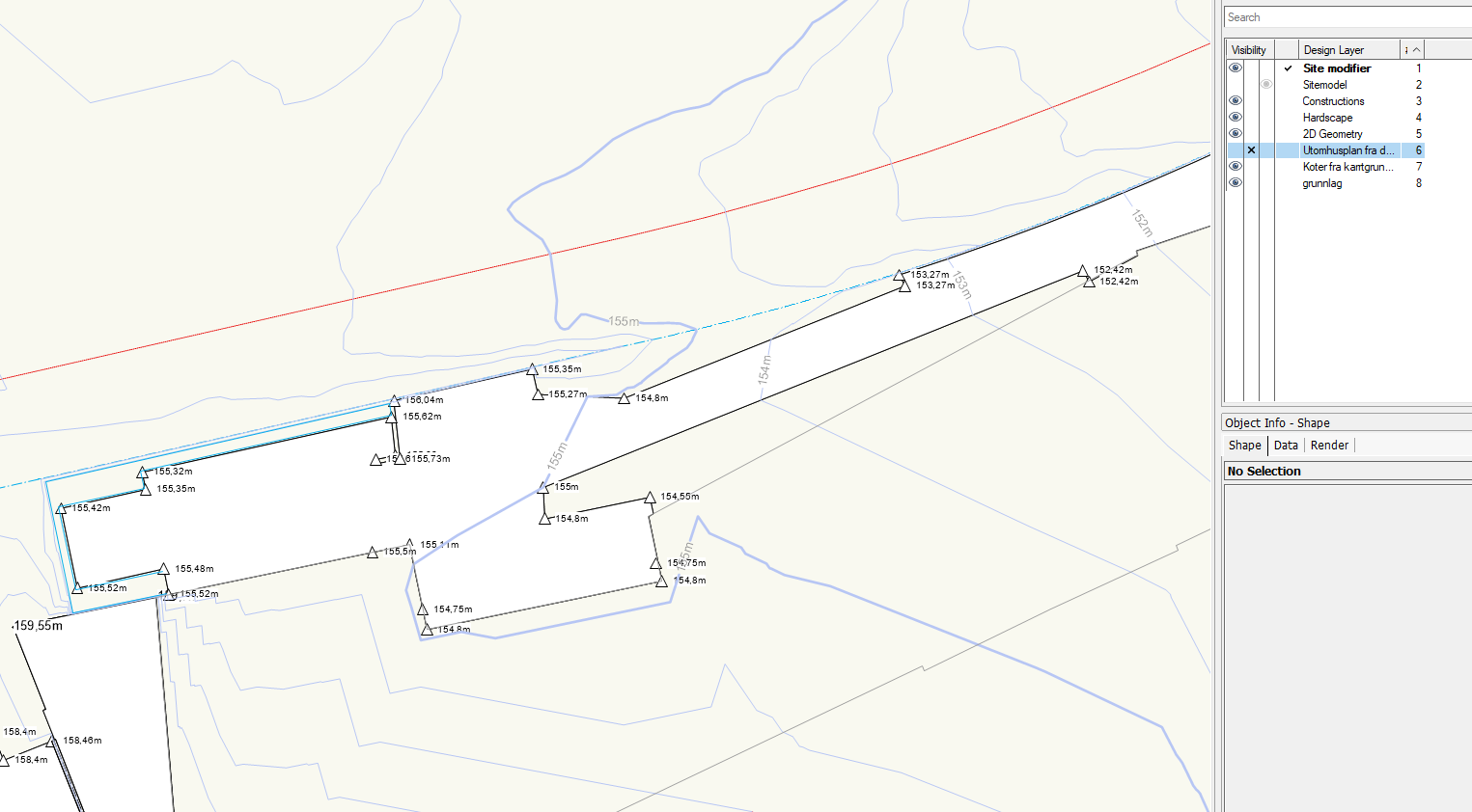
Hi, does anyone have any good links, tips and tricks to model curbs and edging? I often need to have an edging around part of my hardscapes which are maybe10cm or so above the hardscape its self (also sometimes the adjoining planting will be lower). Whats the best way to approach this? i have 2 main challenges to overcome: modifying the site modell itself Modelling and controlling an object that represents the curb stone (for visualisation and quantity takeoffs). A way to combat both of these would be a curb object that alows allows allignment at a different level on either side. but i understand this tool does not exist yet. my idea (which i have not tested yet) would be to create two 3D polygons that act as site modifiers, and then use somekind of modified railing (or wall object) as the curb stone, that would be alligned to one of the polygons (or maybe would have to be adjusted separately). Does this sound feasable? I am very new to both Vectorworks and object based modelling, and having used civi3d for the last 10 years, i am probably thinking about this completly wrong, so apologies if what i am saying is complete nonsense!🙃 Any advice would be more than welcome- its an exciting but confusing new world in Vectorworks!
-
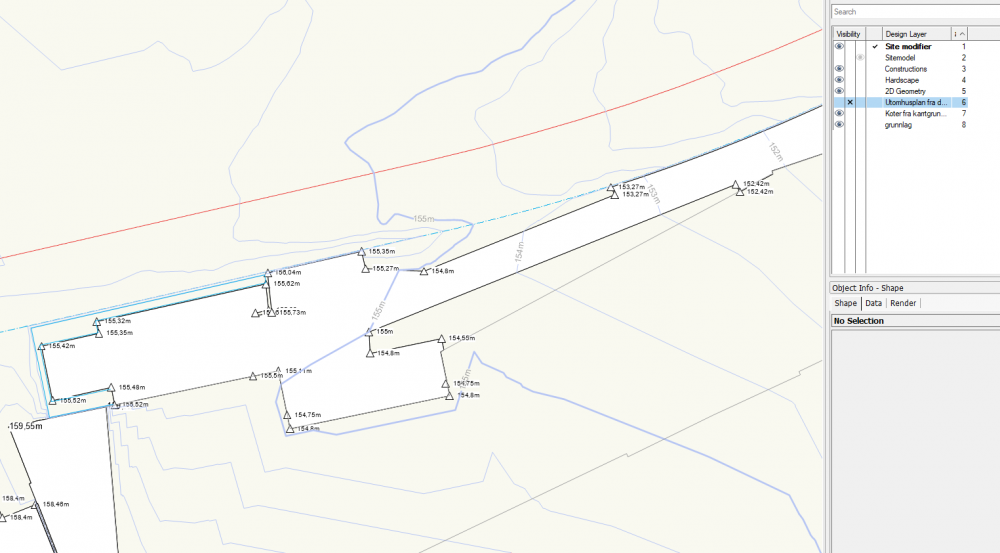
Hi, im new to Vectorworks and im not sure the best way to show contours on top of a hardscape etc. My goal ultimately is to build up the model so it can be used as both to produce both 2D plans and a 3D model. When using hardscapes, i therefore want to be able to use the hardscapes as both a 2d visual element and as a 3D object. my issue is this: i want to be able to have the contours and thier lables visible over the hardscapes. i cant find a visiblilty setting that only shows contour lines and text, and not the white infill of the site model. The work around i am using at the moment is to have the sitemodel layer greyed out, which is fine for the design work and model building, but not ideal for when i eventually producing drawings. It would also be good NOT to have them show through stairs and retaining walls, but i guess this could be solved by having the "constructions" layer above the "site model" layer. ive not actually used sheets much (or even at all really!😇) so maybe there is something obvious im missing there? Thank you for any help or tips, Rob