Poot
-
Posts
134 -
Joined
-
Last visited
Content Type
Profiles
Forums
Events
Articles
Marionette
Store
Everything posted by Poot
-
Have you made a saved view of your model? I think this is needed for the web palette to work.
-
Great! I will definitely test it out. I'm a landscape architect, and have worked a lot with SD/ControlNET/Etc. but been too lazy to do my own lora training for landscape. It can often be hard to get good results because of the complexity in outdoor scenes (where building geometry is absent, or of minimal importance) which have a variety of complicated/nested/overlapping geometries, materials, and objects. VW has a large userbase in the Landscape Architecture world, so it will be interesting to see how it works for landscape as the scope of image training is a bit different. I will give it a shot over the next week and post some feedback.
-
I think the closest way to get something like breaklines is to use the Grade Network lines to connect to existing site model heights along the path of the road/geometry you'd like to use. While not as straightforward as the breakline function in Civil, it should give you the same result with the least amount of extra work. I don't think any civil road engineers use VW so it's unlikely a feature to get much attention.
-
That would probably help a lot of people into the future! They have done well with the courses/webinars on topics like GIS, but as mentioned, there isn't a whole lot specific to BIM.
-
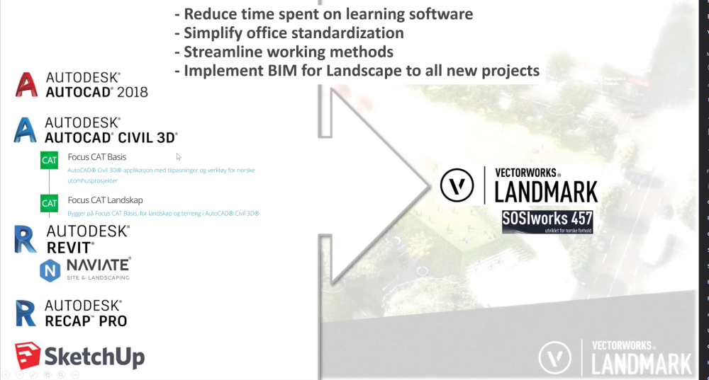
You can tell them that VW is the only BIM software built for landscape architects, full stop. You can reference @aage.langedrag who has been using VW to deliver BIM models for large hospital projects in Norway, and stopped using Revit because it simply can't compete. He is also a Revit superuser and involved in setting the BIM standards for landscape projects in Norway, so to say that you need Revit is a joke. Here is a video from him on Open BIM and IFC for Landscape Architecure . Around 9:00min it goes into detail about BIM details for landscape, useful for you. You should absolutely not be losing work, and should not be forced to use Revit. BIM deliveries are in IFC formats, not Revit. We collaborate via IFC! That is literally the point of the file standard, where a common model is built from many different software packages (engineers are NOT working in Revit, and never will). You can search the Site Design forums for posts on working with IFC & BIM. As landscape architects, it is normal to work with internal origin (aka architect drawings always at 0,0) and world project coordinates but @loic.jourdan's post is worth referring to if you haven't done this. Otherwise, it is making sure you have attached the right IFC records to your materials/objects/trees&plants/site model. There is an Ifc SiteModel record, which you can use for the site model, and everything else is usually categorized using Ifc BuildingElementProxy. This is because IFC standards have not been developed with landscape in mind, but this should change with upcoming standards to include things we use (e.g. trees)
-
 Maybe by using a snapshot of the existing site on a separate design layer?
 -
Have you tried exporting very detailed 3d contours of your VW site model in DWG format (e.g. setting contours to small intervals to get sufficient quality)? I think this can provide better results in some cases when working between Civil3D and VW. I change the 3d view of site model to detailed 3d contours (e.g. 10cm interval) and export those as a DWG to build the surface in Civil3D, avoiding problems where it misinterprets surface data. I don't know what the future of LandXML format standard is at a global level, but it probably wouldn't hurt for VW to have some kind of plug-in.
-
Did you find any solution for this @aage.langedrag?
-
Giving up om 2024 and looks like 2023 from now on
Poot replied to MartinFahrer's topic in General Discussion
AutoCAD hasn't changed their layout in a decade, so no. But then you are working in AutoCAD... -
I think @BartHays is correct, as texture mapping from a by-class setting just wouldn't be able to follow every kind of 3d geometry correctly (at least until our AI overlords take over) Even in Rhino, which I'd say has more controlled texture mapping for multi-sided objects, getting the pattern to align on a planer surface as well as a radial curve would be tricky without modelling the object and applying/adjusting textures manually.
-
Thanks for the info @Marketa Hermova. I am thinking of this, at the moment, more useful as an early-stage tool and for client presentations where it can be used to support arguments for various design choices. However, here in Denmark LCA(ECC) analysis is now required for all new building projects, and I can see that it won't be something required for landscape architects but probably desired. I will set up some sample/concept materials that are populated with the right information so I can use it on some sample projects, or perhaps used in future template/resource files. I am going to be doing some training for a large consultancy that is switching to VW, but to convince other firms this tool will be a good selling point. @Luka Stefanovic, do you know if there is any further development planned on this tool? I think it is definitely very useful as is, but am wondering if there might be improvements in terms of graphics/report output, and automation for materials entry (e.g. populating the list automatically with material quantities in use from project/model)? I think it is probably a lot of work to go from the current VECC to add some of these features (like LCA plugin below for archicad), but surely something that is going to be increasingly important especially for architects as LCA/ECC becomes required in more locations.
-
Maybe @Tony Kostreski or @Tamsin Slatter have some insight to reducing PDF sizes, or what might be causing the issues. You might need to share the file. 128mb for a PDF is insane if you are not using uber-high quality raster images with heavy vector graphics (e.g. from Adobe illustrator you can make huge PDF files for printing). Even 20mb seems a lot, but not unheard of with other software I've used.
-
I'd also chime in - a bit late- on the Logitech MX Master being a great choice. Rock Solid, dependable and with several extra, but not too many, buttons for helping with drafting. It works on most surfaces without a mousepad. I preferred the button layout and size (I have big hands) of the Steel Series Rival, but the rubber grip wore off the side (sticky) after 2-3 years, and it needed a mousepad.
-
I've had this issue in AutoCAD/Civil3D as well, depending on the publishing settings and drawing size/complexity. If there is a lot of vector geometry, it can slow things down. Sometimes having a raster output for the PDF, for collaboration and easy commenting, was the best solution even though the quality was reduced compared to vector geometry. In VW, I am wondering if page-based hatches aren't the way to go....vs. world based. Not sure if it applies to your situation, but world-based hatches definitely make pdf files for large plans/plots much more dense. Of course, this would have a lot to do with office standards for drawings.
-
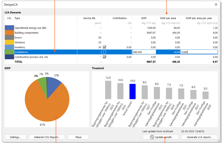
I've used that a little, and it is pretty good for early phase to help make design choices as well as very easy to use -- but it is more of a guideline since its not directly linked to specific products, materials, and plants. I think it's good to help make better choices, but wouldn't be enough to use with clients for many projects. I am more thinking about adjustments to tools like the Energos/VECC tools in VW architect packages which use your resources/material information to make exact calculations, but tailored to Landmark. It may be some Landscape architects have used the existing worksheets for our hardscape/landscape areas and fixtures/furnishings....but I haven't been able to find anything. Maybe @Luka Stefanovic has a better idea? ArchiCAD has a nice plugin for Life-Cycle Analysis, Design LCA which would be something to shoot for. I think there are also similar options for REVIT, as these are becoming very valuable/necessary tools for many projects.
-
I am just wondering if anyone here has worked with the VECC or done Life Cycle Analysis using VW/Landmark? There is some material and tutorials online, but its geared towards architecture (lots of talk on windows) and with very little adaptation to the negative carbon aspects of vegetation. The VECC tool looks promising, as it allows material properties to be used for carbon budgeting...but perhaps could use a landmark specific format. Anyhow, hoping someone here has some experience with this under their belt 🙂 Cheers POOT
-
Have you doublechecked that nothing but text is selected? If I have a single instance of another type of non-text object I get the same error/prompt for z-values. Maybe check your magic wand settings? Or try a test by manually selecting a single/few text blocks directly and running the script.
-
I'm able to convert the text into 3d loci using the script in the file you uploaded. I used magic wand to select all the text objects, then ran the script from the Resource Manager, and got all of the text objects as 3d loci I've also used the same script on other files I have where the text/height values are in Brackets, and it worked no problem.

-
Landscape Area to Hardscape Object, or vice-versa
Poot replied to Neil Barman's topic in Site Design
I wonder if a script might not be able to accomplish this? Maybe @Pat Stanford might know if thats possible... Here is a link to a post for with script for batch renaming, which might be able to be adapted -
Stake Tool - Remove Slash between Description & Elevation?
Poot replied to Selena_VBD's topic in Site Design
This was posted a few days ago, with the best fix so far. -
Internal origin and geolocated cad file import/referencing
Poot replied to DDD's topic in Site Design
Have you changed/altered the Internal or User Origin of your drawing? If you haven't, and it is 0,0 then georeferenced drawings/objects will be located at their proper cartesian coordinates (x,y) which are almost always pretty far away from 0,0 since they are real world locations. 0,0 will be the origin point for the coordinate system you are working in (since there are many) As @Tom W. suggested, use the Geolocate tool to reset the User Origin close to your project (we often do this at a predefined point for the project for coordinating between disciplines). It is also important to have a 0,0 close to your project to avoid issues with 3d viewing/graphics (caused by harder math with big numbers based on Internal Origin coordinates).The Internal Origin will always refer to the origin of the coordinate system, and you can change between User/Internal Origin as you need. Go into the menu Tools->Origin->User Origin . If you need to import/export a drawing with your project origin, a 0,0 close to the site, then you keep the drawing centred on the User Origin. If you need to export to an engineer, you often change back to Internal Origin to put the project in its real-world coordinates. -
Where did you read that ArchiCAD sourced material from creators? Stable Diffusion is an open source model that also uses smaller models trained on any imaginable type of source material, not specifically creative commons or licensed, to cater to specific styles (realistic, cartoon, architecture, etc) There is some likelihood that people at ArchiCAD trained their own model within SD tailored to architecture renders, but I am skeptical they built it using only freely available material. In any case, the base model of Stable Diffusion has been trained/developed from scraped internet content, so it is not crediting creators. This doesn't mean that all uses of it have to do with giving creators credit, since there is a lot of general purpose material on the internet with no commercial or artistic relevance. While copying an artists style, specifically, is wrong and sh** behaviour, I think it can still be used fairly even having been trained on various material so long as what you are prompting/creating is not ripping someone off. We do this with music, food, culture, etc, so fair usage is very achievable.
-
They are basically just wrapping a ty version of the Stable Diffusion API with ControlNET. I don't think it'll be hard for the vectorworks team to figure this out. Good move though by ArchiCAD to be a first mover....but I can't imagine they will be exclusive on this for long. The models will still be hard to make good scenes for landscape until someone trains some custom models with quality landscape specific material.
-
See the thread below. You may have to adjust the size of the area you are using for the geoimage to get better resolution.... but the last I checked it was still hard to get HD images (been awhile)
-
Wow, thats great @Benson Shaw! This was such a PITA issue...its such an important part of a clean plan....and that tool seems to get part of the way there to having a clean plan without having to do all the labels yourself. I still think it needs a bit of attention to be able to place the numbers above the lines, but this is at least workable.