Anna Arbetter
-
Posts
8 -
Joined
-
Last visited
-
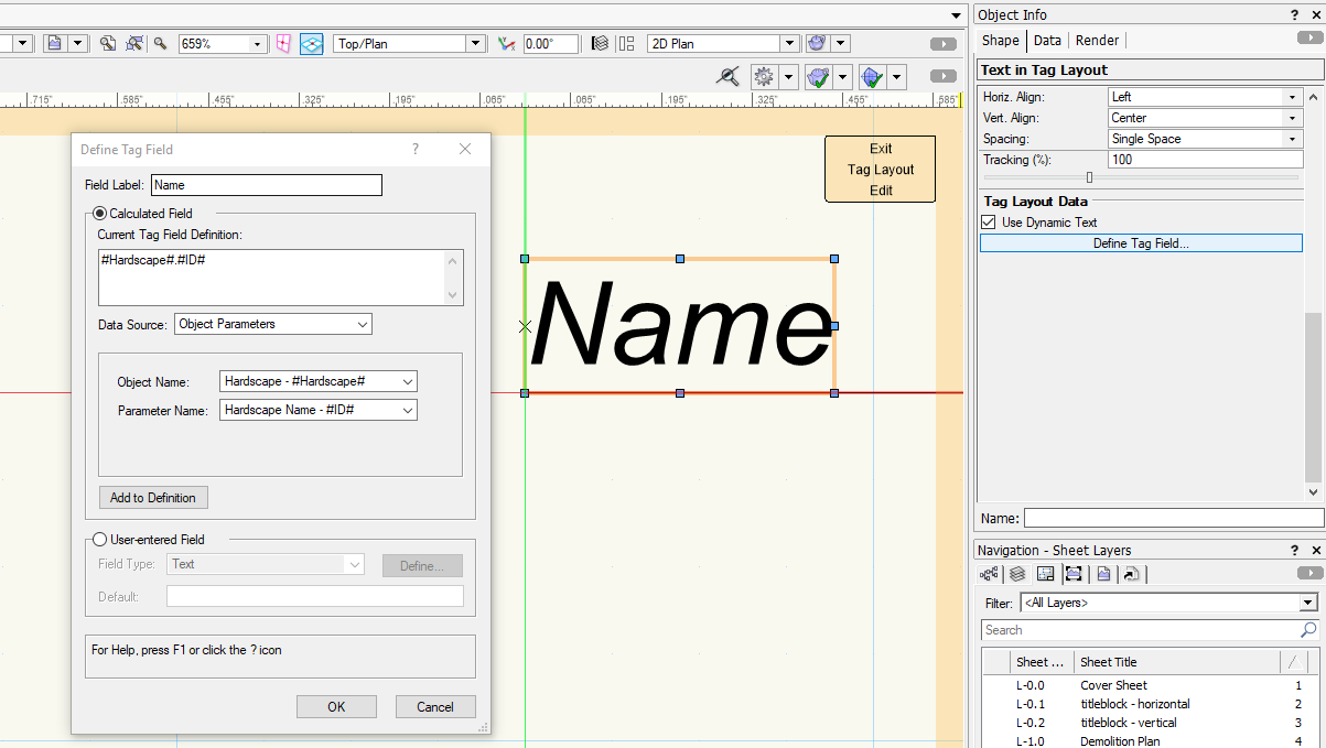
Make sure you set the definition of every text box (and as KIvanov says above, make sure you are aware of every text box). See attached screenshot. Select a text box, go to the OIP, scroll to bottom, select tab called Define Tag Field. What is shown in the box is the definition. My example is a hardscape. Perhaps yours still says "window".
-
Olaf, I tested your method using the Number Stamp and indeed it removes a few difficult steps. To get to the place where you can edit tag layout, you could also find your Data Tag Style in the Resource Browser, right click and select Edit. In the bottom of that box, select Edit Tag Layout. In layout mode, select a text box. In the OIP, scroll down to the section called Tag Layout Data. Select the Define Tag Field button. If the info in the box for "Current tag field definition" is not what you want, delete it. Then from the drop-down menus below, select your Data Source, then below that make the selections that apply to your Data Source. Then hit the "Add to Definition" button. This will load that text box with the data from that field or parameter or whichever applies. Hope that helps. Anna
-
Kevin McAllister, Your method worked. However, I still have the issue that it seems one Data Tag can only apply to one record format. I'd like to apply several record formats to one data tag since they will all use the same tag formatting. When I try adding multiple record formats to a single tag, the data tag stops working. What I mean is, I want to label ditches, wetlands, and streams all using the same data tag and all displaying the "Name" field from each record format. (these are GIS shapefiles that come in with their own record format.) Here is my own list of steps that I cleaned up from the list of steps you made: How to create a “Record Format” Data Tag from a smart object Data Tag: Place a data tag on any smart object (e.g. a hardscape data tag on a hardscape. It doesn’t matter what you use). Make sure you also have the desired Record Format in the file. In the OIP, open Settings tab, “convert to unstyled” Click on Edit Tag Layout click on the/one of the tag text elements you'd like to redefine With it selected, scroll to the bottom of the OIP and click on the Define Tag Field button A dialog will open where you can define which Record format it will pull data from (do this for each text box within the tag) Once you're done, exit the Tag Layout Edit and exit the Data Tag Settings dialog In the OIP, select “create new style from unstyled” The original tag will now not apply to the smart object is it pointing to. To relink a tag showing the exclamation point marker, click on the marker and drag it to an appropriate object (one using this record format) Thanks for the start!
-
BSeigel, I have seen this video. It does not cover the issues I've addressed. It's fine for advertising and for those who need to label smart objects. I need to label objects that have data records but are not "smart objects" made from a VW tool.
-
I WISH there was a video for how to make custom Data Tags. I'm trying to follow along with the description in the Help Menu but it's hard to find the things they describe. This is my first time using Data Tags. I need to make custom data tags for objects in my file that are not standard VW objects. I tried unstyling a Hardscape Data Tag but it is still looking for my object to be a Hardscape. My objects are lines, polylines, and symbols that I brought in as GIS shapefiles. The have record format data attached and I want to use Data Tags to callout data in the record format (e.g. ID, name). The VW Landmark 2019 webinar made it sound so easy. Argh.
-
Attribute mapping problem with tiles
Anna Arbetter replied to Anna Arbetter's question in Troubleshooting
BSeigel - I was just preparing to send you the Tiles in a separate file and my boss says it's working for him today. I checked it out as well on my own computer and it is working for me. So I suppose there is now nothing to share with you. I'll post the file if it occurs again. Thank you. -
Attribute mapping problem with tiles
Anna Arbetter replied to Anna Arbetter's question in Troubleshooting
A Tile fill. -
(I'm writing on behalf of my boss here). My boss has made tiles for hardscapes and is finding the handles of the Attribute Mapping tool do not match the square in the Tile he made. When he moves the Attribute Mapping handles to make an adjustment, the pattern does not move to reflect the change. He had this problem with a duplicated Tile so he made Tiles from scratch and it is still happening. Also, it crashed once while trying to make these changes.