Bunbun
-
Posts
44 -
Joined
-
Last visited
-
Thanks Pat and Jeff. Sorry for the delayed reply, in the end I just issued the schedule as a whole with separate excel sheets for the beds as I was able. to turn the selected beds on and off and then export. Having read Jeff's reply, I realise that you can format the worksheet to separate into different beds (A B C D etc) but I didn't have time to find out how to do this. I'm not very good at Excel either which doesn't help but I would like to learn how to do it for future reference. I look forward to the further instructions, Pat. The only real planting vid I could find on VWX university was the "Deep dive into Planting" which was useful. Maybe there is another vid guide covering formatting options for the schedules somewhere?
-
I've made a large planting schedule for a project which is divided into different areas / beds. I want to create a separate schedule for all the beds. I have managed to do this but I can't put more than one schedule in the drawing at once - they all revert to the same information, despite having edited the data base criteria on each. Is there a way to do this or do I have to export each as a pdf and put on the sheet layer or have separate drawings for each bed? If anyone knows how to do this or even if it's possible, I'd love to know!
-
Jeff / Landartma I found a tutorial on University which is called "A deep dive into planting plans." This is the most comprehensive thing I've found about planting, which is helpful. I basically started the whole planting plan I had from scratch which has been really time consuming to set up libraries of plants, tag styles etc. but once this is done, it seems that it should save time. Thanks for your advice.
-
Thanks Jeff Not harsh at all, thanks for your reply. I have watched what I could find on planting. No, haven't tried data tags. I'm just wanting a simple plan with simple schedule to cost but I'll try your suggestions and see if they work. Many thanks!
-
I hope someone can help! - Spent most of the day tearing my hair out with a simple planting plan and plant schedule. First, I drew out landscape areas in design space with tags. Despite fiddling for hours (making custom tags, fiddling with fonts in classes etc,) couldn't get the text to scale properly in the viewport so it showed as tiny planting beds and huge text. Then I tried drawing the landscape areas as annotation in the viewport which looked perfect but now I can't seem to get the planting list / report to show any of the plants despite having redone it over and over again. Maybe this can't be done on a sheet layer? I've done planting plans perfectly in previous versions of VWX - has something changed in 2021 or am I being dumb?! Can anyone help? I attach a file. 212. PLANTING forum.vwx
-
Can anyone solve this - could be I've forgotten something but I have drop shadow ticked in document preferences. I have a class with Trees to which I've applied drop shadows. All showing perfectly well in design space. However, in sheet layer, not showing. When I turn on drop shadows on the header bar, the whole drawing shows shadows on all the lines. Same in advanced VP properties if I tick drop shadow. I've tried combinations of all the drop shadow options I know of but can't get this right. Is there a way to just have shadows on certain objects and not all? There probably is but I can't find out how to do this! Anyone know?
-
Many thanks, Tom. Struggling to get them to understand what I mean so I'll try this. They've supplied the contours with Z values so I can't understand why they can't do the spot level heights too.
-
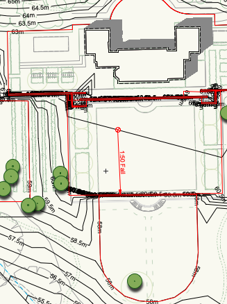
Anyone out there know what's the best thing to do with this survey to make a site model? I received a survey with spot levels as 2d info and contours with z values. The contours are broken by the text and there are overlapping polys etc. I have asked for the z values for the spot heights but the surveyor doesn't seem able to provide these. Is the only way to create stakes and manually insert the values, or should I use the contours ( which have 3D levels) and manually join them up? Any advice for the best / quickest thing to do?
-
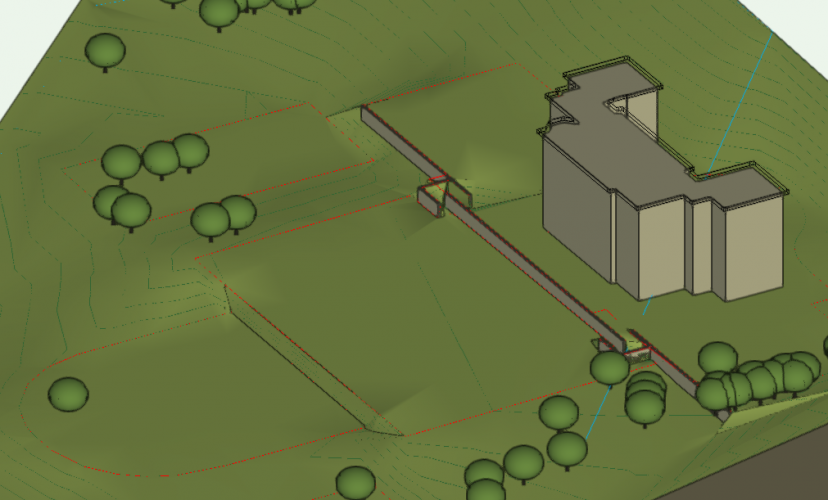
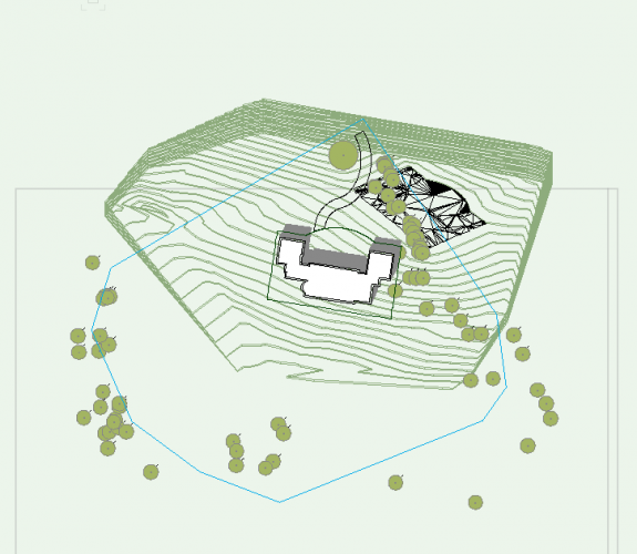
Hi Jeff, this is really helpful, also the link, thank you. Hadn't thought of making separate models but will try this, it seems logical ( now you've told me about it)! Attached is a screenshot of what I'm trying to do - house / terrace, retaining wall with returned steps, another terrace, then another below that. Also screenshot of the top view plan in case it's of interest to someone! Thanks again for your help.

-
I'm new to site modelling but have been able to create a site model and add site modifying pads and massing of buildings to test levels which is great. I want to create 3 separate adjoining terraces within the model with retaining walls and steps between. At the moment I have a forest of "overlapping site modifier" warning triangles and the contours are doing weird things between. Is there a sequence to doing this - do I put in walls first and then pads for example, or the other way around? Haven't been able to find an answer to this on the films I've watched. Does anyone have a solid process for doing this? Thanks in advance 🙂
-
Thanks all for your replies. It was a question because I've spent quite a lot of time designing my own resources so giving them to others will obviously result in them being used elsewhere but I suppose that's the rub if you're self employed. 🙂
-
I have created a library of symbols/ resources of my own. As I'm self employed / freelance, I have to share drawings but don't really want to share my symbols with everyone else. Is there a way to share drawings but not give access to the symbols? I don't know if this can be done but thought I'd ask in case someone knows the answer or has a similar experience!
-
Benson / Jeff Thanks so much - you were right, the unified view had somehow got unchecked. Working perfectly now :)) The texture bed is also showing up when I changed the render mode. There's a lot to learn but being able to ask questions like this on this forum is invaluable, so thanks again!
-
Can someone help? Just venturing into the world of 3D modelling. Have successfully modelled a site , added a building and some simple site modifiers. All of a sudden, when I change from 2D to 3D view, it looks like the attached. It was working before and still looks ok in 2d . I've gone through site model settings etc and preferences which are set to open GL. Anyone know why this is happening? Question 2 - I'm trying to add a texture bed which I've done but it isn't showing up. I've done the pad so that the contours are reshaped and then added a texture bed using the same shape, put it at the correct height but still no joy. Anyone know what I'm doing wrong? Any advice gratefully received!
-
I have made some forays into making a site model using various webinars and you tube tutorials but as a landscape designer, want to 1. Create site model from topographical information 2. Apply a 2D landscape plan to this. It all seems rather complicated compared to sketch up and different tutorials sometimes overlap or have slightly different approaches. Is there a definitive guide for landscape designers from topo to finished 3D design in written form? I know there's one about stand alone 3D object modelling but at the moment I'm trying to work out how that fits together with a site model. Some of the sites I have to design are large and not small gardens although I suppose the principles are the same. Anyone have any advice?