DanT
-
Posts
10 -
Joined
-
Last visited
Content Type
Profiles
Forums
Events
Articles
Marionette
Store
Everything posted by DanT
-
I think I ended up using QGIS for the issue. At the time the ZVI ability within VW was essentially a light cast over the adjacent terrain showing relief/shadows, with no real ability to quantify/scale the impact/visibility beyond 'intensity of light'. It looked pretty, but wasn't quite sufficient for the planning process in my estimation at the time. It may have progressed some now though. Dan
-
Hi All, I most likely missing a trick, but I can't seem to find how/where I can export my proposed model as a data set to provide to an earthworks contractor. At this stage I'm not sure what format the contractor would need, but I'm presuming something along the lines of an XYZ for them to load into their plant and merrily mound up to the required heights. My existing model was created from a topo survey at a 10m grid and the proposed model created from a series of dashed linear modifiers with z-levels set 1m, 2m, 3m etc above grade to sculpt the landscape as required. The resultant 3D of the proposed looks roughly as it should. I just need to extract it out in a format a contractor might use (waiting to hear, thought I'd tackle the problem from this end too). Any help would be greatly appreciated. D
-
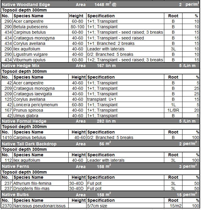
Hi all, I'm canvassing fellow landscape designers as to how they go about presenting their schedules on the drawings. I'm struggling to get the report system to display the appropriate information accurately, clearly in a manner that is appealing and consequently I'm querying whether I'm employing the right approach in creating my landscape plans in the first instance. Currently I represent bulk planted areas like woodland mixes & ornamental mixes with the landscape area tool (populated with pre-configured resources from the resource manager). Individual/Avenue trees are created with the Plant tool and areas of grass with a simple hatched polygon. I'm not sure of the best way to achieve a hedge definition (i.e. a mixed native hedge may be best with landscape area, but this doesn't show the linear meter of planting). I need a schedule (report) that essentially encapsulates the above without duplication etc. It may be that I need a mixture of reports to talk to landscape areas, individual plants, basic polygons and whatever hedges would use, and then stack them on the drawing. Ideally I'd like it to look something like: (old non-smart excel format) Can I get an idea of what approaches other people use and how they've dealt with any shortcomings the software might present. Many thanks in advance! Dan
- 1 reply
-
- 1
-

-
Does anyone know if other 10 series cards are affected (1060 etc). It sounds like a driver problem to me, particularly if weaker hardware showed better results.
-
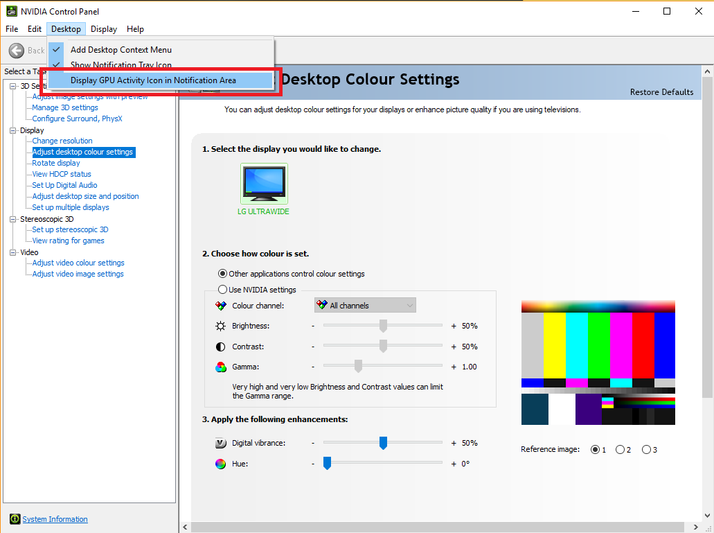
I always found it useful to check the 'GPU activity icon' to identify if the Nvidia card is actually kicking in when you launch. There should not be a problem with those specs. You could try a clean install of the drivers, or even an older/known good one? Others have suggested: There's two things to do.(steps 4, and 5) 1. Open NVIDIA control panel. 2. Manage 3D settings 3. Global settings tab 4. Power Management Mode settings, select "Prefer Maximum Performance" 5. Preferred Graphic Processor settings, change from "Auto select" to "High Performance NVIDIA Processor" These settings should use your NVIDIA GTX card for most, but not all programs. Hope that helps. D
-
Great, sounds encouraging. Thanks Pete. I'm hoping to trial 2 variants from Dell before having to pull the trigger on one of them. Thanks, D
-
Thanks for the reply Grant. It's a shame the Alienware designs are so ugly, with enormous screen bezels. I was hoping to get an XPS, but they cap out the graphics with the 1050Ti (hence my query about how future proofed it would be). Would you recommend 32GB RAM, or should the 16GB suffice? Dan
-
Hi All, Can I just get an idea of peoples opinions relating to the graphical ability of the Geforce GTX 1050Ti (4GB) (mobile version). We're a small team of landscape architects predominately working in top down plan, with a view to produce more site models going forward (we're all very new to VW). A more remote pattern of working has pushed us towards laptops and my IT refuse to move from Dell as a supplier. I'd read elsewhere that the 'professional' graphics cards (quadro/firepro) don't necessarily provide a great deal of benefit over the markedly cheaper 'gamer' options. The other specs are roughly: i7-8750H, 16GB RAM, SSD. Is the 1050Ti a reasonable choice. I was hoping for a GTX 1070, but that just isn't an option. How future proofed am I? Thanks, Dan
-
Hi All, I'm a new convert to VW and I'm going through the processes of setting up a host standard drawing elements for use in the future. I've followed the guide for the custom title block creation (http://app-help.vectorworks.net/2017/eng/VW2017_Guide/Setup/Creating_a_Custom_Title_Block.htm) and for the most part it's working as expected. I have a collection of P_ and S_ prefixes that are behaving. However, the pop-up fields are only showing up on the data tab of the object info palette. When I double click the title block the field that should be a pop-up is just a standard text field that I can populate freely. Have I missed a trick? Is there some way to force the 'double click' edit of the title block to also show the pop-up fields that I defined in the record? Many thanks, Dan
-
I'm looking to migrate towards Vectorworks and having this capability could be the deal maker. Can anyone share their experiences of using ZVI/ZTV Viewshed analysis within Vectorworks. What are the strengths/weaknesses etc. I'm from the UK and I'm hoping I can use governement aerial LiDAR data which natively comes in a .asc format. Is vectorworks capable of reading this directly, or should I be looking to add a conversion step in there via QGIS or something? Thanks, D