


Viridian
-
Posts
7 -
Joined
-
Last visited
-
So obvious when pointed out! - thank you.
-
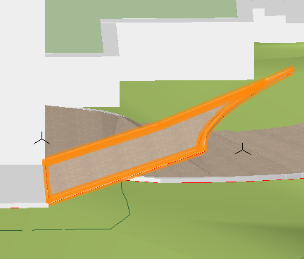
Hi - after drawing a roadway kerb the 3D view shows it projecting upwards. This feature was covered in a recent webinar but no solution to the problem was given in the video. I can't find a way to bring the high end down to site levels - see screen shot Anne
-
thanks for the thought Rick - all layer scales however at set at 1:1
-
Hi - both classes and layers are set to 'Show / Snap / Modify Others' but I am unable to force select contour lines, stake elevations or anything else in the model In addition I need to extend the boundary of the site model and have followed all the web instructions I can find. Highlighted lines show the extension I've made but the ground model doesn't fill in the space any ideas? Thanks Anne
-
Hi - is there a simple way to create gradients that fall in more than one direction, for example on a curved, sloping driveway ? The 'Draw 3D' with slab tool allows a gradient to be formed but I frequently have the need to incorporate gradients in more that one direction
-
I'm creating a site modifier on a clean model showing c&F as nil before I start The Modifier is set at a level 118000(mm) to form the base of a hard landscape area where existing levels vary between 118160 and 118020 - therefor it is all cut, yet the C&F data shows: Cut 19.4 m3 Fill 36.8 m3 with a net fill of 17.5m3 which is nonsense. The Modifier is set to Pad, Apply to Existing - though the data is the same if I change to Proposed When I update the model the readings are different C=21.2m3, F= 55.2 net fill=34m3 When I delete the Modifier the site model return to 0.00 C&F any ideas?
