Steve Riddle
-
Posts
77 -
Joined
-
Last visited
Content Type
Profiles
Forums
Events
Articles
Marionette
Store
Everything posted by Steve Riddle
-
Thank you, using the marquee selection was enough for me to complete the task.
-
How do I create a hole in a mesh without losing the texture? I am trying to use the subtract solid operation to create the aperture and the texture disappears, is there a better way to do this?
-
Hi Jonathan, Thanks, I'll have a look into it.🙂
-
Drape Aerial photo
Steve Riddle replied to Steve Riddle's question in Wishlist - Feature and Content Requests
I resorted to texture mapping in the end, It is slow to set up, but found by matching the aerial crop to the site model extents I got something close. 1022-4Brev5b (dragged).pdf -
Abort Any Command
Steve Riddle replied to Tom Klaber's question in Wishlist - Feature and Content Requests
Has there been any progress with this feature? Paint bucket tool is hanging and I dont want to force quit all the files I have open. -
Drape Aerial photo
Steve Riddle replied to Steve Riddle's question in Wishlist - Feature and Content Requests
Any progress with this feature? I am still having problems mapping Aerial imagery accurately. -
I am having trouble with a landscape plan set where I want levels to be in metres but I need details to be dimensioned in mm. After trying to resolve this problem I converted the file units to mm so I could dimension the details. This has resulted in the site model displaying contours in mm which I need to displayed in m. I expect this would be a common issue and there is a simple solution?
-
Drape Aerial photo
Steve Riddle replied to Steve Riddle's question in Wishlist - Feature and Content Requests
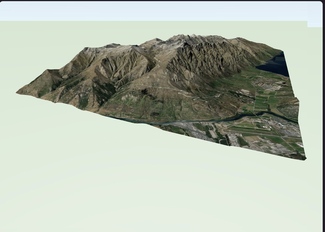
We can now link very basic aerial photography via the ArcGIS portal that will drape onto a VW terrian model, provided they are in the same coordinate system (see image below). It is quite buggy and the image keeps disappearing off the model so is not that useable. I haven't yet found a way to do this using georeferenced aerial imagery stored locally, this method would be preferable as we can customize the imagery we want to overlay and not lose it or wait for updates from ArcGIS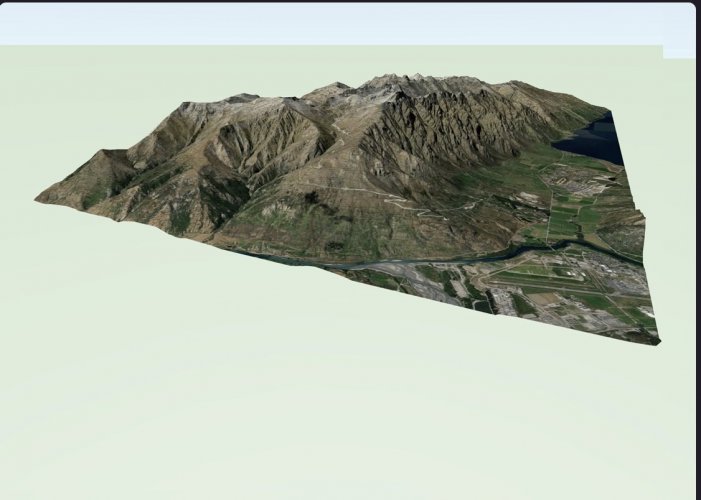
-
Site model Cut/Fill Depth contours
Steve Riddle replied to Steve Riddle's question in Wishlist - Feature and Content Requests
This is how I've been doing Earthworks plans in VW for a few years now using site analysis- 2d cut/fill area overlaid on a second viewport in open gl top view. This is the closest I can get to showing the intent with earthworks in VW, but local planners require Earthwork depth information similar to the examples above. Some way of subtracting existing from proposed model and rendering depth contours based on the difference.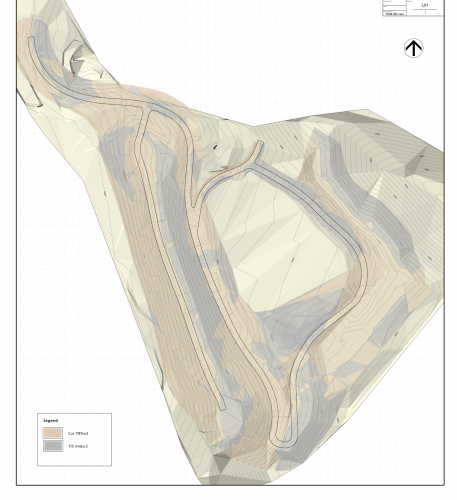
-
Normally I write in to the troubleshooting section with complaints abouts issues and thought it was time I gave some positive feedback. It was with some trepidation that I went to use the simplify 3d polygon tool on a complex 200Ha site model to make it useable, I had not much success with this process in the past and was pleasantly surprised when it worked perfectly! I was able to simplify the model to a state where it would refresh in seconds rather than minutes. This tool is a vast improvement on previous versions and a credit to the team that made it happen.
-
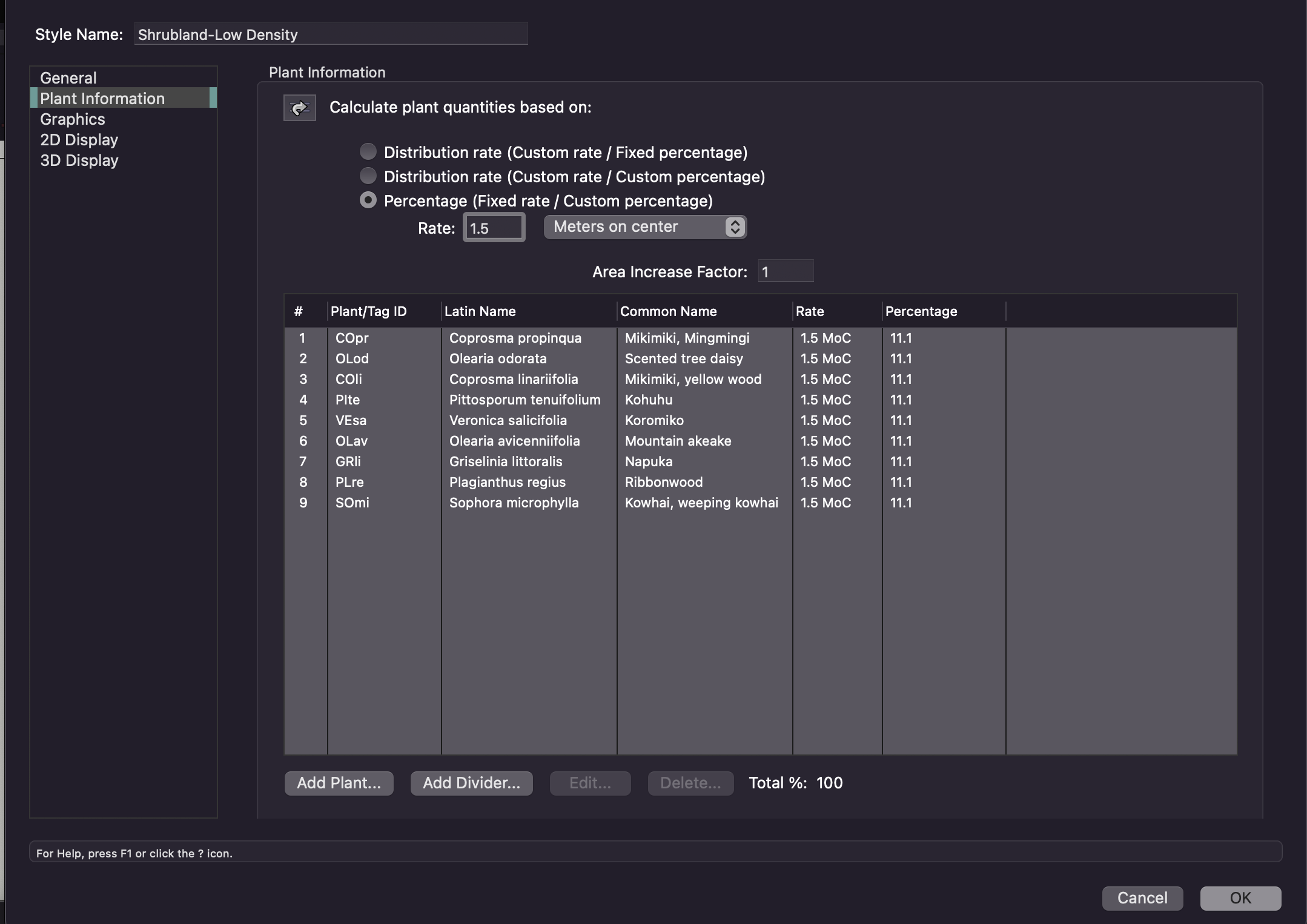
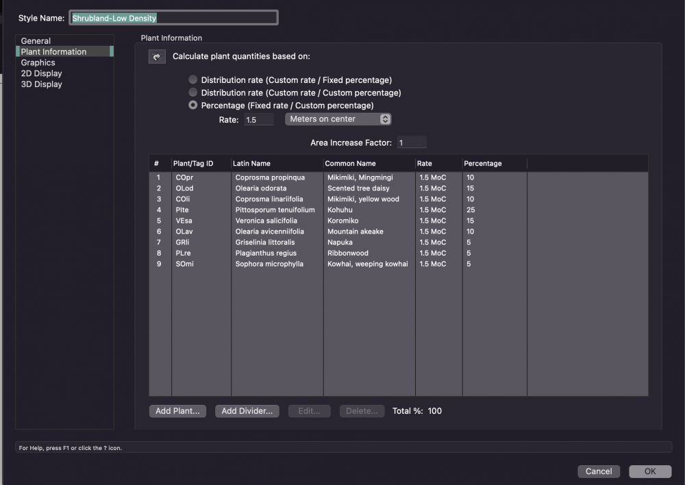
I have posted about this problem before and I see this issue has still not been resolved. When I go to change the plant spacing all the percentages change to the same, it then requires having to select each plant in the list again and re-type the percentage to how it was originally. Please fix this so that once the plant mix is set, it does not automatically change when adjusting the plant density.

-
I am having the same issue, was this resolved ??
-
I am not able to add textures via the resource browser and have never encountered this problem before. I have uninstalled the software and carried out a full reinstall and still to no avail. When I check the renderworks textures folder in libraries via the OS menu I see that it contains the default textures. Screenshot 1a.pdf Screenshot 1.pdf
-
Site model Cut/Fill Depth contours
Steve Riddle posted a question in Wishlist - Feature and Content Requests
Ability to display the depth of Cut and fill in plan view with colored contours as part of the site analysis tools. -
This is a recurring issue where any updates to the landscape Area Style result in manual tag placements moving to a default setting. Is there a way to lock the tag positions?
-
When I go to subsittute a plant in the landscape area style it changes all the percentages, See images below when I swap C propinqua with C linarifolia my custom mix percentages all change to an even mix. vectorworks needs to find a way for this not to happen every time I need to make a change. Thanks. Landscape Area1.pdf Landscape Area2.pdf
-
Site model From TIN
Steve Riddle replied to Steve Riddle's question in Wishlist - Feature and Content Requests
Having looked into it further I found that the TIN files imported, but in some files were too complex for vectorworks to convert and navigate effectively . A workaround was to import the engineers strings as 3d poly modifiers over a base survey TIN. Not a fast process as requied some conversion, but the finished model was workable this way. I think what would be helpful in instances such as this is for VW to include a tool where the user can clip and adjust the polygon count of the TIN before converting to a site model -
For some reason when I import this png as a bitmap it includes the transparency, when I import it as a resource it does not? Is this a bug or by intention? or have I missed something in the process of importing? Pattern.vwx
-
I nearly always get 3d site data from Engineers and Surveyors as a TIN surface as well as 3d contours, both are converted to 3d polygons via dwg import. The TIN surface file is survey /design accurate from the engineers while the 3d contours are only as accurate as the contour spacing. It would be amazing to have a 1 step process to quickly convert these surfaces into an editable site model without having to convert to 3d loci first then clean up the data into something the site model tool can use. From what I can tell the site model then re-creates its own version of the TIN from the converted source data. In my experience I have found this process creates anomalies in the file, and rarely do I get the site model surface to match the Engineers/Surveyors TIN. It is also very common for these surfaces to contain a lot of polygons and vectorworks struggles to Navigate these files, any improvements to this would be very welcome.
-
I have created a site model from the both data sets, the first one loooks great but has too many polygons to work fluidly. The simplified version is snappy but to coarse and over simplified, what would be ideal is something in between, but cannot get this to happen with the simplify 3d polys tool. Am not sure if its a bug, or the tool has just been designed this way? It would be a more useful tool if somehow we could make finer grain adjustments to the segment length /deviation in much the same way as the simplify 2d poly tool
-
Is these a way to simplify the attached 3d polys into a form that more closely resembles the original polygons, for some reason the simplification tolerance defaults to 1.734m and the VW output is not much use to me. This file was created from lidar data so has quite a few complexities that I would just like to simplify. 269-9A-model.vwx
-
I am trying to change a landscape style by substituting a plant. I already have the individual plant mix percentages set-up for the style, when I try to make the substitute, all the plants change to an equal percentage. How can we fix this so that the percentages I set up stay the same while maintaing the ability to make changes to an individual plant in the mix? Screenshot 1.pdf Screenshot 2.pdf
-
I am working on a drawing that hasa large number of landscape areas and I have gone through and painstakingly manually placed each plant tag so that it does not lay behind other landscape areas. Upon editing the contents of some of the landscape areas the tag positions have moved to some kind of default setting, My only option is to go through again and re position the tags (Incredibly frustrating). Does Vectorworks have a feature where you can lock the tag positions without being overridden by the landscape area style/tag style every time there is an update to a landscape area or linked work sheet.
-
Hi Tony, I created an image prop from an imported file and applied the mask using alpha then created a symbol. I duplicated a plant that I knew would work in the landscape area then applied: Edit Plant Style / 3d graphics /copy from symbol. That didn't work so the second option was to: Edit Plant Style / 3d graphics /edit current graphics then swap the image prop texture and change its size in the object info palette. I have attached a landscape area including the plant style I duplicated. Thanks, Steve Tussock.vwx
-
I have attached a file with some grasses placed using the place plant tool, beside this I have created a landscape area with the same plants but they do not appear when I choose to show plants in either 2d or 3d? I think the plants within the landscape area have been placed in a distant location from the landscape area but do not know how this came about? Tussock.vwx