


Urbanist
-
Posts
61 -
Joined
-
Last visited
Content Type
Profiles
Forums
Events
Articles
Marionette
Store
Posts posted by Urbanist
-
-
4 hours ago, jcaia said:
You may find this hard to believe, but actually the very first BIM software developed was "Chief Architect" in early 80's. The company was actually Advanced Relational Technology, Inc and founded by a Stanford Physics Phd who thought drawing homes should be more simple.
Never heard of that program and never had an interest in drawing homes. Incidentally the creator of ArchiCAD was also a Physicist, maybe there is no enough interesting work in that sector.
-
12 hours ago, barkest said:
I can only speak with the experience of the results the students have had here in the UK.
I see. If I would have listened to students, I'd be using pencils, Rotrings, Letratone & scalpels, Derwents and stencils (why, oh why, I did not listen to them; oh those innocent days!) or, with students later on, AutoCAD (well, lucky me, I did not.)
Interior design is a very broad-ranged industry, the tasks of which I have gladly delegated to professionals, whenever possible, but in my previous life I had schools, offices, libraries and such needing schedules of loose furniture and custom cabinetry and such. With ArchiCAD of my time, loose furniture schedules were not possible as there were no equivalents to symbols, database and reports. Any repeating item had to be programmed with the built-in obscure programming language GDL but not even counts of items were not possible. Free-form modeling was totally absent. but one was able to do Cubistic models using "bricks" and such
ArchiCAD may well have been improved, but do check that the outputs you need can be achieved.
Don't get me wrong: ArchiCAD is a remarkable program, spawning the entire BIM-concept and having a fascinating history including the Iron Curtain. I saw a pre-release demo of it in the backroom of a small Apple dealership and compared with AutoCAD and other clumsy drafting programs of the day (1986?), it was really something completely different.
-
On 10/15/2017 at 7:13 PM, barkest said:
bear in mind we are Interior Design and not Architecture so it may well be the other way around for the majority.
I would think that it is quite the opposite: ArchiCAD is an excellent program for European-style modern architecture, but that's it. I am a former ArchiCAD user and switched to then MiniCAD to be able to do other things as well. Now I'm struggling to do European-style modern architecture with a program focused in McMansions.
-
1 hour ago, zoomer said:
or if I adapt my Units output, I may miss precission issues while modeling.
That should not happen, but I really do not know for sure.
-
I don't need to select multiple objects or remember anything when I move 3D polys to the desired z-level.
It is unfortunate that the VectorDepot market place has been closed: there was a quite useful Contour tool there, addressing a number of pertinent issues. No sales, no service.
-
On 10/13/2017 at 8:57 PM, Robert Anderson said:
People often get confused about scale because our Design Layer environment has what is called "Layer Scale".
But in all design layers, at all times, you are drawing in world scale. An inch is always an inch, a foot is always a foot, no matter the "Layer Scale". "Layer Scale" serves only to set page-oriented graphics.
A training and customisation client of mine insists in drawing his huge industrial faciilties (bakeries) in 1:1 scale and then complains that text items etc. do not print as he hopes. I wrote a Conveyor plug-in for him and had serious problems with text items, arrows and such in it. He used to be an AutoCAD user in his previous life.
-
Looks interesting! I played around the idea a few years ago and got my PIO working reasonably well, but symbol selection was destroyed by changes in VS (functions removed and replacement functions were just too much.
One hint to Andrea: a menu command for converting existing polygons to baseboards. This would enable one to first use the bucket mode to have a poly around the perimeter and then splice it for doors etc.
-
I'm not quite sure if it is easier to issue a command before drawing the contour line than to move one after drawing it. In general, the object-verb syntax makes more sense than verb-object, used by AutoCAD and some other old fashioned programs. Command line is an awful way to do anything.
My first encounter with "CAD" was the huge flatbed plotter bought to theDept of Arch of my Alma Mater ca 1980. It was used by means of punch cards, 80 char command lines. If something was not satisfactory, the offending card was replaced with a corrected version. It took me years to accept the possible usefulness of CAD, occasionally I still wonder.
-
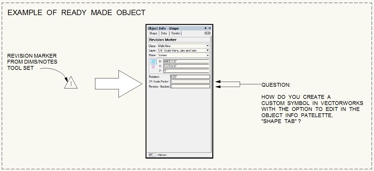
7 hours ago, Pat Stanford said:
Parameter records from a Vectorscript (or Python) PIO can also be reported and edited in a worksheet.
Indeed one can, shame if not from M objects.
However, my point was that if the needs can be met using the built-in functionality, one should not create a PIO. I believe that most users do not know how to create database driven tags in symbols. The simple solution to the issue at hand would be that the Object Info would remain in Data tab mode, either as default (ie. in the last explicitly selected mode) or via an option. The report is a workaround of sorts, but not unproblematic, of course.
One of the problems with parametric objects that the programmer can very easily get the serious disease called featuritis and a small and simple scripting job, which produced a working tool as a matter of hours, becomes a project taking weeks. In the case at hand, there might be a need to use a user-defined symbol as the graphic, add a leader line of a certain style and so on. An ideal door tag would be associated with the door in question and be able to query & display its parameters. (Did I mention featuritis?)
-
 2
2
-
-
13 hours ago, Naos said:
 13 hours ago, Naos said:
If you need to edit only the tag text perhaps a symbol with text linked to a record field would do, but I agree that going to the data tab is clumsy. However, one can edit the data in a report, which has advantages as comes to systematising and normalising data.
-
1
-
-
Modified in what respect?
Unfortunately there are few learning resources, but you should have a look at the examples here http://www.vectorworks.net/support/custom/vscript/example
Also you might ask the same in the Marionette section. People using M may be more forthcoming and helpful than Vectorscripters and I understand that there are learning resources for M.
-
1
-
-
3 hours ago, _c_ said:
I attached one set for you to use, that includes ALL hidden functions that I could find, also stuff really buried in the resources. Look at the zipped file attached to my post.
Well, excellent! You've done what one should get from the developer VS site, that should of course include also those hidden functions that cannot be found even by the Grand Master of Vectorscripting. Hats off, lads: if Ms. _c_ does not know something about VS, it is well and truly unknowable.
-
2
-
-
26 minutes ago, _c_ said:
create a simple list of VS keywords
A tall order: one has to go through the library file MiniPascal Callbacks (or something like that), which incidentally has at least in the past contained functions that are not in the official documentation.
Nice method, though, thank you.
-
OK, did not know that. Well, the reduced functionality should me more than enough.
-
12 hours ago, David L said:
I tried copying the script into TextEdit
The best editor for VectorScript is in my opinion TextWrangler, there Is even a language module http://www.vectorlab.info/index.php?title=Category:Language_modules that knows most of VectorScript's functions (whether it has been updated in the last years, I don't know) and shows them in colour. UTF-8 can be set as default.
-
10 hours ago, Kevin McShannon said:
the printer driver also would not work on it.
What, no driver for the current OS X? That's really bad customer support, but then again, it is HP.
-
28 minutes ago, Urbanist said:
A professionally useful space object would of course name itself automatically, but unfortunately there are no people with actual experience in real projects involved in the development of VW and its components.
Forgot to mention that, AFAIK, the LOC criterion looks at all layers and needs another criterion (eg layer) to work reliably. Say, a loose furniture schedule in a multi-storey building can get quite tricky, but I believe there is a solution: Hippocode's Symbol Object can obviously associate itself with the spaces containing it. Whether it allows reporting by space (instead of a query for each space which gets rather cumbersome with even 100 or so spaces), I don't know. Wouter will tell you! He has actually done real work and seems to know what is needed.
http://www.hippocode.com/extensio
-
8 hours ago, JMR said:
One just needs to give the space an individual name, which can be same as the room number.
A professionally useful space object would of course name itself automatically, but unfortunately there are no people with actual experience in real projects involved in the development of VW and its components.
-
12 hours ago, Art V said:
There is a lot of free software that is lacking but there is also quite a bit of free software that works quite well, PostgreSQL and e.g LibreOffice are two of them that are well known,
For unfortunate reasons that are irrelevant in this context I've used LibreOffice for roughly a year now and if that is good free software, I don't want to have anything to do with that of lesser quality. If I'd need to do some real work with LibreOffice, I'd start to hate computers even more than I do now. Simply shocking in every respect!
Your point about allowing collaboration by people of lesser means is, however, most relevant.
-
1 hour ago, Art V said:
Based on what I have read, but have yet to get into PostGIS, databases like PostGIS can have multiple records for a single object provided the object has a unique ID. The GIS software may only be able to use one record at a time unless you do a table join to merge multiple records, but it should be possible to change the record linked to the object without destroying data. Unless that information is incorrect.
Interesting, good to know.
However, SQL is definitely not my forte (IMHO, SQL is set theory made difficult) and it seems that PostGIS works only with PostgreSQL; also I am somewhat suspicious as comes to free and open-source software. Free is often exactly worth the price.
-
On 10/1/2017 at 9:10 PM, JMR said:
I agree!
Door tag is a very important, fundamental tool for an architect!
The local standard over here is to show the following information in the door tag:
In my country pretty much the same so VW's door object is totally useless as are most of the objects. I wonder why any architect would buy VW here and actually almost no-one does.
-
8 hours ago, Hippocode said:
I have no knowledge about that GIS object. Why can you only add one record ? Seems strange
")
When you put up your hand, I knew you would crack it! '
In the GIS programs I know, only one record (ie. alphanumeric component of the geometric object) is possible. A GIS program typically stores the data in files, one for the geometry, another for alphanumeric data. The latter can be either of a proprietary type or generic, such as DBF.
I once wrote a MapInfo export facility for a client's very specific use of VectorWorks. There was a published interchange format (MID/MIF) in which the geometry description was not entirely unlike than that used by VectorScript, but it was quite a challenge anyway. Actually the graphic representation (only symbols in VW) was simplified to be extremely symbolic (a rectangle for each symbol) because the very large number of items and the intended thematic mapping of the items. The system had to be very easy to use (the client was not in design business and VW users had little skills) and absolutely reliable as the MapInfo part was an integral part of their business planning. Shamefully, in this project I profited from gambling: the rectangles were poker machines and the purpose of thematic mapping was to maximise their performance by analysing the impact of location in the premises.
I also wrote an import script, but getting that to be generic in the alphanumeric side was too difficult. I then used ad hoc -variations of the script to import clients' MapInfo data, which was extremely useful in our urban design practice.
-
4 hours ago, ABi said:
Hi there,
What is the best way to apply tiles on wall? Make a renderworks texture and apply it on the wall? I mean if I do that, then tiles will be all over wall (and I would like to have tiles only in bathroom). Or should I make a plane, extrude it, and then apply it ( attached print screen ).
I would appreciate your help. And if you had any good links to tutorials, please share with me.
Thanks a lot for help, good guys!
Alice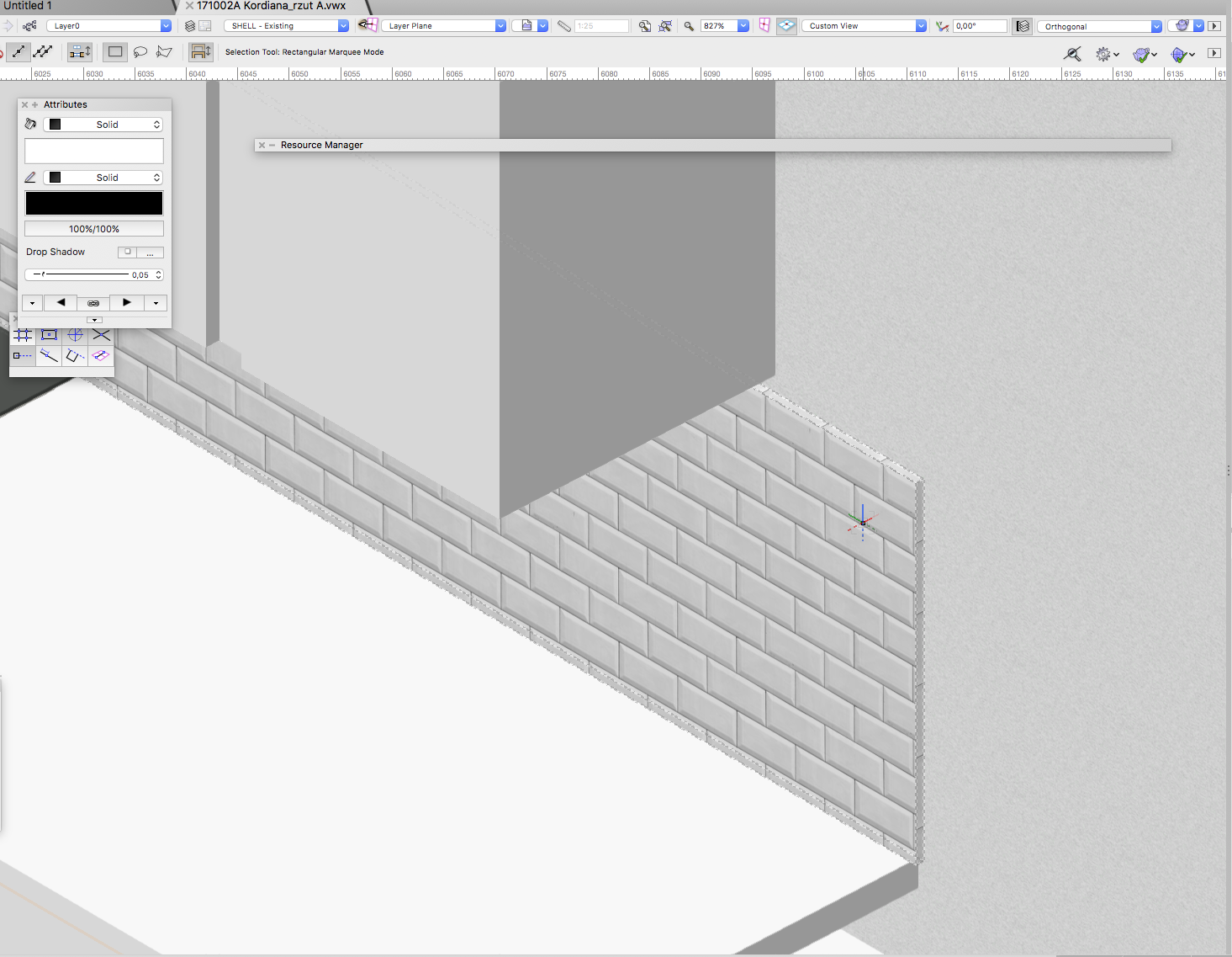 4 hours ago, ABi said:
Hi there,
What is the best way to apply tiles on wall?It really depends: if you need dimensional accuracy for working drawings, you may need to create each tile; ie. model one tile and then make a rectangular array, finally cut tiles at corners and ceiling with solid subtractions. Grouting as a thin wall. For pure visualisation, a thin wall (tile thickness) and texture should do the job.
-
3 hours ago, Matt Panzer said:
Have you tried using Data Visualization in a viewport?
Excellent!
I noticed the feature when it was introduced and made some small thematic mapping tests. Not quite what real GIS-programs do, but not bad either. It certainly did not occur to me that it can be extended like this, it opens entirely new possibilities. Pity I no longer do any real work. Well, retirement has its advantages, too: at least one does not have to deal with clients.
Now, where do I keep the stupid dongle nowadays? I really must see what & how you've done!
estimating Hours
in General Discussion
Posted
If you are not really desperate for work, let the other architect take the responsibility of the existing conditions model, unless the client is willing to pay the real cost, in which case a reasonable hourly rate would be the only sensible way. Also, laser scanning might be necessary, I've not tried the point cloud functionality of VW, it may or may not work (my guess is the latter) , but the survey company should be able to provide a 3D-model as polygons.