
lisagravy
-
Posts
203 -
Joined
-
Last visited
Content Type
Profiles
Forums
Events
Articles
Marionette
Store
Everything posted by lisagravy
-

How-to: import GIS Data (KML / SHP) into Vectorworks Spotlight
lisagravy replied to mjm's topic in General Discussion
@Lisar You can do this really easily using QGIS software, which is free / open source. I don't think you can import KML directly into Vectorworks yet. -
Yep, so as @iainlyon pointed out, my obvious mistake is in the 'site model layer' setting - my site model is on a different layer, though is set to accept modifiers from all layers. I didn't realise it defaulted here to <landscape area layer>!!
-
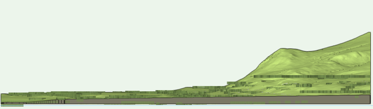
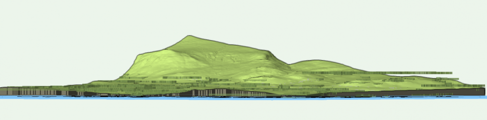
@Tony Kostreski I did also try just importing your Forestry Line style and using that... but my landscape areas are still not hugging the terrain weirdly, you can see in the elevations they are projecting out at flat lines from the highest point on the site model that they touch?

-
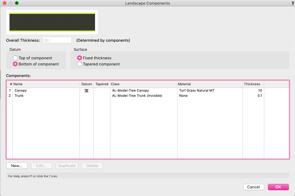
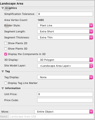
Hmmm I seem to be falling at the first hurdle here, and not sure why! I've set up landscape areas to display 3D components / 3D polygon, and sent these to surface on my site model (though I don't even think I should have to do that?!) and my polygon is still weirdly floating in air away above my site. @Tony Kostreski - I'm assuming I'm missing something insanely obvious, but I can't for the life of me work out what I'm doing wrong here, before I even get to mesh stage!! I've screengrabbed some of my settings below.

-
Thanks for the suggestions guys! At least I have an idea of where I might be able to start now, I'm going to have a bit of an explore on these today / over the weekend to see what best fits... and I'll come back to you with where I end up with!! @Tony Kostreski - thanks so much for checking this out. This looks near enough like what I'm looking to do - particularly the scuptural mesh, and I'd have never got there without your post. At a site this size, it is really just for visual context purposes, but I felt a single defined height wouldn't really give the right context! So being able to sculpt it slightly looks like it could work. Also may have a look at bump maps @jeff prince - I've never used them in Vectorworks, did have a short foray into 3DS max years ago and thought they were great though. Could possibly use a combination! @unearthed It is only for presentation really, though I'd like the positions to be accurate - I have fairly accurate map polygon data, albeit in 2D. I could access LIDAR but there is a pretty steep charge here and it's not something our project will budget unfortunately! It'll be for overall views of the site area, and possibly a couple of vignettes - the project really is about what's happening between the forestry banks - routes, facilities, biking, etc, but it's all set within forestry clearings so it's important to get something that isn't clunky, but also doesn't look just like an extruded block! I'll have a read through the links, it does sound similar to Tony's, though if I can streamline anything by a bit of QGIS work that works for me!! Will let you all know where it goes!
-
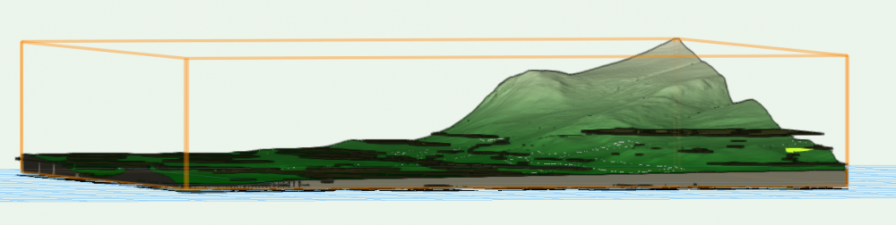
I have a site model of around 5km x 4km... within which there is a fair bit of forestry cover. I don't have (and won't have) tree survey information for this entire area... however I have polygon blocks showing the extent of significant areas of forest. I know I could use landscape areas to show a block of planting at set height, but I'm conscious of site area and killing my machine! And I know I could look at extruding these blocks from the surface of the model to a set height to give sharp massing blocks... but I'm looking to create something a bit more stylised, and softer in terms of edge and height. I'd ideally want to show a mass with transparency and texture, and potentially undulating height (say between X and X metres above site model surface) - almost like being able to put a drape or blanket over the trees!! However - I have no idea where to start with this, or if it is at all possible. Has anyone shown forestry successfully graphically in Vectorworks in this type of way? Or does anyone know of a tool I could look into to give this type of visual effect?
-
Hi Tamsin, Thanks for this. Our IT folks actually advised us to keep Files on Demand switched on... so we don't have to locally download our entire server! But it looks like we can specifically choose to 'always keep this on device' for Vectorworks Project Files if we need to. Regardless, even without doing that the issue seems to have righted itself today! 🤷🏻♀️
-
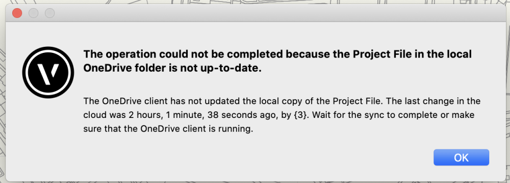
A couple of us (myself and @mocha) are having issues with Project Sharing this morning - we are getting the below message when trying to save & commit. OneDrive is signed in, and the Project File is up to date... the last saved change was 2 hours, 1 minute, 38 seconds ago! Not sure how to fix this. We are both working on new machines today, so I feel like we're missing something obvious...
-
@Tom W. Is the geo-referenced geometry you're trying to import from another Vectorworks file? If so, that file needs to have the same geo-referencing settings, and particularly the exact same internal origin position as your current file. Also, if you click 'edit properties after creation' when you create your import layer, you can make sure the import layer is also set to be geo-referenced. I have to admit I had to have a look at this method of import, as I've never actually used this workflow - usually I'm either importing from DWG, where I use File > Import... or I'm using Design Layer References (Draw Rectangle > View > Create Viewport > Select Source > External Document) to reference information in other Vectorworks files, without fully importing all the geometry. It sounds like somewhere your import alignment is set to 'align with user origin' - but there doesn't seem to be the option that I can see to correct this via this import method. (You can however change the import alignment when importing from DWG.)
-
Pivot summary imported fine! 😊
-
@Pat Stanford Thanks! I can sort A>Z in Excel, just can't summarise unfortunately. @Tamsin Slatter Thanks for the link! I'll give it a go 🙈 My brother's an accountant so I'll maybe see if he'll do it for me for the price of a beer!
-
@Pat Stanford I don't think I can do it in excel either, though I'm not an excel whizz and I maybe could with some research! A quick google tells me I need to learn PIVOT tables, which look awful 😂 I have 200+ entries / rows, where one of the columns is text responses to a consultation. Many of the text responses are the same, so I'd like to summarise the duplicates, so that on the drawing I just get each response once. I've done this before with the database function lots and it's really helpful.
-
Is there a way to summarise items / sort items in a worksheet in which the data is imported from an excel spreadsheet, rather than created from the drawing as a database? When I'm trying this, the sort / summarise / sum items all appear to be greyed out.
-
We're working in EPSG 27700, and have a drawing with plenty of content already created. I need to send some of this information out, ideally in EPSG 4326. I have tried to just change the EPSG in the existing document properties... which seems to perform a transformation of my geometry depending on the options for transformation I have selected. However, when I export (for example, an image file with associated georeferencing file,) the export still references EPSG 27700 co-ordinates. Am I doing something wrong here? Does Vectorworks perform georeferencing re-projections like this? (And if so, what's the right workflow?) If not, I can work this out in GIS - I just thought it might be neater to do directly!
-
- 1
-

-
- gis
- georeferencing
- (and 3 more)
-
Keynotes - more data please?
lisagravy replied to lisagravy's question in Wishlist - Feature and Content Requests
@shorter - this could work - we could manage a database library of callouts and associated information separately to be read by Vwks, and I can see the benefit intros. Ideally I'd then want to select my callouts in Vwks from information from that library - and then be able to export a worksheet showing the full data including associated information from the original excel library, but only for those callout items used in the drawing. -
Keynotes - more data please?
lisagravy replied to lisagravy's question in Wishlist - Feature and Content Requests
I think this is kind of what I’m trying to do? I’m looking to work our detail drawing annotations into a spreadsheet specification which gives additional detail on each item. I thought the callout option would be good as, like you say, the details themselves are 2D lines & hatches, (so are not BIM objects / Chorus tagged with data,) but with the callout / keynotes library you can easily select pre-determined data in the form of a description / note for each item from the database. My wishlist item is just noting that it would be great if we could incorporate additional data which would save alongside the item description, as a separate (but linked) record. So that when you annotate something as amenity grass, there is another field for additional data, into which we can save specification notes such as preferred seed mix, soil depth, etc. Then, if we export a worksheet of all the keynote information, we’d have a detailed specification for all the items in the drawing, directly linked to and generated from the detail annotations, but with more information. It’s less useful if I need to add in the additional specification each time, there’s no real benefit to doing that in Vectorworks if so - I could do that in excel / somewhere else. The real benefit would be labelling a detail ‘amenity grass’, and Vectorworks pulling pre-saved amenity grass specification information into a worksheet, to save me re-typing it! So I’d ideally thought if we could utilise the keynote database for the additional data, we could store specification info for each item here in a library, so that we don’t need to rewrite or re-input the specification for standard items each time, or maintain a current library of specifications. I’ll do some experimenting with creating callouts as a symbol. Still would like to keep additional data in the Callouts database as a wishlist item for future though! This would be a really excellent feature. -
Keynotes - more data please?
lisagravy replied to lisagravy's question in Wishlist - Feature and Content Requests
Thanks @Boh - I know there are probably good workarounds, like potentially symbols - and I will have a look at data tag! I just thought this keynote callout feature with the database seems so so good, adding in the functionality of an extra, non visible associated data block is really high up on my current wishlist!! -
Keynotes - more data please?
lisagravy replied to lisagravy's question in Wishlist - Feature and Content Requests
Thanks @Boh and @ericjhberg - Does this have to be done for each individual drawing though, and the custom data inputted each time? Or can this be linked to the callouts database, which could be used again and again by multiple users? What I actually want is for custom fields within the notes database to store additional information associated with each individual note, which doesn't have to be displayed in the key. For example: I might have a saved note for a 'root barrier membrane'. I set my call-out to label as 1, and key note would be "1 - Root barrier membrane". This is saved within a communal callouts database. I don't want the key on my drawing to show the supplier, dimensions, or any additional specification information on the root barrier membrane, as I don't want my drawing to be cluttered with this information - but I do want to store / link these within the note saved in the database, so that for each drawing, as well as using the database to generate a simple key, I can also export a worksheet of all the supplementary information not necessarily shown in the key? Without having to re-input the additional data each time? I understand I can attach a record to each call-out, but if I understand correctly, I'd likely need to re-do this for every call-out and every drawing. So that's kind of what I meant by setting up additional non-linked records? It loses the database / library functionality. -
Sharepoint and Project Sharing
lisagravy replied to lisagravy's topic in 3rd Party Services, Products and Events
Thanks @Tamsin Slatter, Domas is helping us out!! -
I have just been introduced to keynotes. I love these - loads of potential!! However - in addition to the description (which is essentially a title?) and note text (which appears on the key on the drawing,) please can we add additional data? Like a record type setup? For example, I want to be able to set up a drawing with keynote callout numbers, and an associated key with a note / summary of each item, which I can do at the moment using the notes database. I then want to be able to set up a worksheet showing these numbers and note text, but also another data column (or series of columns if needed) showing further detailed data linked to each of the items in my key - for further specification reference. I don't think this is possible right now aside from setting up additional non-linked records... but it seems like a straightforward(ish?!) addition to the current keynote function, and would be AMAZING for us in terms of functionality.
-
Sharepoint and Project Sharing
lisagravy replied to lisagravy's topic in 3rd Party Services, Products and Events
Thanks @Tamsin Slatter - we're still getting used to it! It's actually OneDrive we're using, though confusingly referring to it as Sharepoint, as when we click on OneDrive the web address then references Sharepoint for some unhelpful reason... (I really dislike Microsoft!) So as far as I'm aware it should be compatible / supported. We're sharing the folder among users, and working files stored on each desktop. I'm not sure if it's a project sharing issue or one drive issue. It is working - but takes loads of syncing and communicating between users which I didn't think we'd need as much of! -
Is anyone using Sharepoint and Project Sharing successfully? We are experimenting with Project Sharing, which looks fantastic - but trying to do this remotely with master files saved on Sharepoint for multiple access. We seem to be having issues with syncing - and I'm not sure if this is due to Project Sharing, or Sharepoint, or a general incompatibility between the two. (Working on a master file, committing changes and releasing, but then the master on sharepoint not updating.) Any insight or experience would be much appreciated.
-
Thanks @Mark Mullany - I had looked at this, but I'm not looking for anything this comprehensive - there will be an Engineer on the project who's scope will include working out the accurate tracking, so it's not something we'd pay a subscription for. It's just we used the free Vectorworks tool before successfully to anticipate and sense check our allowance for driving curves within the initial design, prior to these going to the Engineer for review. Does this not work anymore?
-
@Tamsin Slatter Thanks! Much appreciated 😊
-
We've noticed in Landmark there is this option under Landmark > Existing Trees > Import Tree Survey File. We love the existing tree tool, and are experimenting with different ways to use this - particularly in our experiments with the new data visualisation feature. However, at the moment we are creating all the existing trees from the tree survey manually. It would be AMAZING if we could import a tree survey file and for Vectorworks to translate this into existing tree objects. Is that what this tool does? Has anyone used it? Is there a guide as to how to do this? Is there a specific format we need to be asking for our tree surveys in? We're very excited that this tool seems to exist, but we can't find any info on it and don't know where to start 😂