
lisagravy
-
Posts
203 -
Joined
-
Last visited
Content Type
Profiles
Forums
Events
Articles
Marionette
Store
Everything posted by lisagravy
-
Has anyone else had issues with the Driving Curve Tool plugin since 2020 upgrade? I had to re-install mine, and when I draw a path using the tool nothing happens. Not sure if I'm missing something obvious or if this is a bug related to one of the recent SP upgrades. (I did have it working fine previously, though this was some months ago!)
-

Massing Model - Pitched Roof Options
lisagravy replied to lisagravy's question in Wishlist - Feature and Content Requests
Thanks Tamsin. If all the building floorplans are slightly different, (which they irritatingly are,) I need to do a custom profile for each one anyway? So really I just want a tickbox option alongside "pitched" that creates a gable-style roof to fit each of the building sizes / outlines - if possible! The way the pitch option does. I will hold off on the shooting for now! 😂 -
Massing Model - Pitched Roof Options
lisagravy replied to lisagravy's question in Wishlist - Feature and Content Requests
Take it there's not a quick way to do this yet? Currently working through 172 buildings to change each roof profile to pitched, and it's making me want to shoot myself... -
@Cara2 In 'landscape area settings' make sure the 3D display is set to texture bed or 3d plants and not 2d only? And in the class, go to textures and make sure there is a texture set! Those were the issues I had I think from memory.
-
We received some 'Enscape 3D' links from a consultant we're working with this week. These provide interactive 360 degree navigable views from a set point on their model which open via weblink, so would be something we could send to clients etc without them having any modelling or visualisation software - and looks to me like a plugin which works with Revit / ArchiCAD. Is there anything comparable at the moment for Vectorworks, or is this something that could be incorporated within Vectorworks itself? Thanks, Lisa
-
This is what I need. I asked the question in the forum and apparently the aligned hardscape tool is a good start?
-
...Apart from, it crashes anytime I try to add a modifier. Do I have to 'edit surface modifiers' within the hardscape itself, or can I use a standard stake modifier on top of the hardscape? It seems to be that editing surface modifiers is crashing all the time. Sometimes a site modifier stake seems to work on top, and sometimes it doesn't. Anyone used this successfully and have any tips?
-
https://app-help.vectorworks.net/2017/eng/VW2017_Guide/Import/Importing_Georeferenced_Images.htm states that: "GeoTiff image files can be imported, but no georeferencing information within the file is used." Can we add functionality for importing GeoTiff image files with their georeferenced information (scale & location) included please? OS Vectormap Local and Vectormap District both don't have world files associated and would be good to be able to use.
-
@bgoff Thanks! Aligned slab is exactly what I need.
-
Ha, amazing! Glad it worked, it was really annoying me! Have a good one too.
-
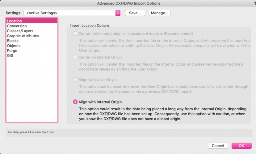
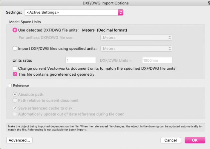
@adam covell - last thing I've thought to check, just incase this is a difference between between Landmark / Architect? On import, if you click advanced at the bottom left? It gives you options for import location. The standard default for me is the top option (centre first import, align all subsequent). If you imported like this your drawing would centre on the aerial for Greenwich Park. However, with the "this file contains georeferenced geometry" box ticked, my VW then only gives the bottom option as available - Align with internal origin. Maybe just make sure yours does the same?
-
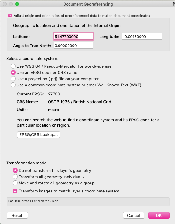
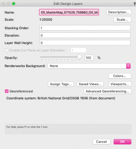
@adam covell Ok. So I've done the same thing with a blank file just to check I'm not missing anything, and mine is working.... here are my steps. Blank document. Check the georeferencing settings are on (File > Document Settings > Georeferencing) - they should be on by default. Origin > User Origin > set user to match the georeferencing system. Check the design layer settings to make sure the layer is also ticked as georeferenced? (This shouldn't matter if you're ticking the georeferenced box on import as above, but worth doing in advance if you're having issues just incase! All new layers have to be set to this too.) Import DWG with "This file contains georeferenced geometry" ticked. (Units should be in metres.) You should on import get a blank screen centred on the INTERNAL origin, (blue crosshair thing,) which will still be at Greenwich Park in GIS terms, and you should have to fit view to objects to locate your imported information, which will be situated somewhere away from the internal origin. You can check the geo image at this point and it should match your imported information - mine does. Then, click Geolocate, and click a position on your site. All this does is move the internal origin from Greenwich Park to your site, but shouldn't affect the geo image if you try this again. It will move the user origin again though, so you should go to Origin > User Origin > Set user origin to match the georeferencing system again for completeness.

-
No worries @adam covell . Yes your drawing is in the wrong place unfortunately - it is in Germany. The user origin doesn't affect the position of the drawing in GIS terms, but rather just whether what you see on the rulers is correct / makes sense. If you open a blank file, set the user origin to match the georeferencing settings, and re-import the OS dwg - but make sure you tick the 'this file contains georeferenced geometry' box on import. This should import it in the correct place, on both the rulers and the geo image. (Note that if you then use geolocate to position the internal origin on your site (which you should do), you'll have to reset the user origin again to get it to match the easting and northing co-ordinates again. It won't affect your positioning though.)
-
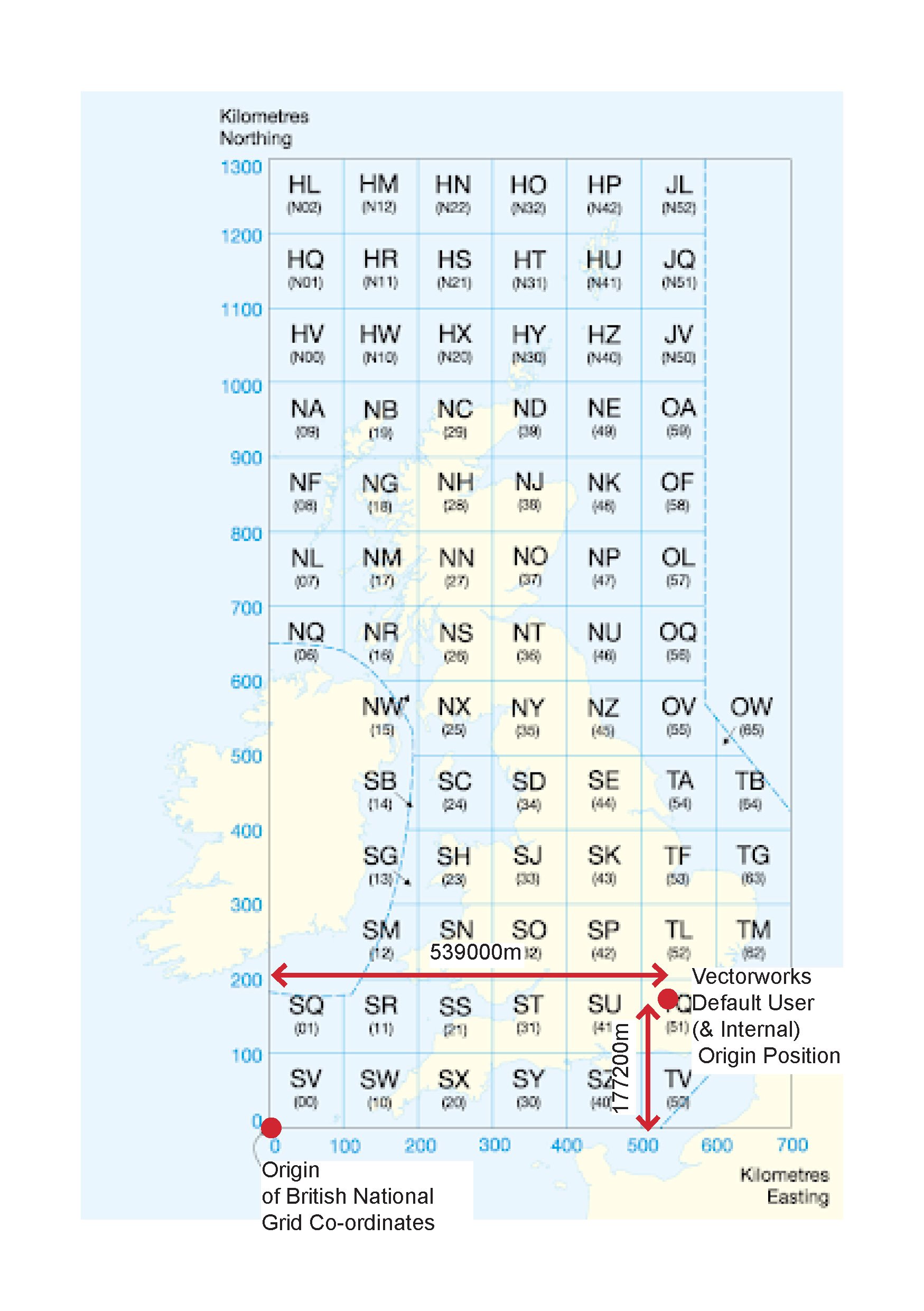
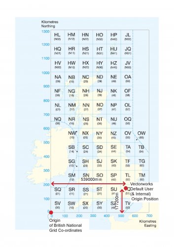
@adam covell I think this is because your user origin and GIS settings don't tie up. An easy way to check is to go to Tools > Origin > User Origin, and select "Set User Origin to match the Georeferencing Co-ordinate system". This will change the document grid to match the georeferencing co-ordinates and show that the grid of your drawing is actually in an incorrect location in geo-referenced terms? The reason for this is that British Grid is set up using an agreed origin point off the coast of the Scilly Isles, and all co-ordinates are measured by Easting and Northing distance from that point. Vectorworks origin (both Internal and User) default to a location in Greenwich Park - so you want to reset your ruler to the actual British Grid 0,0 point, otherwise your drawing will sit geographically approx 539000m east and 177200m north of where you think it is.
-
I've created a hardscape by boundary, due to varying width and form - though the hardscape is essentially intended to be a path, and I need to treat it as such in terms of levels. I know using the roadway / pathway settings you can edit each point on the path to set the level and crossfall... is there a way to do this with a boundary hardscape? Essentially I want to be able to input the edge levels along the route in 3D, and then potentially make this a modifier for my site model. Is the workflow for this to edit a base site model, placing stakes at the required chainages, and then set the hardscape as a texture bed only? I'd ideally like to set the levels within the hardscape itself, and keen to use the slab settings within the hardscape to allow detail sections. Any help much appreciated.
-
Massing Model - Pitched Roof Options
lisagravy replied to lisagravy's question in Wishlist - Feature and Content Requests
@ScottLebsack Thanks - I'm one of the posters in that thread 😂 It is possible - but arduous if you have lots of buildings (i.e. a new village) all with slightly different floorplans, compared to just the tick box on the massing model tool which would be a great help. -
Any ideas for a workaround for copy / paste in place between files? All I can think of is to copy with a reference point and then manually re-position.
-
Massing Model - Pitched Roof Options
lisagravy posted a question in Wishlist - Feature and Content Requests
I love the massing model - but we typically need to show buildings with a gable pitch rather than hipped? Right now I know I can edit bespoke, but in terms of a wishlist item it would be good if there was scope to have this roof option factored in as a tickbox or something please?
-
😂 Thanks @Tamsin Slatter really appreciate it!
-
See attached test file if anyone wants to take a look at what I mean? Try to copy / paste in place the rectangle from one layer to the other and check the positioning.... TEST FILE.vwx
-
As a follow on from my numerous posts about Georeferencing Settings - I thought I'd cracked this and rolled out a workflow, but am now having some pretty fundamental issues in my files which I need to resolve ASAP! Any help much appreciated. I have a master file with document georeferencing switched on (British National Grid), and all layers set as georeferenced. All my xref files have the same internal origin (close to the site) and user origin set to align with georeferencing system. The geo image aligns perfectly with the site. All seems well. However. When I copy and paste in place the same object from one layer to another within the same drawing file - both layers having been georeferenced to the same georeferencing system in the same document - the position of the object shifts? It's very slight and barely noticeable, but measures around 19mm of a difference in position of the same object copy / paste in placed between the two layers. This is a huge issue for us - but I'm not sure if it's an issue with functionality, or just our workflow? Any help or advice gratefully received.
-
@Mark Aceto I think you'll need to convert your .gdb first - I might be wrong but not sure that will import to Vectorworks directly. You want to convert to .shp. Looks like you can do this from open source QGIS software https://gis.stackexchange.com/questions/304780/converting-gdb-files-to-shapefiles-for-autocad or there may be some online converters you can use. Then if you make sure your georeferencing settings in Vectorworks (File > Document Settings > Georeferencing) has the correct CRS selected (from your data it looks like you want to be using WGS_1984_Web_Mercator_Auxiliary_Sphere) when you import the shapefile it should be in the correct geographic location... so you shouldn't need to move geo-image? I think the idea is that if your geo-referencing settings are correct, you can't move the geo-image, as the image shows the aerial photography of the geographic location in vectorworks... if it doesn't match with where your drawing is, your drawing isn't located correctly or your settings are off somewhere.
-
New Layers: Georeferencing on by default?
lisagravy replied to lisagravy's question in Wishlist - Feature and Content Requests
Yeah I think so? I understand a lot of people maybe wouldn't use it, but seems odd to set the file to automatically geo-reference, without the layers doing the same? At the moment, even without turning the georeferencing layer settings on, the file is georeferenced by default. So for anyone not working in a georeferenced environment, with the georeferencing for each of the layers turned off, it's then difficult to import or export occasional GIS information, because VW assumes your drawing, (centred on the internal origin,) to be in Greenwich Park geographically, and imports / exports the shapefiles geographically? (This is actually how we first came across georeferencing in VW 2020, as we had issues with alignment between the two where we never did before!) It just seems to make sense to either have both settings off by default or on by default? Or yes, definitely to be able to have the option to choose on a file by file basis what the default is. (I'm just not really sure of the workflow that benefits from the file default being on while the layer default is off?) -
New Layers: Georeferencing on by default?
lisagravy posted a question in Wishlist - Feature and Content Requests
Small request, but would it be possible to set the default for new design layers to be for the georeferencing to be switched on please? Even if it's on a file specific basis, so you can select that all new layers in a particular file will be set to georeferenced? At the moment the file is automatically geo-referenced, but the layers are default not, and everytime a new layer is created the setting has to be manually turned on. -
Yep you're bang on, it would be for LVIA. We've tried it before with variable results... but to be fair without the camera 'effects' switched on! Any advice from the engineering friends would be much appreciated.