
unearthed
-
Posts
553 -
Joined
-
Last visited
Content Type
Profiles
Forums
Events
Articles
Marionette
Store
Everything posted by unearthed
-
Tedious as it sounds I often make an image of the page image contents ie all visual raster content and just have my vector linework in a viewport as an overlay - but I don't do renderworks / digital rendering so I can do this without affecting my output style. I've been a VW user since '04 and do think it can produce small files but I think the strength is in the name: it's Vectorworks, not rasterworks or allthingsworks, it does do vectors very well (as long as you only use hatches and stipples cautiously). Anything raster (or huge spatially) I do in QGIS or an image editor. My main large file issie is where there's a raster image with content outside the viewport - as VW does not clip this it can make for huge files, so I tile large images and put each tile in its own class - or make an image of the sheet view and drop back onto sheet - VW could make a lot of this much more seamless but they just endlessly add nonsense bells and whistles - it's annoying. If VW is being a real pain I use pdf995 but I find with 2018 it's very good - I have a license upto 2022 but have no use for the extra capability so won't change until I do need that.
-
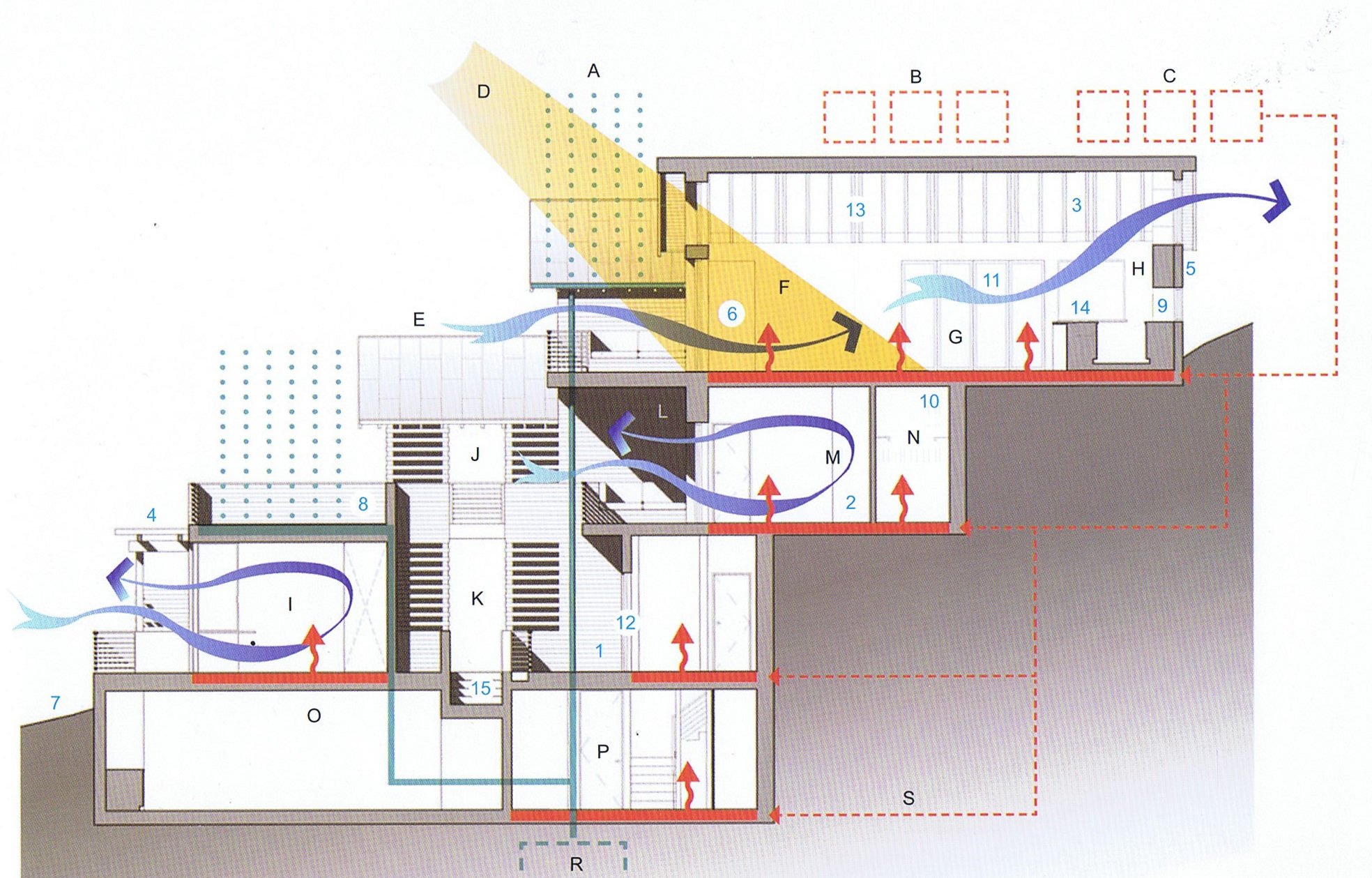
I've searched the forum and come up dry on this. I'm designing a poster which will have a 3D house model on natural irregular terrain and I want to show the flows of heat, dust, wind etc using arrows as in attached images. I realise these arrows are likely made as 2D in illustrator but am hoping for a 3D workflow. I can do this in sketchup but VW outputs look cleaner.


-
I just draw my VP in model space, select it and punch Alt v v [the action shortcut on my system] and accept or modify the items in the VP dialog when it pops up - including which sheet to drop it into - it is a bit basic though and there's little customisation, and @ least in 2018 no control where the end up, ie placement is manual.
-

Forum opening page view - how to not show pinned content?
unearthed replied to unearthed's question in Forum Feedback
Thanks Juan, I managed to declutter it a bit. -
Forum opening page view - how to not show pinned content?
unearthed posted a question in Forum Feedback
How do I hide / turn off the pinned contant?, I see it every time I visit, I know it exists, none of it is releveant to what I do so how do I make it go away? as I really just want to see questions and topics of which I can seen nothing without scrolling.
-
Why do Studios Create Saved Views for Sheet Layers?
unearthed replied to CW2020's topic in Architecture
To see a sheet at paper / print scale for the various printers I might print to. To maximise usuable screen space as VW has a lot of visual crap that reducing drawing space - Why oh why does VW not a have a fullscreen view?? To have a meta / info for me sheet that I don't want to send out - with some extra classes. -
My 2 cents for what it's worth. I almost entirely use VW as a 2D tool (except for some large earthworks models and some contour work), it does produce nice sharp graphics and with a little care small-ish .pdfs, and arguably the best tool to produce page layouts and it's having a built-in spreadsheet make it unique in CAD afaik - saving a lot of manual copying and errors (Rhino is getting closer though). I see that SS may be perceived as a problem, but no large modern company is going to be even remotely squeaky clean, it's the nature of late-stage Capitalism - Lobbyist Wars and the Development of BIM Medium article on VW history - no ethics there at all. imo stay with what is already working for you. Also look at threads about VW2024, that should be enough to make anyone pause.
-
Anything I only use in sheets is in its own class, this is my core set although any one drawing only ends up using about half of them. A
-
How to export a points file from vectorworks?
unearthed replied to unearthed's topic in General Discussion
Thanks Pat, I'll have a go on Monday, for the meantime I managed it another way as I found our NZ Survey agency has an online converter*, and that result if sufficient for what I'm doing. For any other New Zealanders using this tool you can paste long lists of coordinate pairs into the box and it works fine. -
Hi MichaelK, Would you be be able to save None Class Tricks back to version 2018 please.
-
How to export a points file from vectorworks?
unearthed replied to unearthed's topic in General Discussion
Hi Pat, Thanks, still not there. I now need to convert the X and Y coordinates to decimal degrees (so my GPS can ingest them) and wouldn't know where to start on that, I do not know if there is an option or way to export from VW. The writer of the 2001 VW xyz export script I posted above hasn't been here since 2003, but do you think it would be possible to modify that script so it exported in decmal degrees? As it's a seriously difficult problems doing that as far as I can tell. -
How to export a points file from vectorworks?
unearthed replied to unearthed's topic in General Discussion
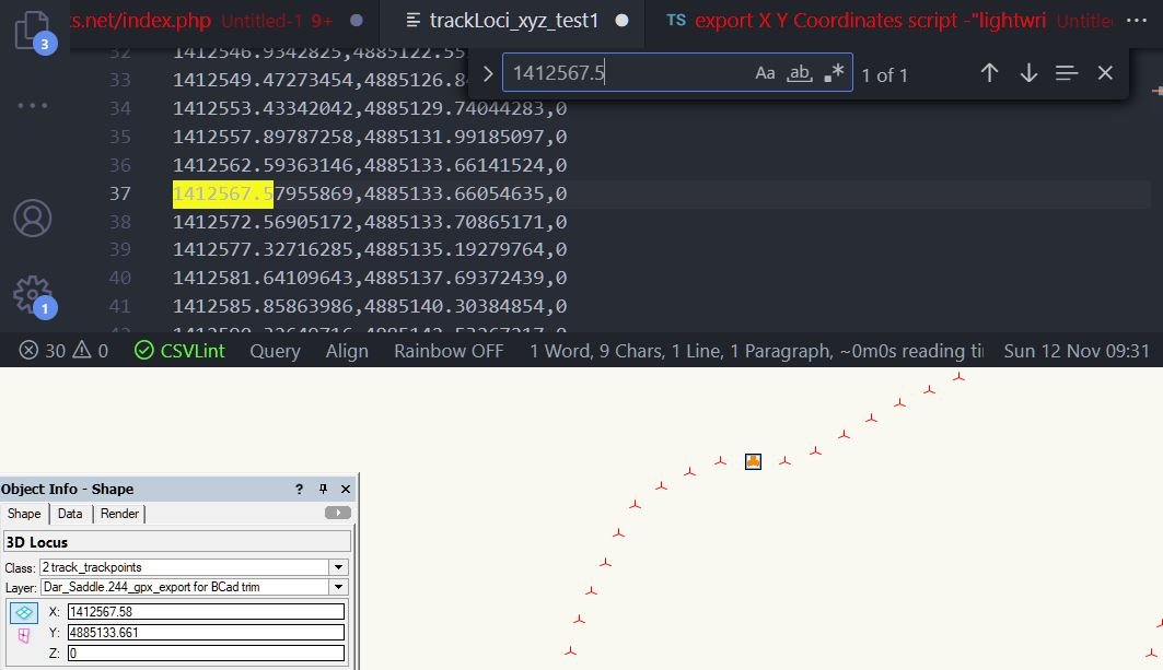
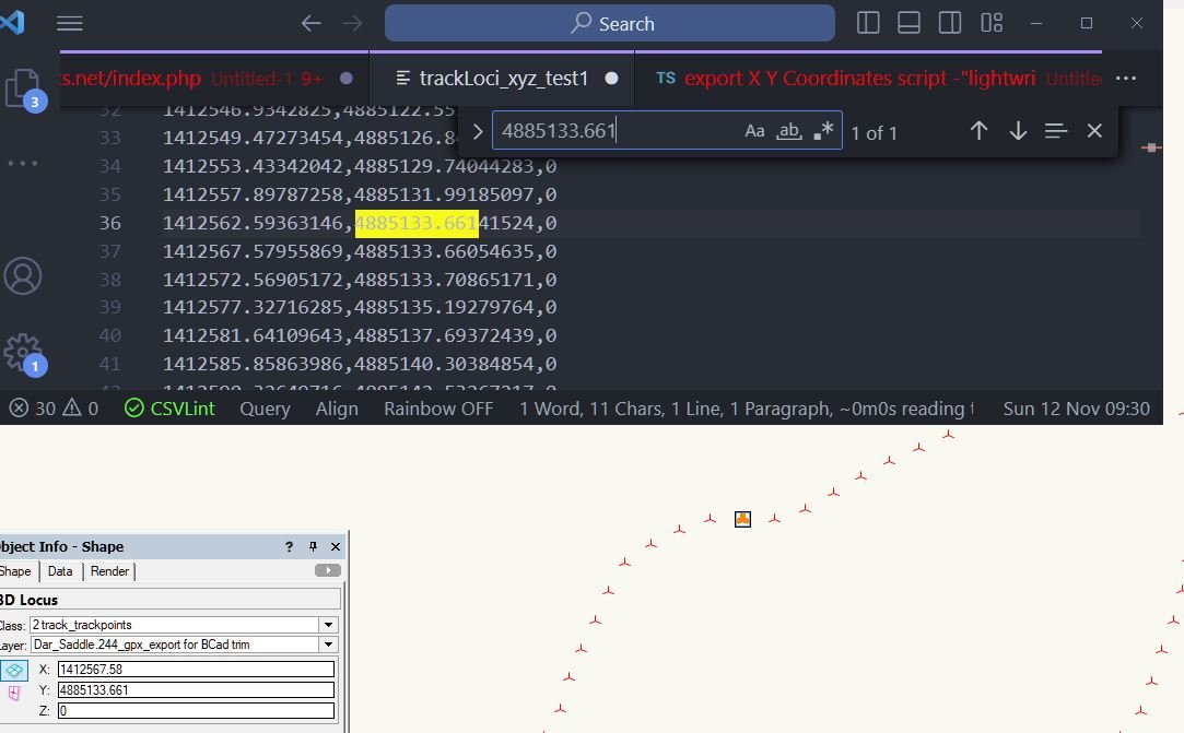
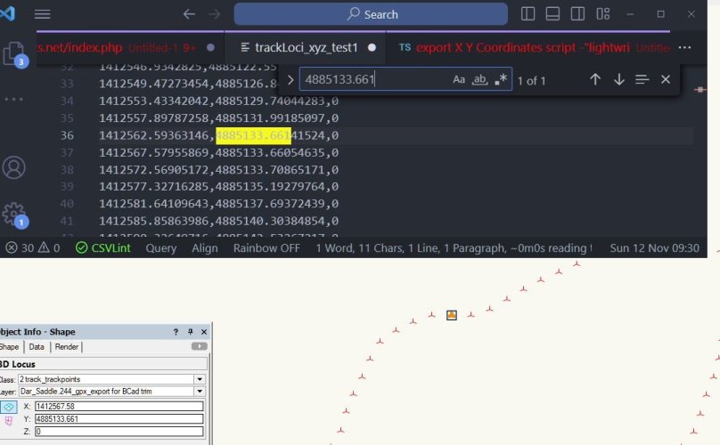
Thanks Pat, that led me to search: export X Y Coordinates script -"lightwright"site:.forum.vectorworks.net and I found this from 2001 and the second script seems to work well and corrects for the page orgin shift issues with 3D loci. And the two encl images looking showing position of the X Y pair are still correct after export. Interesting that the script un-rounds the number in the OI. I don't yet know if sort order matters. I've since made another set of points at 10m intervals as it simplifies visualy, and still dense enough for field work. Next I'll build the .gpx as per openstreetmap's page and see how it works.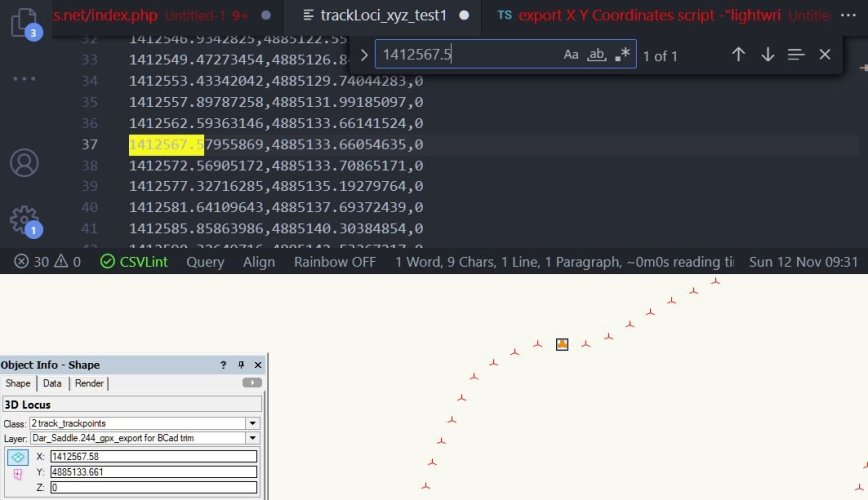
-
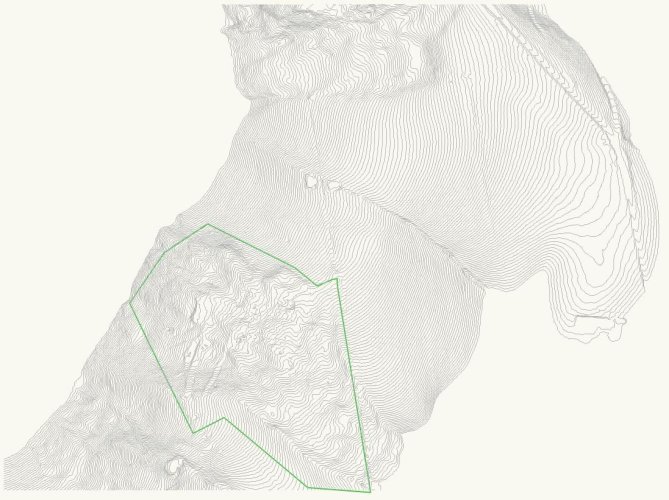
I have a set of 244 2D [encl. with bound box loci selected to highlight area], (3D is an option I have as well) locus points and a single closed 2D polygon - in its own class and the locus points likewise in their own class. I want to export the points as a cloud of x,y points in this format: 1378385.1650620073,4938850.9892900344 [and with a ,0 for the 3D version - I don't need heights for this] What I want to achieve is a txt / csv / tsv type file, with a list of x,y,z I can then hand build into a GPX file to import to my gps. The points are currently simply 2D (or 3D) loci, and do not have record info so I can’t export to .shp (which is a bit silly of Nemet as any GIS will import very simple files). Neither 2D or 3D loci export to .dxf. This is a lot of kerfuffle for what is one of the worlds most basic and essential spatial data formats. I tried exporting as script file and I got the loci but 258 instead of the 228 that I have in my drawing I've converted my field edge and bounding box to 3D loci so I can verify against georef space. If it matters the file is georeferenced to EPSG2193 (a standard New Zealand datum).

-
I found it works slightly better if switching to Ortho view but again fails after one run of the split tool. So gave up and did it in BricsCAD really easily, with zero failure instances. Something else I noticed using the split tool in VW was that the filesize kept growing (from 2.7mb to 5.5mb), whereas trimming in BricsCAD and reimporting that edited data took my filesize way back down again. Does VW not clean itself well after some operations? Lesson fir me is to do anything 'complicated' at least re topo data in QGIS or an ACAC-like platform.
-
I have an accurate contour data set but want to make it smaller for export to a GPS, so how do I consistently trim the polylines off outside the green polygon - the split tool seems to work on some lines but not others, it's a poor version of AutoCAD's fence tool that's for sure. I managed to trim 50 line in one go a couple of time but the tool seems to stop working /only work on singles. I can do this in QGIS but it'd be nice to save the roundabout trip. I don't want to build a model in VW as I want get contours back in the same place as they appear now. System is VW2018.
-
So, I take the resounding silence indicates no one is using VW CAD data to drive their GPS.
-
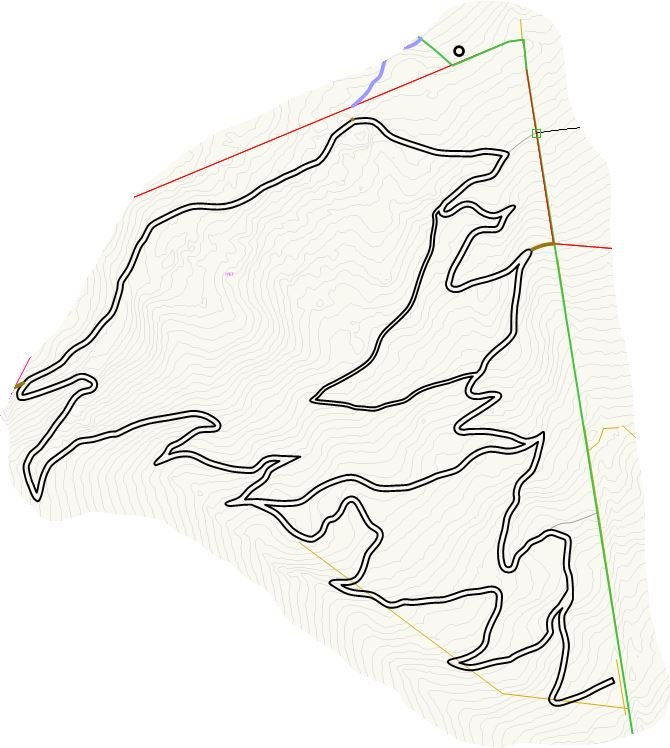
Before I reinvent the wheel I'm asking here to see if anyone else has got a workflows for exporting .gpx file. I want to use one from a drawing in my Garmin Etrex 32x to set out a walking path. I know there's a workflow to get one out of QGIS but want to know if VW offers a more straight-forward route for my very windy path - about 1200m: image encl. for anyone interested. openstreetmaps have kindly written up the gpx format, and I can build from scratch from a points export but hopefully there's a smoother way.
-
How to deal with large areas of meadow?
unearthed replied to Amanda McDermott's topic in Site Design
I normally just do a cirlcular gradient if I want just a basic grass-like representation, it is unfortunate that VW does not enable multi-node gradients. -
Questions to ask when receiving DWGs?
unearthed replied to Amanda McDermott's topic in General Discussion
I try and keep drawing data requasts short as possible as many people won't/don't read a long list! I always tell data senders what format I can work up to, e.g.: 'I can open .dwg / dxf formats up to version 2018' Certainly knowing what it came out of (& its version) is very useful, and telling them what you have (& its version). I have only seen one vwx file from another designer since 2010. Old (say ten years) vectorworks files can be a real mess ime, using one (the one above) at moment and would have been faster to redraw from survey and asbuilt heights. To cover the likelihood my request will get passed around the company I put in why I want a file eg: "This is related to XYZ audit that ABC have asked me to carry out." ALWAYS say the extent you want as s'times people send me just the house when I want the boundary. Ask if they have any levels / heights? Also if infrastructure is important ask about this, as many files leave it out ime as a landscape architect. Georef is poorly understood by almost everyone - and can overly complicate a request, I normally import into QGIS and sort that bit out and then into VW. -
I have a shortline on my chrome screen https://forum.vectorworks.net/index.php?forumId=55%2C14%2C20%2C12%2C48%2C16 just loads the content I want.
-
I have a desktop solution (see my comment upthread), but I would like to use AutoTurn but it needs to support all VW users, including older versions (or at least back to 2016), I probably have a vehicle situation about once a year, anything from cars to articulated trucks / B-Train system. As a service could be worthwhile but bot too many hundred of dollars. Many of us want to avoid subscription models. I often live remotely and need desktop tools for reliability.
-
Best Way to Get a Vector Graphic into Vectorworks?
unearthed replied to Robin Mair's topic in General Discussion
In the past I have used pstoedit, as well as online tools like cloudconvert - which is a LOT simpler than pstoedit unless you're okay with cmd line programs. Stupid and arrogant of VW to remove that funtionality - they don't seem to to understand we need and use a very wide range of file formats and tools to make our designs. -
Just upload a link to file and s'one will export it for you. Add the vectorworks version.
-
Thanks very much Pat!
-
When I got my 2018 upgrade I forgot there was an option to go up to 2022m currently on SP6. If I do the 2022 upgrade will it open my 2018 files? If 2022 does not work out for me will I be able to return to 2018? Has anyone seen bad things happening moving from 2018 to 2022? I'd ask my dealer here in NZ but since their lead tech left it would be a waste of time.