


HEengineering
-
Posts
478 -
Joined
-
Last visited
Content Type
Profiles
Forums
Events
Articles
Marionette
Store
Everything posted by HEengineering
-
Exactly what the subject says. I create the model everything is great and then I try to generate a snap shot. The only way I can find it is by using zoom extents. And even then I cant always find the snap shot. Why is VW sending the site model snap shot way off from the center of the page??
-
Ok Im going to open this back up. We have a few drawing packages that are larger. This one in particular is 22 pages. When we export its close to 19mb. We have used the pdf options to lower the DPI to around 150 down from the default 300 and that really does not reduce the file size as much as I expected. Is there any way to bring down the size on a published PDF that Im not aware of? Also maybe some Mac users can attest to this. If we have to slip sheet in a pdf survey from a sub or any outside document, when we combine them in Preview they often bloat the file size to something larger than the 2 files sizes add up to. In general preview is the source of many of my frustrations when combining PDF's. Hard to believe PDF combining is a tuff task for Apples Preview in 2020.
-
If I set it to white its visible in VWX but then publishes to PDF as a black box. Is there a way to determine if the PDF is Vector or raster? I even tried the rasterize pdf option in the publish menu and it had no effect on the outcome. Mostly looking to see if this is behavior others have seen. Art I will send you the PDF in a DM.
-
We do this a lot and whether its a screen capture a png or a PDF, typically up until now you would set this items to a solid black fill and publish the pdf and it would come out as expected. We had a file in 2017 that had some PDF's and updated to version 20 just today. This PDF now when set to a black fill actually fills it like its an object fill (see video). However it does publish correctly and visible on a Publish to PDF. Keep in mind this now makes it invisible in the actual vwx file. Now if I set that same PDF to a white fill it shows in the cad file but doesn't publish out. It seems to only effect certain pdfs. Why is it some PDFs can accept a fill and publish correctly while others don't? Watch the video to see what Im describing. Most PDF's do not be have this way. Its puzzling. It seems to have to do with only select PDF's and maybe the way the VW 2020 is processing them? If needed I can post a video showing the expected behavior in 2017 Screen Recording.mov
-
Message sent
-
Renderworks backgrounds & Environments
HEengineering replied to nathanhesslewood's topic in Rendering
I would certainly give camera match a go. it takes a little bit to get the hang of it, but Id be happy to assist if needed. You'll need an image that you place the model into. -
I was able to go into the 2018 library and pull the file and use it in 17! Thanks Rob!
-
bummer. We are using 17 and wont be switching mid project. I found the color JPG pallet on their website along with some dwg, but it doesnt want to let me impor that file type. Wonder what file type its looking for?
-
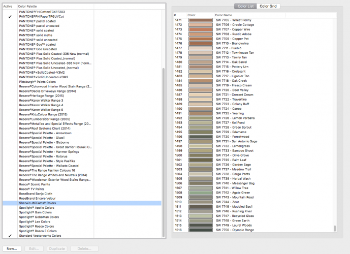
I see the Sherwin Williams color options; however it stops at sw7750. Im looking for SW9093. Can I find the remainder of these colors somewhere? Can they be downloaded?? I will say when it comes to color matching the color picker will work but often gives a color that isnt quite right. Not to mention another layer of complexity is added when you do a final quality render. If anyone knows where I can find these remaining SW colors please share. Thanks!
-
Hmm after a few restarts seems to be working but intermittently. Some times they show up but seems they need a little coaxing?
-
Tried this with 3 different terrain models and none seem to work.
-
Every time I attempt to turn on flow arrows in the site model settings the program freezes? Anyone else experiencing this? Or they simply don't show up.
-
Have you considered making an Auto hybrid symbol?
-
Hmm jumping in here as well as I was recently exploring this feature. Ive found that the objects in design layer needed to be filled by class in order to allow a class viewport override. If they wernt the override would not take place. I have definitely seen it work with a 3d object regarding textures. Not sure about hatching tho. I was under the impression hatching is only viewable in Top plan. Ill try and do some testing.
-
3d point clouds - need to rethink
HEengineering replied to digitalcarbon's topic in General Discussion
Gotcha. Thanks for the pointers! -
3d point clouds - need to rethink
HEengineering replied to digitalcarbon's topic in General Discussion
are you just screen capturing the 2 second images or does your screen recorder offer a frame image output of sorts? Im currently on a mac thats why I ask. I follow the process just looking for the best workflow to get there. -
3d point clouds - need to rethink
HEengineering replied to digitalcarbon's topic in General Discussion
@digitalcarboncan you give us a little more info on just exactly how you got the files from the Google Earth 3d Flyover? How were the files generated? What was the file type and then how were the used? I could see this workflow being helpful for us. -
We are searching for a GIS software that would provide Right of way display and measurement tools. Im not even sure if there is a program out there that offers all the ROW's nationwide or at least state wide? Seems this may be a real challenge to collect all this data, but maybe someone out there has seen something similar to what Im describing? Right now we simply use the county GIS sites, but in a lot of cases its simply lacking the information. Any help or suggestions appreciated! We were hoping for a software package that we could source all our ROW info from rather than jumping to each County GIS site.
-
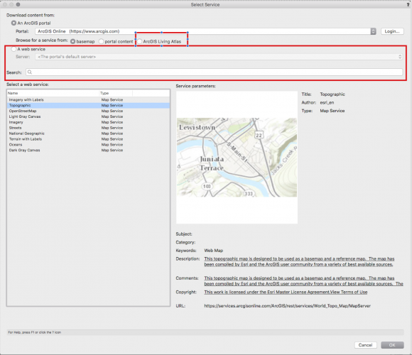
Also another question I have is under the services for the ArcGIS Portal I see the option to add your own web service? Could a person use say a County GIS website and plug that in? Or maybe the easier way to ask this questions is if we have a county GIS site that shows ROW and property lines it would be great to get that integration in? Im fairly new to what ARCGIS living atlas subscriptions offer or like I said maybe we can simply point to a county GIS portal?
-
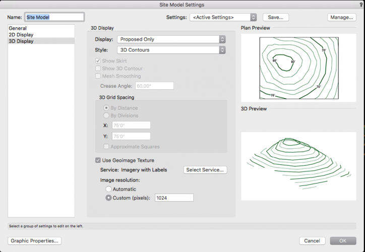
@SMannVW Ok now that video was very helpful. The one part of the workflow that seems to be giving me fits is trying to use an already created terrain model and have that GIS geo image showing over the terrain model. I have checked the box in the site model to do this, but it doesnt always seem to work. Sometimes the terrain model will apply the geo texture other times it doesn't? File attached if you would like to have a look. Document is geo referenced and the design layer is also geo referenced but its very possible Im missing something silly here. Site Model test.vwx
-
A comprehensive video on this subject would be great. I think once people see it in use its so much easier to understand vs trying to interpret the help files.
-
Ive read thru the help and while I can set up a document with the geo-referencing on Im not sure how or what this is actually used for? For example if I set the origin to a specific lat and long I would think that if say a survey file and the points in that file match the points of the georeferenced origin that the point would drop right in the center of the drawing. That doesnt seem to happen. I understand the concept of Geo referencing but the information surrounding how to get it to work for you in VW is sparse at best. Anyone have a good tutorial or can elaborate on their use of this feature? Would love to see how this actually works.
-
We kinda avoided 19 due to some issues with terrain modeling. We use that feature quite often. Right now were running with High Sierra and 17 if you can believe that. We sat out during all the VW19 craziness and 18 didn't really offer anything better than 18. Crazy to think 2 new versions have gone unused for us. We see some things we really like in 2020 tho so that is why I asked. Anyone else that is running 2020 on Mojave please share. Thanks John!
-
How about VW 2020 with Mojave?? Its really hard to know what versions of VW work well with the versions of Mac OSX. We are thinking about making the move to 2020 and updating all Macs to Mojave.
-
2020 Teaser Tuesday - GIS Improvements - Vectorworks 2020
HEengineering replied to JuanP's topic in News You Need
I always wondered how to use this in 2017 but never really tried. Is this something that would allow you to see right of way and property lines as well?


