Samuel Derenboim
-
Posts
472 -
Joined
-
Last visited
Content Type
Profiles
Forums
Events
Articles
Marionette
Store
Everything posted by Samuel Derenboim
-
Quick question, network speed, is it gigabit? or 100mbps? and second - to what degree of a difference would it make loading up the files on both connections? Orso, the command manager looks quite useful. Do you sell your plugins?
-
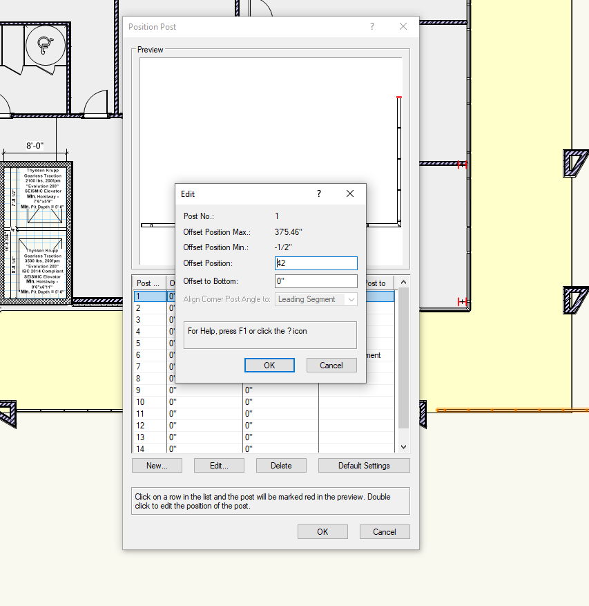
Can someone please confirm - when editing the railing tool - the position feature, when you enter a number into the offset position dialog, it enters the numbers backwards (i.e. when you enter 24, it puts the 4 in front of the 2 making it 42 instead of 24) Also, if you enter the offset position and then modify the length of the railing, it resets the entire tool. Could anyone confirm this please?

-
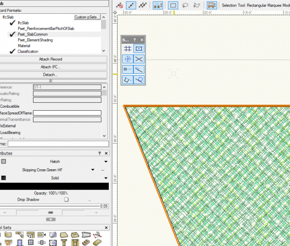
Hi everyone, So I'm creating a new database for our firm, specifically a model database with proprietary and IFC record formats. I'm using a combination of methods in order to import revit, however, so far the operation seems very successful. There are a few snags however, which is why i'm posting on here. With different manufacturers, the record formats are also proprietary, and are often different formats. merging them into one can be a hassle. I know that there is a merge record function. However, it is on a one by one basis, which makes it a bit difficult. The problem is this, when i import revit, it makes duplicate record formats for every model that I import into a file. So let's say for the sake of arguement, I import 15-20 GE light fixtures. Out of those light fixtures I will probably get 8-12 separate record formats that are duplicates for every model. Is there a way to mass merge record formats? The reason being - if i delete them, it will ask me to either replace them or delete them outright. Some fields in some fixtures are added, and can be slightly different from record to record - so my question is - Is there a function to mass merge record formats? rather than mass delete? Thank you in advance everyone!
-
the annotation tool can't pull out custom record information as far as i'm aware of. The idea is to infuse record information into a symbol libary, and pull out the information at will when constructing new details, or perhaps calling out component names in detail cross sections. There is a function I believe that can take notes out from a central database, but that's not the same thing unfortunately. one is centrally located in a database, thats not exactly associated with a symbol, and the other is simply a symbol having record information. But I think youll understand my meaning. adding this function to the annotation tool would be great, the only problem is that you can mass appropriate it to all the symbols like you can with the tag tool. When i discovered that feature, i was like....😍 Also, regarding tag tool parameters : 1. is there a way to call out wall length? Only wall thickness and wall height can be called out, but not length. I was preparing on using the two parameters so that i can run a script to compute the surface area (wall length x wall height) into a separate record - perhaps that can be called out by the tag tool. 2. The second, not as straight forward idea is that you can have conditional statements in a tag. Lets say you need the area of a window, door, window wall or wall in one tag. Normally under these circumstances you can't pull the information out in one tag, but rather three separate tags, which would kinda make it a little less convenient in using it under varied circumstances. What if in one tag you can specifically call out areas in all three, having different parameters. i.e. if object is wall -> use #Wall outer surface area# (if it exists) or custom record that calculates wall length x wall height if object is a window -> use #Window#.#OverallArea# if object is a door -> use #Door#.#ClearArea# you wouldn't believe how conditional statements have saved my life on severe deadlines regarding energy calculations needed for the department of buildings, or tabulations for zoning, building area, gross area, etc... I can send you some samples on how i used conditional statements in worksheets that ultimately saves me a week of work in a matter of minutes. Again, the second one isn't as important as the first. some basic functions are needed to at least tabulate dimensions, areas, etc... of walls, windows, doors, geometry etc... So far, I've been using the annotation layer in viewports to draw out 2 dimensional geometry specifically for that purpose. For rectangles or polylines, its much easier to pull out length, width, area and height parameters. The only problem is that it defeats the purposes of building information modeling, or at least adds another layer to get the information i need not readily available. i actually want to use the new data visualization manager this way, the lack of some of these functions are making it a little difficult. This would be a game changer for take-offs too. Again, thank you for considering these things in your next iterations. I would never expect something like this from Autodesk. This is one of the main reasons why I remain, and will remain with Vectorworks. Thank you very much for your help in the matter!
-
Thank you for responding TDimov. That's right. It would work like an annotation tool, but with record information. This would be very useful in details, and specification consolidation when coordinating with clients, contractors, reps, and shop drawing techs.
-
Guys, you hit it out of the park 🙂 Just a few questions : 1. Will we see any way tags can call out levels (not just stories)? 2. Is there any way to call out the surface area of a wall without calculating all 4 sides? (the longest surface side only is what interests me the most), or surfaces based on the component? For me, I would use this for the purposes of calculating fenestration vs. solid walls for energy code requirements in NYC, and calculating wall area take-offs / costs. 3. Will we be able to modify text positioning in a tag without editing it - in terms of text. Let's say you need to resize the text field in just one tag, rather than resizing all tags, would we be able to look forward to something like this in the future? or is this something the asymmetric scaling can take care of? Combining data looks very promising! Finally i can combine custom records with VW records and IFC based records without having to modify each one! Still playing around. Thank you for your hard work!
-
Ah, alas, can't have everything. Im trying to create a consolidated library of information, i do have alot of 3ds and obj files to import. Hoping i would be able to conserve time by mass importing 3ds, but seems i might have to convert to obj or skp before i can do that. Keep you updated 😉 Thank you Marissa!
-
hi everyone, Trying to figure out procedure callout in python for 3ds import. For OBJ for example it is : vs.importOBJ(filename, True) for sketchup vs.Importsketchup(filename, True) i have tried vs.import3ds(filename, True) and vs.import3d(filename, True) I'm trying to create another import node for 3ds import based on DOMC's import sketchup script. So far it worked for OBJ, but can't seem to be able to get 3ds to work. Maybe someone can help me please? :)
-
Trying to convert RTE revit library files
Samuel Derenboim replied to Samuel Derenboim's topic in Architecture
Any suggestions on mass importing sketchup files? while we're on the topic? 😀 -
Trying to convert RTE revit library files
Samuel Derenboim replied to Samuel Derenboim's topic in Architecture
OK. Mind.Blown.com! Thank you Vasil! -
I don't know if the team is aware of this issue yet, but.... If tags are used in worksheets and the id or a record is modified inside the worksheet, the tags (that display the custom id or record) don't auto update the custom ID in the viewport unless they are moved or edited directly. In other words, it appears that the tags 'know' they are updated, they just don't update their appearance until they are moved. This is specific to custom records only i believe. Could anyone try something similar to see if I'm not unique in this department?
-
Custom ID tags for windows and doors
Samuel Derenboim replied to Christiaan's question in Wishlist - Feature and Content Requests
we need to be able to scale the data tag tool, and / or provide text styles to them (text styles can be different sizes depending on how they are used as well). I'm trying to integrate them everywhere for annotation. Other than that, I have no issues with the data tag tool, it fixes so many issues! speaking of which, i think i just found a bug ) Ill post it on another post, but if tags are used in worksheets and the id or a record is modified in the worksheet, the tags (that display the custom id or record) don't auto update the custom ID in the viewport unless they are moved or edited directly. In otherwords, the tags know they are updated, they just don't update their appearance. This is specific to custom records only i believe. -
Hi everyone, I've been trying to create a standard catalog of wall types with UL, R and STC values in VW. In light of saving time, i was wondering if it was possible to import standard library types that are provided by manufacturers like USG or similar? They only provide RTE file types for some reason, and i cannot get them to be imported into VW. Any ideas ? (Other than getting a trial of Revit, importing the wall types into there and then saving it as an RVT file...lol) Thanks!
-
Worksheet Improvements
Samuel Derenboim replied to A.D.K.'s question in Wishlist - Feature and Content Requests
Also, is it possible to make hidden columns? (For calculation purposes, or referencing information that shouldn't appear in the worksheet for modification purposes) -
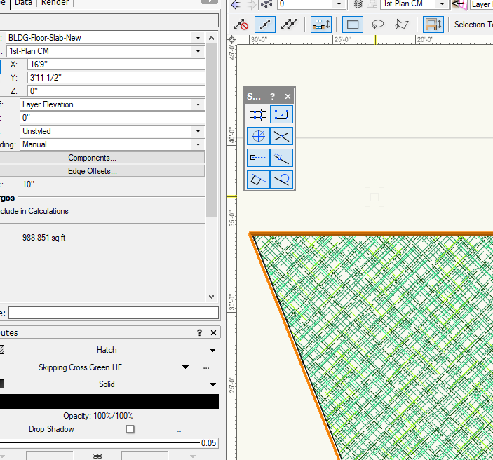
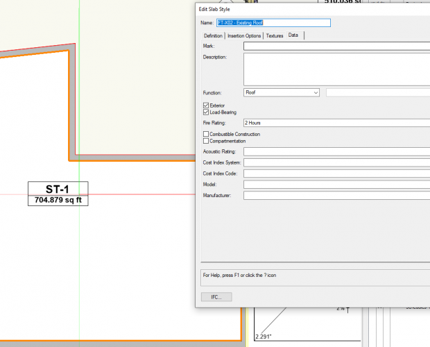
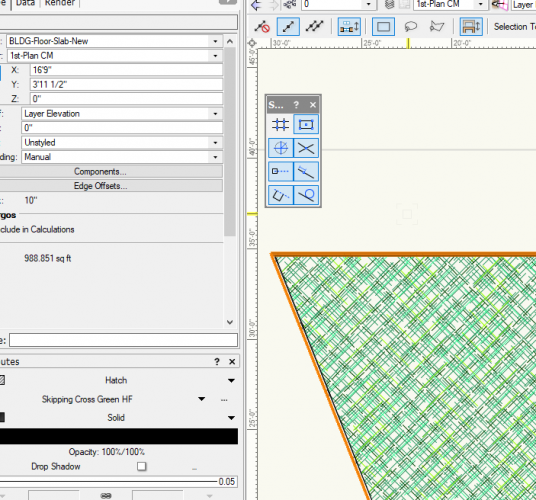
Hi Everyone, Just might have found a new bug. Floor slab retains old style ID when imported from another file, even after deleting the ID entity from the floor slab itself later on. To make things worse, after I have created a separate floor style (I didn't want it to be included in the schedule), i though it would disappear completely, and turns out it doesn't. Took me a bit of tinkering to figure out this bug because i was trying to create a schedule of existing and new floor types. *Update When renaming and resaving the ID field, it changes the ID in the schedule. However, when reverting back to a blank in the ID Field, it reverts to the old imported ID. Image below shows that the slab is 'unstyled' However, if you go to the IFC_SlabCommon record field, the imported ID is grayed out UPDATE 2: For some reason when creating a new slab, the ID defaults to ST-01.
-
Anyone who knows how to host a mysql server - OrangeHRM is great. I'm hosting it on windows for now with XAMP server. Linux is by far more secure however. It's opensource, so the hardest part is learning to how php / mysql server on localhost or local server and managing ports / domains with a LAMP box. If web is necessary, using dynamic dns along with pfsense or kemp loadmaster for reverse proxy. Make sure to use SSL for security (i.e. www.sslforfree.com or letsencrypt) The only thing you might need to pay for is a domain, but there are plenty that are also free - like DDNS or something similar. Google offers ddns services, so as long as you have a ddns client on the server that connects to google domains, you would be good to go. FYI a domain through google is about 15 dollars a year, so it's relatively cheap. Everything in here thus far is opensource, and is free to use so long as you know how to implement it. FYI, learning curve can be steep.
-
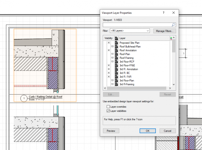
Can't grey out layers in detail viewports
Samuel Derenboim replied to Samuel Derenboim's question in Troubleshooting
Thank you Adam! -
Hi Everyone, Don't know if everyone has this, but detail section viewports, can the layers be greyed out? For me that seems to be an issue as - if i enable the greyed out layers or the full view layers, they all appear the same. Note i have the latest version (2019) and service pack 4. Thanks for your help!
-
Worksheet Summary Problem w/ Tags and Geometry Ref
Samuel Derenboim replied to Samuel Derenboim's topic in Architecture
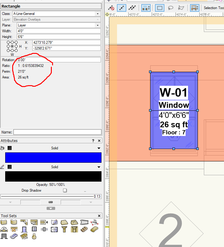
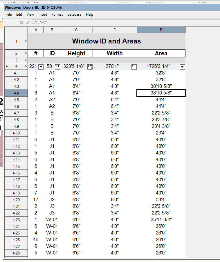
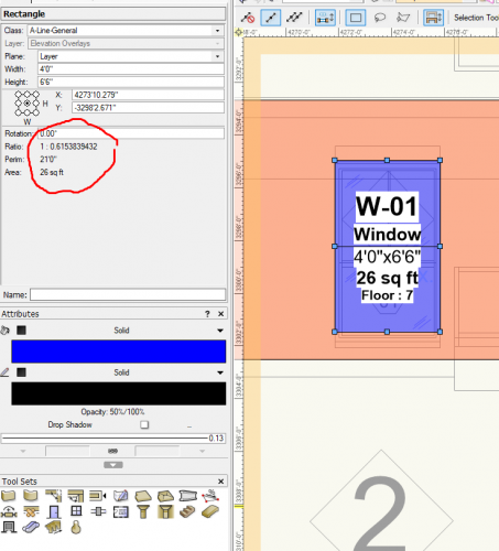
Update - Noticed that despite having the same dimensions, the ratio of the objects are different. Is there a way to globally update all objects ratio without having to re-enter the dimensions of every single object? The moment I update the dimensions, or retype the dimension, it updates the ratio. This also helps with the summary - it starts to summarize the contents of the the file better. Is there a way to auto update the ratios of all of the geometry that have the same dimensions dynamically? or is there a way to re enter the =height and =width columns (they remain grey). It might help with the ratio problem.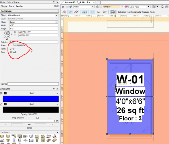
-
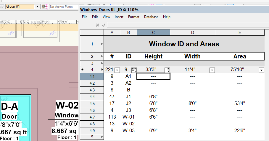
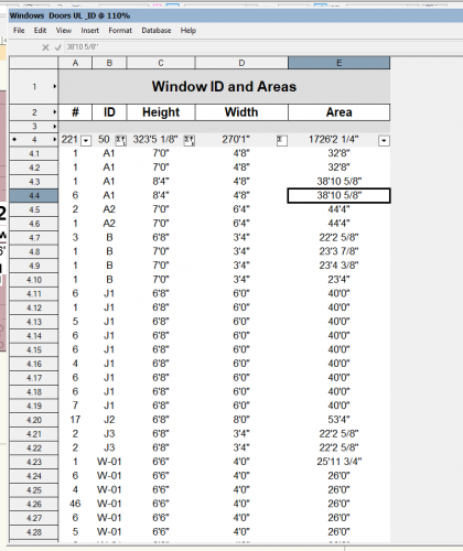
Hi everyone, Maybe someone by chance ran into a similar problem? I have a series of elevations where i used geometry and tags to summarize window heights and window widths (among various other elements) in a worksheet. Normally, when i do window schedules, or door schedules in a bim model, the information doesn't repeat when i enable 'summarize items'. Here, for the life of me, i can't figure out why when i summarize by its id (custom record), by the geometry height =height, and by geometry width =width i get repeated elements that wont summarize, even if they display the same information. but when i just summarize by ID i get this Perhaps someone can help me out? Thanks in advance!

-
WISH- A "stories wizard" menu would be wonderful!
Samuel Derenboim replied to J.Samuel's question in Wishlist - Feature and Content Requests
or rather to freely modify the elevations and stories similar to the way revit does it. I would think that's simple enough? -
dwg export - color/line weight by class
Samuel Derenboim replied to Samuel Derenboim's question in Wishlist - Feature and Content Requests
You can't if you export a master design layer with plans shown as design layer viewports. You have to either explode them, or export sheetlayer viewports separately. The consultants I work with scream bloody murder when you make them put together all plans and elevations into a master file. Exploding the viewports would take forever in a large BIM file in order to convert all referenced design layer viewports into linework / polygons. It is also impossible to set viewports overrides to show line color by class, unless maybe iI'm missing something? There is also the problem of exporting to separate dwg files, different symbols might have the same name in different exported dwg's. So when you copy an object like a door in one dwg exported from VW, for some reason, it pastes a window in another dwg exported from VW simply because the symbol was named the same upon export, or perhaps the same symbol with a different insertion point. So I figure it's simply better to have one master layer file. -
Data Tag scaling
Samuel Derenboim replied to Samuel Derenboim's question in Wishlist - Feature and Content Requests
Sure, I can give several. 1st file - Annotations for details. Description - record format would be assigned to different components to annotate a detail. The size in a data tag is constant - and cannot be changed. Therefore, in order to accommodate different scale types for detailed drawings - scaled data tags would be appropriate to retain the text size in sheet layers. It would also help if the data tag had scale handles for text. Note how viewport outline is the same symbol only scaled proportionately to the viewport sheetlayer scale in order to fit into the same grid box in the sheetlayer grid Text Size Appears the Same in Sheet layer viewports because differently scaled text appears proportionately to the sheetlayer viewport scale. In this particular case sheetlayer viewports are: 1. 8"=1'-0" (1.5:12 ) inside 3"=1'-0" Design layer - 10pt text at 1:1 = 3.8 pt. - Datatag Scale designed in 1:1 would be scaled 1.5x 2. 2"=1'-0" (6:12) inside 3"=1'-0" Design layer - 10 pt txt at 1:1 @ 2" = 1'-0" = 15 pt - Datatag Scale in 1:1 would be scaled 6x 3. 1"=1'-0" (12:12) inside 3"=1'-0" Design layer - 10 pt txt at 1:1 @ 1"=1'-0" = 30 pt - Datatag Scale in 1:1 would be scaled 12x CONCEPT : Data tag used as annotation for detail callouts. In order for it to be used - the data tag callouts must be able to scale the same way as Symbols can 2nd File - Area Summations (Floor area, zoning, building code, etc...) Description - Area takeoffs in this file are used for zoning take-offs, and are to be displayed dynamically on the polygon / rectangle with the appropriate record format. However, when you have a 1:1 sized data tag - in the design layer viewport - it is disproportionate to the rest of the drawing - depending on the design layer scale. In this example - I've shown the different sheet layer viewports at different scales demonstrating difference between the same callouts in the annotation portion of a view port and the design layer viewport itself. Concept : Generally it is preferable to control the tag in the design layer viewport - because of any underlays that might be shown in different drawings - if they are needed. It is easier to move them out of the way in the design layer viewport than in the sheetlayer annotation viewport. Additionally - Consultants will not see these tags in the design layer viewport if a master design layer is only exported. Hope this helps! Sample 1 - Data tag scale.vwx Sample 2 - Floor area take-offs.vwx -
One annoyance that engineering consultants using cad have complained about is that when we export files, they end up being a single color (if we work in a black and white line format). Noticed that color by lineweight can be exported, however, color by class and line weight by class isn't an option. I believe that is one of the most important, if we set up the class settings in our work flow, all we have to do is export it that way. That can be done in cad, however, the command - set to layer - is only in autocad. If consultants work in anything other than autocad, they cannot convert to color to class (or layer in this case) in blocks or groups. Hope this can be added in the future.
-
I love the feature where symbols can be scaled proportionally to itself in order to provide the correct size of lettering for paper scale. One of the things that I do on my drawings is create a 1:1 scaled symbol, and then scale them proportionally to the drawing size. That means, if it is a 1/4"=1'-0" drawing - i scale that symbol 48 times - to get the same appearance as i would at paper scale. One of the many benefits of this feature is that I can share this with engineers or other architects that use Autocad. Unfortunately, when symbols are inserted in annotation, the drawing itself has to be exploded and scaled back again in model space. This is why the scale feature id design space is so useful. Here is the question - I want to do the same with a data tag tool - precisely for the same reasons. Currently, I've desiged a 1:1 tag and use it in annotation space. If I were to use it in Design layer space - i would have to again - scale appropriately - after I have inserted them. Is it possible to have an option to create the tags at a certain scaled size - IE 10x, or 12x etc...? Wonder how others do this. I know this is a new feature, but it has certainly opened a totally new world for us in terms of parametrics, so way to go VW, couldn't love this data tag tool more!