


Kevin C
-
Posts
158 -
Joined
-
Last visited
Content Type
Profiles
Forums
Events
Articles
Marionette
Store
Posts posted by Kevin C
-
-
- Popular Post
I think it's a real shame that we as users continually feel that we are 'fighting against the machine' so to speak. As a small practice (me + 3 in the drawing office - although they are all wfh just now), the issues surrounding office standards and practices are more acute now than ever more.
@_c_ Could not be more to the point. Any practice should want to have systems in place, where one staff member can jump into another's project with little or no 'orientation' for whatever reason: holidays / leaving / off-sick / paternity / maternity - The reasons for this are endless and VW just doesn't help.
On 12/4/2020 at 5:35 AM, _c_ said:- Project Sharing
- Stories
- Drawing sync items (grids, labels, etc)
- Data Tags
- Resource sync
- real workgroup management (spilt damned preferences from libraries)
- etc...
We as a practice have given up on project sharing as it just doesn't suit - too many 'management' protocols and procedures that can and have gone wrong every time we tried it. The rest of the list is a major concern that just doesn't seem to be getting addressed.
So what do practices do? - We just carry on doing our own thing as we have all pretty well resigned to the fact that there is in actual fact very little 'productive' support for the architectural field. I keep hoping that the wishlists that have been going on for years - doors / windows / stairs / walls / roofs etc. will actually be answered and that the tools will 'Work as Required', not just 'Work as Designed', so we don't have to continually have to do 'workarounds' to basically do our jobs.
If I were to go off-piste and mention a tool that VW seems to have devoted a lot of time to, but with totally unusable output in real world situations, is the Title Block Manager and the facility to generate drawing registers, issue sheets etc. I do not know a single business anywhere that does not have even the most simple word processing and spreadsheet software and the larger the practice, the more likely there will be a formal drawing management system in place. The unfortunate reality is (and I'm including those practices who I speak to who use REVIT and AutoCAD ), no-one uses the 'in-built' drawing management systems. Wouldn't it be really nice if when drawings are changed and issued, that vectorworks could 'talk' to a spreadsheet (let us worry about how it looks and is formatted) - just give us the codes and datasets to do it (we can all create macros, its not difficult - Microsoft even shows you how to do it on their help screens).
Also, please get rid of the Notes Manager - It needs to be re-written from first principles allowing users to import their own documents and notes
Moving on from that can you please, please look again at how Vectorworks is installed in computers:
points of concern (really disgust):
- Move forward with the times - There are now multiple ways in which businesses manage and access files. NAS storage and cloud storage are now mature and probably the norm in todays IT world. Not everyone wants to work either of their local computer only or off a fully fledged server.
- Only core project files should be stored in the local computer folders
- When installing Vectorworks, we should be able to where to store libraries where we want to: Why would you want to store libraries locally when your projects are all being stored on a server, NAS or in the cloud? Everyone in a practice should be accessing and using the same components documents libraries etc. having multiple local copies of libraries is just asking for trouble (and a waste of space).
- Allow user profiles to be 'portable'
-
 5
5
-
Is there any reason why Vectorworks Cloud Services only allows integration with Google Drive and Dropbox? More and more users are utilising many other online sharing platforms (specifically in the current working from home situation) such as Microsoft OneDrive and Box as well as a myriad of others.
Does VW have an arrangement with Google and Dropbox, or is it just another one of those things that no-one has thought might be useful to the users?
-
4
-
-
I have been trying to create a model using cloud services so that my client can see proposals for a site. I have stripped back the vwx file as much as I can and when I upload the file to cloud services to create a vgx file, it just gives a blank screen (54.3 MB of blank screen).
Can anyone help - Vectorworks UK support is closed for the holidays and I need to get this sorted by the time my client comes back from the Christmas break.
I've attached the file and a link to the vgx file (cannot upload in here)
https://cloud.vectorworks.net/links/11eb490c469a136a8fce0e8109945acd/
-
Luis,
I was asking if you could create a working package right now. Ie you will be creating the renders once all the internals are in place - walls / floors / doors / furniture / specifications etc. If I have an empty model (nothing on the in side) - yes, I can create these effects, but not once the model is a working model - it gets too bloated.
-
Luis.
These are presentation files (very nice I might add), but I am looking to generate working files. This is one of the biggest issues I have with VW - We are not there to create 'beautiful and pretty and awe-inspiring' images 24/7, yes sometimes - but very rarely. I need to produce working elevations from a working model that is being worked on and people will be building from.
Can I ask a question re the picture you posted. Can you create a set of working, fully dimensioned and specified plans, sections and elevations from the same model?
-
I am using the most basic Open GL.
The 'textures' are solid colour clocks with no 'special effects' and the coursing being carried out by a simple brick hatch. It needs to be this way as renderworks textures have now proven to be far too overly complicated. The other real problem is that to create a viewport that can be printed, the resolution has to be at a level where there is no pixelating of the image - i regularly have to go up to 305 dpi to get over the problem (which again just adds time), but in this case I was rendering at 72 dpi.
The real issue is insisting that the drawing needs to be rasterised. Why??
-
On this thread - I wonder how much of an increase VW will be imposing this year? All the meaningful improvements last year were not in the building sector - same again for this year (please note I said meaningful - which I mean fixing the long standing problems which VW has).
Spreading the costs doesn't really help anyone in the long term - the bills still have to be paid, and if client's aren't paying bills: where does the money come from?? Things like wages and rent come first.
Every September (for the last 3 years at least) I wait with bated breath to see if the broken parts of the software have been fixed and this year unfortunately there is no change. The VSS subscription cost is extremely high (I have 4 licences for my practice) - I understand that you need product development to improve and bring new features but please please fix what's broken and then we won't begrudge every renewal (not loudly anyway).
I am actually of the mind that many people are maintaining their subscription in the hope that they will get a piece of design software that does what is says on the tin. There are other very competitive alternatives out there and there will come a time when we will have just had enough and go elsewhere.
-
2
-
 1
1
-
-
This is probably a question that has been asked many times before, but I have difficulty in accessing it, so here goes.
The vast majority of our day to day work is to produce plans, sections and elevations to a standard that can easily be understood by clients, statutory authorities, contractors etc. I am not trying to produce photorealistic or 'high resolution' renderings on a daily basis - I actually don't want to produce a render, I would very much like Vectorworks to draw a set of lines that are representative of an elevation or a section and the ability to add some colour or detail without having to create an 'image' and worry about the resolution, the giveaway is in the name - Vectorworks - means lines, the name of the software should really be changing to Rasterworks as it is nearly impossible to produce vector drawings. The problem is that we need sometimes just to see what something is going to look like quickly and to produce an elevation or section from a model that shows just a modicum of colour or detail, is now so complicated that we as an office have all but given up trying to do it - doesn't look good when trying to run a business.
How come that to generate the model in Open GL in the design layer, spin it around to my hearts content, zoom in and out, switch classes on and off, take screenshots etc. only takes seconds, but to generate the same level of detail in a sheet layer can take hours??
The real reason for this post however is because I am sitting at my desk trying to generate a set of simple elevations - taking 20 minutes each time because if just one thing is changed in the entire drawing, everything has to be generated from scratch again.
And we wonder why other designers are continually mocking Vectorworks - ability to create instant and live elevations / sections. Live updates etc. Come on guys - what's the problem????
-
1
-
-
Thanks Rick.
-
1
-
-
That's either a bug or a screwup in my view.
-
Did so this afternoon (after first post).
-
No.
My practice has been using VW since 2009 - I know what a bug is.
Procedure:
Start VW2021
New drawing (Architect Metric template)
Draw something (I drew a wall)
Draw a dimension - it may work
Go to document settings/units and change the dimension tolerances (I picked 3 decimal places)
Create a dimension - there's no dimension text.
To fix, you need to go to Text/size and select a text size - it seems that the text size is not selected (I picked 12 points). That seems to permanently fix the problem.
-
No this is VW2021.
It seems that it might be a Mac issue. I have managed to sort it by pure chance.
It seems that the text size needs to be selected and then the dimensions appear. But unless this simple step is taken, the dimensions do not appear.
-
Please help.
The dimension text disappears if the decimal precision's changed in the 'Document settings / Units / Dimensions' dialogue box. It doesn't just disappear, VW can no longer dimension - even if it is changed back. Can this be looked at as a priority.
-
- Popular Post
- Popular Post
I was hoping (almost praying) that the people in Vectorworks had listened to our pleas for a design tool this is as good as others in the marketplace, but to no avail as they know that we are all tied in to them and to change design software would quite simply put most of us out of business.
It is really saddening that we are still having to voice our complaints of basic errors in the software and no-one is listening - or caring by the silence. have the programmers even looked at this issue? My own view is that they have and realised that their coding (or whatever) needs to be ripped up and started again and we (as building designers) are not high enough up the food chain to warrant it being reviewed.
I think that we need to start the 2022 wishlist now, but with a few mandatory exclusions to allow resources to be spent where they are needed.
- No changes to the UI - It's not perfect, but it works well (and has done for quite some time) and doesn't need to change every year
- No improvements to concept modelling or any of the 'early design stage interfaces' - It's not perfect, but again they work
- No changes to the fancy coding algorithms for design (like marionette) - how many of your user base actually use this??
I could go on, as I realise that you have to innovate to improve, but this should never be at the expense of your existing users.
Wishlist (not numbered as all are priority):
-
Door / Window tools - I could write a couple of thousand words on what is broken (and it has all been said before), but I will summarise below:
- Being able to choose the anchor location of a door or window (not the centre of the window) such as the inside or outside of outer leaf of the external wall component in addition to the centre of the wall
- A simple check box to wrap the internal component(s) (if one exists) round the internal reveal up to the door / window frame. This could easily be identified by setting the component(s) function in the wall style to 'Internal Finish' and those components could be wrapped. E.g. plasterboard or plasterboard and service void etc.
- Allow us to anchor our own 3D components to windows and doors - cills (internal and external) / lintels (internal and external) / thresholds etc. as VW just cannot seem to get it right after many years of just not being able (or bothering) to fix it.
- Being able to add roof windows and dormers to window schedules - treat the roof like a wall.
- Roof Tool - Just rip up and start again (Not the freeform modelling which I don't think that very many people use, but the whole roof tool - it is just basically crap and not fit for purpose, as said before - treat it like a wall)
- Stairs - Multi level stairs required. Not to all buildings are 2 storey (I think you know that though)
- Get the new features working properly before release - Thinking about the new join railing / fence feature. Really needed fix (not improvement), spend a good 2 hours yesterday evening - couldn't get it to work
- Walls - Ability to change components in a wall elevation. Easy solution would be to allow us to simply cut out part of the external leaf (in 2D and 3D) and replace it with our preferred material - a single component wall for example - we could then quantify it!!
- Review of the curtain wall - allow us to edit components and move things like mullions and transoms using the move object command within the 'edit curtain wall' and not having to drag components
Notice a common theme - These are the tools which we all require to use on a near daily basis, they need to work properly and without having to use 'workarounds' or annotation overrides' just so that we can produce a competent set of drawings.
I put it out there - If we have to end up exploding and breaking up our model to edit it, then draw over the model in annotations to get an output drawing that can be presented to a contractor to build it for example - What's the point in drawing in 3D in the first place??
-
7
-
Unfortunately, it's not locked or anything fancy. It's just been created using a raster pdf maker - I.e. it creates an image only and not the vectors required to convert to lines. I wouldn't think it has been done deliberately, just the way the originating firm has done it.
-
Very simple solution, but only works if the pdf has been created using vectors and not by rastering.
- Import the pdf into a new blank drawing - choose design layer and scale to suit yourself
- Scale the pdf to the size you need it to be
- Ungroup it (cmd + U)
- Click away from it (to deselect it)
- Delete the 'bitmap' image - This should be on top
- You should be left with what looks like a filled rectangle with nothing in it
- Select all objects (there may be a number of groups and sub-groups - don't worry about it) and change the fill in the attributes palette to 'None'. It would also be good practice to change all lines to solid black with a thickness (I usually go for 0.18mm or 0.25mm)
- Ungroup everything (as many times as it takes)
- Delete the junk you don't want
Line drawing created.
As a side note - any solid fill will import and convert as a bunch of unfilled polygons, and you may get RSI from methodically going round the drawing and clicking to delete.
-
Tasmin,
There is a basic misconception in that we should be working in anything other than real world coordinates.
Project coordination is critical to the exchange, in VW to confuse matters, there is a drawing origin as well as an internal origin. I have watched your webinar a number of times and it assumes that we all work of local grids and that we can decide where the origin is placed and in the 'rare' occasion when you need real world coordinates you have to ensure that the drawing is set up correctly. - WHY!!!! The UK templates already have the OS coordinate system input, so why does it not work.
Too give you an understanding of how my projects are set up (site layouts etc.) - not individual designs
- Start with a blank metric template
- Import the OS Map (geo-referenced) - using the settings below
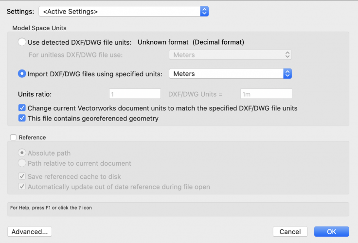
This warning comes up. However, I know that the OS map will have a distant origin (I.e. - 0,0,0 could be hundreds or thousands of miles away - but that is correct), because if it didn't, I wouldn't be able to generate coordinates or share with outside parties.

- Do a quick check 'Geo-image' overlay to make sure that the site is correctly located according to VW (It always is doing it this way)
- Set the user origin to match the GeoRefencing coordinate system (If I don't do this, I cannot export a coordinated drawing)
- Import the topographical survey (if the above has been done, they will all overlay each other). Neither myself or my clients will not commission surveys that are on a local grid.
- Start drawing the site layout
This works fine until I want to bring in a model (usually by referencing). The building model is always created on a local grid (centre of drawing on 0,0,0 etc.), but when brought into a real world scenario, it just fails.
It is so easy to make a simple change that knocks the whole system out.
1 hour ago, Tamsin Slatter said:Once the agreed project coordination point is set in the user coordinate system and positioned over the internal origin, real world coordinates will be preserved
I'm afraid to say - this statement is incorrect. VW does not do this. If you look back in the tickets I currently have an outstanding ticket on this matter (from April I believe) with this exact same problem.
-
1
-
Unfortunately, I think that its your fault (same as its my fault when I try to do something), call me daft, but whenever I create a drawing, I would like VW do do what I ask, and every time I get told the that it doesn't render properly is because "I haven't set up the drawing origins properly???"
Please remember:
- We always deliberately setup drawings hundreds or thousands of miles or kilometres away from the origin - don't we ???
- We have no intention of ever interacting with other consultants or god forbid having someone set out a building or site from our drawings ??
- We don't want to be able to use geo-referencing or import a geo-image and have it land correctly onto our site??
- We don't want to be able to import or export with the knowledge that it is correct ??
- We don't really ever want to create a simple thing like a rendered elevation??
Come on VW, being serious for a minute. This is a problem with the basic programming. If it is so important for the the program to be at the drawing origin / internal origin etc. etc. to be able to create a basic render - do something that makes the drawing origin / internal original go to the centre of the drawing, but don't play with the coordinate system - that is what we use to set thing out.
When I download an OS Map from Promap (in the UK), the coordinate system is already setup so that when I drop in a topographical survey, it should align perfectly, and guess what - it does. You have to remember that we also export files for others to site use and the universal format is dwg - not VW. Also when building new properties (in the UK), there is a thing called DPA (Deed Plan Approval) - this is an electronic title that the keeper directly imports and generates the title plan from and guess what, it has to be generated in a dwg format and it also has to be coordinated to the OS grid (the same one that was used form downloading the original OS Map from). If a user based coordinate system is present on the drawing, guess what - it doesn't work.
VW can you please stop berating us for just wanting the program to work and listen to the constant repeating statement - there is a problem.
My suggestion (very basic as it is).
- Assume that everyone will be designing a structure that has a real world location - and that it will not be centred on 0,0,0 - it will positioned to match the real world coordinates for whatever country they are in and allow the program too change its internal origin to suit, but without changing any coordinates that we as users would use.
- If someone wants to use a shifted UCS - let them do it, but please do not assume that it is the norm
-
2
-
1 hour ago, yasin2ray said:
the north arrow does not always have to be facing up. It is acceptable to rotate the drawing in construction drawings - as long as the north arrow is pointing in the direction of north for the drawing presented, of course.
This is the whole crux of the problem. Yes, the best practice is that the drawing (especially when it is a site drawing) should be orientated North, with the arrow. The problem is that the North point is Vectorworks doesn't point North when the drawing is facing North - it is off and you cannot change it.
There is a bug. My thinking is that some bright spark has decided that we should be orientating to 'True North' or 'Magnetic North' where in fact we orientate to 'Grid North' - something that every country has their own grid north for and it will vary slightly depending which country you live in, but North in drawings is relative to a defined set of coordinates and it always has been.
-
1
-
-
There is a very easy way of bringing a pdf in - just drag and drop it into a new design layer.
If the lines in the pdf are selectable, you may also have another wee gem in your arsenal. This will either work or will not - no half measures.
If you ungroup the pdf, it should split into two objects, a bitmap image and a 'group'. Delete the bitmap and select the group and make the attributes as having no fill and a solid line. Ungroup the group as often as you need, but each time make sure that you make all the attributes to the objects have no-fill. You should now have a full line drawing which you can scale etc.
PS make sure you save your work often as VW still has a tendency if you try and do an 'undo' during this process and you're not careful.
-
1
-
-
here was I, scouring about the forum to see if I could find a solution to a roof problem I am having (yet again) and came across my nemesis from a VW employee
8 hours ago, jblock said:I have seen something like this before with extraneous geometry that is located very far from the rest of the drawing or the internal origin
Guys (and I mean VW), if there are so many of us users constantly having problems with 'internal origins' and the way files are displaying, does that not give you a very strong hint that it is not us that has the problem, but you insisting on having such a stupid origin system. Remember that when we create projects and use REAL WORLD COORDINATES, we cannot draw at 0,0. The VW internal origin should simply be positioned at the most central part of the drawing and have no relation to the coordinate system being used and should be a simple single click that does not change any of the displayed or user coordinates. We should also be able to change the internal original without affecting the drawing.
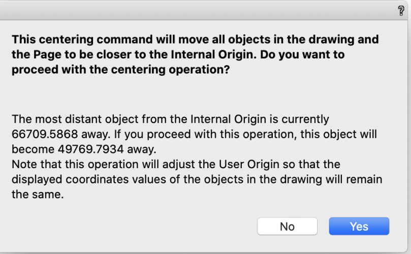
Attached is the dialogue box which appears when asking VW to central the drawing on the internal original. I'm going to tell you a secret - Here in the UK, not everyone livers in Greenwich, why the hell would I want to centre my drawing on the Greenwich Observatory? As I can assure you that VW does in deed change the coordinates when I accept this dialogue.
I currently have an outstanding ticket with VW UK (it's about a month now), where I spent over 1.5 hours on an shared screen with VSS Support, who at the end had to admit, VW shouldn't be doing what it was doing - Ie. unable to render unless ALL the coordinates were changed to match the internal origin (I.e. lose all my geo-referenced data) and agreed to submit to VW. Still haven't heard back.
My unfortunate view is that the techs have been decided that for nearly every real world problem, the program is WAD - sorry guys, simply not true.
-
2
-
 1
1
-
-
Out of Date - VW2020 SP 3.1 on OS 10.15.5
-
Anyone noticed the Autosave in VW switching off by itself. VW has just crashed again (second time today), but this time I have just lost 5 hours of work. I know the autosave was on this morning as there are autosaves from this morning's work, but nothing for the last 5 HOURS. Does VW have a hidden keystroke that switchers Autosave off - If there is it should be deleted.
I am getting so sick and tired of the instability of Vectorworks and the constant crashing of the software. You know you have the users tied down so much that we cannot afford to move elsewhere. Businesses across the world just now are struggling for basic survival.
-
1
-


Cloud Services and OneDrive Integration
in Wishlist - Feature and Content Requests
Posted
I think what has happened during the pandemic is that businesses (mine anyway) have started to look realistically at multiple backup and redundancy solutions. The simple fact of a computer breaking down and being able to re-configure remotely or dealing with a server / internet disconnect is getting more and more complicated and unfortunately happening more often.
A great number of businesses are using Microsoft exchange and Office 365 for their email and 'Teams' communication and it's just that you get a very competent online storage and file sharing facility as part of the basic package.
My practice operates 100% Mac and we use OneDrive - seamlessly, It was just a thought.