Jump to content

Temperature Chart 3.0.0

   (1 review)

1 Screenshot

About This File

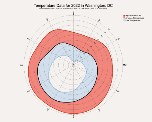
This is a Marionette Object that downloads weather data from the internet based on the address/location you enter into the OIP. The data this graphic shows is the max, average, and min temperatures per month at a specific location. You must have a valid internet connection to use this MO.


What's New in Version 3.0.0   See changelog

Released

No changelog available for this version.

  • Like 4

User Feedback

Recommended Comments

  • Vectorworks, Inc Employee

This should work anywhere in the world. To look up a location outside the US, you can write "[City], [Country]" or even a more specific address in the Location field in the OIP. What that field does is it takes a location and converts it to latitude and longitude. It then searches the Iowa State University's database of weather stations (https://mesonet.agron.iastate.edu/request/download.phtml?network=AWOS) and downloads data from the three closest stations to that latitude and longitude. You can change the number of weather stations that it queries if you want. The most accurate data is usually found at airport weather stations, so if you want to type in the location of the nearest airport, change the Num of Stns to 1 and you will get only that weather data.

  • Like 2
Link to comment

Join the conversation

You can post now and register later. If you have an account, sign in now to post with your account.
Note: Your post will require moderator approval before it will be visible.

Guest
Add a comment...

×   Pasted as rich text.   Restore formatting

  Only 75 emoji are allowed.

×   Your link has been automatically embedded.   Display as a link instead

×   Your previous content has been restored.   Clear editor

×   You cannot paste images directly. Upload or insert images from URL.

×
×
  • Create New...